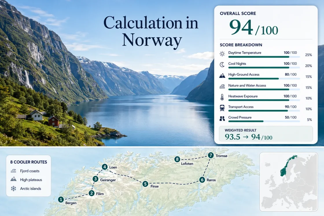
Coolcations in Norway: Fjords, Mountain Air and Long Summer Days
Norway’s strongest summer-cooling pattern does not come from one climate zone. It comes from moving between Atlantic coast, shaded fjord walls, high railway stations and Arctic islands. Bergen and the inner fjords can still produce warm, bright afternoons, while Finse, Røros, Tromsø and Lofoten preserve cooler nights or lower daytime temperatures. The practical advantage is range: a sea-level base can often be paired with a high road, cable car, mountain railway or exposed coast, although rain, seasonal road openings and July capacity pressure remain part of the trade-off.
Four fjord and coast bases, two high inland or plateau bases and two Arctic coastal bases.
Rail-only access places the overnight base directly on the Hardangervidda mountain plateau.
Midnight-sun latitudes extend usable outdoor hours but can interfere with sleep without dark curtains.
Loen Skylift links the Nordfjord shore with Mount Hoven in roughly five minutes.
Bergen, Flåm, Finse, Røros and Tromsø can function without a private car for the core stay.
Cruise, coach, ferry and limited-valley capacity can compress the same daylight hours in July.
Fjord Gateways, High Stations and Northern Islands
The selected bases show how Norway’s summer-comfort options shift from the wet west coast to high plateau rail stops, inland mountain towns and Arctic maritime air.
Markers show selected cooler-route regions and planning centers, not guaranteed legal parking, trailheads or exact viewpoints. Use each route card for Google Maps links and current access checks before traveling.
Norway Fjord, Highland and Arctic Suitability Score
Calculated from 7 disclosed factors, this transparent editorial suitability index uses climate, landscape, access and pressure evidence. It is not an official climate classification or a weather forecast.
Method: Official-normal synthesis using direct or representative stations; rounded route proxy values are normalized on the fixed daytime scale.
Raw: 17.6°C median: Bergen 18.6; Flåm 21.0; Geiranger 19.5; Loen 19.0; Finse 11.5; Røros 16.5; Tromsø 14.5; Svolvær 14.5°C.
Source mapping: Direct stations at Bergen, Finse, Røros and Tromsø; Aurland, Tafjord, Oldedalen and Svolvær Airport represent the remaining route centers.
Period: 1991–2020 where published; official station normal otherwise.
Sources: MET Norway normals; SeKlima.
Method: Official-normal synthesis using direct or representative stations; the factor measures overnight relief, not record cold.
Raw: 10.3°C median: Bergen 12.3; Flåm 11.5; Geiranger 10.8; Loen 10.8; Finse 4.3; Røros 6.5; Tromsø 8.5; Svolvær 9.8°C.
Source mapping: Same direct and representative stations as the daytime factor.
Period: Primarily 1991–2020 official normals.
Sources: MET Norway normals; SeKlima.
Method: Fixed elevation/access rubric; route median.
Raw: 80. Bergen 60; Flåm 80 via Myrdal; Geiranger 80 via seasonal high roads; Loen 80 via Hoven; Finse 100 at 1,222 m; Røros 80; Tromsø 80; Svolvær 60.
Route rationale: Formal rail, road or lift access scores above hiking-only altitude.
Period: Access reviewed 15 July 2026.
Sources: Vy Finse; Loen Skylift; Scenic Routes; Flåm Railway.
Method: Fixed rubric for coast, fjord, large lake or broad forest within 30 minutes; route median.
Raw: 100. Bergen, Flåm, Geiranger, Loen, Røros, Tromsø and Svolvær score 100; Finse scores 75 for mountain lakes without broad forest.
Route rationale: Physical access, not scenic quality, determines the score.
Period: Geographic access reviewed 15 July 2026.
Sources: Norwegian Mapping Authority; Entur.
Method: Official threshold-frequency proxy synthesis for 30°C+ days; no incomplete daily series is presented as an exact zero-count result.
Raw: 0.3% median: Bergen 0.3; Flåm 1.6; Geiranger 0.8; Loen 0.6; Finse 0.0; Røros 0.2; Tromsø 0.0; Svolvær 0.0%.
Source mapping: Same station pairings as the temperature factors; sheltered inner-fjord representatives carry the higher frequencies.
Period: Published official threshold climatology with mixed station periods.
Sources: MET Norway hot-day report; SeKlima.
Method: Fixed public-transport rubric; route median.
Raw: 90. Bergen 100; Flåm 80; Geiranger 40; Loen 60; Finse 100; Røros 100; Tromsø 100; Svolvær 60.
Route rationale: Direct rail or urban transit scores highest; seasonal ferry, dispersed trailheads and car-favored side valleys reduce scores.
Period: Network review 15 July 2026.
Sources: Entur; Bergen Line; Røros Railway; Lofoten buses.
Method: Official-evidence fallback using accommodation demand, transport capacity and seasonal access warnings; route median.
Raw: 50. Bergen 60; Flåm 20; Geiranger 20; Loen 40; Finse 60; Røros 80; Tromsø 60; Svolvær 40.
Route rationale: Compact fjord ports and limited island supply score below broad urban or rail-based capacity.
Period: 2023–2025 tourism data and 2026 access review.
Sources: Statistics Norway accommodation data; Scenic Routes notices; 2026 Nordland express boats.
Western Fjords, Plateau Rail Stops and Arctic Coast Bases
The route set separates true high-altitude cooling from sea-level places that depend on wind, water or fast access uphill. Each base solves a different part of the summer-heat problem.
Bergen
Bergen’s July–August signal is about 18.6°C by day and 12.3°C at night. Sea exposure limits persistent heat, while Fløibanen and Ulriken provide fast access to windier high ground. Airport rail, ferries, buses and the Bergen Line make the city fully car-light.
Flåm and Aurlandsfjord
The sheltered fjord floor runs near 21.0°C daytime and 11.5°C overnight. Cooling comes from vertical movement: the 20 km Flåm Railway climbs to Myrdal at roughly 867 m, while Aurlandsfjellet adds seasonal road access above 1,000 m.
Geirangerfjord
Geiranger’s sea-level signal is near 19.5°C by day and 10.8°C at night. Stronger cooling appears on roads toward Langvatnet and Dalsnibba, where elevation rises quickly. Ferries, coaches and seasonal roads make access more fragile than Bergen or Flåm.
Loen and Nordfjord
Loen averages about 19.0°C daytime and 10.8°C overnight. Loen Skylift reaches Mount Hoven at 1,011 m in roughly five minutes, producing the set’s fastest fjord-to-altitude shift. Lovatnet and Oldedalen widen the water and forest range.
Finse
Finse is the lowest-heat base at roughly 11.5°C by day and 4.3°C at night. The station and lodging sit on Hardangervidda at about 1,222 m. Train, foot or bicycle are the practical approaches; there is no normal road access.
Røros
Røros uses elevation and inland night loss rather than fjord wind: about 16.5°C by day and 6.5°C at night. The Røros Railway, buses, nearby forests and lakes support a car-light stay, with less summer compression than the main fjord ports.
Tromsø
Tromsø’s maritime pattern is near 14.5°C daytime and 8.5°C overnight. Airport links, buses, ferries and Fjellheisen keep the core stay car-light. The midnight sun usually lasts from about 20 May to 22 July.
Svolvær and Lofoten
Svolvær’s signal is near 14.5°C by day and 9.8°C at night. Flights, express boats and regional buses reach the base, while sea wind, fog and showers can change quickly around the Lofoten wall.
Which Norwegian Base Changes the Heat Trade-Off?
The same route set separates into cool coastal cities, warmish fjord floors with rapid altitude access, true high-ground bases and Arctic maritime bases.
| Route | July–August thermal signal | High-ground shift | Car-light practicality | Long-day effect | Main constraint |
|---|---|---|---|---|---|
| Bergen | 18.6°C / 12.3°C | Local funicular and cable car | Strong | Late evenings, no midnight sun | Rain and humidity |
| Flåm and Aurlandsfjord | 21.0°C / 11.5°C | Rail to Myrdal; seasonal high road | Strong for core corridor | Bright inner-fjord afternoons | Visitor concentration |
| Geirangerfjord | 19.5°C / 10.8°C | Seasonal roads toward high plateaus | Moderate to limited | Long driving window | Road, ferry and coach pressure |
| Loen and Nordfjord | 19.0°C / 10.8°C | Skylift to 1,011 m | Moderate | Late summit operating hours in peak summer | Lift weather and dispersed valleys |
| Finse | 11.5°C / 4.3°C | Already at 1,222 m | Strong by rail, narrow locally | Long plateau hiking window | Cold, wind and no road |
| Røros | 16.5°C / 6.5°C | Highland base near 628 m | Strong | Long evenings with real dusk | Large day–night swing |
| Tromsø | 14.5°C / 8.5°C | Cable car and island mountains | Strong | Midnight sun into late July | Sleep disruption and wind |
| Svolvær and Lofoten | 14.5°C / 9.8°C | Mostly hiking-based | Moderate | Midnight-sun season | Dispersed access and changing weather |
The Inner-Fjord Warmth Trap in Flåm and Geiranger
Cold-looking water does not guarantee the lowest daytime temperature: sheltered fjord floors can retain sun while open coasts and plateaus stay cooler.
Sea-Level Bases Remain Lowland Bases
Flåm and Geiranger sit close to sea level. On stable days they can run warmer than Finse, Røros, Tromsø or Lofoten; fjord water moderates extremes but does not reproduce plateau air.
Use Altitude During the Warmest Hours
Use the Flåm Railway, Geiranger high roads or Loen Skylift during late morning and afternoon. Return to the fjord floor as evening cooling begins.
Long Light Extends Solar Exposure
Long summer light can warm a favorable valley wall late into the day. Shaded rooms, exterior blinds and cross-ventilation may matter more than a glass-fronted view.
Rail Certainty, Lift Hours and Seasonal Mountain Roads
Rail-based altitude is comparatively predictable; high roads and exposed lifts remain sensitive to snow clearance, wind and local operating decisions.
Finse: Access Without a Road
Finse is reached by the Bergen Line, not by normal road. Rail reservations and walking distance to lodging matter more than parking, and trail snow can outlast normal train operation.
Geiranger: Open Does Not Mean Unconditional
Official notices warn that high stretches may close seasonally or temporarily in bad weather. Keep a valley or ferry fallback when a high-road day is central to the plan.
Loen: Long Summer Hours, Weather-Led Operation
Peak-summer hours can extend late, but wind and visibility still determine the value of the ascent. Check live status and the last-return time on the travel date.
Midnight Sun Changes Sleep More Than Temperature
Tromsø and Svolvær stay cool through latitude and maritime exposure, yet 24-hour light can reduce recovery when rooms remain bright.
Tromsø’s Late-May to Late-July Light Window
Visit Tromsø places the usual midnight-sun period around 20 May to 22 July. Blackout curtains and a cool room protect the value of 8–10°C nights.
Lofoten Uses Light as a Weather Buffer
Long light lets Lofoten plans move away from a wet afternoon, but bus and boat timetables still impose hard limits. The flexibility is greatest with a car.