Iceland for Cooler Escapes: Lava Fields, Coastal Air and Bright Summer Nights
Iceland’s summer advantage comes from high latitude, cold surrounding seas and frequent access to exposed coasts rather than reliably calm weather. Eight routes connect lava peninsulas, lake basins, fjord towns, offshore islands and glacier lagoons. July–August station records place the route-set median daytime maximum near 13.7°C, while wind, rain, fog and bright nights remain the main comfort trade-offs.
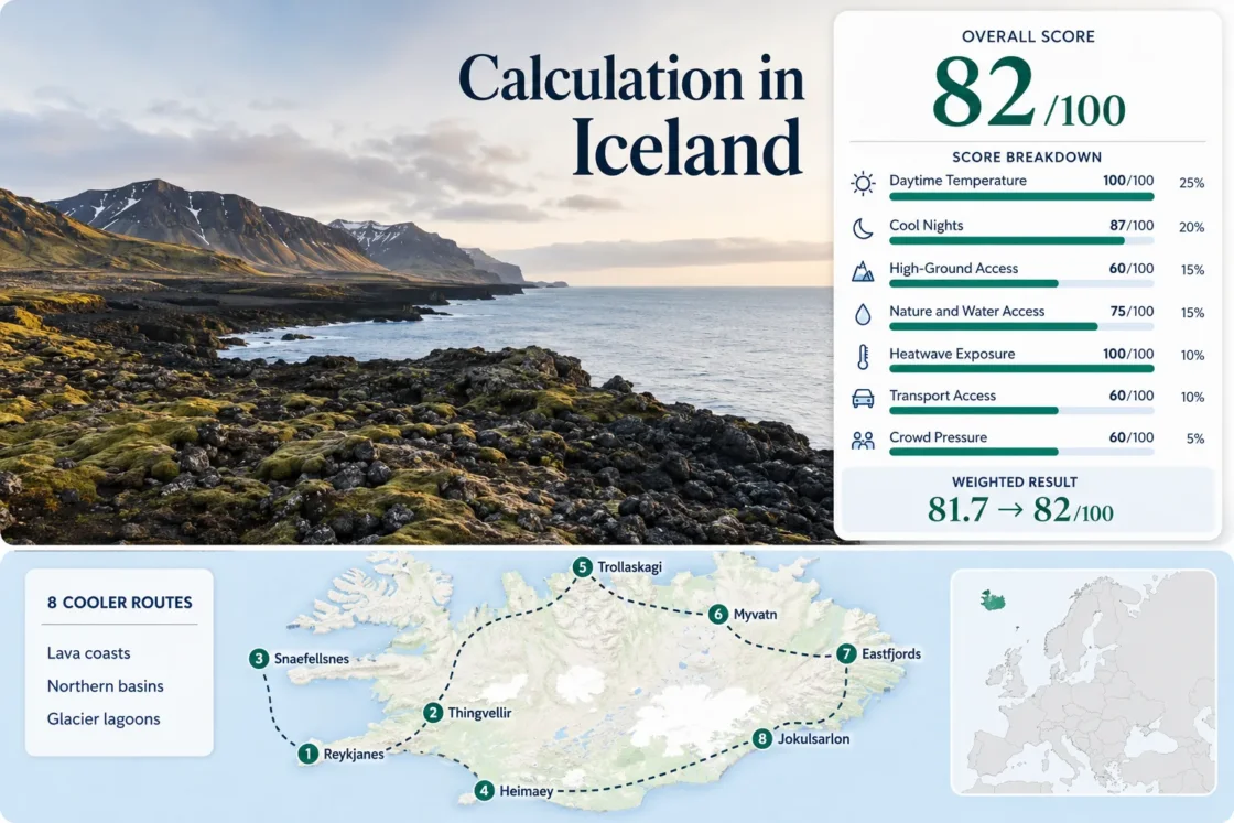
The map, score, route cards and comparison table use the same eight destinations.
This northern-summer window combines broad road access with the country’s highest travel pressure.
Calculated from available quality-controlled 1991–2020 daily station observations.
Cool nights are common, although exposed wind can make evening conditions feel sharper.
The exposed Eastfjords station records the coolest route-mapped daytime average.
A cool seasonal average never overrides live road, ferry, volcanic or weather restrictions.
Lava Coasts, Northern Basins and Glacier-Lagoon Routes
The markers span Reykjanes, Þingvellir, Snæfellsnes, Heimaey, Tröllaskagi, Mývatn, the Eastfjords and Jökulsárlón, separating exposed maritime routes from more sheltered northern basins.
Markers show selected cooler-route regions and planning centers, not guaranteed legal parking, trailheads or exact viewpoints. Use each route card for Google Maps links and verify live access before traveling.
Iceland Lava-Coast and Bright-Night Suitability Score
This transparent editorial suitability index uses disclosed climate, landscape, access and pressure factors. It is not an official climate classification or a weather forecast.
Why the result is high: Exceptionally low peak-summer heat outweighs car dependence, exposed weather and concentrated July–August demand.
Weighted total: 100×0.25 + 87×0.20 + 60×0.15 + 75×0.15 + 100×0.10 + 60×0.10 + 60×0.05 = 81.7 → 82/100
Method: Route count adds no bonus. Route-level values are combined by median before the seven fixed weights are applied. Quality C reflects representative stations, mixed observation completeness and categorical transport or pressure evidence.
Lava Peninsulas, Fjord Towns and Glacier-Edge Bases
These routes separate exposed maritime cooling, sheltered northern basins and glacier-influenced southeast travel. Ferry timing, road status and lodging can outweigh temperature on any single day.
Reykjanes Lava Coast
Keflavík’s route-mapped July–August averages are 13.7°C by day and 8.7°C at night. Reykjanesviti, Gunnuhver and the exposed southwest shore sit close to the airport, yet a car gives far more control over legal access points and sudden wind changes.
Þingvellir–Laugarvatn
Representative Reykjavík records give 14.5°C daytime and 8.9°C night-time averages. Þingvallavatn, birch-covered parkland and the rift escarpment create a cooler-feeling inland base, but sheltered sunny periods can feel warmer than the coastal station suggests.
Snæfellsnes–Stykkishólmur
Stykkishólmur provides a near-direct station signal of 13.6°C by day and 8.4°C at night. The peninsula combines lava fields, fishing towns, sea wind and steep relief without requiring an interior F-road itinerary.
Heimaey and Vestmannaeyjar
Vestmannaeyjar records average 12.6°C by day and 8.9°C at night, the lowest direct daytime figure in the route set after the exposed Eastfjords proxy. The harbor town, Eldfell slopes and cliff-lined coast fit into a compact island plan.
Tröllaskagi and Siglufjörður
Akureyri’s representative signal is 14.9°C by day and 8.2°C at night. Siglufjörður sits at sea level beneath steep mountains, so the route gains dramatic elevation contrast without committing to a remote highland road.
Mývatn–Krafla
Akureyri’s lower-elevation representative station gives 14.9°C daytime and 8.2°C night-time averages. Mývatn’s roughly 277 m lake base, Krafla uplands and lava formations create a distinct inland volcanic route with strong lake access.
Seyðisfjörður and Eastfjords
Dalatangi’s exposed station averages 11.2°C by day and 7.2°C at night, the coldest mapped climate signal. Inner Seyðisfjörður can be calmer and somewhat warmer, but the route retains strong fjord air and a clear sea-to-pass elevation change.
Hornafjörður and Jökulsárlón
Hornafjörður averages 13.8°C by day and 8.2°C at night. Route 1 connects Atlantic exposure, glacial lagoons and Vatnajökull, but the cooler air comes with long distances and limited public-transport flexibility.
Reykjanes Cooling Depends on the Live Hazard Boundary
The Svartsengi Map Overrides a Scenic Detour
The official hazard map accounts for seismicity, sinkholes, fault movement, eruptive fissures, lava flow, tephra and volcanic gas. A route should be rebuilt around the live boundary rather than around a saved pin.
Fresh Lava Is Not a Walking Surface
New lava can retain heat, conceal unstable cavities and release gas. The visually newest ground is often the least appropriate place for an improvised stop, even in cold wind.
Keep a Southwest Fallback Outside the Closure
When one sector closes, a safer plan may shift toward Reykjanesviti, Garður, Sandgerði or Reykjavík rather than trying to approach the active zone from another road.
Bright Nights Change Sleep and Driving More Than Temperature
Northern Routes Lose Darkness First
Siglufjörður and Mývatn sit farther north than Reykjanes or Heimaey, so evening light persists longer. The extra visibility can help with early hiking starts but can also delay sleep.
Blackout Control Is a Practical Climate Tool
Blackout curtains, an eye mask and a fixed bedtime matter because the body receives weak darkness cues. A cold room does not guarantee restorative sleep when twilight remains outside the window.
Long Daylight Encourages Overlong Road Days
Bright evening conditions make a late arrival feel harmless, yet wind, one-lane bridges and long empty stretches still demand full attention. Set a stopping time before leaving the morning base.
Which Iceland Route Fits the Day’s Constraint?
The same cool forecast leads to different choices when the limiting factor is ferry capacity, mountain visibility, car dependence, bright-night fatigue or lodging pressure.
| Route | July–August climate signal | Access pattern | Cooling landscape | Main limiter | Decision window |
|---|---|---|---|---|---|
| Reykjanes Lava Coast | 13.7°C day / 8.7°C night | Airport-adjacent; car useful | Atlantic wind and open lava | Live volcanic closures and gas | Use only after same-day hazard and road checks |
| Þingvellir–Laugarvatn | 14.5°C / 8.9°C representative | Easy road access from Reykjavík | Large lake, birch cover and rift relief | Parking and concentrated visitors | Early morning or later evening outside the busiest arrival band |
| Snæfellsnes–Stykkishólmur | 13.6°C / 8.4°C direct | Long road circuit; car-led | Ocean exposure, lava and glacier relief | Seasonal high roads and long mileage | Clear-visibility day with a conservative turnaround time |
| Heimaey and Vestmannaeyjar | 12.6°C / 8.9°C direct | Daily ferry; compact island | Marine air, cliffs and volcanic slopes | Wind and sailing changes | Book around the ferry, not around a fixed island checklist |
| Tröllaskagi and Siglufjörður | 14.9°C / 8.2°C representative | Regional bus or road | Fjord coast and steep mountain walls | Tunnel, road and cloud conditions | Useful car-light choice when northern roads remain stable |
| Mývatn–Krafla | 14.9°C / 8.2°C representative | Bus corridor; sights dispersed | Lake basin, lava and uplands | Midges, sun and local driving | Windier day or early start can reduce insect pressure |
| Seyðisfjörður and Eastfjords | 11.2°C / 7.2°C exposed proxy | Bus from Egilsstaðir or road pass | Fjord air and high pass | Low cloud and pass visibility | Choose when the pass forecast and visibility agree |
| Hornafjörður and Jökulsárlón | 13.8°C / 8.2°C near-direct | Ring Road; long transfers | Atlantic coast, glacial lagoons and ice margins | Rooms, parking and distance | Reserve the overnight base before committing to the southeast |
Road Openings, Peak Demand and the Return of Darkness
Late May to June
Coastal routes gain very long daylight before peak July pressure, but some high roads and F-roads may remain closed or unsuitable. Snæfellsnes, Reykjanes and Þingvellir are generally easier to structure than a highland-dependent itinerary.
July to Mid-August
Road access is broadest and the route-set climate remains cool, yet hotel occupancy, ferry seats, rental cars and major parking areas carry the greatest pressure. Advance lodging matters most in the East and South.
Late August to September
Darkness begins returning and some booking pressure eases, but Atlantic storms, pass visibility and shorter service windows gain importance. Remote fjord or island days need a stronger weather fallback.
Three Live Checks Before an Iceland Route Day
Wind and Visibility
Temperature alone misses the variables that cancel exposed walks, close passes or turn a comfortable coast into a difficult stop. Compare wind, gusts, precipitation and visibility for the actual route.
Road Status and Surface
A green-looking map route may include gravel, a seasonal mountain road or a weather-sensitive pass. Check the live road layer before departure and again before a long branch away from Route 1.
Ferry, Parking and Lodging Capacity
Heimaey sailings, Þingvellir parking and southeast accommodation are finite. Secure the capacity-limited element first, then build the cooler landscape around it.
Iceland’s low summer temperatures do not guarantee easy conditions. Keep one flexible day, avoid stacking long road segments and treat wind, visibility, closures and fatigue as seriously as the thermometer.