Cape Verde for Breezier Island Travel: Mountain Valleys, Trade Winds and Atlantic Air
Cape Verde is warm rather than cold, yet its islands produce sharply different comfort patterns. Open Atlantic coasts gain persistent air movement, volcanic ridges add elevation, and deep valleys trade wind exposure for shade and greener terrain. January and February provide the clearest overlap of milder daytime conditions and established northeast trade winds, while the same breeze can also bring blowing sand, dry air and occasional Saharan dust.
Two low, exposed beach bases and five routes with meaningful high-ground access.
The mildest part of the annual cycle overlaps with the more dependable trade-wind period.
Exposed coasts usually feel breezier; valleys and leeward slopes can be much calmer.
Fogo, Santo Antão and São Nicolau change thermal exposure within relatively short road distances.
Saharan dust is most relevant from December into February and can mute long-distance views.
Santo Antão depends on the São Vicente ferry; São Nicolau and Fogo require more schedule tolerance.
Atlantic Coasts, Windward Ridges and Volcanic Interiors
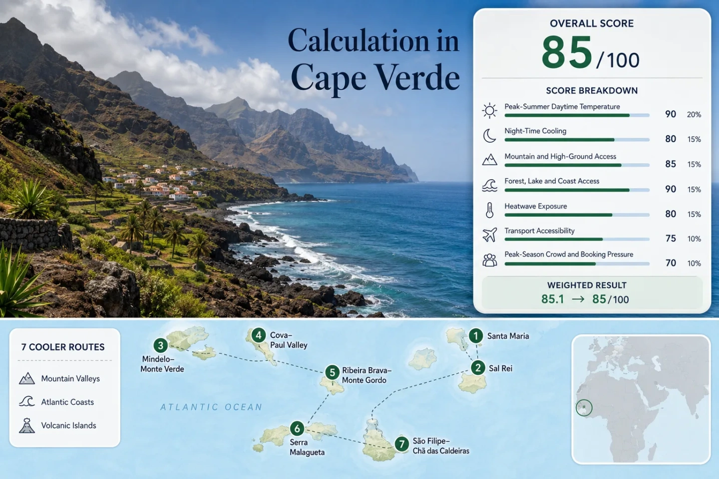
The selected markers connect exposed beach towns with mountain routes where elevation, cloud contact or valley shade changes the thermal experience. The map is for planning orientation rather than turn-by-turn navigation.
Markers show selected cooler-route regions and approximate planning centers, not guaranteed legal parking, trailheads or exact viewpoints. Use the Google Maps links and current local access information before traveling.
Cape Verde Breezy-Island Suitability Score
This transparent editorial suitability index applies seven fixed climate, landscape, access and pressure factors to the same seven routes shown on the map. It is not an official climate classification or a weather forecast.
Weighted total: 91×0.25 + 73×0.20 + 80×0.15 + 100×0.15 + 100×0.10 + 80×0.10 + 60×0.05 = 85.4 → 85/100
Method: Route count does not add bonus points. Route-level values are combined using the median before the fixed weights are applied. Climate comparability is limited by sparse highland station coverage and mixed publication periods.
Trade-Wind Coasts, Mountain Valleys and High Volcanic Roads
Each route relies on a different cooling mechanism. Coastal air movement is strongest on Sal and Boa Vista; the remaining routes add elevation, cloud contact, valley shade or cooler night conditions.
Santa Maria and Sal’s Open Southern Coast
Santa Maria is the clearest wind-led option: a low coastal base with little terrain to interrupt the northeast trades. The January–February representative maximum is about 24.1°C, the minimum about 18.5°C, and meaningful high ground is limited. Comfort comes from moving air rather than altitude.
Sal Rei and Boa Vista’s Western Shore
Sal Rei combines a compact town base with broad coastal exposure. Published January values center near 24°C by day and 19°C at night. Rabil airport keeps the transfer simple, but dunes and open beaches leave little protection when the wind strengthens.
The key trade-off is calm-water preference versus air movement: a sheltered beach may feel warmer than an exposed stretch only a short distance away.
Mindelo to Monte Verde
Mindelo begins at a dry harbor city and gains access to Monte Verde’s roughly 700 m high ground by road. The coastal climate proxy is about 22.7°C maximum and 21.3°C minimum in the target window, while the climb introduces stronger exposure, cloud contact and a more noticeable evening temperature shift.
Laginha and the harbor can be breezy without being cold; Monte Verde is the route to use when moving air alone is not enough. Monte Verde on Google Maps
Cova Crater and Paul Valley
The route crosses one of Cape Verde’s sharpest airflow transitions. Cova’s rim and the old mountain road are exposed; the cultivated valley becomes progressively more enclosed toward the coast. A representative base proxy of 22.8°C by day and 19.5°C at night does not capture every altitude band, so the practical difference comes from where the day is spent.
The São Vicente–Porto Novo ferry adds a fixed transfer before road transport or an aluguer. Cova and Paul Valley on Google Maps
Ribeira Brava and Monte Gordo
São Nicolau offers a mountain-air alternative to the resort islands. Ribeira Brava provides the service base; Monte Gordo adds a forested highland environment and the island’s strongest elevation advantage. The lower-base proxy is about 22.5°C maximum and 18.5°C minimum, with cooler conditions likely on the park’s higher trails.
Access is the limiting metric: island connections are less frequent than the São Vicente–Santo Antão corridor, and local road planning matters. The reward is a route where shade, elevation and Atlantic exposure overlap.
Serra Malagueta above Santiago’s Warmer Lowlands
Serra Malagueta is the clearest highland counterpoint to Praia’s built-up coast. The published 23.0°C maximum and 19.0°C minimum values are lowland proxies; the park’s elevation, vegetation and occasional cloud make the route materially different from the station base.
São Filipe to Chã das Caldeiras
Fogo shifts from a warm coastal town to a high caldera with large open slopes and limited shade. The local highland climatology used in the score is about 21.7°C maximum and 19.7°C minimum for January, but direct sun on dark volcanic ground can raise heat stress during exposed walks.
The road climb supplies altitude without guaranteeing wind. Caldera walls can shelter sections, while rims and open lava fields remain exposed. Evening cooling is more useful here than the mid-afternoon breeze.
Why the Same Trade Wind Feels Different Across the Islands
Airflow is only one part of comfort. Relief determines whether the northeast trades arrive uninterrupted, accelerate over a ridge or weaken inside a valley.
Sal and Boa Vista: Continuous Exposure
Low relief lets Atlantic air cross long beaches and open plains with limited interruption. This improves evaporation and terrace comfort, but also increases blowing sand, salt exposure and wind fatigue. A wall, dune or hotel block can create a much warmer pocket only a few metres from an exposed shore.
Monte Verde, Cova and Serra Malagueta: Ridge Acceleration
Wind can strengthen as it is forced over passes and crests. These high points add lower air temperatures and occasional cloud, yet gusts can make walking less stable. A light layer has more value on a ridge road than on Santa Maria’s beach at the same hour.
Paul Valley and Chã das Caldeiras: Sheltered Interiors
Valley walls and caldera rims can reduce the breeze. Paul gains vegetation and shade but may feel more humid; Chã gains altitude but has dark ground and little shade. Neither should be described as uniformly cool from morning to evening.
The Mindelo–Porto Novo Crossing Changes the Climate Strategy
Use Mindelo for Air Access and Flexible High Ground
São Vicente combines an airport, urban services, a breezy harbor and a road to Monte Verde. It works as a lower-complexity base when daily conditions are uncertain: the coast remains available, while the mountain road provides a same-island elevation change.
Cross to Santo Antão for Deeper Terrain Contrast
The scheduled ferry to Porto Novo is typically about an hour, followed by road travel toward Cova, Ribeira Grande or Paul. The old mountain road gains wind and cloud exposure; the descent into the northeast valleys reduces exposure and increases vegetation. Ferry and road timing therefore shape thermal comfort as much as the destination name.
Which Route Matches Each Type of Breeze Tolerance?
| Route | January–February climate proxy | Primary relief mechanism | Access pattern | Main trade-off |
|---|---|---|---|---|
| Santa Maria | 24.1°C / 18.5°C | Continuous Atlantic airflow | Airport plus short road transfer | Little shade; sand and gust exposure |
| Sal Rei | 24.0°C / 19.0°C | Open western coast | Airport plus local transfer | Sheltered beaches can feel warmer |
| Mindelo–Monte Verde | 22.7°C / 21.3°C | Coast-to-ridge elevation change | Airport city and road climb | Warm nights at the coast; gustier high ground |
| Cova–Paul Valley | 22.8°C / 19.5°C | Crater rim, valley shade and vegetation | Ferry plus mountain road | Calmer, more humid air inside the valley |
| Ribeira Brava–Monte Gordo | 22.5°C / 18.5°C | Forested highland access | Limited island links plus road transfer | Greater schedule complexity |
| Serra Malagueta | 23.0°C / 19.0°C lowland proxy | Vegetated Santiago highlands | Airport island and road transfer | Proxy understates the elevation difference |
| São Filipe–Chã das Caldeiras | 21.7°C / 19.7°C | High caldera and night cooling | Domestic air or ferry plus long climb | Intense sun and limited shade |
Dry Mist, Strong Sun and the False Sense of Coolness
Bruma Seca Can Reduce Visibility
Dry Saharan air and suspended dust are most relevant from December through February. Mountain panoramas may disappear even when rain is absent, and sensitive travelers may notice throat, eye or breathing irritation.
Wind Does Not Reduce Solar Exposure
Air movement lowers skin heat sensation without lowering ultraviolet intensity. Long coastal walks and exposed caldera routes need sun protection, water and planned shade even when the breeze feels comfortable.
A Breezy Shore Is Not Automatically Calm Water
Wind direction, swell and local shelter determine swimming conditions. Sal and Boa Vista can provide strong air movement while an exposed beach remains rougher than a nearby leeward bay.
Choose Accommodation by Exposure, Shade and Night Ventilation
Beach distance alone is a weak predictor of comfort. A fully exposed seafront room may be noisy and difficult to ventilate in strong gusts, while a sheltered courtyard can become warm when the trade wind weakens. Mountain bases add cooler evenings but can require steep access and more transport planning.
On Sal, Boa Vista and Mindelo
Check whether windows allow genuine cross-ventilation, whether shutters can remain secure, and whether the room receives direct western sun. Partial wind shelter is often more usable than a balcony facing the full Atlantic flow.
In Paul, Ribeira Brava and Chã
Ask about the walking gradient from the road, evening temperature, reliable hot water and transport to the trail start. Deep-valley lodging gains shade and greenery; ridge lodging gains airflow but may be cooler, cloudier and more exposed.