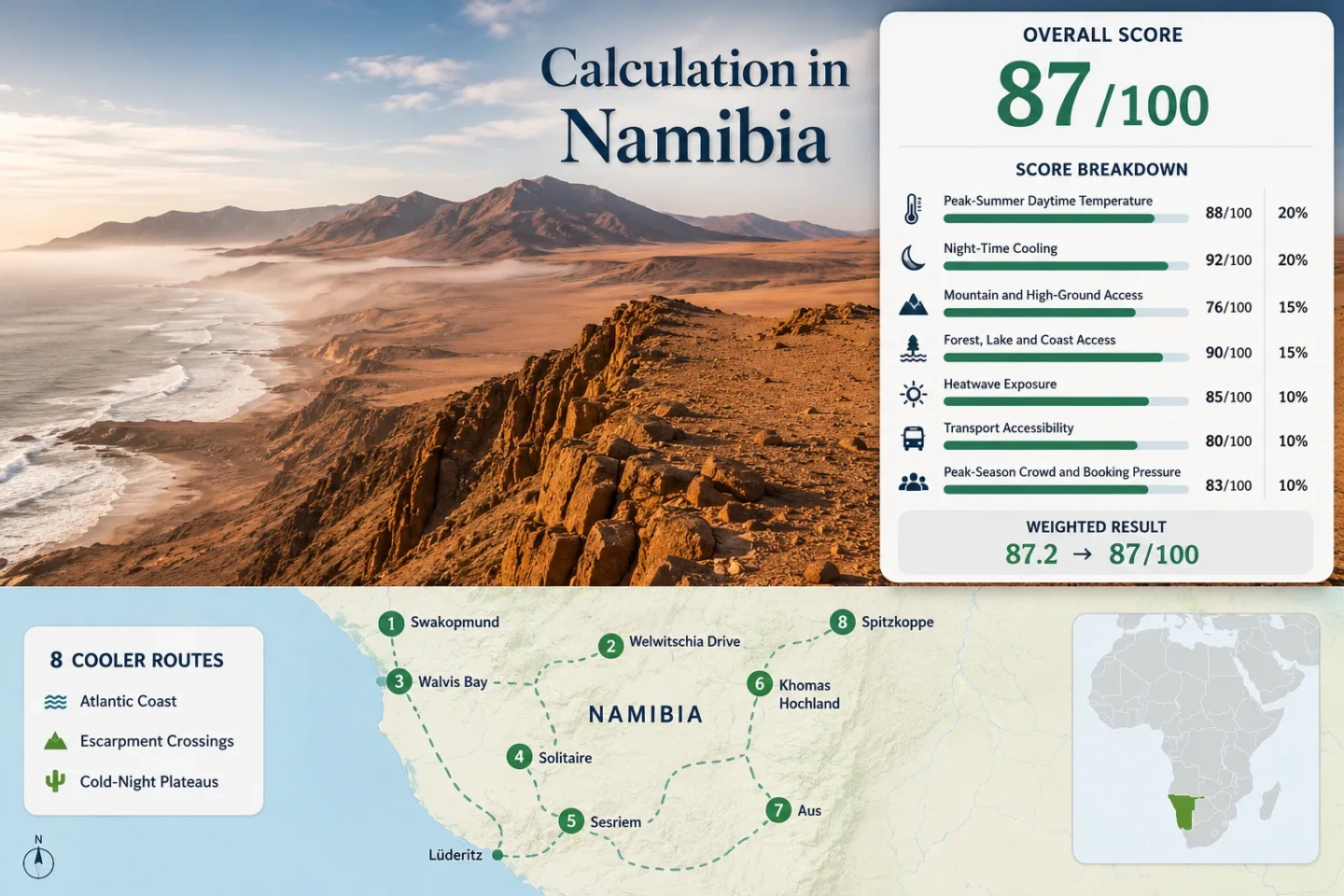
Namibia Cool Dry-Season Routes: Desert Plateaus, Atlantic Fog and Clear Cold Nights
Namibia’s June–July cooling is produced by three different systems rather than one nationwide winter pattern. The Atlantic coast can remain mild under fog and cold marine air, the central and southern plateaus lose heat rapidly after sunset, and exposed desert basins can move from near-freezing dawn conditions to strong solar heat before midday. Route choice therefore depends on when the cooling occurs, how long it lasts and whether permits, tide or gravel-road access restrict the cooler corridor.
Three Atlantic routes, three escarpment or interior crossings and two high-country combinations are assessed with equal route weight.
The score follows the title’s cold-season intent rather than Namibia’s October–April summer calendar.
Swakopmund, Lüderitz and the Aus–Lüderitz corridor provide the portfolio’s strongest daytime moderation.
High bases and clear dry air create a stronger night-time temperature drop than the fog-cooled coast.
Welwitschia Drive, Sandwich Harbour and restricted Tsau //Khaeb sectors require more than ordinary road planning.
Sesriem, Kuiseb and granite routes can lose their cool-air advantage quickly after direct sun reaches the surface.
Atlantic Fog Corridors, Escarpment Crossings and Cold-Night Plateaus
Markers show route-planning centers for the eight assessed corridors. They do not identify guaranteed legal parking, exact viewpoints, trailheads or safe tide lines.
Marker positions use approximate public location centers where a corridor covers several towns, passes or protected-area sectors. Route cards contain Google Maps searches and the access distinction that matters before travel.
Namibia Dry-Season Cooler Escape Suitability Score
This is a transparent editorial suitability index based on disclosed climate, landscape, access and pressure factors. It is not an official climate classification or a weather forecast. Route values use public climate tables, representative stations and fixed categorical rubrics; mixed station periods and route-center proxies reduce comparability.
Weighted total: 83×0.25 + 82×0.20 + 80×0.15 + 23×0.15 + 75×0.10 + 40×0.10 + 70×0.05 = 67.6 → 68/100
Method: Every route carries equal weight. Each factor is calculated from the median of the same eight route values, so a single cold coast or high plateau cannot lift the whole result by itself.
Coastal Fog Roads, Desert Passes and High-Country Night Routes
The route set separates stable daytime cooling from cold-night relief. Coastal corridors usually keep afternoons milder, while Khomas, Aus and the interior desert routes create the larger temperature fall after sunset.
Swakopmund–Henties Bay–Cape Cross
The long coastal run north of Swakopmund keeps the cold Atlantic within reach for most of the day. Fog, low cloud and onshore wind can hold daytime temperatures well below those of the interior, while the small night–day range makes this a more stable thermal choice than the plateau routes.
Henties Bay provides the most practical service base before the road continues toward Cape Cross. The same marine layer that suppresses heat can also reduce visibility, wet exposed equipment and make an open roadside stop feel colder than the thermometer suggests.
Swakopmund–Moon Landscape–Welwitschia Drive
This corridor is valuable because the cooling mechanism changes during the drive. Swakopmund may begin under marine fog, yet the Moon Landscape and Welwitschia sector can sit beyond the strongest ocean influence, with brighter sun and faster warming over bare gravel and dark rock.
The route therefore works as a thermal transition rather than an all-day cool corridor. An early departure captures the marine layer and the coldest interior air; a late return can feel markedly warmer even when the coast remains grey.
Walvis Bay–Sandwich Harbour
Walvis Bay supplies a mild coastal base, but the route south is controlled by sand, tide and legal access rather than temperature alone. The lagoon and shore can remain cool under low cloud while sheltered dune faces warm rapidly once the sun clears.
Sandwich Harbour should not be treated as a normal self-drive road. Access decisions depend on permits, tide, sand state and operator practice, making it a stronger choice for planned coastal cooling than for spontaneous detours.
Kuiseb Pass–Gaub Pass–Solitaire
The pass sequence crosses the divide between marine-influenced gravel plains and the warmer interior. Exposed high points can feel cool in the morning, yet the descent toward Solitaire removes much of the Atlantic moderation and increases the afternoon heat load.
This is one of the clearest routes for separating elevation from lasting daytime cooling. A pass may be windy and fresh while the next basin is calm and much warmer, so distance and time of day matter as much as the overnight minimum.
Sesriem–Sossusvlei–Naukluft Edge
Sesriem can be cold before sunrise because dry air and open sky allow strong overnight heat loss. That comfort window narrows quickly after the sun reaches the dune faces, especially on exposed walks with little shade.
Naukluft-side elevation provides a different form of relief from the low dune basin, but the two should not be scored as one continuous cool environment. Gate timing, the final sandy access toward Sossusvlei and the return hour determine whether the day remains mild or becomes a high-radiation desert outing.
Khomas Hochland–Spreetshoogte Pass
Khomas Hochland starts high enough for cold mornings and persistent night relief, giving it the strongest high-ground profile in the portfolio. The pass then compresses a large elevation change into a short distance, so the air can warm quickly on the descent toward the Namib.
The plateau remains exposed to sun and wind rather than shaded. Its advantage is cooler air and cold nights, not forest cover, and the steep pass should be assessed separately from the easier paved approach roads around Windhoek and Rehoboth.
Aus–Garub–Lüderitz
Aus and Lüderitz create the strongest two-part cooling pattern in southern Namibia. Aus sits high enough for sharply cold, clear nights, while Lüderitz trades altitude for persistent Atlantic wind and lower daytime heat.
The B4 makes the main town-to-town movement simpler than many gravel routes, but side trips into Tsau //Khaeb cannot be assumed to be open. Kolmanskop is publicly accessible under its own arrangements; Pomona and Bogenfels operate through controlled concession access.
Spitzkoppe–Erongo Highlands
Spitzkoppe benefits from dry-season night cooling, but its exposed granite stores and reradiates daytime heat. Open camps can become cold after sunset while rock-adjacent walking areas remain warm well into the evening.
The higher Erongo settings moderate the pattern more effectively than the open plains, although access generally remains vehicle-dependent. This route scores for night relief and topographic variation rather than for a consistently low afternoon maximum.
Benguela Fog, Escarpment Air and Desert Radiation
The same dry-season forecast can produce three different travel experiences because Namibia’s coastal current, plateau elevation and cloudless interior do not cool the landscape in the same way.
Atlantic Marine Layer
The cold Benguela Current suppresses coastal heat around Swakopmund, Walvis Bay and Lüderitz. Fog commonly reduces solar input in the morning and may return late in the day, but the benefit arrives with damp air, wind and variable visibility.
Plateau and Escarpment Air
Khomas Hochland, Spreetshoogte and Aus gain cooling from elevation, yet open terrain provides little shade. A high road can remain mild while a nearby lower basin heats rapidly after descent.
Clear-Sky Night Loss
Sesriem, Kuiseb, Spitzkoppe and other dry interiors lose surface heat efficiently under clear winter skies. The resulting cold dawn is real, but it does not guarantee a low afternoon maximum once bare sand, gravel and granite receive direct sun.
Where Atlantic Cooling Ends and Interior Heat Returns
The eight corridors differ most in the timing of their temperature recovery. A route that is cold at 07:00 may rank below a fog-bound coast by early afternoon.
| Corridor | Cooling mechanism | Day profile | Night profile | Access constraint |
|---|---|---|---|---|
| 1. Swakopmund–Henties Bay–Cape Cross | Marine fog and cold Atlantic air | Low and comparatively stable | Cool rather than severe | Fog visibility and reserve entry |
| 2. Swakopmund–Moon Landscape–Welwitschia Drive | Fog-edge transition into bare gravel plains | Cool start, warmer interior finish | Cool; stronger inland than at the coast | Permit before Welwitschia Drive |
| 3. Walvis Bay–Sandwich Harbour | Marine air, lagoon exposure and dune wind | Mild near water; warmer on sheltered dunes | Cool and less variable | Permit, tide and specialist 4WD |
| 4. Kuiseb Pass–Gaub Pass–Solitaire | Pass elevation followed by interior warming | Moderate early, warmest near Solitaire | Cold in exposed basins | Long gravel stages and tyre risk |
| 5. Sesriem–Sossusvlei–Naukluft Edge | Clear-sky dawn cooling with rapid solar recovery | Cold dawn, fast late-morning rise | Cold to near-freezing in exposed sites | Park timing and final sandy access |
| 6. Khomas Hochland–Spreetshoogte Pass | High plateau air and escarpment wind | Mild plateau; warmer after descent | Very cold on clear, calm nights | Steep pass and vehicle control |
| 7. Aus–Garub–Lüderitz | High inland nights plus a wind-cooled coast | Cool coast and mild high-country days | Cold around Aus; milder at Lüderitz | Restricted Tsau //Khaeb side routes |
| 8. Spitzkoppe–Erongo Highlands | Dry night cooling with granite heat storage | Moderate, with hot rock surfaces | Cold after sunset | Car-dependent gravel access |
June–July Timing Across the Coast, Plateau and Dune Basins
The dry-season core strengthens night cooling before it guarantees mild afternoons. The practical window changes by route type rather than moving uniformly across Namibia.
Late May: The Temperature Split Begins
Interior nights begin to cool sharply, but stored summer heat can still produce warmer afternoons in Solitaire, Sesriem and western Erongo. The coast already offers a more dependable daytime buffer.
June: Cold Nights Become Operational
Camping insulation, pre-dawn gloves and vehicle cold starts become relevant around Khomas, Aus and exposed desert basins. Coastal fog remains a visibility issue rather than a frost issue.
July: The Clearest Contrast
The plateau and interior reach their strongest cold-night profile, while the Atlantic coast retains mild days. Sossusvlei sunrise demand and limited winter lodging can make timing and booking pressure more important than temperature.
August: Afternoon Recovery Strengthens
Cold mornings persist, but interior routes warm faster and east-wind events can disrupt the normal coastal pattern. The reliable cool-air window shifts toward early morning, high bases and the immediate coast.
Permits, Tides and 2026 Road Checks Can Change the Cooler Choice
Welwitschia Drive Is Not an Unrestricted Detour
The main road through Namib-Naukluft does not always require a permit, but the environment ministry identifies Welwitschia Drive and other special sectors separately. A permit should be secured before treating the route as a same-day extension from Swakopmund.
Sandwich Harbour Depends on More Than Weather
Cool marine air does not make the shoreline route usable. Tide, sand, permit conditions and specialist 4WD practice determine whether the corridor can be entered safely and legally on a given day.
Southern Roads Need a Fresh Status Check
The Roads Authority reported temporary closures in the ǁKaras Region after heavy rainfall in February 2026 and advised drivers to follow official closure notices. Dry-season travel reduces flood risk, but earlier washaways, grading and local repairs can still affect the Aus, Lüderitz and Helmeringhausen approaches.
Tsau //Khaeb Side Routes Remain Controlled
Kolmanskop is open under public visitor arrangements, while Pomona and Bogenfels are tied to concession access from Lüderitz. The cool Aus–Lüderitz spine should not be expanded into unrestricted park driving on the strength of a map line.
Packing for Fog Coast, Plateau Frost and Dawn-to-Hot Desert Days
Fog-Coast Layering
A wind-resistant outer layer, light insulation and a cloth for lenses or vehicle glass suit Swakopmund, Walvis Bay and Lüderitz. Cloud and fog do not remove ultraviolet exposure.
Plateau Night Insulation
Aus and Khomas require more attention to sleeping insulation, warm headwear and pre-dawn hand protection. Ground-level cold can be stronger than a town-based forecast suggests.
Cold-Dawn Desert Layers
Sesriem, Kuiseb and Spitzkoppe need removable layers, water capacity, sun protection and a planned shade strategy. The jacket worn at the gate may be packed away before the exposed walk is complete.