Morocco Beyond the Summer Heat: Atlas Villages, Atlantic Towns and High Valleys
Morocco’s strongest summer alternatives to the hot interior rely on two very different systems: Atlantic upwelling and wind along the coast, and elevation-driven cooling in the Atlas Mountains. Essaouira and Imsouane moderate daytime heat without producing especially cool nights, while Oukaïmeden, Ifrane and the Toubkal valleys provide larger temperature drops after sunset. The practical trade-off is access: the easiest car-light bases are not always the coolest after dark.
Five Atlas or high-plateau bases and three Atlantic towns form the shared map, score and comparison set.
The route-centre climate proxy is close to 21.5°C for the July–August average daily maximum.
A base near 2,600 metres produces the clearest overnight contrast with Marrakech and Morocco’s lower valleys.
Atlantic wind limits afternoon heat; Atlas elevation is more effective at lowering night-time temperatures.
Asilah has direct rail access, while Essaouira is served by regular intercity coaches from major hubs.
A high village can remain hot in direct afternoon sun, while a mild Atlantic town may feel windy rather than beach-warm.
Atlas Heights and Atlantic Cooling Bases
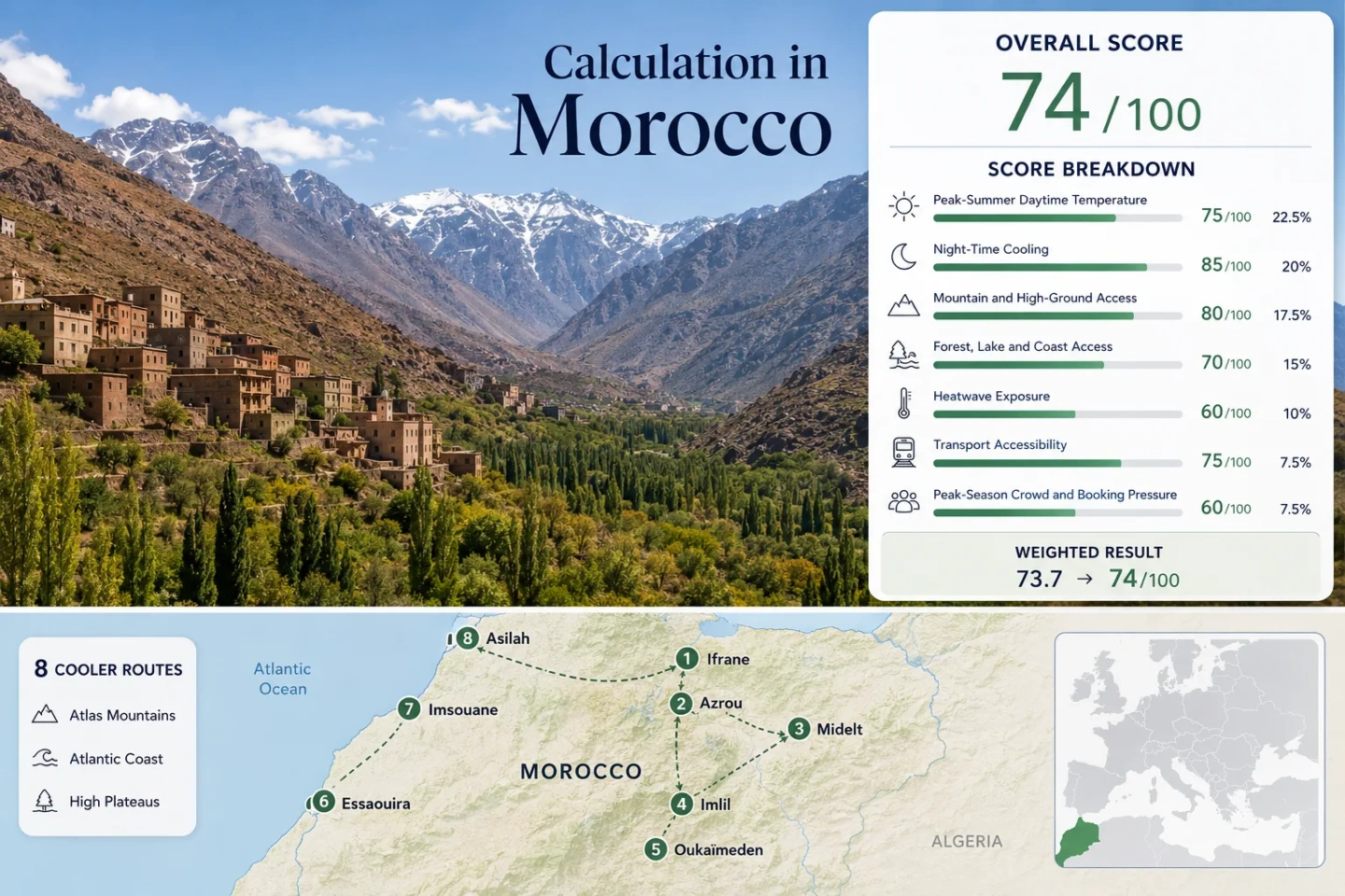
The markers connect Middle Atlas towns, High Atlas valleys, an elevated plateau city and three Atlantic bases. The route numbers match the destination cards and comparison table.
Markers show selected cooler-route regions and approximate public location centres, not guaranteed legal parking, trailheads or exact viewpoints. Use the destination links and current local access information before travelling.
Morocco Atlas and Atlantic Cooler Escape Suitability Score
This transparent editorial suitability index is based on disclosed climate, landscape, access and pressure factors for the eight displayed routes. It is not an official climate classification or a weather forecast.
Weighted total: 48×0.25 + 96×0.20 + 100×0.15 + 75×0.15 + 59×0.10 + 80×0.10 + 60×0.05 = 74.4 → 74/100
Method: Route count does not add bonus points. Each route receives equal weight inside a factor, route values are combined through the median, and the seven fixed factor weights are then applied.
Cedar Towns, Toubkal Valleys and Atlantic Wind Bases
The mountain routes offer larger overnight temperature drops, while the coast provides the lowest daytime heat exposure. None should be treated as heat-proof: direct sun, sheltered streets and regional hot-air intrusions can still create uncomfortable periods.
Ifrane and the Middle Atlas Cedar Belt
Elevation changes the daily rhythm: Ifrane sits at about 1,650 metres and is surrounded by cedar country, springs and lake districts. Its July–August route-centre proxy is approximately 28.5°C by day and 14.5°C at night, making evenings notably more useful for cooling than in Fès or Meknès.
Intercity coaches and shared connections make Ifrane one of the more practical mountain bases without a private vehicle. Dayet Aoua and the wider forest belt add shaded or waterside alternatives, although lakeside conditions can be exposed during the middle of the day.
Azrou as a Lower-Key Cedar-Forest Base
Azrou is lower and generally warmer than Ifrane, with a route-centre summer proxy near 29.5°C for daily maximums and 15.5°C for minimums. The town’s advantage is not uniformly cool afternoons; it is the combination of moderate night relief, direct access to the cedar belt and a less resort-oriented urban base.
Access pattern: Coaches and shared taxis connect Azrou with Fès, Meknès and nearby Middle Atlas towns. A car becomes more useful for dispersed forest stops, but it is not essential for reaching the town itself.
Midelt Between the Middle and High Atlas
High elevation does not automatically mean low daytime heat. Midelt stands near 1,500 metres, yet its exposed plateau position produces the warmest daytime proxy in this set: about 33.5°C in July–August, with nights closer to 18°C.
The city remains useful as a highland transit base because evenings cool more effectively than in lower desert-edge settlements, intercity coaches serve the corridor, and mountain relief rises on both sides. It suits travellers who value dry air and overnight relief more than reliably mild afternoons.
Imlil and the Toubkal Valley Settlements
Imlil is a High Atlas village base near 1,740 metres, but the steep valley can still collect afternoon heat. The route-centre proxy is approximately 29.0°C by day and 16.0°C at night, with cooler conditions available by gaining elevation above the village.
The route works through vertical flexibility: accommodation can remain in Imlil while early walks move into higher side valleys and shaded irrigation paths. Marrakech transfers are straightforward by road, but scheduled national transport does not reach the village in the same way rail reaches Asilah.
Morning trail departures matter more than the calendar alone. Exposed slopes become demanding quickly, and narrow access roads can slow during busy departure periods.
Oukaïmeden for the Clearest Altitude Advantage
Oukaïmeden provides the strongest mountain-cooling profile in the portfolio. The settlement and station area lie around 2,600 metres, while surrounding terrain rises above 3,000 metres. The route-centre July–August proxy is about 23.0°C for daily maximums and 11.0°C for minimums.
Heat-threshold contrast: Only about 2% of the assessed proxy days reached 30°C, compared with 15% around Imlil and 30% around Midelt. Nights require an extra layer even when Marrakech remains hot.
Essaouira and the Central Atlantic Wind Belt
Essaouira has the lowest daytime temperature proxy in the route set at approximately 21.5°C. The mechanism is maritime rather than mountainous: persistent Atlantic air, summer upwelling and wind suppress afternoon heat even though the average minimum remains near 17°C.
The town is the strongest all-round option for travellers who want services, walkability and low heat exposure without mountain-road logistics. The main compromise is wind: sheltered medina lanes can feel comfortable while open beaches may be cool, gusty and unsuitable for a conventional warm-water beach day.
Imsouane’s Headland, Bay and Small-Town Limits
Imsouane occupies an exposed Atlantic headland between Essaouira and Agadir. Its route-centre proxy is close to 23.0°C by day and 18.0°C at night, with only about 0.8% of assessed July–August days reaching the 30°C threshold.
Ocean air is reliable as a daytime moderator, but the settlement’s small scale changes the planning equation. Accommodation, food options and transport capacity are more limited than in Essaouira, and onward travel is considerably easier with a car.
Asilah for Rail Access and Northern Atlantic Evenings
Rail changes the value of this route. Asilah is the only Atlantic town in the set with direct ONCF train access, making it the clearest car-light coastal extension from Tangier, Rabat or Casablanca.
The northern coast is warmer than Essaouira’s wind belt. The July–August proxy is approximately 27.0°C by day and 20.0°C at night, so Asilah offers maritime moderation without the same strong overnight relief found in the Atlas.
Summer cultural activity and beach demand increase weekend pressure. The route works especially well as a short northern-coast stay rather than as Morocco’s lowest-heat base.
Why Essaouira’s Ocean Air and Oukaïmeden’s Altitude Feel Different
Atlantic Air Limits Afternoon Peaks
Essaouira and Imsouane gain their advantage from direct exposure to cool ocean water, upwelling and summer wind. Their daytime proxies remain around 21.5–23.0°C, and 30°C threshold exposure is very low. This pattern is useful for walking, working remotely or staying close to urban services without needing a high-altitude road.
The limitation appears after sunset: coastal minimums remain near 17–18°C, and Asilah is closer to 20°C. These are moderate nights rather than cold mountain nights.
Atlas Elevation Produces the Larger Night Drop
Oukaïmeden, Ifrane and Imlil show the opposite structure. Direct sun can make afternoon walking feel much warmer than a headline elevation suggests, but temperatures fall more decisively once the sun leaves the valley or plateau.
Oukaïmeden’s 11°C proxy minimum is the clearest example. Ifrane follows with about 14.5°C, while Imlil’s 16°C reflects a high village that remains influenced by a steep, sun-exposed valley.
Midelt Shows Why Elevation Alone Is Insufficient
Midelt is higher than many European hill towns but occupies an exposed continental transition zone. Its daytime proxy is the warmest in the portfolio, illustrating that dryness, strong solar radiation and distance from the Atlantic can outweigh elevation during peak afternoon hours.
Its value lies in night relief, regional access and proximity to higher terrain—not in an expectation of mild afternoons inside the city.
Choosing Between Low Heat, Cool Nights and Easy Access
All eight mapped routes appear in the matrix. Temperature values are route-centre historical proxies rather than live forecasts or exact property-level readings.
| Route | Primary Cooling Mechanism | July–August Proxy | Night Relief | Access Pattern | Main Trade-Off |
|---|---|---|---|---|---|
| Ifrane | Elevation, cedar forest and lake district | 28.5°C max / 14.5°C min | Strong | Coach and shared connections | Weekend and holiday demand |
| Azrou | Middle Atlas elevation and cedar access | 29.5°C max / 15.5°C min | Strong | Coach-connected town; car useful for forest stops | Warmer afternoons than Ifrane |
| Midelt | High plateau and overnight radiative cooling | 33.5°C max / 18.0°C min | Moderate | Intercity coach corridor | Exposed and hot during the afternoon |
| Imlil | High valley with rapid access to higher terrain | 29.0°C max / 16.0°C min | Strong | Road transfer from Marrakech | Steep sun exposure and concentrated trail traffic |
| Oukaïmeden | Very high lodging base | 23.0°C max / 11.0°C min | Very strong | Private vehicle or arranged taxi | Sparse services and mountain-road dependence |
| Essaouira | Atlantic upwelling and persistent wind | 21.5°C max / 17.0°C min | Moderate | Direct intercity coaches; walkable centre | Wind and peak-season booking pressure |
| Imsouane | Exposed Atlantic headland and bay | 23.0°C max / 18.0°C min | Moderate | Limited services; car often useful | Small accommodation and transport base |
| Asilah | Northern Atlantic maritime influence | 27.0°C max / 20.0°C min | Limited | Direct ONCF rail | Warmer nights and summer weekend demand |
The Marrakech-to-Atlas Access Penalty
Imlil Balances Height and Practical Services
Imlil is easier to use as a multi-night base than Oukaïmeden because it has a deeper accommodation market, established trekking services and frequent road transfers from Marrakech. Its lower elevation means hotter afternoons, but the village provides more operational flexibility.
Oukaïmeden Exchanges Convenience for Temperature
The final mountain road produces a large climatic return: daytime and night-time proxies are substantially lower than Marrakech and the lower valleys. The same road makes spontaneous car-free travel difficult, and food, cash, fuel and accommodation choices should be confirmed before ascent.
Coastal Bases Are Simpler Without a Car
Essaouira and Asilah offer the clearest no-car combinations. Essaouira relies on direct coaches and a walkable centre; Asilah adds direct rail. Ifrane, Azrou and Midelt are reachable by public transport, but accessing dispersed forests, lakes and trail areas still favours a vehicle or local taxi.
Wind, Trail Hours and Late-Summer Trade-Offs
June: Longer Walk Windows Before Peak Demand
High Atlas routes usually provide longer comfortable morning windows than in July, while Atlantic wind is already established. Higher trails may retain local snow or runoff effects after a wet winter, so current mountain conditions still matter.
July–August: Lowest Coastal Heat, Highest Booking Pressure
Essaouira and Imsouane show their strongest daytime temperature advantage, but beach wind can be persistent. In Imlil, Midelt and Azrou, outdoor schedules should move toward early morning and evening. Oukaïmeden retains the widest all-day thermal margin.
September: A More Balanced Mountain–Coast Combination
Domestic holiday pressure generally eases, mountain mornings remain usable and Atlantic towns may feel less dominated by peak-summer wind. Day length is shorter, but the combination can be more practical for a split route involving both Essaouira and the High Atlas.
Checks That Matter Before Leaving the Lowlands
Use a current forecast for the exact village or coastal town rather than relying on Marrakech, Fès or Agadir airport conditions. Confirm ONCF or coach times, High Atlas road status and locally required trekking arrangements before departure. For exposed mountain routes, carry sun protection and an evening layer on the same day; for Essaouira and Imsouane, treat strong wind and cool water as part of the summer comfort calculation rather than as an automatic beach advantage.