Portugal for Atlantic Cooldowns: Northern Cities, Ocean Breezes and Mild Coasts
Portugal’s Atlantic-facing route network creates a different summer pattern from the hotter interior. Peniche’s exposed headland records the lowest July–August daytime normal in this route set, while Porto, Aveiro, Viana do Castelo and Caminha combine rail-connected city bases with beaches, estuaries and persistent ocean influence. The main advantage is maritime moderation rather than guaranteed cold weather: coastal wind, cooler nights and easy access to open water can reduce heat exposure, but humidity, afternoon nortada and occasional Iberian heat events still affect comfort.
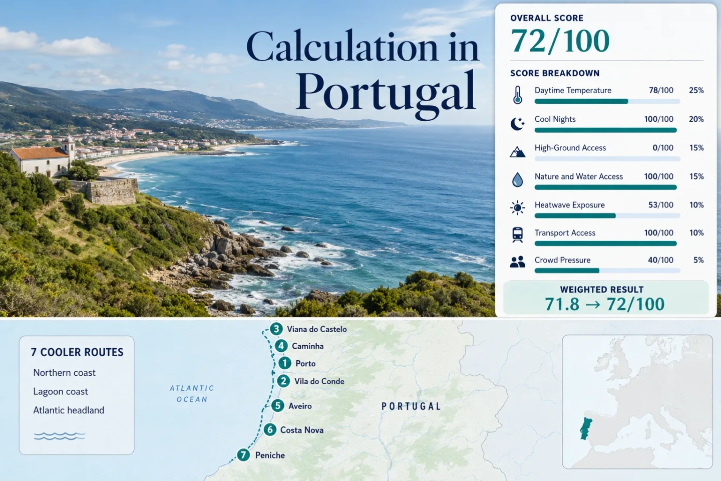
The route set follows the Minho coast, Porto’s metro corridor, the Aveiro lagoon and the exposed Peniche peninsula.
Cabo Carvoeiro’s July–August mean daily maximum is markedly lower than the northern estuary stations used elsewhere in the comparison.
Metro do Porto and the Minho Line connect four route bases without requiring a rental car for the main town-to-town movement.
A direct rail base and a local bus connection link sheltered lagoon streets with the more wind-exposed Atlantic beach edge.
Exposed coasts can remain mild while producing strong afternoon wind, cool water and rapid changes between sheltered streets and open beaches.
Atlantic Cities, Estuaries and Coastal Planning Centers
The markers follow a north-to-south coastal sequence rather than a single driving itinerary. Porto, Vila do Conde, Viana do Castelo and Caminha form the strongest rail-connected northern chain; Aveiro and Costa Nova share a lagoon system; Peniche provides the most exposed headland climate.
Markers show selected cooler-route regions and planning centers, not guaranteed legal parking, trailheads or exact viewpoints. Use the destination links and current local access information before traveling.
Portugal Atlantic Cooler Escape Suitability Score
This transparent editorial suitability index uses disclosed climate, landscape, access and pressure factors for the seven mapped routes. It is not an official climate classification or a weather forecast.
Weighted total: 78×0.25 + 100×0.20 + 0×0.15 + 100×0.15 + 53×0.10 + 100×0.10 + 40×0.05 = 71.8 → 72/100
Method: Route count does not add bonus points. Route-level values are combined using the median before the seven fixed weights are applied. Comparability quality is limited by the older Viana do Castelo normal and the use of shared representative stations for nearby coastal routes.
Northern Cities, Lagoon Streets and Exposed Ocean Bases
The seven bases separate into three practical groups: the Porto–Minho public-transport corridor, the Aveiro lagoon pair and the exposed Peniche headland. Their temperature normals are useful for comparison, but local wind exposure, urban shade and distance from the immediate shoreline can change the feel of the same day.
Porto and the Douro–Atlantic Edge
Porto offers the strongest full-service city base in the route set. The IPMA station at Pedras Rubras records a July–August mean maximum of 24.55°C and a mean minimum of 15.60°C. The historic center sits inland from the immediate ocean edge, so Ribeira and steep sheltered streets can feel warmer than Foz do Douro or Matosinhos during a sunny afternoon.
The cooling advantage is flexible movement: Metro, suburban rail and urban buses make it possible to shift between the central city, the Douro mouth and open Atlantic beaches without rebuilding the itinerary around a car.
Vila do Conde at the Ave River Mouth
Vila do Conde replaces Porto’s steep urban density with a flatter river-and-beach layout. Metro Line B provides direct access from the Porto network, and the town center lies close to both the Ave estuary and the Atlantic shoreline.
The Porto/Pedras Rubras station is used as the representative climate source because it is approximately 15 km southeast within the same broad coastal climatic region. Its 24.55°C daytime and 15.60°C night normals indicate a mild maritime base, although the open beach can be substantially windier than the protected streets near the river.
Viana do Castelo Between the Lima and Santa Luzia
Viana do Castelo combines a walkable historic center, the Lima River, Atlantic beaches and immediate visual relief at Santa Luzia. The direct station record is older than the other main climate sources, covering 1971–2000, but it remains useful as a disclosed local reference.
The July–August mean maximum is 26.0°C, warmer than Porto, Aveiro and Peniche in this comparison. Nights average about 14.85°C, providing stronger overnight relief than the daytime figure suggests. Serra d’Arga also gives the Viana–Caminha pair the only meaningful high-ground access in the route set.
Caminha, Moledo and the Minho Estuary
Caminha sits where the Minho River reaches the Atlantic, while Moledo adds an open-ocean beach station on the same rail corridor. The combination supports a car-light trip with two different exposure patterns: more sheltered estuary streets in Caminha and stronger wind at Moledo.
Viana do Castelo station is used as the representative official climate source, approximately 20–25 km south in a similarly low northern coastal setting. That produces a 26.0°C July–August daytime value and 14.85°C night value for scoring, with comparability reduced by distance and the older 1971–2000 period.
Aveiro as the Ria de Aveiro Transport Base
Aveiro works as a transport-oriented base rather than an immediate ocean town. The IPMA station at the university lies at 3.6 m elevation and records a July–August mean maximum of 24.25°C and a mean minimum of 16.40°C.
The lagoon moderates the setting, but the compact canal center can become busy and sun-exposed. The strategic advantage is the combination of direct rail with local bus access to Barra and Costa Nova, allowing a shift from urban shelter to open beach wind during the same stay.
Costa Nova Between the Lagoon and Open Atlantic
Costa Nova occupies a narrow strip between the Ria de Aveiro and the Atlantic. That geography gives it two distinct micro-settings within a short walk: a more protected lagoon-facing settlement and a more exposed ocean beach.
The Aveiro/Universidade station, approximately 11 km east on the same low coastal plain, supplies the 24.25°C daytime and 16.40°C night scoring values. Local afternoon wind may create a cooler sensation than the station temperature alone suggests, while sheltered streets can retain more warmth.
Peniche and the Cabo Carvoeiro Headland
Peniche has the clearest low-daytime-temperature signal in the route set. Cabo Carvoeiro/Farol records a July–August mean maximum of 20.85°C, nearly four degrees lower than the seven-route median, and only 0.2 average days at or above 30°C across the two-month period.
The trade-off is exposure. Wind, fog patches and cool ocean water can make the peninsula feel much less summery than inland Portugal, while the 17.05°C night normal is slightly warmer than the northern route nights. Peniche also lacks rail access, although direct coaches keep it viable without a car.
How the Minho Line Changes a Northern Coastal Stay
Porto, Viana do Castelo and Caminha are not isolated coastal stops. They sit on a continuous rail corridor extending north toward Valença and Vigo, while Vila do Conde is reached through Metro do Porto’s Line B. That structure makes route selection less dependent on a single hotel base or a long coastal drive.
Porto as the Network Hub
Porto supplies long-distance rail, airport metro and the largest accommodation range. A cooler-day strategy can use the city for arrival and departure while assigning more exposed coastal time to Vila do Conde or a Minho Line town.
Viana Services, Caminha Exposure
Viana provides a larger urban base and immediate local relief at Santa Luzia. Caminha and Moledo trade some services for a more open estuary-and-beach setting, with direct rail preserving a car-light itinerary.
Vila do Conde Without a Rail Transfer
Metro Line B links central Porto with Vila do Conde through one urban transit system. It is the simplest way to add a flatter Atlantic town without moving into regional rail planning or renting a vehicle.
Why Aveiro and Costa Nova Can Feel Different on the Same Day
Ria de Aveiro Shelter
Aveiro’s center lies inland from the ocean behind the lagoon system. Buildings, canals and lower wind exposure can make the city feel warmer than the coast even though the same official station represents both route scores.
The city is stronger for rail access, restaurants and evening services. It is weaker when the main objective is sustained exposure to Atlantic wind.
Costa Nova Wind Exposure
Costa Nova’s narrow geography places the lagoon and ocean within walking distance. Afternoon nortada can reduce perceived warmth on the beach side, while the lagoon-facing streets provide a more protected fallback.
The cooler-feeling location is not automatically the calmer location. Strong wind can affect beach comfort, cycling and outdoor dining even when air temperature remains moderate.
Daytime Heat, Night Relief and Car-Light Access
The climate figures use the disclosed official station assignments rather than an undifferentiated national average. The transport column describes the main arrival pattern, while the final column identifies the trade-off most likely to affect a summer decision.
| Route | July–August Mean Maximum | July–August Mean Minimum | 30°C+ Frequency | Primary Public Transport | Main Trade-Off |
|---|---|---|---|---|---|
| Porto | 24.55°C | 15.60°C | 6.6 days per 62-day normal window | National rail, metro and urban transit | Dense central streets can feel warmer than the ocean edge |
| Vila do Conde | 24.55°C | 15.60°C | 6.6 days using Porto/Pedras Rubras | Metro do Porto Line B | Flat terrain leaves no meaningful altitude fallback |
| Viana do Castelo | 26.00°C | 14.85°C | 11.9 days in the 1971–2000 normal | CP Minho Line | Warmer daytime normal but stronger night cooling |
| Caminha and Moledo | 26.00°C | 14.85°C | 11.9 days using Viana station | CP Minho Line | Representative station is south of the route |
| Aveiro | 24.25°C | 16.40°C | 4.3 days per 62-day normal window | Mainline rail | Lagoon city center is less wind-exposed than the beach |
| Costa Nova | 24.25°C | 16.40°C | 4.3 days using Aveiro station | Busway from Aveiro | Strong wind and seasonal road or parking pressure |
| Peniche | 20.85°C | 17.05°C | 0.2 days per 62-day normal window | Intercity coach | Lowest daytime heat but the most exposed marine conditions |
When Peniche Becomes the Clear Low-Heat Choice
Peniche is the strongest route when the decision is based narrowly on daytime temperature and 30°C exposure. Its 20.85°C July–August mean maximum is lower than every other route value, while the published threshold frequency is only 0.2 hot days across the two-month normal window.
That advantage should not be confused with universally comfortable beach weather. The same headland exposure that limits daytime heat also produces strong wind, cool water and occasional low cloud. Porto remains stronger for city services, the Minho corridor is stronger for rail-linked multi-stop travel, and Aveiro is stronger for combining mainline rail with lagoon access.
Peniche becomes the clearest choice when avoiding hot afternoons matters more than warm swimming water, sheltered promenades or high-ground access.
Nortada, Ocean Temperature and Same-Day Coastal Checks
The west coast’s summer nortada commonly strengthens during the afternoon, so a route that appears mild on a temperature forecast may still become difficult for an exposed beach day. Morning hours can provide calmer conditions in Costa Nova, Moledo and Peniche, while sheltered estuary or lagoon streets remain useful later in the day.
Before departure: Check the current IPMA forecast and warnings, CP or Metro service notices, local bus timetables and municipal beach or parking information. Historical normals describe the long-term climate pattern; they do not predict wind strength, fog, wildfire smoke or an individual heat event.