Madagascar Highland Routes: Antsirabe, Granite Massifs and Cool Central Towns
Madagascar’s central and southern highlands replace much of the island’s lowland heat with elevated towns, cooler nights and mountain air. The strongest relief is found around Antsirabe and the Andringitra massif, but January–February is also the wet season: cloud, afternoon rain, damaged tracks and slow rural access can matter as much as the temperature.
The portfolio follows the RN7 highland spine and four rural or mountain diversions.
Madagascar’s warm-season window brings milder highland temperatures but frequent rain.
Published long-term values place typical daytime highs near 21–22°C across this elevated central belt.
The mountain base and higher walking circuits add altitude, exposure and rapid post-sunset cooling.
Antsirabe, Ambositra, Fianarantsoa and Ambalavao are connected by the principal southbound corridor.
Central highland records show roughly 21–30 rain days per month during the target window.
The RN7 Highland Spine and Its Mountain Detours
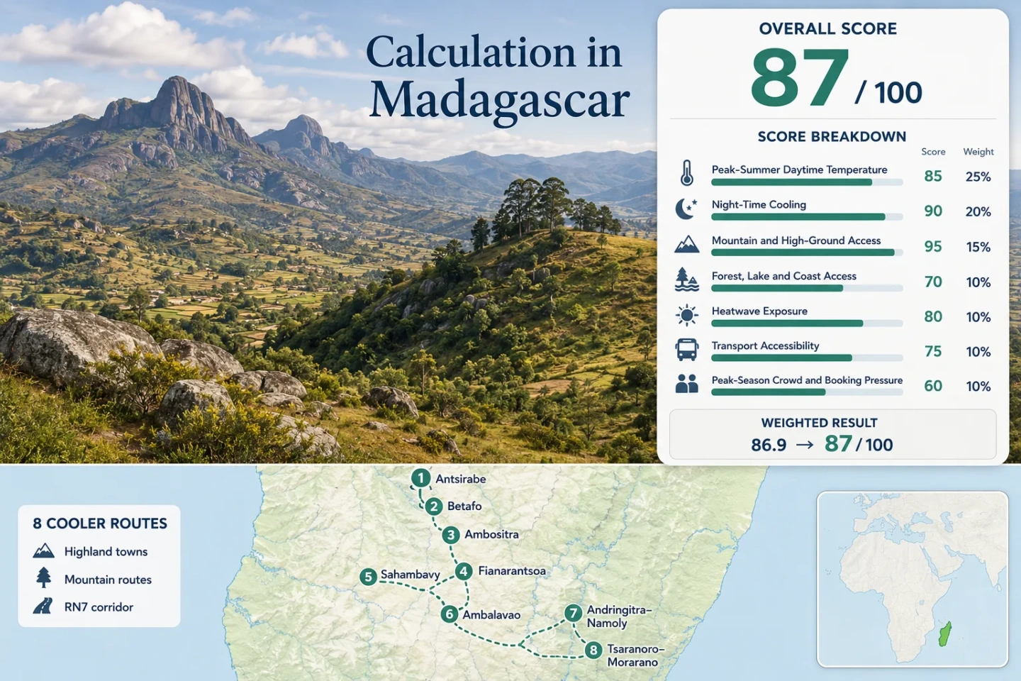
The numbered markers follow the central plateau southward from Antsirabe, then split toward Sahambavy, Namoly and the Tsaranoro side of the Andringitra massif.
Markers indicate planning centers rather than guaranteed trailheads, legal parking areas or exact viewpoints. Rural road conditions and park access should be checked locally before travel.
Madagascar Highland Cooler Escape Suitability Score
This transparent editorial suitability index uses disclosed climate, landscape, access and visitor-pressure factors. It is not an official climate classification or a weather forecast.
Weighted total: 82×0.25 + 100×0.20 + 100×0.15 + 75×0.15 + 95×0.10 + 70×0.10 + 80×0.05 = 87.3 → 87/100
Method: Route count provides no bonus. Each route carries equal weight, route-level values are combined by median and the seven fixed factors are then weighted.
Plateau Towns, Lake Country and Granite Valleys
The northern routes emphasize dependable town access and low daytime temperatures. South of Fianarantsoa, the portfolio becomes warmer, more exposed and increasingly dependent on rural tracks.
Antsirabe
Approximate base elevation: 1,500 m. January–February averages are about 21.5°C by day and 14.0°C at night, giving Antsirabe the clearest balance between cool-town conditions and practical services.
Rain is the main compromise: the published series records about 295 mm in January and 229 mm in February, with precipitation on most days. Short showers and persistent cloud are more likely to alter plans than extreme heat.
Betafo
Betafo lies roughly 20 km west of Antsirabe at an approximate elevation near 1,400 m. The Antsirabe climate series is the closest practical representative, indicating around 21.5°C daytime and 14.0°C night-time conditions in the target window.
The lower building density and surrounding agricultural plateau create a quieter overnight setting, while open fields receive more direct solar exposure than shaded town streets.
Ambositra–Antoetra
Ambositra sits near 1,280 m and has published January–February averages close to 21.5°C by day and 14.0°C at night. Antoetra, about 40 km farther into the Zafimaniry uplands, adds hillier terrain and a slower final approach.
January rainfall is listed near 295 mm, falling to roughly 229 mm in February. Cloud and fog can suppress daytime heat while reducing visibility on the hill road.
Fianarantsoa
Fianarantsoa spreads across sloping terrain at approximately 1,200 m. Its January–February climate is warmer than Antsirabe, averaging about 24.1°C by day and 16.6°C at night.
January brings around 259 mm of rain and 28.7 rain days in the published series. Upper, exposed districts and dense lower streets can feel different during the same afternoon, especially when cloud breaks allow short periods of strong sun.
Sahambavy
Sahambavy combines an elevated lake setting, tea-growing land and lower development density east of Fianarantsoa. The representative Fianarantsoa values are about 24.1°C by day and 16.6°C at night for January–February.
Water moderates the daily rhythm rather than guaranteeing colder air. Mornings can be cloudy and mild, open tea fields receive direct midday sun and the lakeside atmosphere may feel more humid than Antsirabe’s plateau.
Access requires a diversion from Fianarantsoa, so an overnight visit is more resilient than a tightly timed same-day excursion during the wet season.
Ambalavao
At roughly 1,000 m, Ambalavao marks the point where the cool central plateau begins to transition toward sunnier southern interior conditions. Representative January–February values approach 27.8°C by day and 19.0°C at night.
Its RN7 position makes it valuable for supplies and onward transport. The city is also the practical branching area for the Namoly and Tsaranoro approaches, where journey quality depends on rain, track damage and vehicle clearance.
Andringitra–Namoly
Mountain-base elevation is approximately 1,400 m, with walking routes rising much higher toward exposed ridges and the Imarivolanitra area. The elevation-adjusted January–February proxy is about 24.5°C by day and 15.5°C at night at the lower route base.
Madagascar National Parks describes a 47 km approach track from the RN7 side to Namoly and recommends an off-road vehicle, particularly in the rainy season. The route therefore combines the portfolio’s strongest mountain cooling with its largest access penalty.
Tsaranoro–Morarano
The Tsaranoro side lies beneath the Andringitra massif but outside the national park boundary. Morarano access involves a rural track of roughly 60 km from the RN7 approach described by Madagascar National Parks.
The lower valley’s estimated January–February pattern is about 26.0°C by day and 17.5°C at night. Exposed granite can make direct-sun conditions feel much warmer than the air temperature suggests, while clear periods after sunset can produce noticeable cooling.
Why Tsaranoro’s Granite Can Override Its Elevation
Air temperature, rock-surface temperature and thermal comfort are not interchangeable in an exposed granite valley.
Direct-Sun Heating
Bare rock receives intense solar radiation when wet-season cloud breaks. The surrounding air may remain below 30°C while exposed walking surfaces and walls become substantially warmer.
Valley Shade Timing
Morning and afternoon shade depend on wall orientation. A route beneath a shaded face can feel markedly cooler than an open valley floor only a short distance away.
Post-Sunset Cooling
Clearer intervals allow heat to escape after sunset, while wind descending from higher terrain increases cooling. Humid, cloudy nights reduce that advantage.
Practical distinction: Andringitra–Namoly is the stronger choice for sustained high-ground cooling. Tsaranoro–Morarano is more dependent on shade, wind and the timing of outdoor activity.
Where the RN7 Ends and the Access Penalty Begins
The principal highland cities are connected by RN7, but the mountain extensions should be planned as separate transport stages rather than short add-ons.
RN7 Town Bases
Antsirabe, Ambositra, Fianarantsoa and Ambalavao support intercity travel, supplies and more accommodation choice. Delays still occur, but a capable mountain vehicle is not normally the defining requirement for reaching the town center.
Short Rural Diversions
Betafo, Antoetra and Sahambavy replace direct corridor access with local roads, fewer departures and less recovery capacity when a vehicle or timetable fails.
Andringitra Approach Tracks
The official park description identifies 47 km to Namoly and 60 km to Morarano after leaving the RN7 corridor. Rainy-season off-road advice makes vehicle type more important than straight-line distance.
Do not convert map distance directly into a fixed journey time. Track condition, bridge status, recent rain, vehicle clearance and local confirmation determine whether a mountain transfer remains practical.
Which Highland Route Matches the Cooling Priority?
All eight routes are compared with the same names used on the map, score calculation and destination portfolio.
| Route | Jan–Feb Day | Jan–Feb Night | Main Cooling Mechanism | Access Pattern | Primary Trade-Off |
|---|---|---|---|---|---|
| Antsirabe | 21.5°C | 14.0°C | High plateau and reliable night cooling | Direct RN7 city access | Frequent rain and urban traffic |
| Betafo | 21.5°C proxy | 14.0°C proxy | Rural plateau and low building density | Short local-road diversion | Limited services and open-sun exposure |
| Ambositra–Antoetra | 21.5°C | 14.0°C | Elevated town plus forested uplands | RN7 followed by slower hill road | Fog, rain and branch-road condition |
| Fianarantsoa | 24.1°C | 16.6°C | Hillside elevation and cloud cover | Major RN7 regional hub | Higher humidity and warmer nights |
| Sahambavy | 24.1°C proxy | 16.6°C proxy | Lake influence and green highland setting | Rural diversion from Fianarantsoa | Humidity and less flexible transport |
| Ambalavao | 27.8°C | 19.0°C | Moderate elevation and evening cooling | Direct RN7 access | Warmer afternoons than central plateau towns |
| Andringitra–Namoly | 24.5°C proxy | 15.5°C proxy | Mountain elevation, wind and exposed high ground | 47 km approach track | Rain, road condition and limited services |
| Tsaranoro–Morarano | 26.0°C proxy | 17.5°C proxy | Night cooling beneath the granite massif | Approximately 60 km rural approach | Solar-heated rock and car dependence |
The Coolest Air and the Most Reliable Roads Occur in Different Windows
January–February tests highland performance during Madagascar’s warm season. Travelers prioritizing dry tracks or colder nights may prefer a different part of the year.
January–February: Warm-Season Relief
Antsirabe, Betafo and Ambositra remain comparatively mild while many lower parts of Madagascar are warmer. The cost is persistent rain, cloud, muddy rural roads and cyclone-related disruption.
April–May: Drier Transition
Rainfall declines sharply across the central highlands, nights become cooler and rural road reliability generally improves. This window better balances walking access with moderate daytime temperatures.
June–August: Cold-Night Priority
Central plateau nights can fall well below the January–February averages. Mountain exposure becomes more serious, especially where wind, basic lodging or early departures amplify the cold.
September–October: Sun and Warming Afternoons
Rain remains limited early in the period, but exposed granite and open plateau surfaces warm quickly. Tsaranoro’s direct-sun penalty becomes more noticeable before the main rains return.
Rain, Cyclone Bulletins and Park Access Need a Final Check
January–February sits inside Madagascar’s rainy and tropical-cyclone season. Current Météo Madagascar warnings, road reports and local park confirmation can override normal climate expectations. For Namoly and Morarano, confirm the access track, bridges, vehicle requirement and operating arrangements shortly before departure.