South Africa Mild-Season Routes: Mountain Regions, Coastal Air and Cooler Landscapes
South Africa’s January–February heat can be reduced by changing geography rather than simply moving south. Cold-current Atlantic exposure, elevated escarpment towns, Drakensberg bases and the forest-and-lake corridor of the Garden Route create distinct mild-season patterns. The strongest trade-offs are equally clear: Cape wind, warmer nights on the far southern coast, summer thunderstorms in the highlands, long road transfers and holiday pressure on national routes.
Three coastal systems, one forested mountain village and four highland or Drakensberg bases form the common assessment set.
The score uses South Africa’s core summer period rather than the cooler winter months.
The route median is moderated by the southern coast and elevated eastern bases, but inland heat bursts remain possible.
Highveld and Drakensberg nights provide the clearest sleep-time relief in the portfolio.
Marine exposure lowers typical daytime heat, although the route’s 18.4°C mean minimum produces milder nights.
The route set spans low coastal bases and high Drakensberg accommodation, allowing major temperature shifts within one country.
Table Mountain closures, afternoon convection and late-holiday N3 traffic can change a workable plan quickly.
Cape Coasts, Amathole Forests and Drakensberg Bases
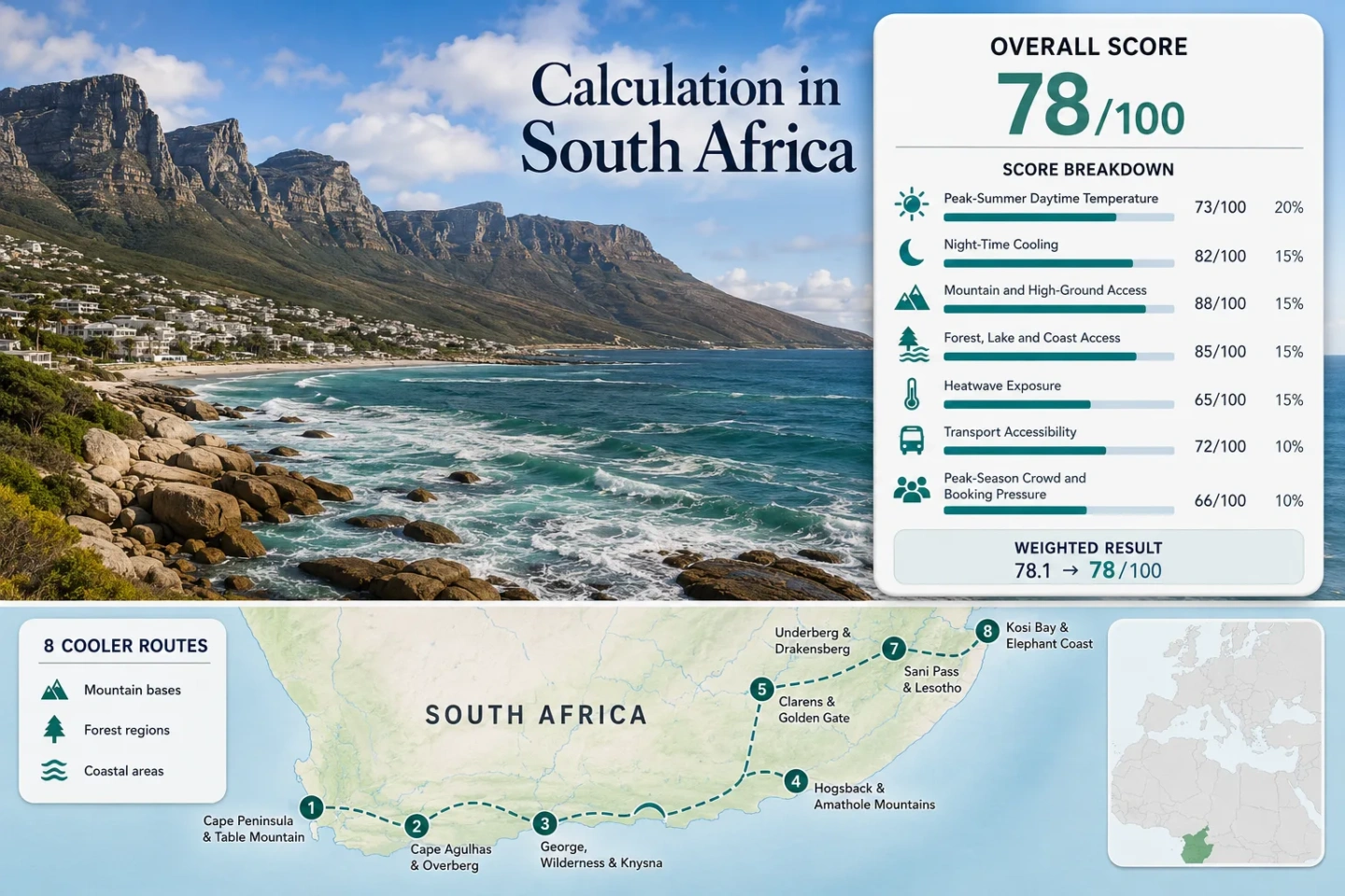
The markers connect Atlantic and southern-coast moderation with elevated Free State, KwaZulu-Natal and Eastern Cape bases. Marker numbers match the eight route cards immediately after the suitability score.
This marker map is built for planning orientation. Marker positions use approximate public location centres where exact viewpoints, trailheads, legal parking areas or pull-offs are not specified. Markers show selected route regions rather than guaranteed parking or navigation points; use each route card for Google Maps links and current access checks.
South Africa Mild-Season Route Suitability Score
This transparent editorial suitability index uses disclosed climate, landscape, access and pressure factors for the eight displayed routes. It is not an official climate classification or a weather forecast.
Weighted total: 67×0.25 + 100×0.20 + 100×0.15 + 100×0.15 + 63×0.10 + 60×0.10 + 60×0.05 = 82.1 → 82/100
Southern Coasts, Escarpment Towns and Drakensberg Valleys
The route set separates three different ways to reduce summer heat: marine moderation, high-elevation night cooling and forested mountain shade. No route removes weather risk; each shifts the balance between daytime temperature, overnight relief, access and holiday pressure.
Cape Peninsula and Table Mountain
Cape Town International’s January–February baseline is 28.0°C by day and 16.3°C at night, while Table Mountain rises to about 1,085 m above the low urban and coastal base. That vertical shift is the route’s main advantage: the same day can move from warm city streets to wind-exposed high ground. The 2016–2025 station series recorded 149 days at or above 30°C among 567 valid target-window days, so Atlantic exposure does not eliminate heat bursts.
Cape Agulhas and the Overberg Coast
Cape Agulhas provides the lowest route-level daytime normal in the set at 24.6°C. Its 18.4°C mean minimum is also the warmest night figure, showing the classic marine trade-off: lower afternoon heat but less dramatic overnight cooling. Only 2 of 556 valid January–February days reached 30°C in the 2016–2025 station record. The low coastal plain offers little altitude relief, so the route depends on persistent ocean exposure rather than a mountain escape.
George, Wilderness and Knysna
George Airport records 25.7°C mean daytime maxima and 15.4°C mean minima for January–February. The 2016–2025 hot-day count is 41 of 565 valid days, or 7.3%. George supplies the airport and inland service base; Wilderness adds lakes, estuary and beach access; Knysna adds lagoon and forest edges. Typical road transfers between the three bases are short enough to change exposure during the day, but the distributed layout makes a rental car more useful than the airport alone suggests.
Hogsback and the Amathole Mountains
Hogsback’s village base sits near 1,200 m among forested Amathole slopes. The representative Dohne station is about 50 km away and roughly 300 m lower, with a 28.7°C mean high, 14.4°C mean low and 206 hot days among 516 valid target-window days. That 39.9% value should not be read as the village’s exact hot-day rate; it shows why elevation and shade matter more here than the regional lowland signal. Warm afternoons and summer convection remain possible even when nights cool sharply.
Clarens and Golden Gate Highlands
Clarens sits around 1,850 m, while the Bethlehem representative station lies about 31 km away at 1,695 m. Its January–February normals are 27.3°C by day and 13.2°C at night; 102 of 541 valid target-window days reached 30°C during 2016–2025. The route therefore works through night cooling and rapid highland access, not guaranteed cold afternoons. Golden Gate’s 28 km Ribbok Hiking Trail and shorter sandstone routes expand the high-ground portfolio, but exposed terrain needs early starts in storm-prone summer weather.
Witsieshoek and Royal Natal
Witsieshoek’s accommodation base is near 2,200 m, the highest sleeping elevation in the set. Van Reenen is used as the representative station about 50 km away and roughly 520 m lower, with 25.8°C mean highs, 13.5°C mean lows and a hot-day rate of 8.0% from 486 valid days. The station therefore understates the route’s elevation while still showing useful regional night relief. Royal Natal’s summer gate hours of 06:00–18:00 favour early trail starts and make late-afternoon improvisation less practical.
Didima and Cathedral Peak
Didima’s resort base is near 1,400 m, with rapid access into higher Cathedral Peak terrain. Van Reenen supplies the representative 25.8°C high, 13.5°C low and 8.0% hot-day rate, but it lies about 66 km away and roughly 280 m higher than the resort base. The route is open year-round and the official accommodation information identifies sedan access, while summer gate hours run 06:00–18:00. This is a mountain-valley compromise: easier resort logistics than a very high base, but warmer afternoons than Witsieshoek.
Van Reenen, Harrismith and Platberg
Van Reenen’s station sits around 1,680 m and records 25.8°C mean January–February highs, 13.5°C mean lows and 39 hot days among 486 valid days, or 8.0%. Harrismith, roughly 30 km away, provides the stronger service base and access toward Platberg. The N3 makes arrival simple, yet the same corridor brings a different planning problem: holiday traffic, roadworks, mist, low cloud and gusty wind can turn a short transfer into the route’s main uncertainty.
Benguela Air, Agulhas Water and the Garden Route Transition
South Africa’s southern coastline does not behave as one continuous mild zone. The cold Atlantic side, the Agulhas meeting-point coast and the greener Garden Route produce different combinations of daytime relief, wind, humidity and night temperature.
Cape Peninsula: Cooler Air With a Wind Trade-Off
The Cape Peninsula combines marine exposure with a rapid 1,085 m vertical move, but its 28.0°C station normal and 26.3% hot-day rate show that the city base can still heat up. The strongest relief often comes from exposure change: west-facing coast, shaded mountain slopes or higher ground. The price is operational fragility when wind or cloud closes the cableway.
Cape Agulhas: Lower Afternoons, Milder Nights
The 24.6°C daytime normal and 0.4% hot-day rate make Cape Agulhas the clearest low-heat coastal reading in the set. The 18.4°C mean minimum is less useful for travelers seeking cold sleep conditions. It is a route for steady moderation, not a dramatic day-to-night temperature drop.
Garden Route: Forest, Lakes and Airport Practicality
George’s 25.7°C/15.4°C profile sits between the Cape and the highlands. Wilderness and Knysna add water and forest access within a compact N2 corridor. Humidity and rainfall can make a moderate temperature feel heavier, but the mix of airport access, shaded landscapes and multiple town bases gives the route the broadest coastal fallback system.
Table Mountain Wind, Drakensberg Storms and Day-Plan Timing
Cape Town Needs a Downhill Backup
SANParks warns that rapid weather changes can shut the Table Mountain cableway unexpectedly. A plan that assumes an assisted descent is weaker than one with enough daylight, water and fitness for a walking alternative. On warm, calm mornings, the high ground may be the mildest part of the day; by afternoon, wind and cloud can become the limiting factor rather than temperature.
Drakensberg Routes Reward Early Starts
Royal Natal and Didima publish 06:00–18:00 summer gate hours, while summer convection can build after a clear morning. Witsieshoek, Didima and Golden Gate therefore work most reliably when longer objectives begin early, exposed ridges are crossed before afternoon instability and a shorter valley or forest option remains available.
Where a Rental Car Changes the Route
Cape Peninsula: Car-Light Until the Mountain Link Breaks
Cape Town has the strongest public-transport and ride-service ecosystem in the set, but the direct Table Mountain shuttle status can change. A city stay can remain car-light; a peninsula-wide plan involving Cape Point, Silvermine and dispersed trailheads becomes substantially easier with a vehicle or pre-booked transfer.
George Airport: Strong Arrival, Distributed Daily Travel
George Airport puts Wilderness, George and Knysna into one practical arrival zone. The cooling landscapes are spread across lakes, beaches, forests and estuaries, so a car converts a single airport base into a flexible weather-response corridor. Without one, each change of exposure requires more timetable dependence.
Drakensberg: The Final Transfer Controls the Day
Clarens, Witsieshoek, Didima and Van Reenen are reachable by major road networks, yet trailheads, resort gates and highland viewpoints remain dispersed. The last 30–90 minutes often determine whether an itinerary can respond to storms, gate times and cloud. A private vehicle is less about arrival and more about preserving options once conditions change.
Eight Routes Compared by Heat, Height and Access
The same eight routes used by the map and score are compared here. Temperature values are representative January–February station normals; elevation descriptions refer to the practical route base or its defining vertical move.
| Route | Station high / low | Base or vertical move | Cooling mechanism | Access structure | Main summer risk |
|---|---|---|---|---|---|
| Cape Peninsula and Table Mountain | 28.0°C / 16.3°C | Low coast to about 1,085 m | Atlantic exposure plus rapid ascent | Major airport and city transport; mountain link status must be checked | Heat bursts, strong wind, cableway closure and parking pressure |
| Cape Agulhas and the Overberg Coast | 24.6°C / 18.4°C | Low coastal plain | Persistent marine moderation | Road-led route; limited practical public transport | Wind, exposed coast and milder nights |
| George, Wilderness and Knysna | 25.7°C / 15.4°C | Low coast with nearby Outeniqua high ground | Ocean, lakes, estuary and forest shade | George Airport plus short N2 transfers; car useful | Humidity, rain and concentrated holiday demand |
| Hogsback and the Amathole Mountains | 28.7°C / 14.4°C representative | Village around 1,200 m | Altitude, forest shade and night cooling | Private-car approach with limited car-light alternatives | Regional heat bursts and afternoon thunderstorms |
| Clarens and Golden Gate Highlands | 27.3°C / 13.2°C | Clarens around 1,850 m | Highveld night cooling and elevated trails | Road access from regional hubs; vehicle needed in the park | Exposed midday heat, lightning and holiday weekends |
| Witsieshoek and Royal Natal | 25.8°C / 13.5°C representative | Accommodation around 2,200 m | Very high sleeping base and montane exposure | Road-dependent final transfer; 06:00–18:00 Royal Natal summer gate | Lightning, low cloud, wind and long trail commitments |
| Didima and Cathedral Peak | 25.8°C / 13.5°C representative | Resort near 1,400 m with higher terrain close by | Valley shade, river corridors and mountain ascent | Sedan-accessible resort; 06:00–18:00 summer gate | Warmer valley afternoons and storm-timed hiking |
| Van Reenen, Harrismith and Platberg | 25.8°C / 13.5°C | Pass and station around 1,680 m | Escarpment altitude and night cooling | Direct N3 corridor with Harrismith services | Mist, gusts, roadworks and holiday traffic |
Late-December Pressure, February Heat and the March Shoulder
Late December to Mid-January
Coastal accommodation, Cape attractions, the Garden Route and N3 return traffic face their strongest combined pressure. The weather can still support mild coastal days or cool highland nights, but booking flexibility and transfer timing are at their weakest. This period rewards fixed reservations and conservative road-day assumptions.
Late January Through February
Holiday pressure often eases before the core summer heat signal disappears. Cape Peninsula heat bursts, Free State warm afternoons and Drakensberg storms remain relevant. Cape Agulhas retains the strongest low-heat coastal profile, while Witsieshoek, Didima and Clarens retain the strongest night-cooling advantage.
March and April
The shoulder period can reduce crowd pressure and soften inland daytime heat, while many park and road systems remain operational. Daylight shortens and coastal weather becomes less uniformly summery, but the balance improves for travelers who value hiking temperatures, flexible bookings and quieter town bases more than swimming conditions.