Malawi Highland Escapes: Nyika Plateau, Tea Country and Lake Breezes
Malawi’s cool-season relief is not one climate. Nyika’s 2,000-metre-plus plateau can deliver genuinely cold mornings; Viphya, Zomba, Thyolo and Mulanje soften daytime heat through elevation, forest cover and dry-season nights; the northern lakeshore stays warmer and relies on moving air rather than altitude. June and July create the clearest contrast, while rough park roads, Mwera winds and room orientation can matter as much as the destination name.
The official Nyika station elevation explains why this route produces the strongest night cooling.
Thyolo’s mildness is tied to highland elevation and shade, not simply to the presence of tea fields.
The dry-season cold period gives the clearest separation between plateau, tea-country and lakeshore conditions.
Nyika cools through elevation, southern highlands moderate heat, and Lake Malawi supplies time-dependent relief.
Strong south-easterly winds can improve thermal relief while making boating and exposed shoreline conditions rougher.
Eight equally weighted routes are assessed; route count creates no score bonus.
From Chelinda Grasslands to the Northern Lakeshore
The marker set follows the same eight places used in the score and route comparison. Plateau markers represent planning centres rather than exact trailheads, viewpoints or legal parking areas.
This marker map is built for planning orientation. Marker positions use approximate public location centres where exact viewpoints, trailheads, legal parking areas or pull-offs are not specified. Use each route card for Google Maps links and access notes before travelling.
Malawi Highland and Lakeshore Suitability Score
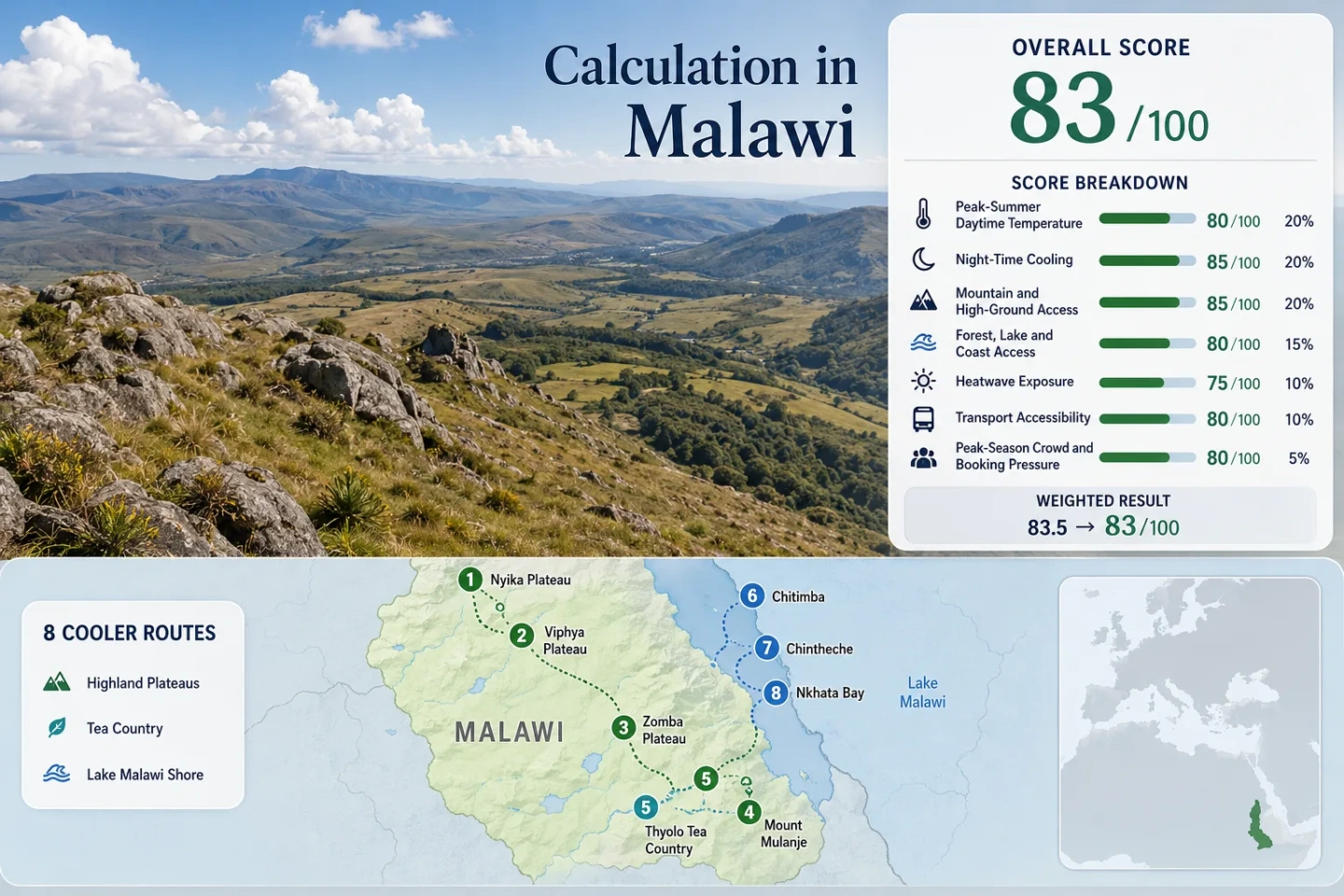
This is a transparent editorial suitability index based on disclosed climate, landscape, access and pressure factors. It is not an official climate classification or a weather forecast.
Weighted total: 86×0.25 + 100×0.20 + 90×0.15 + 75×0.15 + 94×0.10 + 70×0.10 + 80×0.05 = 86.7 → 87/100
Method: Route count does not add bonus points. Each route carries equal weight, route-level values are combined with the median, and the seven fixed factor weights are then applied. The C comparability grade reflects mixed normal periods and proxy use rather than missing factors.
Plateau Bases, Tea Slopes and Lake-Facing Stops
The route order moves from the strongest altitude signal to warmer water-based relief. Lake stops remain valuable, but their comfort depends more heavily on airflow, humidity and building position.
Nyika Plateau
Chelinda sits at 2,296 m in the DCCMS station network, making Nyika the route with the clearest altitude-led temperature relief. A June–July planning climatology of about 19.0°C by day and 8.0°C at night places warm layers, wind protection and UV protection in the same packing list.
Viphya Plateau
The Chikangawa station stands at 1,726 m, while Luwawa’s forest setting adds shade and wind shelter that Nyika’s exposed grasslands do not provide. The route-planning values are about 22.0°C for daytime maxima and 10.5°C for night minima in June–July.
Official tourism information places Luwawa roughly 8 km east of the M1 on an all-weather dirt road. That makes Viphya less isolated than Chelinda but still better suited to a planned road transfer than an improvised public-transport stop.
Zomba Plateau
Zomba combines a serviceable city base with a plateau rising to about 2,087 m. The representative low-base station sits much lower, so the 23.2°C daytime and 13.5°C night proxies describe the practical mixed route rather than the coldest summit-edge conditions.
Useful for a shorter southern highland break where restaurants and road connections matter alongside forest shade.
Mount Mulanje
The DCCMS Mulanje AWS is at 649 m, but the massif rises to around 3,000 m and contains numerous summits above 2,500 m. That vertical range is the route’s defining measure: a foothill stay may average roughly 23.5°C by day and 13.0°C at night in June–July, while a high hiking day can be substantially colder and windier.
Watch for: Cloud, wet rock and route-finding conditions can matter even in the drier season. Hut, guide and trail arrangements require current local confirmation.
Thyolo Tea Country
Tea has been grown around Thyolo since 1908, and the Bvumbwe station’s 1,145 m elevation explains more of the mildness than the green appearance alone. June–July planning values near 23.5°C by day and 13.5°C at night suit early walks and shaded estate stays.
Chitimba and Northern Lakeshore
Chitimba places Lake Malawi directly below the Rift Valley escarpment. The lakeshore base remains much warmer than Nyika, with a planning climatology around 24.5°C by day, yet nights near 11.0°C can be noticeably cooler when dry-season air drains from higher ground.
The nearby ascent toward Livingstonia adds altitude potential, but the road is a separate access decision rather than an automatic extension of a beach stay. Mwera winds can also strengthen lake conditions from May to August.
Chintheche
The official Chintheche station is at 500 m. June–July planning values around 25.5°C by day and 16.5°C at night make it a water-and-airflow stop rather than a cold-climate base.
Road access from Mzuzu is simpler than the Nyika approach, but local transfers and accommodation availability still shape a car-light itinerary.
Nkhata Bay
Nkhata Bay’s long-running DCCMS station is also at 500 m. The June–July route proxy is approximately 25.4°C by day and 14.9°C at night, but the sheltered harbour can reduce airflow compared with an exposed northern beach.
Regular road access from Mzuzu and the port function improve transport flexibility. The Ilala’s weekly lake service can add a water connection, although timetable confirmation is essential.
Why Nyika and Thyolo Are Not the Same Kind of Cool
The two headline highlands solve heat in different ways. Treating them as interchangeable would hide the largest planning trade-off on the route.
Nyika Loses Heat Through Elevation and Exposure
Chelinda’s 2,296 m station sits more than 1,100 m above Bvumbwe. Open montane grassland allows wind and night-time radiative cooling to work with altitude, producing cold mornings that can require a fleece, warm sleep layer and windproof shell.
The trade-off is access. A stronger cooling mechanism comes with a remote road, fewer fallback services and weather-sensitive movement inside the park.
Thyolo Moderates Heat Rather Than Replacing It
Bvumbwe’s 1,145 m elevation, tree cover and damp soils soften daytime heat, particularly in the morning and evening. The result is milder than nearby lowlands but not alpine, and humid air can reduce the comfort gained from a lower thermometer reading.
Estate accommodation also varies by slope, shade and room ventilation. A tea-country address is not a uniform microclimate.
Mulanje Adds a Vertical Climate Split
The Mulanje AWS lies at 649 m while the massif approaches 3,000 m. A foothill room, a forest walk and a high route can occupy different thermal bands on the same day. Hiking plans therefore need a separate mountain forecast rather than a town forecast carried uphill.
Lake Malawi Breeze Changes with Shore Geometry
Lake air is a time-dependent comfort mechanism, not proof of a cool climate. Land heats faster than water during the day, helping air move inland from the lake, but the strength and timing change with cloud, pressure, shoreline exposure and local topography.
Chintheche Favours Open-Water Exposure
Open northern beaches have a clearer path for afternoon airflow. A lake-facing room with cross-ventilation can therefore outperform a more enclosed building, even though station temperatures remain warmer than the plateaus.
Nkhata Bay Trades Wind for Shelter
The harbour shape protects boats and settlement areas but can reduce the direct breeze felt at some properties. Hillside position, vegetation and whether a room faces open water become practical selection criteria.
Chitimba Couples Lake Air with Downslope Cooling
The Rift escarpment rises close to the shore. Dry-season air draining from higher ground can strengthen evening relief, while the steep road toward Livingstonia creates a separate high-ground option with different access demands.
The Long Transfer Between Nyika and Tea Country
Nyika and Thyolo belong to different route clusters. Nyika pairs naturally with Rumphi, Mzuzu, Chitimba, Chintheche or Nkhata Bay; Thyolo pairs with Blantyre, Mulanje and Zomba. Combining both clusters creates a national traverse rather than one continuous highland corridor.
Nyika to the Northern Lakeshore
The climatic sequence runs from cold plateau mornings to warmer water-based recovery. Chitimba offers the clearest escarpment link, while Chintheche and Nkhata Bay provide easier lake services and a wider choice of stays.
Decision point: Keep the lakeshore stop for swimming and airflow, not as a second Nyika-level cold base.
Zomba, Thyolo and Mulanje
Zomba supplies a serviceable plateau city, Thyolo adds shaded agricultural highlands, and Mulanje adds the largest vertical range. Blantyre functions as the transport hinge, but the coolest activity may still require a local road or mountain transfer.
Decision point: A short southern trip gains more from choosing one highland base carefully than from adding a distant northern detour.
Eight Routes Compared by Cooling Mechanism and Access
The same eight places used by the marker map and score are retained. Temperature values are route-planning climatology proxies, while elevation and access notes distinguish the official station or physical route context.
| Route | Elevation logic | June–July day / night proxy | Vehicle dependence | Primary cooling mechanism | Main trade-off |
|---|---|---|---|---|---|
| Nyika Plateau | Chelinda station 2,296 m | 19.0°C / 8.0°C | High | Altitude, open plateau and night heat loss | Remote road and cold exposure |
| Viphya Plateau | Chikangawa station 1,726 m | 22.0°C / 10.5°C | Moderate | Elevation plus forest shade | Dirt-road approach from the M1 |
| Zomba Plateau | City base below a plateau near 2,087 m | 23.2°C / 13.5°C | Low to moderate | Daily ascent, forest and elevation | Base and plateau forecasts differ |
| Mount Mulanje | 649 m station below a massif near 3,000 m | 23.5°C / 13.0°C | Moderate | Large vertical climate range | High routes need separate weather planning |
| Thyolo Tea Country | Bvumbwe station 1,145 m | 23.5°C / 13.5°C | Moderate | Highland elevation, shade and moist soils | Humidity and estate-specific access |
| Chitimba and Northern Lakeshore | Low lakeshore below a steep escarpment | 24.5°C / 11.0°C | Moderate to high | Lake airflow plus downslope evening air | Rough side-road access to high ground |
| Chintheche | Official station 500 m | 25.5°C / 16.5°C | Moderate | Open-shore lake breeze | Warm nights and room-orientation sensitivity |
| Nkhata Bay | Official station 500 m | 25.4°C / 14.9°C | Low | Lake influence and hillside airflow | Sheltered harbour can reduce direct breeze |
Cold Mornings, Mwera Winds and Green-Season Rain
June–July: Lowest-Heat Window
Nyika and Viphya deliver their strongest night-cooling advantage, while Zomba, Thyolo and Mulanje provide milder walking conditions. Lake stays are less humid than in the hot rainy season but still remain warmer than the highlands.
August–September: Drier Access, Rising Heat
Road and trail conditions can remain favourable, but daytime heat builds toward the pre-rain hot season. Lakeshore swimming may become more appealing while the plateau’s relative advantage remains important.
November–April: Green Landscapes with Access Costs
Tea country becomes greener and cloudier, Nyika road reliability can decline, and lake districts face warmer, more humid conditions. Rain can lower air temperature without improving drying conditions or sleep comfort.