Tanzania Beyond the Coastal Heat: Northern Highlands, Crater Rims and Mountain Towns
Northern Tanzania does not form one continuous cool zone. The strongest relief from coastal and lowland heat appears where roads climb onto the Arusha plateau, inhabited Kilimanjaro slopes, Karatu’s farming highlands, the Ngorongoro rim and the forested West Usambara ridges. Elevation lowers the temperature baseline, but the practical result depends on where a traveller sleeps, how far the next day descends, and whether the route relies on ordinary town services, protected-area access or a remote mountain road.
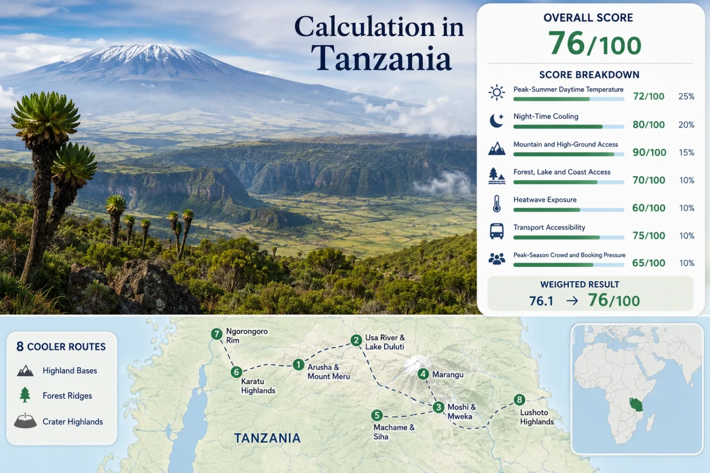
The same eight highland bases appear in the map, score calculation, route portfolio and decision matrix.
July–August mean maximum and minimum at Kilimanjaro International Airport, 891 metres, from the 1991–2020 WMO normal.
Elevation-screened July–August planning proxy across the eight route bases; it is not a set of direct town-station observations.
Rim and Nainokanoka elevations create the coldest starts in the portfolio, with wind and mist adding exposure.
The broadest urban services and transport network sit on an elevated plateau rather than on the hottest northern plains.
Karatu, crater-rim and upper-slope nights do not keep lower basins, exposed roads or central Moshi cool at midday.
From Mount Meru to the West Usambara Ridges
The route set follows three separate high-ground systems: the volcanic corridor around Mount Meru and Kilimanjaro, the Karatu–Ngorongoro rise above the Rift Valley, and the forested ridges around Lushoto. Marker positions show planning centres, not guaranteed viewpoints, legal parking areas or trailheads.
Use each route card for a place-specific Google Maps search and access notes. Mountain roads, reserve entrances and crater access points should be checked separately before travel.
Northern Tanzania Cooler Escape Suitability Score
This transparent editorial suitability index uses disclosed climate, landscape, access and pressure factors. It is not an official climate classification or a weather forecast. The score represents the eight assessed routes rather than Tanzania as a whole.
High scores come from elevation and night cooling. The result is moderated by protected-area dependence, July–August booking pressure and uneven transport beyond the main Arusha–Moshi corridor.
Method: The official Kilimanjaro International Airport 1991–2020 July–August mean maximum of 26.8°C at 891 metres was used as the common station anchor. Route-base screening values apply the NASA standard-atmosphere temperature gradient of 0.00649°C per metre to representative elevations, then retain one decimal place. The result is a reproducible elevation proxy, not a substitute for direct local normals.
Raw route values: Arusha 23.6°C; Usa River–Duluti 24.5°C; Moshi–Uru–Mweka 24.8°C; Marangu 23.5°C; Machame–Siha 23.8°C; Karatu 22.8°C; Ngorongoro–Nainokanoka 17.7°C; Lushoto–Magamba–Mtae 23.5°C. Median: 23.55°C.
Normalization: A 23.55°C median falls between 23°C = 90 and 25°C = 75, producing 85.9 and a rounded factor score of 86.
Source mapping and limitations: Arusha and Moshi station elevations are documented in Tanzania Meteorological Authority evaluation material; Karatu and Lushoto are checked against official agro-ecological elevation and temperature bands. The Ngorongoro route uses a rim planning elevation rather than a crater-floor value. Cloud, slope orientation and local inversions are not represented, so route comparability remains C.
Method: The same official station anchor and elevation-screening method were applied to the 1991–2020 July–August mean minimum of 15.3°C. A single lapse-rate proxy is deliberately simple and cannot reproduce every valley inversion, cloud layer or wind-exposed rim.
Raw route values: Arusha 12.0°C; Usa River–Duluti 12.9°C; Moshi–Uru–Mweka 13.2°C; Marangu 12.0°C; Machame–Siha 12.3°C; Karatu 11.3°C; Ngorongoro–Nainokanoka 6.1°C; Lushoto–Magamba–Mtae 12.0°C. Median: 12.0°C.
Normalization: The site method awards 100 when the route median lies within 10–16°C. The coldest rim route does not raise the national-route result beyond that cap and may require substantial dawn layering.
Source mapping and limitations: The common station anchor prevents mixed commercial climate tables from being treated as equivalent. The proxy is strongest for the Kilimanjaro–Arusha corridor and weaker for the Usambara Mountains and crater rim; direct current forecasts should govern clothing and overnight decisions.
Method: A route receives 100 when its usable base is at or above 900 metres, or when 1,500-metre terrain is normally reachable within about 60 minutes. Summit climbing is not required.
Route scores: Arusha 100; Usa River–Duluti 100; Moshi–Uru–Mweka 100; Marangu 100; Machame–Siha 100; Karatu 100; Ngorongoro–Nainokanoka 100; Lushoto–Magamba–Mtae 100. Median: 100.
Rationale: Every route is built around an elevated settlement, plateau, inhabited mountain slope or crater highland. The Moshi route qualifies through Uru and Mweka rather than central Moshi alone. Ngorongoro qualifies through road-accessible highland bases, not through a summit itinerary.
Period: Access conditions reviewed July 25, 2026. Temporary road works, rain, fog and protected-area rules can still reduce practical access.
Method: One strong forest, lake or coast element within roughly 30 minutes scores 75; two strong elements score 100; access within roughly 60 minutes scores 45.
Route scores: Arusha 75; Usa River–Duluti 100; Moshi–Uru–Mweka 75; Marangu 75; Machame–Siha 75; Karatu 45; Ngorongoro–Nainokanoka 75; Lushoto–Magamba–Mtae 75. Median: 75.
Rationale: Lake Duluti combines water and forest access. Arusha, Kilimanjaro-slope, Ngorongoro and Usambara routes rely mainly on forest belts, plantations or highland woodland. Karatu’s strongest water and dense-forest elements generally require a longer transfer or protected-area movement.
Period: Reserve and route relationships reviewed July 25, 2026. Access permission and opening arrangements remain site-specific.
Method: Direct matched-route daily threshold series were not available in a common official product. The official WMO normal at Kilimanjaro International Airport reports 0.2 July days and 1.6 August days with maximum temperature at or above 30°C. That equals 1.8 of 62 days, or 2.9%, and is applied to every route as a transparent common-station fallback.
Route values: All eight routes use 2.9% for scoring. Median: 2.9%.
Normalization: A 2.9% frequency lies between 2% = 90 and 5% = 75, producing 85.5 and a rounded factor score of 86.
Limitation: The fallback probably overstates exposure on the highest rim routes and may understate hot pockets in central Moshi or on lower excursion roads. It is not derived from monthly averages and should not be read as a route-level heatwave count.
Method: Direct regular public transport without a car scores 100; straightforward access within two hours of a major hub scores 80; two-to-four-hour or simple car access scores 60; longer or infrequent access scores 40.
Route scores: Arusha 100; Usa River–Duluti 80; Moshi–Uru–Mweka 80; Marangu 80; Machame–Siha 60; Karatu 60; Ngorongoro–Nainokanoka 40; Lushoto–Magamba–Mtae 40. Median: 70.
Rationale: Kilimanjaro International Airport sits between Arusha and Moshi and supports the strongest corridor. Village slopes require a transfer beyond the urban stop. Karatu is road-accessible but farther from the airport. Ngorongoro depends on controlled protected-area movement, while TFS places Magamba about 310 kilometres by road from the Kilimanjaro area and 9 kilometres from Lushoto.
Period: Network and access descriptions reviewed July 25, 2026; individual bus timetables and private transfers were not treated as permanent official schedules.
Method: No common official accommodation-occupancy series covered all eight routes. A categorical rubric was therefore used: 100 for consistently low pressure, 80 for mainly weekend pressure, 60 for regular seasonal demand and early booking, 40 for multiple capacity constraints, and 20 for widespread peak pressure or mandatory reservation dependence.
Route scores: Arusha 40; Usa River–Duluti 60; Moshi–Uru–Mweka 60; Marangu 60; Machame–Siha 60; Karatu 40; Ngorongoro–Nainokanoka 20; Lushoto–Magamba–Mtae 80. Median: 60.
Rationale: TANAPA identifies July–September as peak season in its published tariff structure. Arusha, Karatu and Ngorongoro absorb northern-circuit demand; crater-rim supply and controlled access increase pressure. Lushoto is separated from the main safari circuit, while the Kilimanjaro village routes generally have more dispersed lodging than the crater rim.
Period: Official access and peak-season categories reviewed July 25, 2026. Scores describe relative planning pressure, not a measured hotel-occupancy percentage.
Weighted formula: 86×0.25 + 100×0.20 + 100×0.15 + 75×0.15 + 86×0.10 + 70×0.10 + 60×0.05
Weighted result: 86.4 → 86/100
Each route carries equal weight before the route median is calculated. Route count provides no score bonus. Full normalization thresholds and factor rules are documented in the Cooler Escape Score Methodology.
Mount Meru Slopes, Crater Country and Usambara Towns
The route cards separate the sleeping base from the warmer terrain reached during the day. Temperature figures are the same elevation-screened July–August proxies used in the score; elevation ranges describe practical route bands rather than a single hotel doorway.
Arusha and the Lower Mount Meru Slopes
Arusha is the portfolio’s most practical highland city rather than its coldest base. The city’s representative station elevation is about 1,387 metres, while northern neighbourhoods and the lower Mount Meru approaches climb higher. Evenings usually gain more from altitude than exposed central streets do at midday.
Why it works: Airport transfers, restaurants, medical services and organised road transport can be combined with an elevated sleeping base. Forested approaches toward Mount Meru and Arusha National Park add shade and cloud influence without requiring a summit itinerary.
Usa River, Lake Duluti and the Momella Approach
This eastern Mount Meru corridor trades Arusha’s dense city services for greener, more dispersed lodging. Lake Duluti supplies a compact forest-and-water setting, while the Momella direction rises toward Arusha National Park and cooler montane terrain.
The corridor remains close enough to the Arusha–Kilimanjaro airport axis for a short transfer, but many properties sit away from the main road. The last few kilometres matter: a roadside Usa River address and a higher wooded foothill property can have different afternoon exposure.
Moshi, Uru and the Mweka Highlands
Central Moshi sits much lower than the inhabited coffee and banana slopes above it. The route only functions as a cooler escape when the overnight base is placed in Uru, Mweka or another elevated settlement rather than selected solely for a Kilimanjaro view.
Mountain view does not equal mountain climate. A property on the lower plain may face the mountain while retaining warm afternoons. Upper-slope accommodation gains elevation, plantation shade and faster evening cooling, but taxis or pre-arranged transfers become more useful.
Marangu and the Eastern Kilimanjaro Slopes
Marangu offers a more consistently elevated settlement pattern than central Moshi. Moist mountain air, dense cultivation and cloud can suppress daytime heat, while the same conditions may replace dry warmth with grey mornings, drizzle or damp interiors.
The established road link from Moshi makes the village comparatively straightforward without turning the stay into a climb. Trail-gate traffic is only one part of the settlement; accommodation location still determines whether the stay feels like a village base or a trekking stop.
Machame, Siha and West Kilimanjaro
The western and south-western Kilimanjaro slopes combine cultivated highland settlements with broader, more open plateau sections. Night cooling is dependable in the screening model, but daytime comfort varies between shaded village lanes and treeless roads exposed to strong sun.
Machame has a clearer settlement and road focus; Siha and West Kilimanjaro spread the route across a wider area. A car or arranged driver becomes more valuable when the accommodation, activity and meal stop do not share the same village centre.
Karatu and the Iraqw Highlands
Karatu occupies the useful middle ground between the warmer Lake Manyara–Mto wa Mbu basin and the colder, more regulated Ngorongoro rim. It has ordinary town services, a broad accommodation supply and evening conditions that benefit from the elevated farming landscape.
The town’s cooling value is strongest overnight. A morning descent toward Lake Manyara can move quickly into a warmer, lower Rift Valley environment, while a climb toward Loduare Gate and the crater rim adds colder air, fog risk and protected-area controls.
Ngorongoro Rim and the Nainokanoka Highlands
This is the coldest route in the portfolio and the least comparable with an ordinary town stay. The crater rim is exposed to wind, low cloud and rapid dawn cooling; Nainokanoka extends the highland logic beyond the main viewing rim into a more remote settled and volcanic landscape.
The crater floor sits about 610 metres below the rim, so a cold lodge departure can lead to a markedly milder basin later in the morning. The route also carries the portfolio’s strongest booking pressure, higher cost exposure and strictest movement rules.
Lushoto, Magamba and Mtae
Lushoto introduces a different cooling system from the volcanic north: West Usambara ridges, forest shade, cloud and a slower mountain-town rhythm. Magamba Nature Forest Reserve lies about 9 kilometres from Lushoto, while Mtae extends the route along a higher, more remote ridge.
TFS places the Kilimanjaro-to-Lushoto road distance at roughly 310 kilometres. That separation reduces northern-circuit convenience but also limits safari-linked booking pressure. Dampness, fog and longer road transfers replace the dry-access advantages of the Arusha–Moshi corridor.
Crater Rim Weather Is Not Crater-Floor Weather
Ngorongoro’s approximately 610-metre rim-to-floor drop creates a vertical climate change within a single controlled visit. A dawn temperature recorded or experienced at rim lodging should never be applied unchanged to the basin.
Rim and Upper Highland Conditions
Rim roads and accommodation zones sit in exposed highland air. Wind, low cloud and wet vegetation can make the thermal load feel colder than the thermometer suggests, particularly before sunrise and after sunset.
Planning implication: Warm layers need to be reachable before entering the vehicle. A jacket stored beneath luggage has little value during a cold early departure.
Crater-Floor Conditions
The descent loses roughly 610 metres of elevation. The basin is more open to direct sun, and midday comfort can shift from cold-rim clothing toward lighter layers even when the day began in mist.
Planning implication: Removable layers work better than one heavy outfit. The floor is not an overnight town base and should not be used as the climate reference for rim lodging.
Nainokanoka and the Wider Volcanic Highlands
Nainokanoka leads toward Olmoti and the broader highland system rather than functioning as an extension of the main crater viewpoint. NCAA describes the Olmoti rim approach from Nainokanoka Ranger Station as a steep walk of about 45 minutes.
Planning implication: High elevation, limited services, activity permissions and escort requirements should be evaluated together. A remote highland stop cannot be treated like a normal roadside town.
| Decision factor | Crater rim | Crater floor | Nainokanoka highlands |
|---|---|---|---|
| Early-morning feel | Cold, windy or misty | Milder after descent | Cold and exposed |
| Midday solar exposure | Cool air with strong sun possible | Open basin warms faster | Variable cloud and high UV |
| Access character | Protected-area road and lodging zone | Timed descent with licensed or official NCAA personnel | Remote road plus activity-specific controls |
| Useful clothing logic | Insulating and wind-resistant layers | Removable layers and sun protection | Warm layer, rain layer and sturdy footwear |
Where the Cool Air Disappears at Midday
A highland overnight does not control the elevation, shade or solar exposure of the next activity. The most common planning error is to dress, hydrate and schedule the entire day according to the cool departure point.
Karatu to the Lake Manyara Basin
Karatu’s roughly 1,500-metre farming plateau loses elevation toward Mto wa Mbu and the lake basin. The road can move from a jacket-worthy start into a much warmer, more exposed environment before midday.
Cooling retained: Mainly at the sleeping base and during the early departure.
Ngorongoro Rim to the Crater Floor
The 610-metre descent is short in distance but large in climate effect. Rim wind and fog can disappear below the forested upper slopes, while the basin receives stronger direct sun.
Cooling retained: Strongest at dawn and after the return climb.
Uru, Mweka or Marangu to Central Moshi
Upper Kilimanjaro settlements gain elevation and plantation shade. Central Moshi sits lower and carries more paved-surface heat, traffic exposure and open-road sun.
Cooling retained: Strongest overnight; weakest during city errands and lower-plain transfers.
June to September Are Four Different Highland Decisions
The broad dry-season label hides changes in residual moisture, night temperature, visitor pressure and afternoon warming. The useful period depends on whether the priority is cold mornings, clearer road access, lower pressure or a drier mountain stay.
June: Moisture Retreats Unevenly
Mountain cloud and damp ground can persist on Kilimanjaro and in the Usambaras while the northern interior becomes drier. Lushoto and Marangu may feel cool through cloud and wet vegetation rather than through clear, dry air.
Works for: Greener highland conditions before the strongest July–August booking pressure.
July: Cold Starts and Rising Pressure
Highland dawns become a central route feature, especially around Karatu and Ngorongoro. TANAPA’s peak-season classification begins in July, so cooler conditions coincide with heavier demand on the northern circuit.
Watch for: Rim accommodation and tightly timed safari transfers.
August: Dry Access, Strong Sun and Busy Gateways
Road planning is generally simpler than during wet periods, but clear skies increase daytime solar load. Arusha, Karatu and Ngorongoro remain demand-sensitive; Lushoto retains a quieter pattern at the cost of a longer transfer.
Useful split: Crater country for the coldest nights; Usambara ridges for forest shade and lower safari pressure.
September: Warmer Afternoons, Cool Nights Persist
Lower routes and exposed roads begin to feel warmer while elevated settlements retain a meaningful night advantage. The contrast between a cool base and a hot lowland excursion becomes more pronounced.
Planning emphasis: Keep the overnight elevation high when day trips descend toward the Rift Valley or lower Kilimanjaro plain.
Airport Corridor, Reserve Roads and Crater Gate Limits
Transport quality changes sharply across the route portfolio. The Arusha–Kilimanjaro International Airport–Moshi axis provides the strongest arrival corridor; the final climb to villages, forests and crater highlands creates the real last-mile decision.
Kilimanjaro Airport Between Arusha and Moshi
The airport authority places Kilimanjaro International Airport about 40 kilometres east-southeast of Arusha and about 30 kilometres west of Moshi. That geometry supports two different highland strategies from one gateway: an Arusha–Meru base or a Kilimanjaro-slope base.
Airport proximity does not make an upper village car-light. The final transfer to Uru, Mweka, Machame, Marangu or a dispersed foothill lodge still needs its own arrangement.
Ngorongoro Movement Is Time-Controlled
Reviewed July 25, 2026: NCAA lists all NCA gates as open from 06:00 to 18:00. Crater access is listed from 06:00 to 16:00, and visitor procedures require crater visitors to be accompanied by licensed or official NCAA personnel.
Decision effect: A rim stay may improve dawn comfort and reduce an early road climb, but it also ties the day to protected-area timing and higher booking pressure.
Lushoto Is a Separate Mountain Stay
TFS gives about 310 kilometres by road from the Kilimanjaro area to Lushoto and 9 kilometres from Lushoto to Magamba Nature Forest Reserve. The distance is large enough to change the trip structure.
Decision effect: Lushoto fits a dedicated multi-night segment more naturally than a same-day extension from Arusha, Moshi or Karatu.
Choosing Between the Eight Highland Bases
The decision matrix keeps climate relief separate from convenience. A colder route can be harder to reach, more regulated or more exposed, while a warmer route may provide a stronger transport and service base.
| Route | Cooling pattern | Car-light practicality | Pressure level | Main trade-off | Useful role |
|---|---|---|---|---|---|
| Arusha and Lower Mount Meru Slopes | Elevated city nights; warmer exposed afternoons | Strong in the city, weaker on foothill edges | High in peak safari weeks | Urban heat and traffic remain | Service-rich arrival or recovery base |
| Usa River, Lake Duluti and Momella Approach | Lake, forest and greener foothill air | Moderate; dispersed lodging favours transfers | Moderate | Property location changes the result | Quieter Meru-side stay near the airport corridor |
| Moshi, Uru and Mweka Highlands | Cool upper slopes above a warmer town | Strong in Moshi; moderate uphill | Moderate | Central Moshi is not the highland climate | Airport-linked slope-and-town combination |
| Marangu and Eastern Kilimanjaro Slopes | Elevation, vegetation and mountain cloud | Moderate to strong along the main road | Moderate | Damp or cloudy conditions | Settled mountain village without a summit plan |
| Machame, Siha and West Kilimanjaro | Cool nights with mixed shade and open plateau sun | Moderate; car useful across dispersed stops | Moderate | Longer last-mile movement | Flexible rural highland stay |
| Karatu and the Iraqw Highlands | Cool agricultural plateau nights | Moderate by road | High in northern-circuit peaks | Warm descents toward Manyara | Practical base before crater high ground |
| Ngorongoro Rim and Nainokanoka Highlands | Coldest air, wind and mist exposure | Low; controlled access and guided movement | Very high | Cost, rules and cold dawns | Short high-elevation stay |
| Lushoto, Magamba and Mtae | Forested ridge cooling and cloud | Low to moderate after the long road transfer | Lower than the safari corridor | Distance, fog and dampness | Dedicated multi-night mountain-town segment |
For the coldest overnight conditions: Ngorongoro rim and Nainokanoka, with serious attention to wind, access rules and dawn layering.
For ordinary city services: Arusha, especially when the accommodation remains on the plateau or toward the greener Mount Meru side.
For forest-led cooling with lower safari pressure: Lushoto, Magamba and Mtae, provided the longer road journey is treated as part of the route.
For a mountain base without park entry: Marangu or the upper Moshi–Uru–Mweka corridor.
For crater access with town flexibility: Karatu, accepting that day trips can descend into warmer terrain.
For lake and forest access near the airport axis: Usa River and Lake Duluti.