Alaska in Summer: Glaciers, Coastal Towns and Wild Cool-Weather Travel
Alaska’s strongest cool-weather summer pattern sits along the maritime edge rather than across the whole state. Eight coastal bases combine July–August daytime normals near 16–18°C, cool nights, glacier access and long daylight, while rain frequency, ferry timing and limited local capacity create the main planning trade-offs.
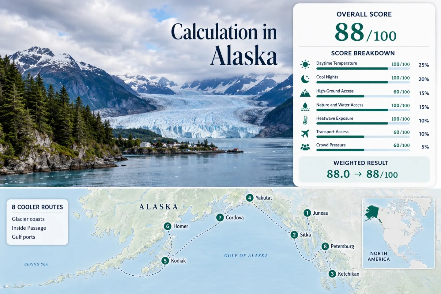
The score uses the same Juneau, Sitka, Ketchikan, Yakutat, Kodiak, Homer, Cordova and Petersburg set shown on the map.
The route median comes from NOAA 1991–2020 daily maximum normals, not a statewide temperature average.
Night-time relief is strong across the set, with Cordova coolest and Ketchikan mildest by the selected station normals.
Only four valid July–August station-days reached 30°C from 2016 through 2025; the factor uses the median route rate.
Homer has the lowest and Cordova the highest two-month normal for days with at least 0.01 inch of precipitation.
Most towns are isolated from Alaska’s highway network; Homer is the road-connected exception in this route set.
Inside Passage Towns, Gulf Ports and Glacier Coasts
The markers connect Southeast Alaska’s island towns with Gulf of Alaska bases where glaciers, temperate rainforest, marine wildlife and cool summer air shape the travel day.
Markers show selected cooler-route regions and approximate public planning centers, not guaranteed legal parking, trailheads, docks or exact viewpoints. Use each destination entry for its Google Maps search and verify local access before traveling.
Alaska Coastal Cooler Escape Suitability Score
This is a transparent editorial suitability index based on disclosed climate, landscape, access and pressure factors. It is not an official climate classification or a weather forecast.
Each route carries equal weight. Route count creates no bonus; the factor value is the median of the eight route values or rubric scores.
Glacier Towns, Island Ports and Wild Coastal Bases
The eight destinations use the same station set as the score. Temperature values are July–August 1991–2020 normals; wet-day values count normal days with at least 0.01 inch of precipitation across the two months.
Juneau and Mendenhall Glacier
Juneau’s direct airport station averages 17.5°C days and 9.8°C nights in July–August. The two-month normal includes 37.9 wet days, while Mendenhall Glacier sits roughly 12 miles from downtown within a developed recreation area.
Private shuttles, taxis and tours create the clearest land-based glacier access in the set, but high-volume cruise days can tighten transport and visitor-center capacity. Mount Roberts and the Juneau Icefield place major vertical relief immediately behind the coastal base.
Sitka and Baranof Island
Sitka’s Pacific-facing station records a 16.2°C normal daytime high and an 11.5°C normal low, with 38.3 wet days across July and August. The town is compact, while rainforest trails climb quickly toward Gavan Hill and Mount Verstovia.
The trade-off is not summer heat but frequent wet weather and exposed marine conditions. The ferry terminal is outside the central core, so a car-light stay still needs a planned transfer on arrival or departure day.
Ketchikan and Revillagigedo Island
At 18.1°C by day and 11.8°C at night, Ketchikan is the mildest rather than the coldest route in the set. Its station normal still remains far below typical hot-summer city conditions, and the two-month wet-day total is 32.8.
The airport sits across Tongass Narrows and requires a short ferry transfer. Borough buses help along the road corridor, while Deer Mountain provides meaningful elevation close to town. Watch for: Cruise-ship arrival peaks can transform a compact downtown even when trail and forest conditions remain quiet.
Yakutat and Hubbard Glacier Coast
Yakutat combines a 16.5°C normal high, a 9.1°C normal low and 38.1 wet days with one of the most dramatic mountain-to-ocean settings in Alaska. The Saint Elias relief is visually immediate, but routine high-ground access is far less direct than the skyline suggests.
No 30°C day appeared in 613 valid July–August observations from 2016–2025. The low heat exposure is clear, yet weather can interrupt flightseeing, charters and onward connections.
Kodiak and Kodiak Island
Kodiak’s July–August station normals average 16.8°C by day and 10.2°C at night. Its 29.4 wet-day total is lower than Southeast Alaska’s wettest bases, and only one of 620 valid station-days reached 30°C during the ten-summer threshold period.
The airport and ferry terminal support regional access, but a vehicle is useful for the island’s road-accessible bays, rivers and trailheads. More remote bear-viewing areas require licensed aircraft or boat operations, making weather and operator capacity part of the itinerary.
Homer and Kachemak Bay
Homer is the only route base in the set connected directly to Alaska’s main road system. The airport station averages 17.1°C days and 9.2°C nights, while 26.4 wet days make it the comparatively drier coastal option among the eight.
The town, bluff and Homer Spit form the service base; the AMHS terminal lies about six miles from town. Kachemak Bay State Park and the opposite-shore trail system shift the day onto water taxis, where wind and sea state can control timing.
Cordova and the Copper River Delta
Cordova has the coolest normal nights in the route set at 8.3°C, paired with a 16.5°C normal daytime high. It also has the highest two-month wet-day total at 38.9, so its comfort comes with a strong rain and cloud trade-off.
Scheduled air and Prince William Sound ferry links reach a town with no external road connection. A local vehicle expands access toward the Copper River Delta and Chugach foothills, but it does not solve marine or aviation disruption.
Petersburg and LeConte Glacier
Petersburg’s local station averages 16.4°C by day and 10.4°C at night, with 33.8 wet days across July and August. Its daily threshold record showed 0 days at or above 30°C in 557 valid observations, still an 89.8% coverage rate.
The compact town has scheduled air and ferry access; the AMHS terminal is about two miles from the center. LeConte Glacier access is normally by boat or flight, while island roads and trails provide lower-elevation forest alternatives when marine conditions close the glacier window.
Heat, Rain and Access Across the Eight Coastal Bases
The table preserves the complete map and score route set. Temperature describes historical July–August normals; the access column identifies the transport step most likely to change the trip.
| Route | Normal High / Low | Wet Days | Glacier or Wild Access | Main Arrival | Planning Trade-Off |
|---|---|---|---|---|---|
| Juneau and Mendenhall Glacier | 17.5°C / 9.8°C | 37.9 | Road, shuttle or tour | Air + ferry | Cruise-day transport pressure |
| Sitka and Baranof Island | 16.2°C / 11.5°C | 38.3 | Town-edge rainforest trails | Air + ferry | Frequent rain and exposed coast |
| Ketchikan and Revillagigedo Island | 18.1°C / 11.8°C | 32.8 | Road corridor + steep trail | Air-ferry transfer + AMHS | Concentrated cruise peaks |
| Yakutat and Hubbard Glacier Coast | 16.5°C / 9.1°C | 38.1 | Boat or aircraft | Scheduled air | Small inventory and weather risk |
| Kodiak and Kodiak Island | 16.8°C / 10.2°C | 29.4 | Road corridor; remote sectors by air or boat | Air + ferry | Vehicle useful; wildlife logistics |
| Homer and Kachemak Bay | 17.1°C / 9.2°C | 26.4 | Water taxi beyond the Spit | Road + air + ferry | Marine timing after easy land arrival |
| Cordova and the Copper River Delta | 16.5°C / 8.3°C | 38.9 | Local road network + boat or air | Air + ferry | No external road; frequent wet days |
| Petersburg and LeConte Glacier | 16.4°C / 10.4°C | 33.8 | Boat or flightseeing | Air + ferry | Limited sailings and excursion capacity |
The Marine Highway Does Not Form One Continuous Coastal Loop
Ferry access is real, but Alaska’s coast should be treated as transport clusters rather than a hop-on circuit. Published running times show why distance and schedules can outweigh the apparent closeness of towns on a map.
Inside Passage Cluster
Ketchikan, Petersburg, Juneau and Sitka share the Southeast system, yet sample running times include roughly 20 hours from Ketchikan to Juneau, eight hours from Petersburg to Juneau and nine and a half hours from Juneau to Sitka. A missed sailing can consume more than a sightseeing day.
Gulf of Alaska Cluster
Homer–Kodiak is listed at about nine hours and Whittier–Cordova at about six hours forty-five minutes. Yakutat does not function as a dependable bridge between Southeast and Southcentral itineraries; scheduled air is the practical connector when through-ferry patterns are absent.
Homer Is the Road Exception
Homer can be reached overland from Anchorage and paired with a rental-car itinerary. Juneau, Sitka, Ketchikan, Yakutat, Cordova and Petersburg lack a road connection to the continental highway system, while Kodiak’s road network stays on the island.
Glacier Days Use Road, Boat and Aircraft Access Models
Mendenhall’s Developed Approach
Juneau offers the least weather-sensitive land approach: the glacier recreation area is reached by road, shuttle, taxi or tour. The advantage is predictable ground access; the trade-off is capacity pressure and a visible retreating-glacier landscape rather than a tidewater-glacier boat encounter.
LeConte and Hubbard by Water
Petersburg’s LeConte excursions and Yakutat’s Hubbard Glacier coast move the decisive part of the day onto a vessel. Sea state, fog, ice conditions, operator limits and dock timing can cancel the primary objective even when the town itself remains comfortable.
Remote Ice by Aircraft
Yakutat, Cordova, Kodiak and Juneau support flightseeing or remote-access possibilities, but aircraft are the most weather-sensitive model. A glacier flight should not sit immediately before a nonrefundable ferry or long-haul departure.
Rain Frequency, Not Heat, Separates the Coastal Bases
All eight routes score strongly for temperature. The sharper distinction is how many July–August days normally record measurable precipitation and how much schedule flexibility the route allows.
Homer and Kodiak Reduce the Wet-Day Burden
Homer’s 26.4 and Kodiak’s 29.4 normal wet days are the lowest in the set. They remain maritime routes, but a longer run of usable outdoor hours is more plausible than in the wettest Gulf and Southeast bases.
Cordova, Sitka, Yakutat and Juneau Need Flexible Days
These four bases sit near 38 wet days across July and August. A wet-day count means at least 0.01 inch was recorded, not continuous rain, yet rigid boat, aircraft and trail plans carry more failure points.
Ketchikan and Petersburg Sit Between
Ketchikan’s 32.8 and Petersburg’s 33.8 wet days form a middle band. Waterproof layers remain essential, but both towns provide forest, harbor and short-road alternatives when higher terrain or marine excursions lose visibility.
Long Daylight, Wildlife Distance and Marine Delays Shape the Day
Late Light Extends Activity and Delays Sleep
Coastal Alaska retains long evening light through peak summer. Early starts for charters can follow bright late nights, so blackout curtains or an eye mask matter more than they do on a conventional city break.
Wildlife Distance Is a Route Decision
Kodiak, Yakutat and Cordova place travelers close to bear, salmon and shorebird habitat. Food control, group behavior, local closures and operator instructions are not side notes; they determine which trail, river or viewing area remains appropriate.
A Buffer Day Protects Ferry and Flight Connections
Fog, wind and mechanical changes can affect ferries, small aircraft and marine tours independently. Keep one uncommitted day inside the same town or transport cluster rather than relying on a same-day excursion-to-departure sequence.