Canada Coolcation Routes: Mountain Parks, Lake Towns and Fresh Summer Air
Canada’s strongest less-hot summer routes are not spread evenly across the country. The clearest pattern appears where high-elevation town bases, glacial lakes, forested park corridors and rapid access to cooler ground overlap. Banff, Jasper, Canmore, Waterton, Revelstoke, Nelson and Mont-Tremblant create a deliberately mixed portfolio: the Rockies deliver the strongest night cooling, interior British Columbia adds lake-town character with hotter valley afternoons, and the Laurentians provide a more accessible eastern option with cooler forest-and-water days than major lowland cities.
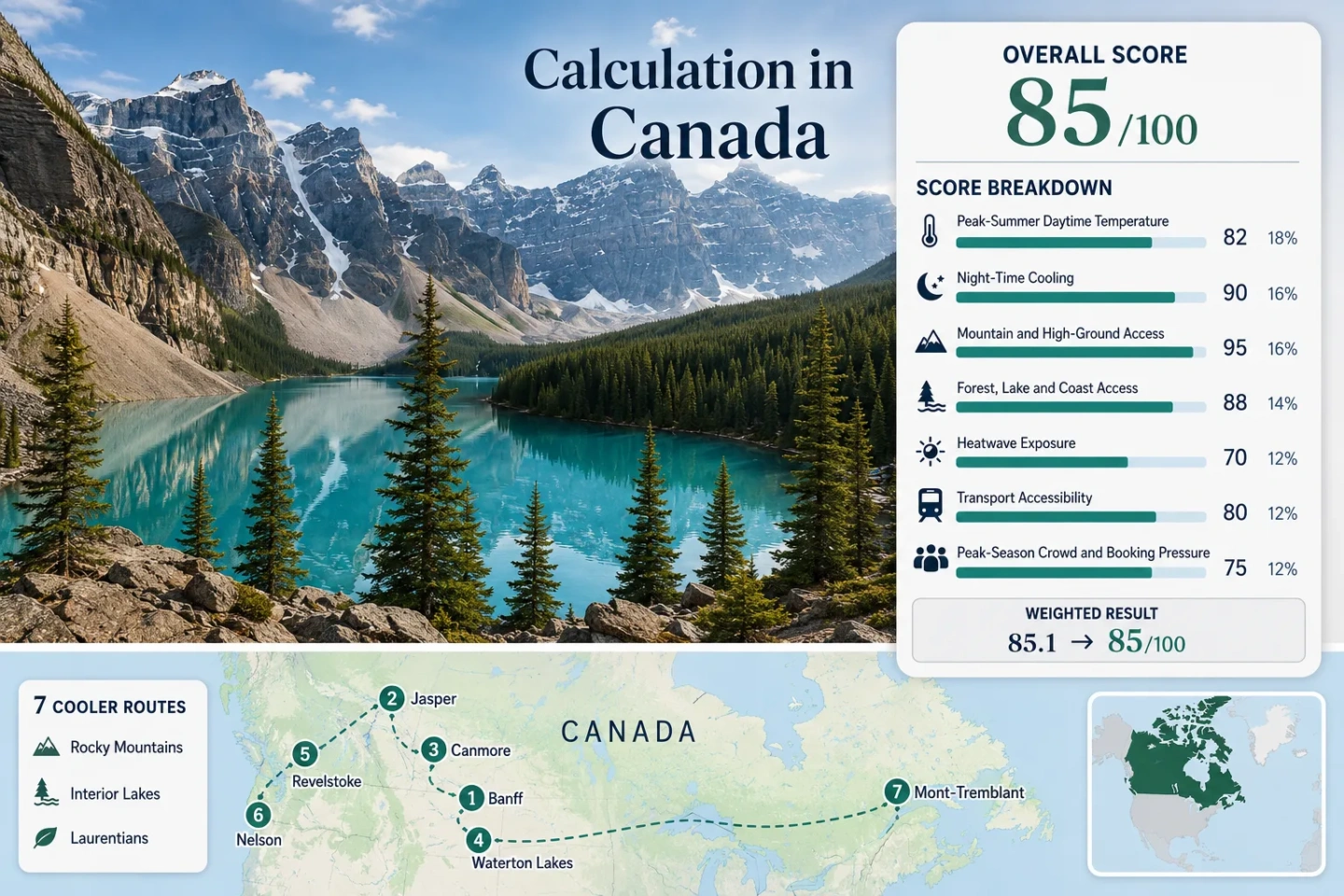
Four Rocky Mountain bases, two British Columbia lake-and-mountain towns and one Laurentian park route.
Banff, Jasper and Kananaskis combine elevated lodging bases with fast access to lakes, passes and shaded valleys.
The seasonal parkway rises roughly 1,600 metres from the valley toward subalpine terrain over about 25–26 kilometres.
Banff has regional and park shuttles; Jasper sits on VIA Rail’s transcontinental route, though many trailheads still need local transport.
Moraine Lake requires commercial or shuttle access, while Waterton and several Jasper trailheads can reach parking limits.
Fresh mornings do not remove heatwave, wildfire-smoke or afternoon thunderstorm risk, especially in interior valleys.
Rocky Mountain Parks, Interior Lakes and the Laurentians
The marker set follows the same seven routes used in the score and comparison sections, from Alberta’s high park towns to British Columbia’s Columbia–Kootenay corridor and Quebec’s Laurentian lake country.
This marker map is built for planning orientation. Marker positions use approximate public location centres where exact viewpoints, trailheads, legal parking areas or pull-offs are not specified. Markers show selected cooler-route regions, not guaranteed legal parking or exact navigation points. Use each route card for Google Maps links and current access notes.
Canada Mountain-and-Lake Cooler Escape Suitability Score
This transparent editorial suitability index is based on disclosed climate, landscape, access and pressure factors for the seven routes shown here. It is not an official climate classification or a weather forecast.
Weighted total: 81×0.25 + 89×0.20 + 100×0.15 + 100×0.15 + 87×0.10 + 80×0.10 + 40×0.05 = 86.8 → 87/100
Method: Route count does not add bonus points. Each route has equal weight inside a factor, route-level values are combined using the median, and the seven fixed factor weights are then applied.
High Park Towns, Glacial Lakes and Forested Summer Bases
The route set deliberately mixes strong night-cooling bases with lake towns that need a vertical escape during hotter afternoons. The temperature figures are the rounded July–August route values used in the score, not forecasts.
Banff–Lake Louise
Elevation does most of the work. Banff sits near 1,383 m and Lake Louise village is higher still, while the route’s representative July–August station value is about 22.1°C by day and 7.0°C at night. That combination gives cooler sleeping conditions than most Canadian city breaks and keeps high lakes within a short travel radius.
Moraine Lake Road is not open to general private vehicles in the main visitor season. Parks Canada shuttles require reservations, and 2026 inventory is released partly on the April launch date and partly two days before departure.
Jasper
Jasper’s town base is roughly 1,060 m, with a representative July–August value near 22.9°C for daytime maxima and 7.5°C for night minima. VIA Rail serves the town directly, while Pyramid Lake, Patricia Lake, Maligne Lake and the Icefields Parkway distribute visitors across several distinct cooling zones.
2026 access differs from older itineraries. Maligne Canyon and Cavell Road remain closed for the 2026 season because of post-wildfire rehabilitation, and some campground capacity remains unavailable. Parks Canada’s current open/closed map should shape the route before accommodation is booked.
Canmore–Kananaskis
Canmore provides a service-rich base at about 1,309 m, while Kananaskis adds higher trailheads, Spray Lakes, forest corridors and Peter Lougheed Provincial Park. The representative high-country station value used here is about 21.3°C by day and 5.9°C at night for July–August.
A Kananaskis Conservation Pass applies to vehicles parked in the designated area. Canmore itself is comparatively car-light; many lake and trailhead days are not.
Waterton Lakes
Wind changes the comfort profile. Waterton’s climate is described by Parks Canada as mild, moist, windy and quick to change. The townsite is around 1,280 m, and the representative July–August route values used here are 24.2°C by day and 8.5°C at night.
Upper Waterton Lake brings a strong water-and-mountain setting, but exposed shorelines can feel much cooler than sheltered streets. More than 600 village parking spaces provide a walkable base after arrival, yet popular day-use lots may fill by about 11 a.m. on summer weekends.
Revelstoke–Mount Revelstoke
Revelstoke’s valley base is warmer than the Alberta park towns: the route value used here is about 26.8°C by day and 11.9°C at night in July–August. The cooling advantage comes from vertical range rather than a uniformly cool town climate.
The Meadows in the Sky Parkway runs about 25–26 km and gains roughly 1,600 m toward subalpine terrain. Snowmelt controls full opening; Parks Canada notes that the latest opening can fall in the first week of August, although access is usually earlier.
Nelson–Kootenay Lake
Nelson is the warmest lodging base in this set, with a route value near 28.1°C by day and 12.4°C at night for July–August. Kootenay Lake, forest shade and rapid access toward the Selkirks make the area flexible, but they do not erase hot interior afternoons.
The Kootenay Lake ferry crosses between Balfour and Kootenay Bay in about 35 minutes. The main vessel carries 70 vehicles and 144 passengers; extra summer sailings operate through the high-demand season, but queues can still alter a lake-loop day.
Mont-Tremblant–Laurentians
Mont-Tremblant adds an eastern, forest-and-lake route to a portfolio otherwise dominated by western mountains. The representative July–August station value is about 24.7°C by day and 12.0°C at night, with higher humidity than the Alberta Rockies.
Parc national du Mont-Tremblant is open year-round, and partner transport services reach the La Diable and Pimbina–Saint-Donat sectors. The route is more accessible from a major metropolitan area than most western park bases, but shuttle frequency and final-mile movement still need advance checking.
Four Access Rules That Reshape a 2026 Canada Coolcation
Temperature alone does not determine whether a mountain-and-lake route works. Four current access conditions can change the order of the itinerary.
Moraine Lake Is a Transport Reservation, Not a Driving Stop
General private-vehicle access is not the default summer option. Parks Canada shuttles require reservations, with 2026 seats divided between the April release and a rolling release two days before travel. A Banff stay without a confirmed lake-transfer plan can lose its main lake day.
Jasper’s Open Map Matters More Than an Older Checklist
Maligne Canyon and Cavell Road remain closed for the 2026 season, and parts of the campground system are still affected by wildfire recovery. Pyramid, Patricia, Maligne Lake and the Icefields Parkway remain useful, but route substitution is part of the planning process.
Kananaskis Depends on the Exact Road Approach
The Highway 742 Canmore Hill closure breaks the usual assumption that Canmore and the Spray corridor connect in a simple loop. Highway 40 remains the more reliable access spine for many 2026 plans, subject to live Alberta Parks and 511 updates.
Snowmelt Controls the Highest Revelstoke Day
The parkway’s value comes from its large elevation gain, but full summit access is seasonal. July can still involve partial opening or snow-affected trails; August usually offers the clearest combination of road access, subalpine hiking and wildflower timing.
Seven Routes Compared by Heat, Altitude and Access Friction
All seven map and score routes appear here. Day/night figures are the rounded July–August values used in the index; access notes reflect the route’s practical cooling terrain rather than arrival at the town alone.
| Route | Base and altitude logic | July–August day / night | Car-light potential | Main capacity issue | Weather trade-off |
|---|---|---|---|---|---|
| Banff–Lake Louise | High lodging bases with immediate access to passes and glacial lakes | 22.1°C / 7.0°C | Strong | Moraine and Lake Louise shuttle/parking pressure | Cold mornings, storms and smoke can interrupt lake days |
| Jasper | High town base with multiple lake and parkway corridors | 22.9°C / 7.5°C | Strong for arrival; mixed for trailheads | Recovery-related closures and reduced capacity | Large daily range, smoke and fast mountain weather |
| Canmore–Kananaskis | High town plus very high trailheads and reservoir corridors | 21.3°C / 5.9°C | Moderate | Trailhead parking and current road disruption | Very cool nights; exposed passes change quickly |
| Waterton Lakes | High lake town beneath steep southern Rockies | 24.2°C / 8.5°C | Limited | Weekend day-use parking | Persistent wind and abrupt shifts |
| Revelstoke–Mount Revelstoke | Warm valley base with a roughly 1,600 m vertical escape | 26.8°C / 11.9°C | Limited for high ground | Seasonal parkway and summit parking | Interior heat and wildfire smoke |
| Nelson–Kootenay Lake | Warm lake town with Selkirk high-ground access | 28.1°C / 12.4°C | Moderate in town; limited for loops | Summer ferry queues | Hot afternoons and smoke; lake breezes vary |
| Mont-Tremblant–Laurentians | Lower upland base with broad forest-and-lake access | 24.7°C / 12.0°C | Moderate | Reservations and limited shuttle frequency | Humidity, showers and less dramatic night cooling |
Why Revelstoke and Nelson Need a Two-Level Day
Valley Hours: Early Morning and Evening
Revelstoke and Nelson are not consistently cool town bases. Their route values sit near 26.8°C and 28.1°C for July–August daytime maxima, and both can exceed 30°C during interior heat events. Waterfront walks, markets and town streets fit more comfortably before late morning or after the sun drops behind the ranges.
High-Ground Hours: Midday and Afternoon
Mount Revelstoke’s parkway, Selkirk trailheads and higher forest roads create the actual coolcation mechanism. The route works when the itinerary changes elevation during the day; a lake-facing hotel alone does not reproduce the temperature of subalpine terrain.
Smoke contingency: Interior British Columbia needs a second route plan that does not depend on distant views or strenuous high-elevation activity. Check provincial wildfire, air-quality and road information on the morning of travel.
Lake Air Does Not Mean Warm Water or Stable Wind
Glacial Lakes Stay Cold
Lake Louise, Moraine Lake and many Jasper waters can remain dangerously cold even on warm afternoons. Shoreline air may feel refreshing, but swimming assumptions should not be transferred from lower, warmer recreational lakes.
Waterton Can Feel Cooler Through Exposure
Waterton’s long lake corridor funnels wind. The same exposed shore that reduces heat can make a calm-looking day feel much colder, complicate paddling and increase the need for a wind layer.
Kootenay Lake Runs on Ferry Rhythm
The Balfour–Kootenay Bay crossing takes about 35 minutes, but the schedule and vehicle queue determine the real duration. Early or later sailings reduce the risk that a lake loop becomes a stationary midday wait.
When the Mountain Roads, Lakes and Nights Align
Late June
Useful for: Long daylight, cooler town temperatures and lighter pressure before the main school-holiday peak.
Trade-off: High trails and Mount Revelstoke summit access may still be snow-limited; cold water is not a swimming signal.
July
Useful for: The widest mix of park roads, lake access, transport services and long hiking days.
Trade-off: Banff, Jasper, Waterton and Mont-Tremblant face stronger booking pressure; interior B.C. heat and smoke risk rise.
August
Useful for: More reliable high-elevation access at Mount Revelstoke and mature summer schedules across the route set.
Trade-off: Warm interior valleys, ferry queues and wildfire smoke can be more consequential than at the start of summer.
Early September
Useful for: Cooler nights and easing family-travel pressure while many park services still operate.
Trade-off: Shorter daylight, earlier frost at high bases and the first seasonal service reductions require tighter daily timing.
Forecast discipline: Recheck park bulletins, road status, wildfire smoke, air quality, shuttle inventory and local forecasts within 24–48 hours of each major route day. A national-scale itinerary can cross very different weather regimes within a single week.