Greenland for Cold-Summer Travel: Fjords, Ice Views and Arctic Escapes
Greenland offers a form of summer relief that is colder, sharper and more logistically demanding than a mild coastal break. July and August route normals across the selected bases produce a median daytime maximum of about 10.9°C, while the median night falls to about 4.2°C. Fjord water, sea ice, glaciers and Arctic latitude keep most coastal routes cool, but the inland air at Kangerlussuaq can produce noticeably warmer afternoons. Flights, helicopters and boats replace inter-town roads, so the strongest itinerary pairs cold-air scenery with generous weather and connection buffers.
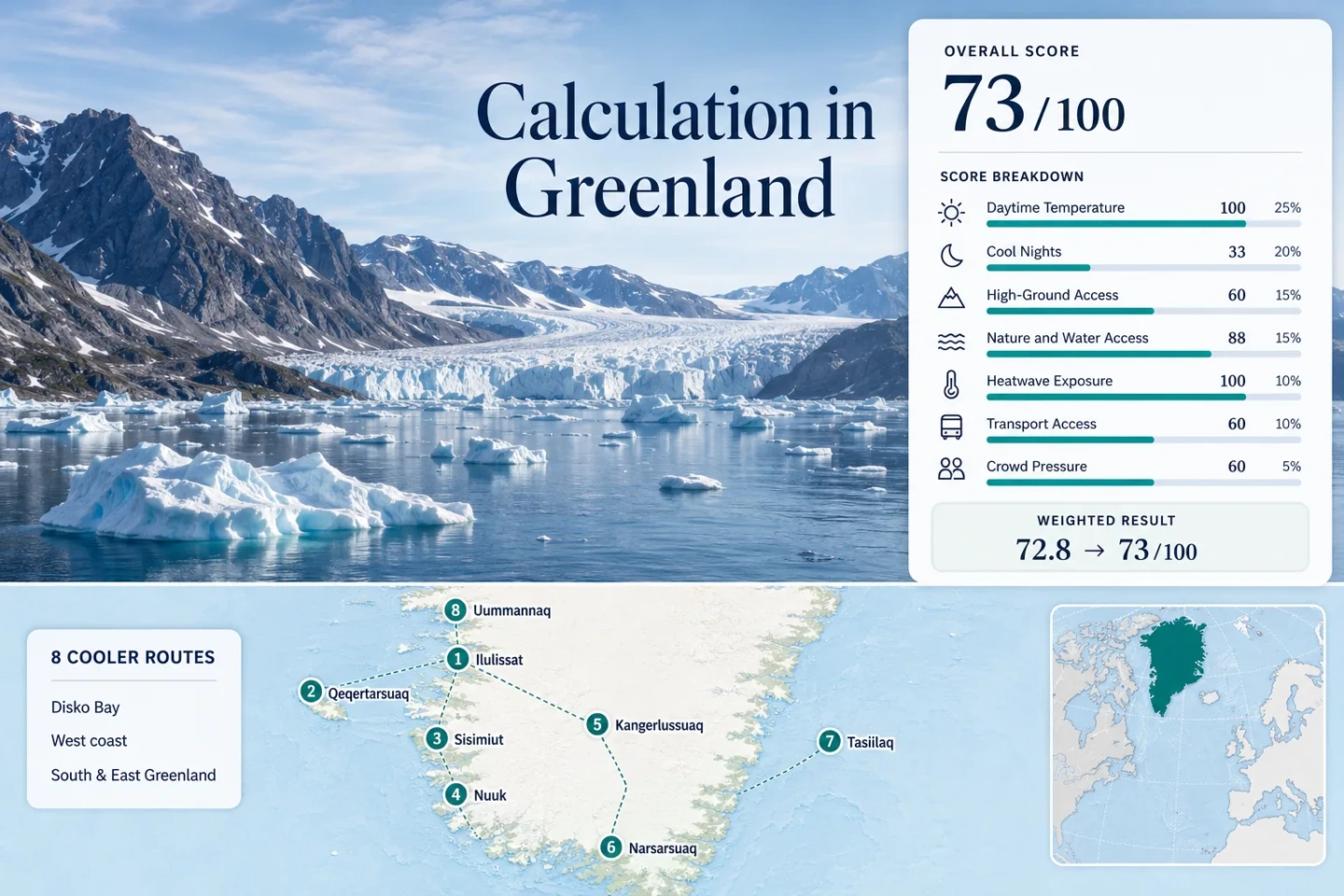
Disko Bay, the west coast, South Greenland and East Greenland are represented by the same routes used in the map and score.
The route median uses DMI mean daily maximum temperatures, not a whole-country average.
Cold evenings are a planning factor, especially after boat trips, exposed walks and late daylight.
The UNESCO-listed icefjord is approximately 6 km wide and 55 km long, giving Ilulissat the clearest large-scale ice focus.
Domestic flights, helicopters, local boats and the west-coast ferry shape the itinerary more than driving distance.
Kangerlussuaq has the highest July–August daytime normal in this route set because its inland climate is more continental.
Fjord Towns, Icefronts and Arctic Route Bases
The markers identify planning centers for eight cold-summer routes. They do not identify exact viewpoints, legal landing places, trailheads or boat approaches. Greenland travel depends on current flight, helicopter, ferry and excursion conditions, so route cards should be checked against live operator information before departure.
Planning marker map only. Marker positions use approximate public location centers where exact harbors, excursion landings, trails or viewpoints are not specified.
Greenland Fjord-and-Ice Suitability Score
This transparent editorial suitability index uses disclosed climate, landscape, access and pressure factors for the eight selected routes. It is not an official climate classification, safety rating or weather forecast.
Weighted total: 100×0.25 + 33×0.20 + 60×0.15 + 88×0.15 + 100×0.10 + 60×0.10 + 60×0.05 = 72.8 → 73/100
Method: Route count does not add points. Route-level values are combined with the median before the fixed factor weights are applied. The lower night score reflects that very cold nights fall outside the method’s 10–16°C sleep-comfort band.
Icefjords, Coastal Towns and Inland Arctic Air
Each route uses the same July–August climate evidence as the score, but the travel experience changes sharply between iceberg-heavy bays, urban fjords, an inland airport settlement and remote east- or northwest-coast connections.
Ilulissat Icefjord
Ilulissat combines a walkable town base with direct access to a UNESCO-listed icefjord approximately 6 km wide and 55 km long. The mapped station’s July–August normals average 10.6°C by day and 4.0°C at night. Boardwalk and marked-route access give land-based ice views, while local boats add a water-level perspective.
Qeqertarsuaq
Qeqertarsuaq places an island town between Disko Bay, dark basalt terrain, mountain lakes and the high ground leading toward Lyngmark. Aasiaat provides the nearest long-period representative climate series, with a July–August mean of 9.0°C by day and 4.2°C at night. The island is colder and slower-paced than the inland route, but summer arrival normally requires an onward boat or helicopter connection.
Sisimiut
Sisimiut is a practical west-coast base where mountain ridges begin close to town and the Sarfaq Ittuk coastal ferry can be combined with domestic air travel. The station normal is 11.2°C by day and 4.4°C at night for July–August. It works well for travelers who want Arctic hiking and a functioning town without making every outing dependent on a long boat excursion.
Nuuk Fjord
Nuuk gives the route set its strongest service base: an international airport, domestic connections, urban buses, shops and a large year-round fjord-tour market. July–August normals average 10.1°C by day and 4.3°C at night. Mountains rise from the suburbs, and the fjord system begins within minutes of the city center.
Kangerlussuaq
Kangerlussuaq is the outlier in a coast-dominated set. Its inland location produces a July–August mean of 15.4°C by day and 4.2°C at night, creating a larger day-night swing and a higher chance of mild walking weather. It also has one of Greenland’s rare long road corridors, extending toward the ice-sheet margin through dry tundra and river country.
Narsarsuaq and Qooroq Ice Fjord
South Greenland’s greener valley landscape gives Narsarsuaq a different Arctic character. The July–August station averages are 14.9°C by day and 6.3°C at night, the mildest nights in the set. Qooroq adds iceberg-filled water and a calving-glacier excursion, while the arboretum and river valley provide unusual plant cover for Greenland.
Tasiilaq
Tasiilaq sits among steep mountains, glacier valleys and iceberg-filled East Greenland waters. July–August normals average 10.6°C by day and 3.7°C at night. There are no direct flights to town: travelers arrive through Kulusuk and continue by a roughly 15-minute helicopter transfer or a summer boat transfer commonly quoted at 30–45 minutes.
Uummannaq
Uummannaq is a compact island town below a 1,175 m mountain, surrounded by a fjord known for enormous icebergs and summer boat travel. The representative Qaarsut station gives July–August means of 11.4°C by day and 5.4°C at night. Arrival commonly requires an Ilulissat–Qaarsut flight chain followed by helicopter or boat, and there is no regular scheduled boat service directly to town.
Choosing Between Greenland’s Eight Cold-Summer Bases
The same low-temperature headline can conceal very different transport chains and route purposes. The table keeps every mapped and scored route visible while separating climate, access and the principal planning trade-off.
| Route | July–August Day / Night | Arrival Pattern | Cold-Summer Signature | Main Trade-Off |
|---|---|---|---|---|
| Ilulissat Icefjord | 10.6°C / 4.0°C | Airport plus local boats | Large icefjord and land-based viewpoints | High summer booking pressure |
| Qeqertarsuaq | 9.0°C / 4.2°C | Seasonal boat or helicopter connection | Disko Island coast, basalt and high ground | Slower island logistics |
| Sisimiut | 11.2°C / 4.4°C | Airport and coastal ferry | Town-edge mountains and west-coast access | Less concentrated glacier scenery |
| Nuuk Fjord | 10.1°C / 4.3°C | International and domestic air hub | Urban services beside a huge fjord system | Excursions still depend on boat weather |
| Kangerlussuaq | 15.4°C / 4.2°C | Airport plus local road corridor | Dry inland tundra and ice-sheet road | Warmer afternoons than coastal bases |
| Narsarsuaq and Qooroq Ice Fjord | 14.9°C / 6.3°C | Qaqortoq connection, helicopter and boats | Green valley, arboretum and iceberg fjord | 2026 gateway transition complicates access |
| Tasiilaq | 10.6°C / 3.7°C | Kulusuk flight plus helicopter or boat | East-coast peaks, glaciers and ice-filled water | Remote transfers and limited capacity |
| Uummannaq | 11.4°C / 5.4°C | Qaarsut flight plus helicopter or boat | Mountain island and enormous fjord icebergs | No regular scheduled boat service to town |
Disko Bay Ice Air Versus Kangerlussuaq’s Inland Warmth
Cold Water Controls the Coastal Routes
DMI describes Greenland’s coastal summer zone as strongly influenced by cold, partly ice-filled seas. Ilulissat, Qeqertarsuaq, Nuuk, Tasiilaq and Uummannaq therefore combine low air temperatures with wind, fog and cold surfaces nearby. A nominal 10–11°C can feel harsher on an open boat than the same temperature on a sheltered inland path.
Kangerlussuaq Has the Largest Day–Night Split
Kangerlussuaq reaches a 15.4°C daytime normal while its night normal remains near 4.2°C. That 11.2°C average day–night range is useful for dry daytime walking but still calls for insulated evening layers. It is the route to choose when a cold-summer trip should include some milder afternoon hours.
Flights, Helicopters and Boats Replace a Road Itinerary
Greenland’s towns are not linked by a conventional highway system. Nuuk, Ilulissat, Sisimiut and Kangerlussuaq are comparatively straightforward air bases, yet excursions beyond town still depend heavily on boats. Qeqertarsuaq adds an island transfer; Tasiilaq requires the Kulusuk connection; Uummannaq uses Qaarsut as the air gateway; and Narsarsuaq’s fixed-wing role changed when Qaqortoq Airport opened on April 16, 2026.
The west-coast Sarfaq Ittuk ferry adds continuity between ports, but July and August are peak months and advance booking is advised. A workable plan therefore separates critical transfers with overnight buffers rather than chaining a flight, helicopter and boat into one inflexible day. Distance on the map is less important than the number of weather-sensitive handoffs.
Midnight Light, Summer Fog and Remote-Capacity Limits
Long Daylight Does Not Mean Warm Nights
Ilulissat, Qeqertarsuaq, Sisimiut and Uummannaq have extremely long summer daylight, yet their night normals remain near 4–5°C. An eye mask or effective blackout curtains help sleep timing, while a warm layer remains necessary for late walks and harbor waits.
Fog and Wind Can Rewrite a Boat Day
Cold water and sea ice favor summer fog along exposed coasts. Boat excursions may change even when the temperature forecast looks stable. Keep one land-based day available in Ilulissat, Nuuk or Sisimiut and avoid placing the only ice excursion immediately before a critical flight.
East and Northwest Routes Need More Supply Margin
Tasiilaq receives major supply shipments only a limited number of times during the navigable season, while Uummannaq and Qeqertarsuaq have smaller transport and lodging inventories than Nuuk. Bring essential medication, specialized outdoor gear and enough schedule flexibility to absorb a missed connection.
Cold-Summer Comfort Depends on Schedule Space
Greenland’s strongest summer advantage is reliable relief from high heat, not predictable calm weather. Check DMI forecasts, Greenland Airports flight information, Air Greenland updates, ferry status and local boat operators close to departure. A route with one unused buffer day is usually more resilient than a longer itinerary built from tight same-day connections.