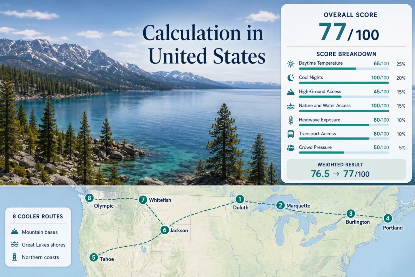
United States Cooler Escapes: Mountain States, Lake Towns and Northern Coasts
Summer heat varies sharply across the United States. The eight routes assessed here use Rocky Mountain elevation, Lake Superior’s cold-water influence, large northern lakes and Atlantic or Pacific marine air to create alternatives to hotter inland cities during July and August. Afternoon warmth remains possible, but several bases combine milder daytime normals with distinctly cooler nights.
Three high-elevation routes, two Great Lakes routes, two northern ocean-coast routes and one Lake Champlain base.
Median of the eight representative NOAA station normals rather than a national temperature average.
High mountain basins and northern shore stations provide the clearest overnight temperature relief.
Quillayute’s July–August normal daytime maximum averages about 20.1°C, with persistent Pacific marine influence.
Both lodging bases sit above 1,890 m, producing cool nights even when dry afternoons become warm.
Western wildfire smoke, mountain-road delays, full park lots and limited shuttle seats can alter an otherwise strong route.
Great Lakes, Rocky Mountain and Northern Shore Bases
The marker set spans Lake Superior, Lake Champlain, Casco Bay, Lake Tahoe, the central Rockies, Glacier Country and Washington’s outer Olympic coast. The large distances make these separate regional trips, not a practical single driving loop.
This marker map is built for planning orientation. Marker positions use approximate public location centers where exact viewpoints, trailheads, legal parking areas or pull-offs are not specified. Markers show selected cooler-route regions and planning centers, not guaranteed legal parking, trailheads or exact viewpoints.
United States Northern and High-Ground Suitability Score
This is a transparent editorial suitability index based on disclosed climate, landscape, access and pressure factors. It is not an official climate classification or a weather forecast. Every route carries equal weight, and route count does not add a scoring bonus.
The result describes the eight mapped routes rather than the full climatic range of the United States.
Method: July–August mean daily maximum for each mapped station, followed by the eight-route median and fixed linear normalization.
Raw: Median 26.0°C; the unrounded value is 26.01°C.
Route values: Duluth & Minnesota North Shore 24.9°C; Marquette & Pictured Rocks 23.9°C; Burlington & Lake Champlain 27.5°C; Portland & Casco Bay 26.2°C; South Lake Tahoe 26.7°C; Jackson & Grand Teton 25.9°C; Whitefish & Glacier Country 27.8°C; Olympic Coast & Quillayute 20.1°C. Median: 26.0°C.
Source mapping: Duluth USW00014913, direct urban station at 1,428 ft; Marquette USW00094850, representative station roughly 8–10 miles west and about 800 ft above the waterfront; Burlington USW00014742, direct metropolitan station roughly 3 miles east and about 230 ft above the lakefront; Portland USW00014764, direct metropolitan station roughly 3 miles west at similar elevation; South Lake Tahoe USW00093230, direct basin station at 6,314 ft; Jackson USC00484910, direct town station at 6,210 ft; Kalispell Glacier AP USC00244558, representative station roughly 11 miles south of Whitefish with less than 100 ft elevation difference; Quillayute State AP USW00094240, direct Quillayute-area station and representative outer-coast station several miles inland from La Push.
Period: 1991–2020 climate normals.
Sources: Duluth NOAA table; Marquette NOAA table; Burlington NOAA table; Portland NOAA table; South Lake Tahoe NOAA table; Jackson NOAA table; Kalispell NOAA table; Quillayute NOAA table.
Method: July–August mean daily minimum for the same station set, followed by the route median.
Raw: Median 11.3°C, within the scoring system’s 10–16°C full-credit band.
Route values: Duluth & Minnesota North Shore 13.2°C; Marquette & Pictured Rocks 12.1°C; Burlington & Lake Champlain 16.4°C; Portland & Casco Bay 15.8°C; South Lake Tahoe 5.4°C; Jackson & Grand Teton 4.8°C; Whitefish & Glacier Country 8.1°C; Olympic Coast & Quillayute 10.6°C. Median: 11.3°C.
Source mapping: Direct stations are used for Duluth, Burlington, Portland, South Lake Tahoe and Jackson. Marquette is represented by the higher inland NOAA station; Whitefish by nearby Kalispell Glacier AP; the outer Olympic coast by Quillayute State AP. Station codes, approximate relationships and elevation differences are disclosed in the daytime factor.
Period: 1991–2020 climate normals.
Sources: NOAA U.S. Climate Normals access and the eight linked station tables in the daytime factor.
Method: Fixed elevation-access rubric applied independently to each route, followed by the route median.
Raw: Median route score 45/100.
Route scores: Duluth & Minnesota North Shore 30 — low coastal ridges without 1,000 m terrain inside the normal route; Marquette & Pictured Rocks 30 — limited elevation range; Burlington & Lake Champlain 60 — meaningful Green Mountain access within roughly an hour; Portland & Casco Bay 0 — no significant high-ground access within an hour; South Lake Tahoe 100 — lodging base above 1,900 m; Jackson & Grand Teton 100 — lodging base near 1,890 m with immediate higher terrain; Whitefish & Glacier Country 100 — base near 920 m and regular access to terrain above 1,500 m; Olympic Coast & Quillayute 30 — coastal base with high Olympic terrain requiring a substantial detour. Median: 45/100.
Route rationale: Scores measure usable elevation access, not mountain scenery or peak height.
Period: Access conditions reviewed July 15, 2026.
Sources: Minnesota DNR North Shore information; Pictured Rocks access; Green Mountain National Forest recreation; Lake Tahoe Basin recreation; Grand Teton roads; Going-to-the-Sun Road; Olympic road conditions.
Method: Fixed physical-access rubric measuring whether at least two major forest, lake, river or ocean systems can be reached within about 30 minutes.
Raw: Median route score 100/100.
Route scores: Duluth & Minnesota North Shore 100 — Lake Superior and boreal forest; Marquette & Pictured Rocks 100 — Lake Superior and extensive forest; Burlington & Lake Champlain 100 — Lake Champlain and Green Mountain forest approaches; Portland & Casco Bay 100 — Atlantic water and forested bay islands; South Lake Tahoe 100 — Lake Tahoe and national-forest land; Jackson & Grand Teton 100 — forest, Snake River and mountain lakes; Whitefish & Glacier Country 100 — Whitefish Lake and extensive forest; Olympic Coast & Quillayute 100 — Pacific coast and temperate rainforest. Median: 100/100.
Route rationale: The score measures practical proximity to cooling landscapes rather than scenic quality.
Period: Access reviewed July 15, 2026.
Sources: Minnesota DNR Gitchi-Gami trail; Pictured Rocks visitor information; Green Mountain National Forest; Casco Bay island service; Lake Tahoe recreation opportunities; Grand Teton National Park; Glacier visitor information; Olympic National Park.
Method: Official threshold-frequency fallback using NOAA’s published 1991–2020 mean number of July and August days reaching at least 90°F. The published threshold is 32.2°C rather than the scoring system’s preferred 30°C threshold, so this factor is treated as a warmer-threshold proxy and comparability is reduced to class C.
Raw: Median published threshold frequency 4.0% of July–August calendar days.
Route values: Duluth & Minnesota North Shore 2.1%; Marquette & Pictured Rocks 2.7%; Burlington & Lake Champlain 8.4%; Portland & Casco Bay 5.2%; South Lake Tahoe 1.6%; Jackson & Grand Teton 7.1%; Whitefish & Glacier Country 19.8%; Olympic Coast & Quillayute 1.5%. Median: 4.0%.
Source mapping: The same direct and representative NOAA stations used for the daytime and night factors are used here. Values are published climatological frequencies, not an incomplete daily-series count.
Period: 1991–2020 official climate-normal threshold frequencies.
Sources: NOAA climate-normal product description and the eight station tables linked in the daytime factor.
Method: Fixed transport rubric based on intercity arrival, local public transport and whether a private vehicle remains necessary for the principal cooling landscape.
Raw: Median route score 80/100.
Route scores: Duluth & Minnesota North Shore 80 — direct city transit, with a car useful along Highway 61; Marquette & Pictured Rocks 60 — regional access plus limited local and hiking shuttles; Burlington & Lake Champlain 100 — daily Amtrak, local buses and a walkable waterfront; Portland & Casco Bay 100 — air, rail, local buses and public ferries; South Lake Tahoe 80 — South Shore buses and seasonal attraction shuttles, with network gaps around the basin; Jackson & Grand Teton 80 — airport and START service, but park movement remains partly vehicle-dependent; Whitefish & Glacier Country 80 — direct Amtrak plus seasonal park connections; Olympic Coast & Quillayute 40 — multiple regional connections and limited service across a dispersed peninsula. Median: 80/100.
Route rationale: A rail station in town does not automatically produce full credit when the main park or coast remains difficult without a car.
Period: Timetables and service information reviewed July 15, 2026.
Sources: Duluth Transit schedules; Pictured Rocks shuttle information; Ethan Allen Express; Green Mountain Transit schedules; Greater Portland transit; Casco Bay Lines; South Shore service information; START maps and schedules; Whitefish Amtrak station; Glacier transport information; Clallam Transit routes.
Method: Fixed categorical rubric using official reservation, parking, shuttle and visitor-capacity evidence where comparable lodging occupancy was unavailable.
Raw: Median route score 50/100.
Route scores: Duluth & Minnesota North Shore 80 — weekend pressure without widespread mandatory booking; Marquette & Pictured Rocks 60 — all park camping reserved in advance and popular shoreline sites concentrated along one corridor; Burlington & Lake Champlain 80 — event and weekend pressure but limited park-capacity restrictions; Portland & Casco Bay 60 — summer ferry and island demand; South Lake Tahoe 40 — recurring beach, parking and road pressure; Jackson & Grand Teton 40 — full popular lots, entrance queues and 2026 construction delays; Whitefish & Glacier Country 20 — limited Logan Pass capacity, ticketed 2026 shuttle and three-hour parking controls; Olympic Coast & Quillayute 40 — popular park lots can fill and produce one- to two-hour waits. Median: 50/100.
Route rationale: The values measure planning friction rather than total annual visitor numbers.
Period: Current 2026 operating rules and capacity notices, reviewed July 15, 2026.
Sources: Pictured Rocks camping reservations; Grand Teton parking status; Grand Teton 2026 construction; Logan Pass 2026 access rules; Glacier 2026 shuttle tickets; Olympic summer capacity notice; Olympic current conditions.
Mountain Basins, Lake Towns and Northern Coastal Routes
The station figures are historical July–August normals. Local shorelines, exposed overlooks and mountain trailheads can differ sharply from the representative station, especially around Lake Superior and complex western terrain.
Duluth & Minnesota North Shore
Lake Superior delays summer warming and can create a marked temperature break between the shoreline and inland Minnesota. Duluth works as the service-rich base, while Highway 61 extends northeast through forest, river mouths, state parks and exposed lake viewpoints.
Marquette & Pictured Rocks
The route pairs Marquette’s lakefront services with the sandstone cliffs, beaches and forested Lakeshore Trail near Munising. The representative NOAA station is higher and farther inland than the waterfront, so its 23.9°C daytime and 12.1°C night normals should be treated as a regional comparison rather than a beach-level promise.
The Lakeshore Trail runs for about 42.4 miles between Munising and Grand Marais. Local hiking transport exists, but ordinary sightseeing remains much easier with a car.
Burlington & Lake Champlain
The strongest car-light lake-town option combines a downtown Amtrak terminus, Green Mountain Transit buses, a walkable waterfront and easy bicycle access. Lake Champlain moderates immediate shore conditions, while higher Green Mountain trailheads provide a backup when Burlington itself becomes warm.
Its 8.4% published ≥90°F frequency proxy is materially higher than the Great Lakes and Pacific-coast routes. Burlington is therefore more useful as a flexible lake-and-mountain base than as a low-temperature guarantee.
Portland & Casco Bay
Portland’s July–August normal maximum averages about 26.2°C and the normal minimum about 15.8°C. The city is warmer and more humid than the outer Olympic coast, but its combination of airport access, intercity rail, local buses and public island ferries creates a notably practical northern-coast stay.
South Lake Tahoe
Tahoe’s main advantage is not consistently cold afternoons. It is the combination of a 1,900 m lodging base, a large alpine lake, surrounding forest and strong overnight temperature release. Dry daytime sun can still feel intense, especially on exposed beaches and granite trails.
South Shore Route 50 supports movement through the urban corridor. The 2026 Emerald Bay shuttle adds daily seasonal access from mid-June through Labor Day, although the full basin remains easier to navigate with a car.
Jackson & Grand Teton
Jackson sits near 1,890 m, placing cool nights inside the lodging base rather than at the end of a mountain excursion. The July–August normal minimum is about 4.8°C, while the normal daytime maximum reaches about 25.9°C. Layers remain useful even after warm trail afternoons.
Grand Teton does not require timed entry in 2026, but popular parking areas fill and construction affects several roads and sites. A town stay can be partly car-light; broad park access still depends on a vehicle, cycling or limited private transport.
Whitefish & Glacier Country
Whitefish offers direct Empire Builder rail access, a lake beside town and high terrain in Glacier National Park. The nearby Kalispell station shows an 8.1°C July–August normal minimum, but also the warmest daytime normal and highest published ≥90°F frequency in the route set: 27.8°C and 19.8%.
For 2026, no vehicle reservation is required for Glacier, but the Logan Pass shuttle requires a dated $1 ticket from July 1 through September 7. Logan Pass parking uses a three-hour limit, and shuttle seats remain finite.
Olympic Coast & Quillayute
The outer Olympic Peninsula has the clearest low-daytime-temperature signal in the portfolio. Pacific air, fog and low cloud suppress many summer afternoons, while the Quillayute station remains close enough to represent the broader La Push–Forks planning zone.
Clallam Transit links Forks with La Push on Route 15, and most ordinary routes remain zero-fare in 2026. The wider park is highly dispersed, however, so a no-car itinerary must be built around specific bus corridors rather than assumed for the entire peninsula.
Lake Superior’s Cold-Water Lag Changes the Daily Route
Duluth and Marquette do not rely on elevation. Their useful temperature difference comes from remaining close to Lake Superior and avoiding unnecessary inland drift during the warmest hours.
Duluth’s Shore-to-Hill Gradient
The NOAA station sits at 1,428 ft above the waterfront, while many visitor areas lie much closer to lake level. A lake breeze can keep Canal Park and exposed shore stops noticeably different from neighborhoods higher and farther inland. Highway 61 preserves the lake influence more consistently than an inland loop toward central Minnesota.
Marquette’s Higher Station Requires Context
The official station is roughly 8–10 miles west of the waterfront and about 800 ft higher. Its cool-night normal is useful for regional comparison, but immediate shoreline conditions can be foggier, windier or cooler by day. Pictured Rocks adds another marine layer, especially around exposed beaches and cliff-top paths.
Tahoe, Jackson and Whitefish Do Not Cool in the Same Way
Tahoe Stores the Advantage After Sunset
South Lake Tahoe’s 5.4°C normal minimum is the important figure. Afternoon sun at 1,900 m can be strong, yet the dry basin releases heat quickly after sunset. Lakeside lodging, shade and early trail starts make better use of this pattern than exposed midday itineraries.
Jackson Has the Coldest Median-Night Signal
Jackson’s July–August normal minimum averages about 4.8°C. The trade-off is a busy national-park gateway with wildlife traffic, full trailhead lots and 2026 road work. The climate advantage is strong; the access rhythm requires early starts.
Whitefish Needs a High-Route Plan
Whitefish and Kalispell are warmer by day than the other mountain bases. Relief becomes clearer when the itinerary reaches Logan Pass or another high corridor. Shuttle tickets, timed parking and seasonal road access therefore affect thermal comfort as directly as the forecast.
Casco Bay Mobility Versus Olympic Coast Temperature
Portland Is the Easier Car-Light Coast
Portland is warmer and more humid, but ferries, local buses, rail and airport access allow a coastal trip without building every day around a rental car. Casco Bay islands add moving air and water exposure while keeping the city’s accommodation and dining network within reach.
Olympic Is Cooler but More Dispersed
The Quillayute normal is roughly 6°C lower by day than Portland’s route value. That climatic advantage comes with longer distances, fewer lodging clusters and roads that may close after washouts or weather damage. Forks and La Push can work by bus; a peninsula-wide circuit generally cannot.
Eight Routes Compared by Cooling Mechanism and Access
The temperature pair shows the July–August normal daytime maximum and night minimum at the mapped direct or representative station. It does not describe a live forecast.
| Route | Cooling mechanism | Normal day / night | Car-light reach | Main pressure trigger | Lower-pressure timing |
|---|---|---|---|---|---|
| Duluth & Minnesota North Shore | Lake Superior air and forested shoreline | 24.9°C / 13.2°C | Strong in Duluth; limited farther northeast | Weekend park and lodging demand | Weekdays in early July or late August |
| Marquette & Pictured Rocks | Cold lake, forest and exposed coast | 23.9°C / 12.1°C | Moderate; trail shuttles serve specific trips | Reserved camping and concentrated trailheads | Late-August weekdays |
| Burlington & Lake Champlain | Large lake plus nearby Green Mountain access | 27.5°C / 16.4°C | Strong | Warm spells and event weekends | Late August into early September |
| Portland & Casco Bay | Atlantic air and island ferries | 26.2°C / 15.8°C | Strong | Summer ferry and island demand | Early-July weekdays or after Labor Day |
| South Lake Tahoe | High basin, alpine lake and cold nights | 26.7°C / 5.4°C | Moderate along the South Shore corridor | Beach parking, road traffic and smoke | Late-August weekdays when air quality permits |
| Jackson & Grand Teton | High lodging base and mountain-lake access | 25.9°C / 4.8°C | Moderate in town; weaker across the park | Trailhead lots, wildlife traffic and construction | Late August after the busiest family-travel period |
| Whitefish & Glacier Country | Lake town with rapid access to high passes | 27.8°C / 8.1°C | Strong to town; seasonal for park corridors | Logan Pass tickets, parking limits and smoke | Late August with advance shuttle planning |
| Olympic Coast & Quillayute | Pacific marine layer and temperate rainforest | 20.1°C / 10.6°C | Limited but possible on Forks–La Push corridors | Full park lots, long waits and road changes | Early-July or late-August weekdays |
When the Route Set Changes Character
Early July: Long Days and Fresh Mountain Access
High roads and shuttles are generally entering their full operating window. Glacier’s 2026 Logan Pass shuttle begins July 1, while Great Lakes shore routes retain strong daylight for long driving stages. Remaining snow, cold lake water and holiday-week pressure are the main trade-offs.
Late July to Mid-August: Warmest Water, Highest Pressure
Lake and coastal recreation becomes easier, but Tahoe beaches, Grand Teton trailheads, Glacier transport and Olympic parking face their strongest capacity tests. Inland heat can also reach Burlington, Portland and Whitefish despite their northern position.
Late August: Cooler Nights With Smoke Uncertainty
School-calendar pressure often eases and mountain nights begin lengthening. This period can improve booking conditions, yet western smoke risk may be greater. Great Lakes and New England routes provide useful geographic alternatives when air quality deteriorates in the Rockies or Sierra Nevada.