Andorra in Summer: High Villages, Pyrenean Lakes and Mountain Shade
Andorra’s cooler-summer advantage is vertical rather than coastal: village bases rise from roughly 1,500 metres to more than 2,000 metres, glacial lake routes climb above the treeline, and conifer valleys provide shade when the central urban corridor feels warmer. The strongest July–August plans combine a high overnight base, an early trail start and a route that avoids exposed lower slopes during the hottest part of the afternoon.
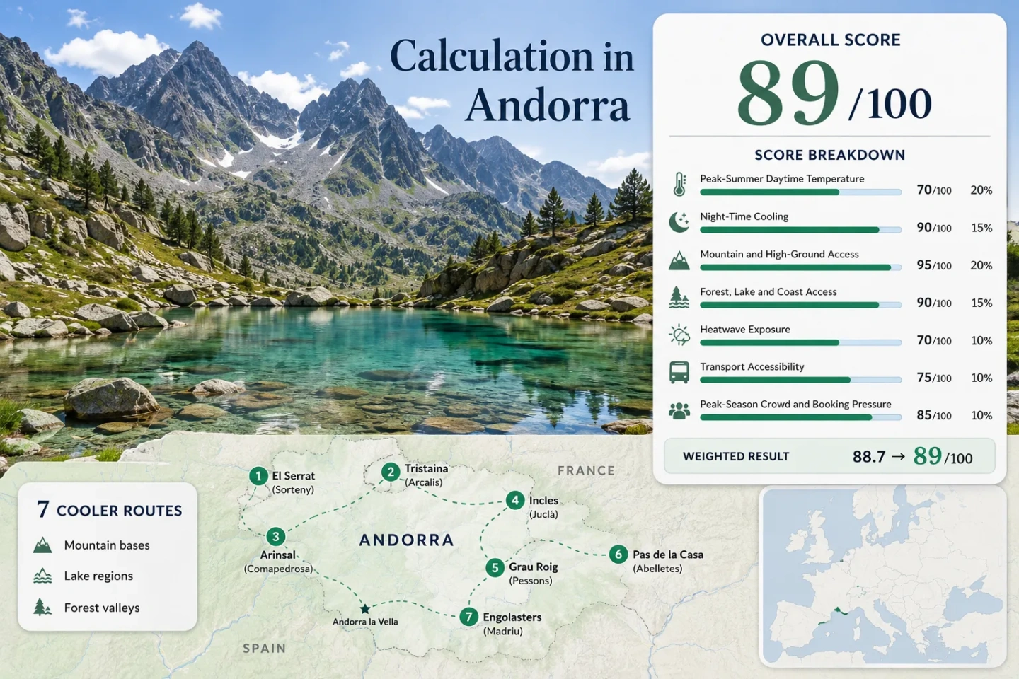
The score, marker map and comparison matrix use the same seven bases from Sorteny to Engolasters.
At about 2,080 metres, it offers the clearest village-level night-cooling advantage in the route set.
The lake sits above the Incles Valley and requires a substantial climb from the summer access point.
L3–L6 services reach several village bases, although Sorteny, Tristaina and Engolasters still involve a last-mile transfer or walk.
Incles restricts ordinary summer traffic, while the Tristaina approach changes during gondola operating hours.
High starts reduce heat exposure but increase sensitivity to afternoon convection, wind and rapid cloud build-up.
High Valleys, Lake Shelves and Village Bases Across Andorra
The route set runs from the forested northern valleys to open high ground near the French border. Marker numbers match the destination cards and the comparison matrix.
Markers show planning centres for the selected cooler-route regions, not guaranteed legal parking, exact viewpoints or trailheads. Use the access notes and Google Maps links in each route card before travelling.
Andorra High-Ground Cooler Escape Suitability Score
This transparent editorial suitability index uses disclosed climate, landscape, access and peak-pressure factors for the seven routes shown here. It is not an official climate classification or a weather forecast.
Method: Route-centre extraction from the Andorran Digital Climate Atlas monthly mean-maximum temperature layers. July and August values were averaged for each marker centre, then the seven-route median was normalised with the fixed daytime-temperature scale.
Raw: 22.7°C route median.
Route values: Sorteny 22.8°C; Tristaina 21.0°C; Arinsal–Comapedrosa 22.8°C; Incles–Juclà 22.7°C; Grau Roig–Pessons 22.0°C; Pas–Abelletes 21.7°C; Engolasters–Madriu 25.0°C.
Source mapping: Each value uses the public planning-marker coordinate rather than a claimed trailhead thermometer. The ACDA model combines station observations, elevation and spatial interpolation; its published monthly mean-maximum model error is approximately ±0.9°C.
Period: July–August climate normal, 1981–2010.
Sources: Andorran Digital Climate Atlas methods and quality; ACDA climate-map catalogue.
Method: Route-centre extraction from the ACDA monthly mean-minimum temperature layers for July and August. The seven-route median was interpolated on the fixed night-cooling scale, which rewards overnight relief without treating very cold nights as automatically preferable.
Raw: 7.1°C route median.
Route values: Sorteny 7.1°C; Tristaina 5.3°C; Arinsal–Comapedrosa 7.2°C; Incles–Juclà 7.1°C; Grau Roig–Pessons 6.4°C; Pas–Abelletes 6.1°C; Engolasters–Madriu 9.3°C.
Source mapping: Values represent modelled route-centre climate normals, not record lows or a guarantee for a particular lodging. The ACDA publishes an approximate ±1.7°C monthly model error for mean-minimum temperature.
Period: July–August climate normal, 1981–2010.
Sources: Andorran Digital Climate Atlas methods and quality; ACDA climate-map catalogue; Andorran diurnal-range and mountain-breeze study.
Method: Fixed categorical rubric based on overnight-base elevation and regular access to terrain above 1,500 metres within 60 minutes.
Raw: Median route category 100.
Route scores: Sorteny 100 — El Serrat is already a high base and the park rises quickly above 1,800 m; Tristaina 100 — gondola and road access reach the 2,000 m band; Arinsal–Comapedrosa 100 — the village opens directly into a 2,942 m mountain park; Incles–Juclà 100 — the valley base gives immediate access to high lake terrain; Pessons 100 — Grau Roig begins around 2,100 m; Pas–Abelletes 100 — the village base is around 2,080 m; Engolasters–Madriu 100 — the lake and valley approaches reach meaningful high ground within the route zone.
Period: Access status reviewed July 18, 2026.
Sources: Tristaina trail information; Comapedrosa route information; Juclà route information; Pessons route information; Abelletes route information.
Method: Fixed access rubric measuring whether strong forest, lake or river systems can be reached within 30 minutes of each route base. Scenic quality is not scored.
Raw: Median route category 100.
Route scores: Sorteny 100 — conifer forest and river valley; Tristaina 75 — major alpine lake access but limited tree cover; Arinsal–Comapedrosa 100 — forested approach plus streams and high lakes; Incles–Juclà 100 — forest, river and large lake system; Pessons 100 — repeated lake basins and forest edge; Pas–Abelletes 75 — direct lake access in open alpine ground; Engolasters–Madriu 100 — reservoir, forest and the Madriu river valley.
Period: Physical access and current visitor information reviewed July 18, 2026.
Sources: Sorteny forest route; Tristaina lakes; Juclà lake; Pessons lakes; Andorra lake access information.
Method: Proxy Dataset calculation using ERA5-Land daily maximum temperature at the seven public marker coordinates. Only July and August dates from the ten completed summers 2016–2025 were retained, and days at or above 30°C were counted.
Raw: 0.3% route median.
Route values: Sorteny 2/620 days, 0.3%; Tristaina 0/620, 0.0%; Arinsal–Comapedrosa 3/620, 0.5%; Incles–Juclà 7/620, 1.1%; Grau Roig–Pessons 0/620, 0.0%; Pas–Abelletes 0/620, 0.0%; Engolasters–Madriu 16/620, 2.6%.
Coverage: 620 valid days from 620 expected days at each route centre. The proxy describes grid-cell temperature exposure and can smooth steep local elevation differences; it does not replace an on-site thermometer.
Period: July–August 2016–2025; daily maximum temperature in °C; 30°C threshold.
Sources: Open-Meteo Historical Weather API documentation; reproducible seven-coordinate ERA5-Land query.
Method: Fixed transport rubric based on direct national bus access, transfer complexity and the need for seasonal last-mile transport.
Raw: Median route category 80.
Route scores: Sorteny 80 — L6 corridor plus parish summer bus from El Serrat; Tristaina 60 — bus corridor followed by resort transfer or seasonal lift access; Arinsal–Comapedrosa 100 — direct L5 service to the village trail base; Incles–Juclà 80 — L3/L4 corridor plus valley electric train or walk; Pessons 80 — L4 corridor with a final approach at Grau Roig; Pas–Abelletes 100 — direct L4 service and a village-edge trail; Engolasters–Madriu 60 — L2 corridor plus local road, transfer or additional walking.
Period: Timetables and summer access arrangements reviewed July 18, 2026.
Sources: L6 Ordino corridor; L5 Arinsal service; L3 Soldeu and Grau Roig corridor; L4 Pas de la Casa service; L2 Encamp service; Sorteny summer access.
Method: Capacity-pressure fallback using official parking limits, road controls, lift dependence and seasonal visitor-management measures. No unsupported occupancy percentage is used.
Raw: Median route category 60.
Route scores: Sorteny 40 — 50-space park and paid July–August management; Tristaina 40 — controlled road access and lift-hour concentration; Arinsal–Comapedrosa 80 — regular village capacity without a formal trail reservation; Incles–Juclà 40 — road closure shifts visitors onto a limited electric-train and walking corridor; Pessons 60 — resort car park and weekend concentration; Pas–Abelletes 80 — direct village access without formal reservation; Engolasters–Madriu 60 — easy road access can create weekend pressure around the lake.
Period: 2026 summer access rules and the latest published capacity information available on July 18, 2026.
Sources: Sorteny parking and summer bus information; Ordino Arcalís 2026 summer operations; Tristaina road restrictions; Incles summer access note.
Seven High Bases for Lakes, Shade and Cooler Nights
The routes are not interchangeable. Some begin in forest, some depend on controlled valley transport, and others trade shade for immediate access to open terrain above 2,000 metres.
El Serrat and Sorteny Valley
El Serrat is a practical northern base for entering Sorteny’s conifer forest and river corridor before the path opens into higher botanical meadows. The Canya de la Rabassa–Pla de Sorteny route covers about 4.9 km with roughly 225 metres of ascent, making it the least demanding shaded option in the set.
Peak-season access: The park information point lists a 50-space car park, paid management in July and August, and a low-cost parish bus from El Serrat. That makes an early bus connection more predictable than arriving by car near midday.
Tristaina Lakes and Ordino Arcalís
The Tristaina circuit concentrates several glacial lakes into a short high-altitude loop with about 201 metres of ascent and descent. The open bowl gives little midday shade, but its elevation keeps the thermal profile markedly different from the central valley.
2026 access pattern: The Creussans gondola operates on selected June weekends, daily from June 20 to September 13, and again on selected autumn weekends. During operating days, private-road access changes between 08:30 and 17:00, so the lift timetable is part of the route plan rather than an optional extra.
Arinsal and Comapedrosa Park
Arinsal combines a high village overnight base with direct entry into Andorra’s highest mountain landscape. The full Comapedrosa ascent is a serious 15.4 km mountain day, while the shorter interpretive circuit offers a lower-commitment alternative that still uses the park’s forested lower slopes.
The village is one of the stronger car-light bases because the national L5 line reaches Arinsal directly. Accommodation sits lower than the summit terrain, but evening temperatures remain more favourable than in Andorra la Vella, and trail access does not require a separate resort lift.
Incles Valley and Juclà Lake
Incles is one of Andorra’s clearest forest-to-lake transitions. The lower valley supplies shade and river air, while the Juclà route climbs to the country’s largest lake, where the landscape becomes open and alpine.
Ordinary traffic is restricted on the valley road in summer. Access shifts to the electric train or a longer walk from the lower entry, so the nominal trail time does not describe the whole day. The official route estimate gives about 2 hours 10 minutes for the ascent and 1 hour 40 minutes for the descent.
Grau Roig and the Pessons Lake Cirque
Grau Roig begins high enough that the cool-air benefit is immediate rather than earned after a long valley climb. The Pessons basin links a sequence of lakes beneath a broad granite cirque, with route choices ranging from the short Estany Primer approach to a longer circuit through the upper lake system.
Tree cover is strongest near the lower approach and becomes sparse quickly. On clear days, elevation limits heat exposure; on unstable days, the same open bowl offers little shelter from wind, hail or lightning.
Pas de la Casa and Abelletes Lake
Pas de la Casa is the clearest overnight choice when low night-time temperatures matter more than forest atmosphere. The short Abelletes route starts near the village, rises only about 120 metres and reaches a small cross-border lake shared by Andorra and France.
The route is open and largely unshaded, yet its starting altitude means even a brief walk remains within the high Pyrenean climate band. Direct L4 bus service also makes it the simplest high-elevation option for travellers without a car.
Engolasters Lake and the Madriu Valley
Engolasters sits lower than the high eastern routes but compensates with forest cover, water and access to the Madriu-Perafita-Claror valley. The 4.9 km Coll Jovell itinerary adds about 250 metres of ascent, while the Camí de les Pardines provides a gentler shaded approach from the Encamp side.
The lake is a reservoir and swimming is prohibited, so its value is shade, walking access and a cooler forest setting rather than water recreation. It is also the route most exposed to warm spillover from the central valley during strong heat events.
Two Mountain Roads That Change Their Role in Summer
The Incles and Tristaina valleys cannot be treated as ordinary drive-to-trailhead routes during the main season. Their access controls redistribute visitors into timed transport corridors.
Incles: Road Closure Becomes Part of the Walk
The summer closure removes ordinary private traffic from the upper valley. The electric train shortens the approach, but walkers who miss it add road distance before the Juclà ascent begins. A cool morning can therefore become a long exposed return if the last-mile schedule is ignored.
Tristaina: Gondola Hours Shape Arrival Waves
On 2026 operating days, the gondola runs from 08:30 to 17:00 and private-road access changes during the same window. Starting near opening time reduces uncertainty, while a late-afternoon return must allow for the final descent and transport cutoff.
Sorteny: Fifty Spaces Favour the Parish Bus
The park’s 50-space car park is a meaningful capacity constraint in July and August. The parish bus from El Serrat is not merely an environmental alternative; it is the more reliable way to avoid circling for a space during peak arrival hours.
From Sorteny Pine Shade to the Open Cirques Above 2,000 Metres
Elevation and shade do different jobs. High open basins suppress temperature through altitude, while conifer valleys reduce direct solar load even when their air temperature is slightly higher.
Forest-First Routes
Sorteny, lower Incles, Arinsal and the Engolasters–Madriu approaches begin beneath conifers. Andorra’s meteorological climate material notes that forest cover reduces incoming solar radiation and moderates daytime maxima, making these routes more forgiving when cloud cover is limited.
Open Alpine Routes
Tristaina, Pessons and Abelletes begin high but provide little continuous shade. They work through altitude rather than canopy, so hats, water and an early start remain necessary even when the air feels cool.
Mixed Forest-to-Lake Routes
Juclà and Comapedrosa change character during the day: shaded lower sections give way to exposed upper terrain. The ideal pacing uses the forest during the morning climb and avoids crossing the open lake or summit zone after storm clouds begin to build.
All Seven Routes by Effort, Last-Mile Access and Heat Relief
Every route used in the score appears here. The final column identifies the type of hot-day fallback each zone offers rather than treating every lake or village as equivalent.
| Route zone | Key route measure | Last-mile pattern | Shade or water | Hot-day use |
|---|---|---|---|---|
| El Serrat and Sorteny | 4.9 km; about +225 m | L6 corridor plus parish bus | Strong forest and river shade | Lower-effort shaded walking |
| Tristaina and Ordino Arcalís | 4.4 km; high point about 2,330 m | Controlled road and seasonal gondola | Multiple lakes; little tree cover | Short high-altitude circuit |
| Arinsal and Comapedrosa | 15.4 km full summit route; 2,942 m peak | Direct L5 to village | Forested lower park, exposed summit | Cool overnight base; early long hike |
| Incles and Juclà | About 2 h 10 ascent; 21.3 ha lake | Bus corridor plus electric train or walk | Forest, river and high lake | Full-day forest-to-lake transition |
| Grau Roig and Pessons | Base around 2,100 m; nine-lake basin | L4/L3 corridor plus resort approach | Lake-rich; limited upper shade | Immediate high start without valley heat |
| Pas de la Casa and Abelletes | 808 m route; about +120 m | Direct L4 to village | Small lake; open terrain | Short walk and coolest sleeping base |
| Engolasters and Madriu | 4.9 km Coll Jovell route; about +250 m | L2 corridor plus transfer or walk | Reservoir and continuous forest sections | Accessible shade near the central valley |
Long Summer Light Does Not Remove the Afternoon Storm Deadline
Late-June and July daylight makes long mountain days possible, but it should not be used to justify a late start. In the Pyrenees, the practical deadline is often cloud development rather than sunset.
Late June to Early July
Long daylight supports extended valley walks, yet lingering snow or wet ground can remain on high lake approaches. Tristaina lift operations become daily from June 20 in the 2026 schedule, improving access before the main August pressure period.
Late July and August
This is the strongest period for open high trails but also the period with the most transport concentration, paid parking management and warm central-valley afternoons. Start exposed circuits first and reserve shaded routes for days with a stable but hotter forecast.
September Transition
Cooler nights return quickly, while lift and road arrangements begin to narrow after September 13 at Ordino Arcalís. The reduced crowd load is useful, but shorter service windows and earlier weather deterioration require more conservative timing.
Planning rule: Check the official mountain forecast on the morning of travel, begin open lake circuits before the central valley warms, and keep Sorteny or Engolasters as shaded alternatives when the upper ridges show unstable cloud development.