Spain Away from the Heat: Northern Coasts, Green Mountains and Atlantic Cities
Northern Spain replaces Mediterranean heat with a more changeable Atlantic pattern: milder coastal afternoons, cooler nights in Galicia and Asturias, green mountain access behind the Cantabrian shore, and city bases linked by rail. The trade-off is real—cloud, rain, humidity and brief southerly heat bursts remain part of July and August planning.
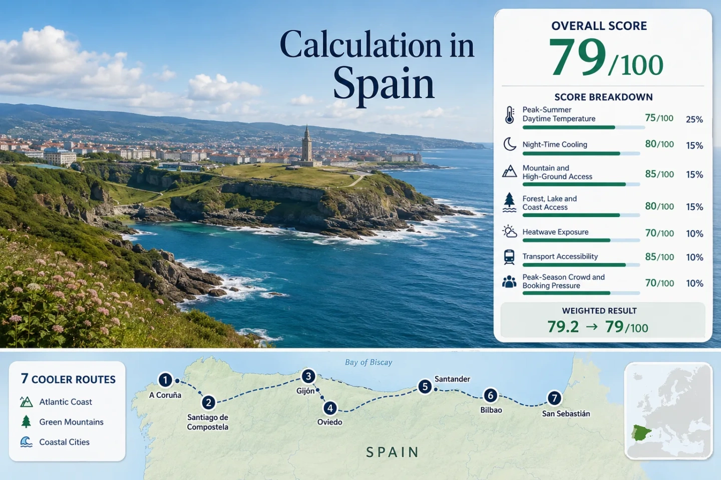
The route set runs from A Coruña to San Sebastián and uses the same places in the map, score and comparison.
Median July–August average maximum from the mapped AEMET station set; individual routes range from about 22.2°C to 25.7°C.
The selected bases usually retain meaningful overnight relief, although humid or southerly episodes can interrupt it.
The exposed Igeldo station averages about 22.2°C for July–August daytime maxima, with a strong maritime bias.
A 336 m urban station and practical links toward the central Asturian ranges create the clearest city-to-mountain temperature gradient.
Atlantic moderation comes with wetter days, coastal fog and concentrated demand around pilgrimage, beach and festival periods.
Atlantic City Bases from Galicia to the Basque Coast
The markers follow a west-to-east chain of rail-connected cities with immediate coast, green hinterland or mountain-day-trip potential.
Markers show selected cooler-route regions and planning centers, not guaranteed legal parking, trailheads or exact viewpoints. Use each route card for Google Maps links and access notes before traveling.
Northern Spain Cooler Escape Suitability Score
This transparent editorial suitability index uses disclosed climate, landscape, access and pressure factors. It is not an official climate classification or a weather forecast.
The score is calculated from the seven mapped routes with equal route weight and median aggregation. Route count creates no bonus.
Atlantic City Bases with Mountain and Coastal Reach
Each base has a different balance of daytime moderation, night cooling, rain exposure and access to higher terrain.
A Coruña and the Costa Ártabra Edge
July–August station normal: about 22.5°C by day and 16.2°C at night at the urban AEMET station, 58 m above sea level. The exposed peninsula catches Atlantic wind from several directions, while the compact center remains workable without a car.
Fragas do Eume and the northern rías add forest and estuary relief, but serious mountain elevation is not close enough to function as a rapid heat-wave backup.
Santiago de Compostela as a Forested Inland Base
The same airport station averages about 24.5°C for daytime maxima. It sits near 370 m, roughly 10 km east-northeast and about 100 m above the historic center, so central afternoons can differ. Dense green corridors, the Sar and Ulla catchments and frequent regional trains support car-light travel.
High mountain terrain is not immediate; the route works more through night cooling, shade and access to Galicia’s coast than through altitude.
Gijón Between the Bay and the Asturian Rail Belt
Gijón pairs a sea-level waterfront with roughly 22.8°C average July–August maxima and 16.5°C minima. The beach, cliff paths and green outskirts are immediate, while the Cantabrian range rises farther south.
Mid-August is the main pressure point; lodging and restaurant demand can rise even when the weather remains moderate.
Oviedo for Central Asturian High-Ground Access
Oviedo’s urban AEMET station stands at 336 m and averages about 23.1°C by day and 14.7°C at night in July–August. That elevation is modest, but it produces a stronger overnight profile than most coastal bases.
Southerly flow can warm the interior city faster than Gijón. Keep a coastal or higher-valley alternative for those episodes.
Santander Bay with Liébana Beyond the Coast
The representative airport station across the bay averages about 23.9°C maxima and 16.2°C minima for July–August. Bay exposure, open beaches and green valleys make water access immediate; high Picos terrain requires a longer transfer toward Liébana.
Watch for: Humid air can reduce the subjective benefit of a moderate thermometer reading, and beach-week accommodation pressure rises sharply in August.
Bilbao’s Estuary, Transit Network and Heat Trade-Off
Bilbao is the warmest daytime base in the set: the airport representative station averages about 25.7°C for July–August maxima and 15.6°C for minima. The city core can run warmer than the airport under sheltered or southerly conditions.
The route offers the broadest urban transport system, not the lowest heat exposure. Brief very hot episodes remain possible despite a moderate long-term mean.
San Sebastián under Igeldo’s Maritime Signal
The exposed Igeldo station, around 251 m and roughly 5 km west of the center, averages about 22.2°C maxima and 16.3°C minima in July–August. It captures maritime moderation well but can be cooler, windier and wetter than sheltered streets around the bay.
July and August require early lodging decisions. A forecast check is especially important when southerly wind temporarily overrides the usual sea influence.
Heat, Night Cooling and Car-Light Reach by City Base
The temperature column uses July–August station normals; the remaining fields separate city access from mountain-day-trip practicality.
| Route | Normal max / min | Higher-ground link | Car-light city use | Main peak pressure |
|---|---|---|---|---|
| A Coruña | 22.5°C / 16.2°C | Low Atlantic hills; major ranges distant | Strong | Coastal weekends and events |
| Santiago de Compostela | 24.5°C / 13.2°C | Galician uplands; no rapid alpine-scale rise | Strong | Camino arrivals around July 25 |
| Gijón | 22.8°C / 16.5°C | Cantabrian range via road transfer | Strong | Mid-August city and beach demand |
| Oviedo | 23.1°C / 14.7°C | Central Asturias, Pajares and Somiedo-facing roads | Strong in city; mixed for highlands | Moderate outside event weekends |
| Santander | 23.9°C / 16.2°C | Liébana and Picos by longer transfer | Strong in city | August beach weeks |
| Bilbao | 25.7°C / 15.6°C | Gorbeia and inland Basque high ground | Very strong | Events and coast-bound weekends |
| San Sebastián | 22.2°C / 16.3°C | Jaizkibel and Aiako Harria nearby | Very strong | High July–August booking pressure |
Cantabrian Sea Air Can Reverse under Southerly Flow
The northern coast is historically milder, but its cooling mechanism is directional rather than permanent.
A Coruña, Santander and Igeldo Benefit from Exposure
Open-water wind and lower average maxima support daytime moderation. The same exposure increases cloud, wind and rain, so a 22–24°C day may not function as a conventional beach day.
Bilbao and Inland Streets Can Warm Faster
Bilbao’s estuary and sheltered center can separate from its airport station. Santiago and Oviedo also lose some direct sea influence, trading warmer afternoons for cooler nights or easier inland access.
South-Wind Episodes Need a Backup Route
Föhn-type flow can produce short, sharp heat on the Cantabrian side. During those windows, an exposed beach, shaded forest or higher Asturian route is more useful than relying on the city’s long-term average.
The Northern Rail Spine Stops Short of Many High Valleys
Rail makes the seven city bases practical without a car, but the final climb into protected mountain country follows a different transport logic.
Galicia Favors Intercity Hops
A Coruña and Santiago are straightforward rail bases. Coastal rías, forest parks and dispersed viewpoints often require regional buses, taxis or a carefully planned rental day.
Asturias and Cantabria Use Slower Local Lines
Cercanías and former FEVE routes connect many northern settlements, but journey times are slower than the map distance suggests. Somiedo and Liébana still need road-based final legs.
The Basque Coast Has the Densest Local Network
Metro, Euskotren and regional rail make Bilbao and San Sebastián strong car-light bases. Gorbeia and scattered Aiako Harria trailheads remain easier with a targeted bus plan or vehicle.
July 25, August Festivals and Beach-Week Pressure
Northern Spain’s temperature window overlaps with concentrated cultural and coastal demand, so the lowest-heat choice is not always the lowest-friction choice.
Late July Concentrates Santiago Demand
The period around July 25 intensifies pilgrimage arrivals, central-city foot traffic and room demand. A Coruña provides a practical Atlantic alternative when Santiago availability tightens.
Mid-August Pressures the Asturias–Basque Arc
Gijón and San Sebastián combine festival calendars with beach demand; Santander also tightens during settled coastal weeks. Oviedo usually offers more booking resilience.
Late August Improves the Access–Pressure Balance
Daylight remains generous and mountain access is generally open, while family-holiday pressure can begin to ease. Rain risk does not disappear, and event dates vary by year.
North-Coast Checks Before Crossing Three Weather Regions
Galicia, Asturias–Cantabria and the Basque coast can sit under different cloud, wind and heat conditions on the same day. Check AEMET warnings, the local hourly forecast and Renfe service information before committing to a long west–east transfer. For mountain days, confirm road, park and bus access separately; a city rail ticket does not guarantee a workable trailhead connection.