France Beyond the Heat: Alpine Lakes, Atlantic Towns and Mountain Summers
France’s cooler summer options are geographically split. Atlantic towns use ocean exposure, cloudier intervals and sea breezes to moderate daytime heat, while Alpine and Jura bases rely on elevation, rapid access to higher ground and stronger night-time cooling. The route set combines rail-connected lake towns, high valleys, exposed western coasts and a 940-metre Jura village rather than treating France as one uniform summer climate.
Three Atlantic bases, three Alpine lake or valley bases and one high Jura village. Route count adds no score bonus.
Brest-Guipavas has a July–August mean daily maximum close to 20.9°C in the 1991–2020 station normal.
The 940-metre Haut-Doubs base has a July–August mean daily minimum near 8.7°C, requiring warmer evening layers.
Rail access, lake swimming and nearby mountain roads create flexibility, although the low basin can still become hot.
Mainline rail reaches the valley base, with the Les Arcs funicular and summer lifts providing seasonal access above 1,600 metres.
Atlantic exposure moderates many days, but Biarritz and Île de Ré face concentrated July–August demand.
Atlantic Shores, Alpine Valleys and the High Jura
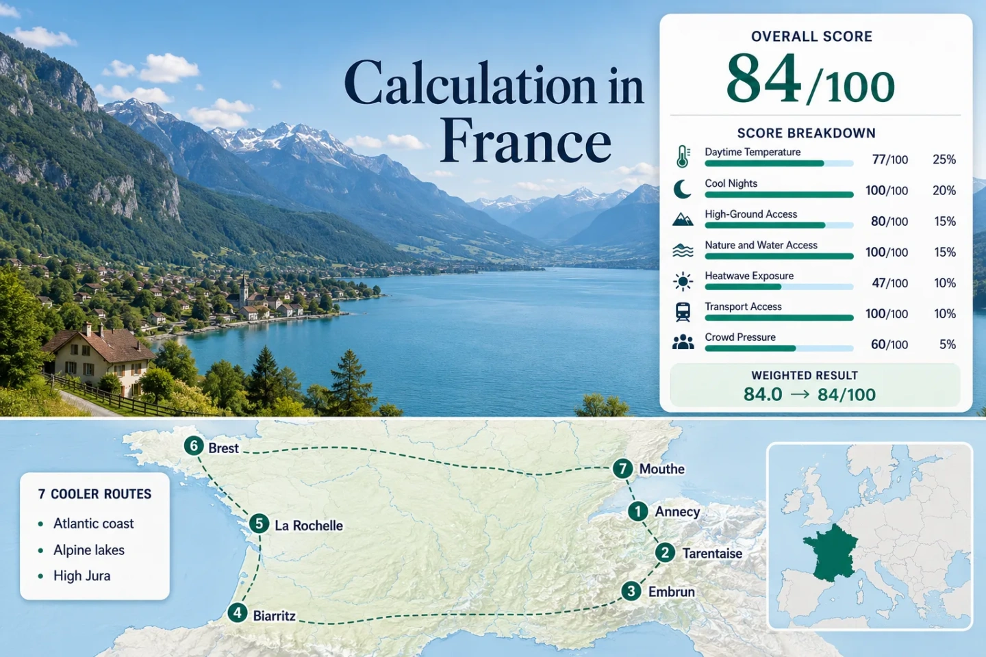
The markers connect seven distinct summer-comfort systems: Finistère’s exposed coast, the Basque and Charente shores, Lake Annecy, the Tarentaise valley, Serre-Ponçon and the elevated Haut-Doubs plateau.
Markers show selected cooler-route regions and planning centres, not guaranteed legal parking, trailheads or exact viewpoints. Use the route links and current local access information before travelling.
France Alpine and Atlantic Cooler Escape Suitability Score
This transparent editorial suitability index uses disclosed climate, landscape, access and pressure factors. It is not an official climate classification, a heat-safety rating or a weather forecast.
Weighted total: 77×0.25 + 100×0.20 + 80×0.15 + 100×0.15 + 47×0.10 + 100×0.10 + 60×0.05 = 84.0 → 84/100
Method: Every route carries equal weight within each factor. Route-level values are combined by median before the seven fixed factor weights are applied. A larger route portfolio does not increase the score.
Alpine Lakes, Atlantic Bases and High-Plateau Summers
The portfolio deliberately includes places with different limitations. Brest is mild but wetter and windier; Annecy offers water and mountain access but not guaranteed low daytime temperatures; Mouthe cools sharply after sunset but has thinner public transport.
Annecy and Lake Annecy
Lake base: Approximately 448 metres. Annecy-Meythet’s 1991–2020 July–August normals average about 26.3°C by day and 14.3°C at night. The lake, rail station and surrounding Bauges and Bornes foothills create several ways to change elevation or activity without changing accommodation.
Lake swimming and cycling are easy to combine with higher roads, but the basin itself is not a refuge during every heat event. Moving upward early in the day matters more than assuming the waterfront will remain cool.
Bourg-Saint-Maurice and Haute Tarentaise
The railway base sits near 800–865 metres, while the funicular reaches Arc 1600 and seasonal lifts extend access farther into the Les Arcs mountain domain. Station normals place the July–August daytime mean maximum near 26.6°C, but mean nights remain close to 12.8°C.
The value lies in vertical mobility rather than a uniformly cold valley floor. A hot afternoon in Bourg-Saint-Maurice can be answered with a higher trail, shaded forest sector or lift-assisted route when the operating calendar permits.
Embrun and Lake Serre-Ponçon
Base elevation: About 870 metres. July–August normals: Roughly 27.8°C by day and 13.3°C at night. Water system: The 2,800-hectare Serre-Ponçon reservoir provides swimming and water-based alternatives within an Alpine setting.
Embrun is sunnier and more heat-exposed than Brest, Biarritz or Mouthe. Its advantage is the combination of cool nights, lake access and roads toward higher terrain rather than low daytime averages.
Biarritz and the Basque Coast
At the Biarritz-Anglet station, the July–August daily maximum normal averages about 24.7°C and the daily minimum about 17.1°C. Atlantic exposure limits many daytime peaks, but humid nights and occasional hot southerly flow make the coast feel different from a high mountain base.
Rail, airport and urban buses make Biarritz one of the easiest low-car choices in the set. Beaches and coastal walks are close, while higher Pyrenean terrain generally requires a separate inland transfer.
La Rochelle and Île de Ré
Coastal normal: Approximately 24.8°C by day and 16.4°C at night for July–August at La Rochelle Aérodrome. Arrival: Mainline rail reaches La Rochelle. Island access: Bus, bridge and seasonal boat options distribute movement toward Île de Ré.
The exposed shore can be mild when inland western France is hotter, but the island is not a low-demand retreat during the French school-holiday peak. The local tourist office reports that the island population can exceed 150,000 and identifies pronounced bridge-traffic periods.
Brest and the Crozon Peninsula
Brest-Guipavas records July–August normals near 20.9°C for daily maxima and 13.2°C for minima, the lowest daytime value in this route set. Thirty-degree days are uncommon in the station’s climatological threshold table.
The trade-off is wetter, windier and more changeable weather. Brest works as a connected urban base, while Crozon’s coves, cliffs and walking sectors require bus planning, seasonal links or a vehicle for fuller coverage.
Rain context: The station averages about ten days with at least 1 mm of rain in both July and August, so mild temperature does not equal dry hiking weather.
Mouthe and the Haut-Doubs
At 940 metres, Mouthe has July–August mean maxima near 22.1°C and mean minima near 8.7°C. The low night value creates the strongest evening temperature release in the portfolio, but it can also feel cold after rain or under clear skies.
Forests, the Doubs headwaters and nearby Jura lakes give the route a distinctly inland cooling pattern. Unlike Bourg-Saint-Maurice, the accommodation base is already high; unlike Brest, the mildness does not depend on ocean air.
Which French Cooling System Matches the Trip?
All seven mapped routes are compared using the factors most likely to change a booking decision: daytime heat, night release, water access, car dependence and the main summer limitation.
| Route | July–August Day / Night | Main Cooling Mechanism | Car-Light Strength | Primary Summer Trade-Off |
|---|---|---|---|---|
| Annecy and Lake Annecy | 26.3°C / 14.3°C | Lake access plus rapid movement toward higher Alpine terrain | Strong in town and around major lake corridors | Hot basin afternoons and intensive lakeside demand |
| Bourg-Saint-Maurice and Haute Tarentaise | 26.6°C / 12.8°C | High-valley nights and lift-assisted altitude gain | Strong while summer funicular, lifts and shuttles operate | Valley-floor heat and seasonal lift dates |
| Embrun and Lake Serre-Ponçon | 27.8°C / 13.3°C | Elevated nights, reservoir access and higher Alpine roads | Good at the base; variable around remote shores | Strong sunshine, heat bursts and fire danger |
| Biarritz and the Basque Coast | 24.7°C / 17.1°C | Atlantic airflow and marine moderation | Strong urban and beach-corridor access | Humidity, warmer nights and concentrated demand |
| La Rochelle and Île de Ré | 24.8°C / 16.4°C | Atlantic air, exposed island shores and cycling mobility | Strong to La Rochelle; moderate across the island | Bridge traffic and July–August visitor pressure |
| Brest and the Crozon Peninsula | 20.9°C / 13.2°C | Open Atlantic exposure and frequent maritime airflow | Strong in Brest; weaker across Crozon | Rain, wind and dispersed peninsula access |
| Mouthe and the Haut-Doubs | 22.1°C / 8.7°C | 940-metre plateau base, forest and pronounced night cooling | Limited outside core villages | Cool wet spells and car-dependent local movement |
Why Alpine Bases Still Record Hot Afternoons
Lake Annecy Sits in a Low Basin
Annecy’s water access improves activity choice, but the station normal exceeds 26°C for July–August daytime maxima. The cooling decision is often when to leave the basin, not whether to remain beside the lake all afternoon.
Tarentaise Depends on Vertical Access
Bourg-Saint-Maurice can reach hot daytime values despite its mountain setting. The route becomes materially different when the funicular and lifts are operating, because accommodation at the railhead can be paired with terrain above 1,600 metres.
Embrun Combines Height With Southern Sun
Embrun’s 873-metre station still has the highest daytime normal in the portfolio. Lake access and cool nights strengthen the route, but neither removes the need to plan around strong afternoon sunshine and current fire conditions.
Brest Mildness, Basque Humidity and Île de Ré Traffic
Finistère Exchanges Heat for Wind and Rain
Brest has the lowest daytime normal and the smallest 30°C threshold frequency in the set. It also has roughly ten July rain days and ten August rain days under the station normal. Lower heat does not automatically mean stable outdoor weather.
Basque and Charente Shores Carry More Peak Pressure
Biarritz and La Rochelle remain relatively moderate by day, yet nights are warmer than in Brest, Mouthe or the Alpine valleys. Île de Ré adds a separate capacity issue: official visitor information identifies July–August crowding and specific bridge-traffic peaks.
Lowest Heat, Lift Access and Water Use Do Not Peak Together
Mid-June to Early July
Long daylight and lower school-holiday pressure can favour Annecy, Brest and Biarritz. High Alpine trails may still carry snow, while the Les Arcs lift calendar begins before every high route is necessarily snow-free.
Mid-July to Mid-August
The broadest lift, lake and ferry availability overlaps with the strongest booking and road pressure. Mouthe and Brest offer lower temperature medians, while Annecy, Embrun and Bourg-Saint-Maurice retain meaningful hot-afternoon exposure.
Late August to Mid-September
Shoulder-season pressure often eases before every summer service ends. The 2026 Les Arcs mountain-domain calendar extends to September 13, making early September relevant for high access, though local lift and weather status still requires confirmation.
Forecasts, Lift Status, Fire Danger and Coastal Capacity
Check current Météo-France forecasts and vigilance before committing to exposed coasts, lake activities or high trails. Alpine plans should also confirm lift operation, snow conditions and thunderstorm risk. Serre-Ponçon requires attention to forest-fire information, while Île de Ré and the Basque Coast benefit from checking traffic, parking and seasonal transport before arrival.