Liechtenstein Coolcation: Alpine Trails, Rhine Valley Breezes and High Villages
Liechtenstein compresses a remarkable elevation change into a small travel area: the Rhine plain sits near 440–460 metres, while Malbun provides an overnight base at about 1,600 metres and marked trails continue above 2,300 metres. The result is a flexible summer pattern of warm valley mornings, shaded forest climbs, breezier high villages and substantially cooler nights without a long cross-country transfer.
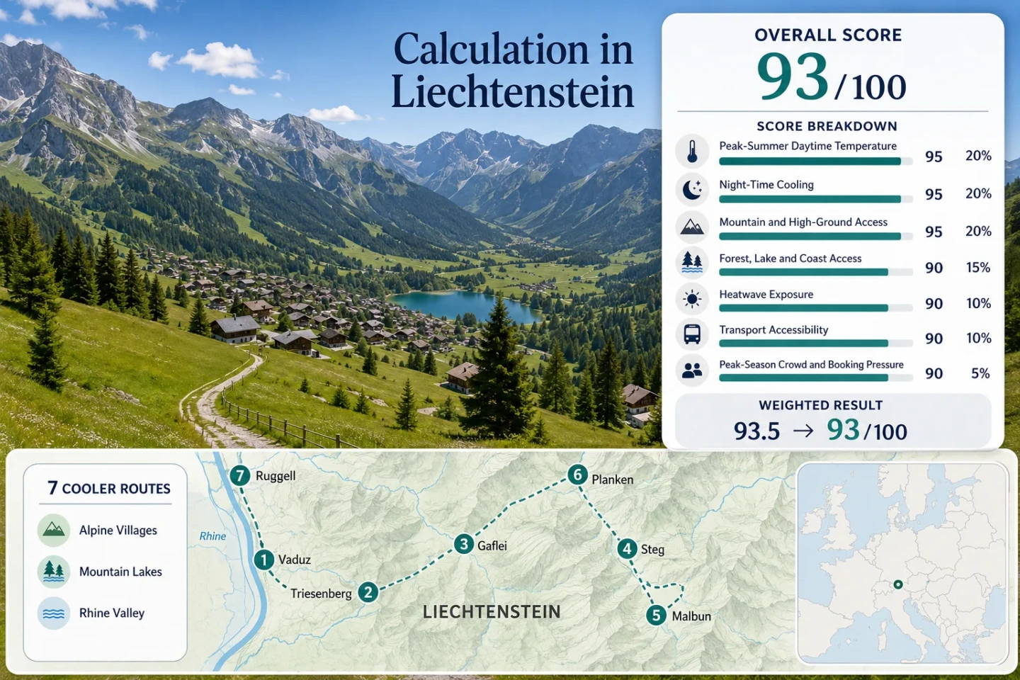
The assessed overnight and walking bases extend from Ruggell on the Rhine plain to Malbun’s high Alpine basin.
Liechtenstein Tourism reports roughly 400 kilometres of maintained trails across a national area of about 160 square kilometres.
The main bus corridor links Vaduz, Triesenberg, Steg and Malbun, allowing lowland and high-altitude stops in one day.
The Fürstin-Gina-Weg reaches Augstenberg above Malbun on an official 11.9-kilometre mountain route.
An average of 4.2 hotels operated in the Steg–Malbun area during 2025, making availability more concentrated than national occupancy alone suggests.
The score, marker map and decision table use the same seven valley, village, wetland and high-mountain route areas.
From the Rhine Floor to Malbun’s High Basin
The markers show how quickly the route set rises from flat Rhine-side paths to forested slopes, Alpine lakes and high trailheads. The numbered sequence matches the route cards and comparison table.
This marker map is built for planning orientation. Marker positions use approximate public location centres where exact viewpoints, trailheads, legal parking areas or path entrances are not specified. Use the route cards for Google Maps links and confirm current access information before travelling.
Liechtenstein Alpine and Rhine Suitability Score
A transparent editorial suitability index based on disclosed climate, landscape, access and pressure factors. It is not an official climate classification or a weather forecast. Each route carries equal weight, and route count adds no score bonus.
Method: Representative-station calculation. Vaduz station VAD anchors the 1991–2020 July–August baseline; higher route centres receive a transparent 0.6°C per 100-metre elevation adjustment for editorial comparability. These are route proxies, not official station observations for every village.
Raw: Route median 22.1°C, normalised to 95/100.
Route values: Vaduz and the Rhine Embankment 24.6°C; Triesenberg and Gnalp 22.1°C; Gaflei and the Philosophenweg 18.5°C; Steg and Gänglesee 19.6°C; Malbun and the Fürstin-Gina-Weg 17.8°C; Planken and the Gafadura Approach 22.6°C; Ruggell and the Ruggeller Riet 24.7°C.
Source mapping: Vaduz uses direct station VAD at about 460 metres. Ruggell is a near-level valley representative. Planken, Triesenberg, Gaflei, Steg and Malbun use the same official baseline with disclosed elevation adjustment because equivalent route-level long-term stations were not identified.
Period: July–August, 1991–2020.
Sources: MeteoSwiss climate normals; MeteoSwiss spatial climate-normal documentation.
Method: The same representative-station and elevation-adjustment method is applied to average July–August minimum temperature.
Raw: Route median 12.1°C, inside the 10–16°C full-score band.
Route values: Vaduz and the Rhine Embankment 14.6°C; Triesenberg and Gnalp 12.1°C; Gaflei and the Philosophenweg 8.5°C; Steg and Gänglesee 9.6°C; Malbun and the Fürstin-Gina-Weg 7.8°C; Planken and the Gafadura Approach 12.6°C; Ruggell and the Ruggeller Riet 14.7°C.
Source mapping: Station VAD is direct for Vaduz and representative for the remaining route centres. The largest elevation difference is between VAD and Malbun, approximately 1,140 metres.
Period: July–August, 1991–2020.
Sources: MeteoSwiss climate normals; Liechtenstein climate profile.
Method: Fixed elevation-and-access rubric applied separately to every route, followed by the route median.
Raw: Median route score 100.
Route scores: Vaduz and the Rhine Embankment 100 — regular Line 21 access to terrain above 1,500 metres; Triesenberg and Gnalp 100 — Gnalp and higher trail access within the route; Gaflei and the Philosophenweg 100 — 1,483-metre base beside higher paths; Steg and Gänglesee 100 — 1,301-metre base with immediate Alpine access; Malbun and the Fürstin-Gina-Weg 100 — 1,600-metre village base; Planken and the Gafadura Approach 80 — 786-metre base with higher slopes nearby; Ruggell and the Ruggeller Riet 60 — lowland base requiring a longer transfer to high terrain.
Route rationale: Liechtenstein’s compact bus network prevents the lowland routes from being isolated from high ground, while Malbun, Gaflei and Steg begin inside the mountain zone.
Period: Access reviewed 18 July 2026.
Sources: Liechtenstein Tourism hiking network; LIEmobil timetable information.
Method: Fixed physical-access rubric measuring proximity to substantial forest, lake, wetland or river systems rather than scenery quality.
Raw: Median route score 75.
Route scores: Vaduz and the Rhine Embankment 75 — direct Rhine access; Triesenberg and Gnalp 75 — extensive mountain forest; Gaflei and the Philosophenweg 75 — wooded slope access; Steg and Gänglesee 100 — lake, stream and forest within the same route area; Malbun and the Fürstin-Gina-Weg 75 — Alpine forest and mountain-water access; Planken and the Gafadura Approach 75 — immediate forest slopes; Ruggell and the Ruggeller Riet 100 — Rhine and protected wetland landscape.
Route rationale: Steg and Ruggell combine two strong cooling-related landscape elements, while the other routes have one substantial element within a short walk or local transfer.
Period: Access reviewed 18 July 2026.
Sources: Liechtenstein Tourism hiking information; Official Liechtenstein planning map.
Method: Official threshold-frequency fallback. Approximate route-centre bins were read from the MeteoSwiss 1991–2020 normal map for hot days, defined as daily maximum temperature of at least 30°C. Bin midpoints were converted to an indicative share of the 62-day July–August window.
Raw: Median equivalent approximately 1.5 hot days per year, or 2.4% of the target window, normalised to 88/100.
Route values: Vaduz and the Rhine Embankment about 7 days and 11.3%; Triesenberg and Gnalp about 1.5 days and 2.4%; Gaflei and the Philosophenweg about 0.3 day and 0.5%; Steg and Gänglesee about 0.5 day and 0.8%; Malbun and the Fürstin-Gina-Weg about 0.2 day and 0.3%; Planken and the Gafadura Approach about 1.5 days and 2.4%; Ruggell and the Ruggeller Riet about 7 days and 11.3%.
Source mapping: These are disclosed map-bin estimates rather than claimed daily station counts. Exact valid-day coverage is therefore not applicable to this fallback method.
Period: Official climatological threshold frequency, 1991–2020.
Sources: MeteoSwiss hot-day definition; MeteoSwiss climate-normal maps.
Method: Fixed public-transport rubric applied to the practical starting point of every route.
Raw: Median route score 100.
Route scores: Vaduz and the Rhine Embankment 100 — direct regional buses and flat walking access; Triesenberg and Gnalp 100 — direct Line 21 corridor; Gaflei and the Philosophenweg 80 — public-transport-supported approach followed by walking; Steg and Gänglesee 100 — Line 21 access at Steg Tunnel; Malbun and the Fürstin-Gina-Weg 100 — direct Line 21 terminus area; Planken and the Gafadura Approach 100 — regular LIEmobil connection; Ruggell and the Ruggeller Riet 100 — regular northern bus access.
Route rationale: No assessed route requires a private vehicle as the only normal access method, although service times and final walking distances vary.
Period: 2026 timetable year, reviewed 18 July 2026.
Sources: LIEmobil 2026 network timetable; LIEmobil current timetable notices.
Method: Official-capacity categorical fallback. Comparable July–August route-level occupancy was not available, so 2025 regional room occupancy and the small number of operating Alpine hotels were used to assess pressure direction.
Raw: Median route score 80.
Route scores: Vaduz and the Rhine Embankment 80 — pressure is concentrated around events and weekends; Triesenberg and Gnalp 80 — moderate village capacity; Gaflei and the Philosophenweg 60 — limited nearby lodging and hut capacity; Steg and Gänglesee 60 — small Alpine accommodation pool; Malbun and the Fürstin-Gina-Weg 60 — concentrated high-season lodging supply; Planken and the Gafadura Approach 80 — limited visitor concentration; Ruggell and the Ruggeller Riet 80 — generally dispersed lowland demand.
Route rationale: National 2025 net room occupancy was 48.5%, while the Alpine region recorded 48.1%. Low annual occupancy does not eliminate date-specific pressure because only about 4.2 Alpine hotels operated on average in Steg and Malbun.
Period: Official tourism year 2025, published March 2026.
Sources: Liechtenstein tourism statistics 2025.
Weighted total: 95×0.25 + 100×0.20 + 100×0.15 + 75×0.15 + 88×0.10 + 100×0.10 + 80×0.05 = 92.8 → 93/100
Rhine Paths, Walser Slopes and High Alpine Trailheads
The seven route areas provide different kinds of heat relief. Valley routes offer easy access and riverside air, while Steg, Gaflei and Malbun trade warmer afternoons for cooler nights, steeper walking and more changeable mountain conditions.
Vaduz and the Rhine Embankment
Vaduz works as the easiest arrival base and the practical interchange for Line 21. Flat Rhine embankment paths suit low-effort mornings, while the bus connection makes it possible to leave the warmer valley floor for Triesenberg, Steg or Malbun later in the day.
The route’s cooling advantage comes from open river space and occasional valley airflow rather than altitude. During hot or föhn-influenced periods, afternoons can remain substantially warmer than the high villages.
Triesenberg and Gnalp
Triesenberg occupies a sunnier middle slope above the Rhine, while Gnalp provides a higher starting point for the Philosophenweg. The official circuit is about 12.3 kilometres, takes roughly four and a half hours and rises to approximately 1,597 metres.
Regular bus access keeps the route practical without a car. The village itself can still feel warm in direct afternoon sun, but forest sections and the higher Gnalp–Gaflei corridor provide a clearer altitude advantage.
Gaflei and the Philosophenweg
Gaflei begins close to the elevation where Liechtenstein’s summer character changes decisively. The air is usually cooler than in Vaduz, forest cover becomes more continuous and evening temperatures can fall quickly after sunset.
The Philosophenweg connects the Gaflei and Triesenberg slope system through a mixture of woodland and exposed mountain sections. Its cooling value is strong, but it is not a casual paved promenade: footwear, trail status and storm timing matter.
Steg and Gänglesee
Steg combines one of the strongest landscape-based cooling patterns in the route set: Gänglesee, the Samina water system, surrounding woodland and a high valley floor. The terrain supports short lake walks as well as longer movement into Valüna and the Route 66 corridor.
LIEmobil access at Steg Tunnel reduces the need for parking and supports one-way walking combinations. Summer conditions remain changeable, and the basin can feel cool or damp after rain even when Vaduz is sunny.
Malbun and the Fürstin-Gina-Weg
Malbun provides the clearest overnight altitude advantage. The village sits at about 1,600 metres, with direct Line 21 access and marked routes ranging from shorter local circuits to exposed high-mountain walking.
The Fürstin-Gina-Weg covers about 11.9 kilometres in roughly five hours and reaches Augstenberg at 2,359 metres. A shorter Malbun circuit is about 7 kilometres, takes around two hours and reaches approximately 1,988 metres before descending.
Cool nights are highly likely relative to the Rhine plain, but altitude also brings stronger ultraviolet exposure, rapid cloud development and a greater chance that rain or wind changes the walking plan.
Planken and the Gafadura Approach
Planken occupies a middle elevation below the Three Sisters massif. It is cooler at night than the Rhine plain and provides quick access to forested climbing routes, but its daytime temperature advantage is smaller than at Steg, Gaflei or Malbun.
The Gafadura approach is most useful when forest shade and vertical movement matter more than a level village walk. Public transport reaches Planken, while the final mountain distance is completed on foot.
Ruggell and the Ruggeller Riet
Ruggell is the lowest assessed base and cannot match Malbun or Steg for altitude cooling. Its value lies in level cycling, wetland edges, river proximity and easy northern bus access.
The Ruggeller Riet can feel calmer during early mornings and evenings, but exposed lowland sections offer limited protection during a hot afternoon. A high-village transfer is the more reliable fallback when temperatures approach 30°C.
Seven Bases Across a 1,159-Metre Elevation Change
The most useful distinction is not simply valley versus mountain. Each base combines a different elevation, transport pattern, walking intensity and exposure to afternoon heat.
| Route | Base elevation | July–August max/min proxy | Car-light access | Main cooling mechanism | Main trade-off |
|---|---|---|---|---|---|
| Vaduz and the Rhine Embankment | About 455m | 24.6°C / 14.6°C | Direct regional buses | River corridor and open air | Warm lowland afternoons |
| Triesenberg and Gnalp | About 884–1,201m | 22.1°C / 12.1°C | Direct Line 21 corridor | Middle-slope elevation and forest | Sunny village slopes can still warm |
| Gaflei and the Philosophenweg | 1,483m | 18.5°C / 8.5°C | Bus-supported approach plus walking | High forest and night cooling | Longer trail and weather exposure |
| Steg and Gänglesee | 1,301m | 19.6°C / 9.6°C | Line 21 at Steg Tunnel | Lake, stream, forest and altitude | Cool, damp conditions after rain |
| Malbun and the Fürstin-Gina-Weg | 1,600m | 17.8°C / 7.8°C | Direct Line 21 access | Highest overnight base | Small lodging pool and exposed ridges |
| Planken and the Gafadura Approach | 786m | 22.6°C / 12.6°C | Regular local bus | Forest shade and vertical ascent | Less daytime cooling at village level |
| Ruggell and the Ruggeller Riet | About 441m | 24.7°C / 14.7°C | Regular northern buses | Wetland, river and morning air | Limited shade on exposed lowland paths |
Line 21 Makes a Two-Altitude Day Practical
Liechtenstein’s strongest logistical advantage is the direct transport relationship between the Rhine Valley and the mountain settlements.
Valley Morning, Mountain Afternoon
A journey can begin with a flat Vaduz or Rhine walk and continue through Triesenberg to Steg or Malbun without returning to a railway station or changing to a private car. The same corridor supports an early retreat from the valley when heat builds faster than expected.
Steg and Malbun Serve Different Energy Levels
Steg provides lake and valley walking near the bus stop, while Malbun suits travellers prepared for steeper terrain and higher exposure. The two stops create a useful backup system when cloud, wind or fatigue makes a ridge route unsuitable.
Timetable and Bicycle Capacity Checks
Current departure times should be checked on the travel date, particularly around public holidays and special timetables. Summer bicycle racks can expand route choices, but rack capacity is limited and cannot be treated as guaranteed space.
Föhn Can Reverse the Rhine Valley Breeze
The Upper Rhine Valley is affected by föhn, a downslope wind that can become warm and dry as it reaches lower elevations. A breezy afternoon in Vaduz or Ruggell is therefore not automatically a cool afternoon. Wind direction and air mass matter as much as wind speed.
MeteoSwiss notes that southern föhn stations generally experience a seasonal lull during June, July and August, but individual summer events still occur. When föhn develops, the open Rhine corridor may feel warmer while Gaflei, Steg and Malbun retain a stronger altitude-based night-cooling advantage.
Normal Valley Pattern
Early walking, river exposure and open airflow can make Vaduz and Ruggell comfortable during ordinary summer mornings. Shade becomes more important after midday because the valley bases remain near 440–460 metres.
Föhn-Day Backup
A transfer to Steg or Malbun replaces uncertain lowland breeze cooling with a large elevation gain. High trails still require a weather check because föhn can also increase wind exposure on ridges.
Route 66 Connects Gänglesee, Valüna and Gaflei
Liechtenstein’s Route 66 hut corridor links several of the country’s most useful cool-air landscapes rather than concentrating the trip around one resort. Steg and Gänglesee provide the water-and-forest starting environment, Valüna extends the high-valley character and Gaflei reconnects the route with the Triesenberg slope system.
Gänglesee Entry
The lake area supports a short, low-commitment start. It remains useful when a long hut traverse is unsuitable but valley temperatures make lowland walking unattractive.
Valüna Extension
Moving deeper into Valüna increases distance from roads and services while maintaining the high-valley environment. Food, water, turnaround time and storm development need closer attention.
Gaflei Exit Logic
The Gaflei side allows a one-way mountain day rather than a forced return along the same route. Bus timing determines whether that advantage remains practical.
The 2025 Hotel Numbers Reveal a Small Alpine Supply
Liechtenstein’s 2025 net room occupancy was below 50%, including 48.1% in the Alpine hotel area. That figure can suggest abundant space, but the regional supply averaged only 4.2 operating hotels in Steg and Malbun. A modest increase in weekend, event or hiking demand can therefore affect high-village choice more quickly than a national occupancy percentage implies.
When a Malbun Overnight Matters
Sleeping at 1,600 metres secures the strongest night-cooling pattern and an early trail start without a morning bus transfer. Reserving earlier is sensible when a specific property, room type or trail date matters.
When Vaduz Preserves Flexibility
A Vaduz base provides a larger service environment and keeps several mountain alternatives reachable by bus. It is the more adaptable arrangement when the final hiking area depends on the morning forecast.