Switzerland Coolcation Routes: Alpine Lakes, High Villages and Glacier Air
Switzerland’s strongest summer-cooling pattern appears above the warm lowland cities, where rail-accessible villages sit between roughly 1,000 and 1,800 metres and mountain transport reaches lakes, glacier valleys and passes above 2,000 metres. The selected July–August routes combine cool nights, high lodging bases and car-light access, while preserving realistic trade-offs around thunderstorms, lift timetables, rain and peak-season capacity.
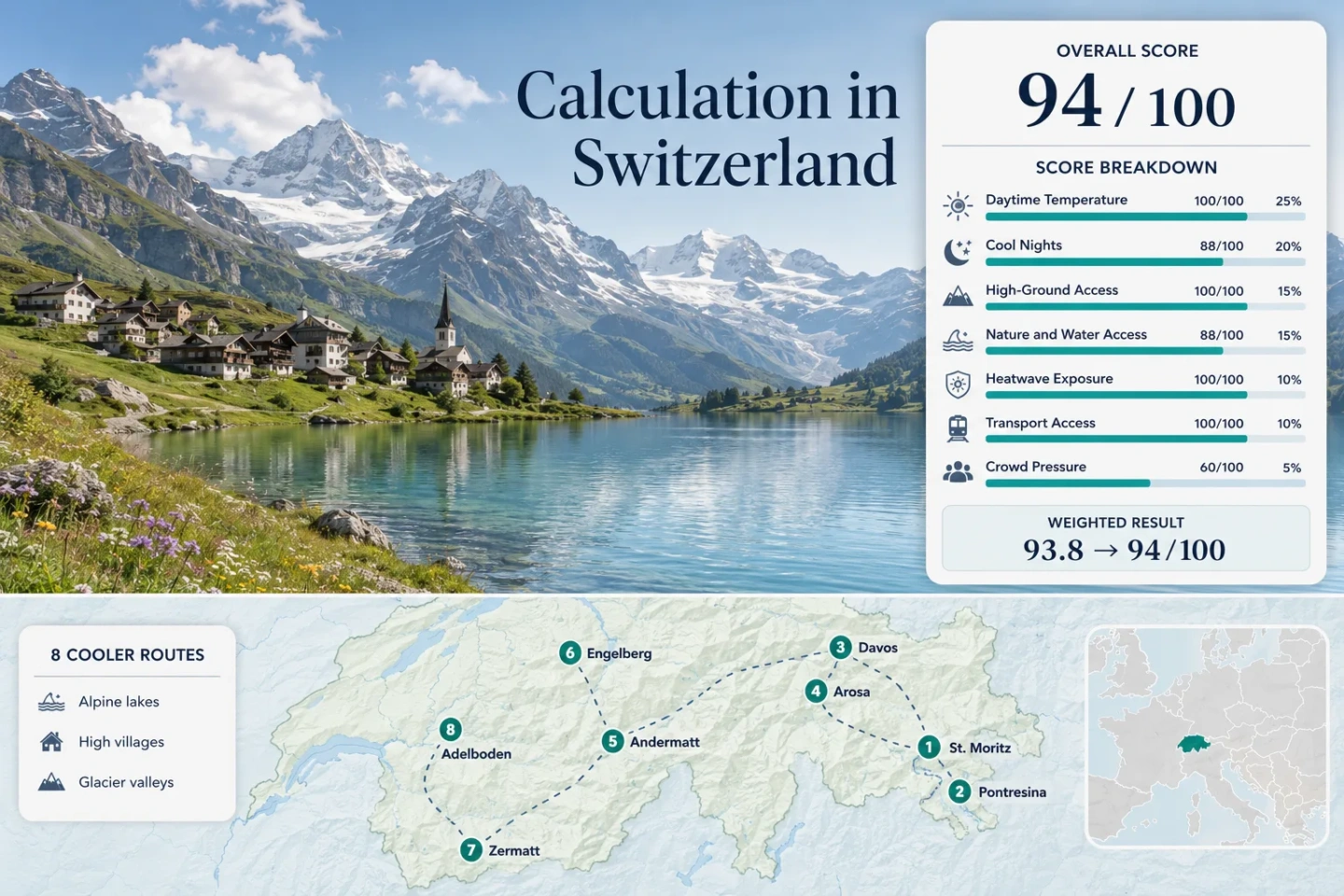
The same eight destinations are used in the marker map, score calculation, route profiles and comparison table.
Half of the selected village bases sit above this level; every route provides regular access to substantially higher ground.
The route-level July–August planning value is about 17.7°C for the average daily maximum.
Every base can be reached by train, scheduled bus or a simple rail-and-cable-car connection without a private vehicle.
Village access is dependable, but passes, gondolas and high-altitude excursions remain sensitive to seasonal schedules and weather.
High Villages from the Engadin to the Bernese Oberland
The route set spans the high lake basins of Graubünden, the glacier-facing villages of Valais, the Gotthard corridor and the wetter northern Alpine valleys. Marker positions represent planning centres rather than exact trailheads, legal parking areas or viewpoints.
This marker map is built for planning orientation. Marker positions use approximate public location centres where exact viewpoints, trailheads or transport platforms are not specified. Use the named Google Maps links and official operating information before travelling.
Switzerland Alpine Coolcation Suitability Score
This transparent editorial suitability index uses disclosed climate, high-ground, water-and-forest access, transport and peak-pressure factors. It is not an official climate classification, a comfort guarantee or a weather forecast.
Weighted total: 100×0.25 + 88×0.20 + 100×0.15 + 88×0.15 + 100×0.10 + 100×0.10 + 60×0.05 = 93.8 → 94/100
Method: Route count does not add bonus points. Each route carries equal weight, and route-level values are combined with the median before the seven fixed factor weights are applied.
Alpine Lakes, Glacier Valleys and High-Rail Bases
The strongest choices are not interchangeable. Upper Engadin bases emphasize cool nights and lake access, Valais routes provide high glacier railways with heavier booking pressure, while Engelberg and Adelboden trade slightly warmer village temperatures for rapid access to high plateaus.
St. Moritz and the Engadin Lakes
Elevation does most of the cooling work: St. Moritz sits at about 1,822 m, while the score uses a July–August daytime planning normal near 19.5°C and a night value near 7.0°C. Lake St. Moritz, Lej da Staz, Lake Champfèr, Silvaplana and Sils create several low-effort waterside alternatives when higher ridges become stormy.
The railway station meets the lake edge, and Engadin buses connect other lake settlements. July event dates and premium accommodation demand can make advance booking more important than the climate itself.
Pontresina and Morteratsch Glacier
Pontresina’s lodging base is approximately 1,805 m, with planning normals near 19.2°C by day and 7.1°C at night. The Rhaetian Railway continues directly to Morteratsch station, removing the usual parking problem from a glacier-valley day.
The official Morteratsch glacier route is roughly 2.9 km, while the nearby camping area sits at about 1,860 m in larch and Swiss stone pine woodland. The main comfort advantage is the ability to move between village shade, rail-served valley floor and much higher Bernina terrain without a long road transfer.
Davos and Lake Davos
At approximately 1,560 m, Davos has more urban-scale services than most high villages while retaining July–August planning values near 18.9°C by day and 8.6°C at night. Lake Davos adds swimming and flat shoreline access, and the local guest system supports public transport around the valley.
Arosa and Obersee
The coolest daytime value in the route set belongs to Arosa, with a July–August planning normal near 17.7°C. The village occupies a high basin around 1,775 m, Obersee is beside the railway terminus, and wooded slopes begin directly around the built area.
Direct Rhaetian Railway service from Chur makes Arosa unusually practical for a high settlement at the end of a mountain valley. Nights near 8.1°C support strong room cooling, though the winding rail journey is slower than its map distance suggests.
Andermatt and Oberalp Pass
Andermatt sits at approximately 1,444 m with July–August planning values near 18.2°C by day and 8.8°C at night. Its defining advantage is not village elevation alone: the Matterhorn Gotthard Railway climbs directly to the 2,046 m Oberalp Pass, connecting a lodging base with high ground without a car.
The 2026 mountain-rail operating window is narrower than the main railway timetable, and Alpine road openings remain weather-dependent outside midsummer. Main caution: Warm föhn periods can reduce the expected cooling advantage in the Ursern valley.
Engelberg, Trübsee and Titlis
Engelberg is the lowest base in the portfolio at roughly 1,013 m, reflected in the warmest route-level planning normal: about 20.3°C by day and 10.3°C at night. The compensation is unusually rapid vertical access. The Titlis system reaches 3,020 m in about thirty minutes, with Trübsee providing a lake stop partway up.
This is a temperature-switch route rather than a uniformly cold village stay. A warm afternoon at the base can be exchanged for high-elevation air without relocating accommodation, while the Zentralbahn provides direct rail access from central Switzerland.
Zermatt and Gornergrat
Zermatt combines a 1,608 m car-free village with a rack railway reaching Gornergrat at 3,089 m. The score uses July–August planning normals near 19.8°C by day and 8.3°C at night, placing the village within the cool range while preserving extensive accommodation and dining infrastructure.
Private vehicles stop at Täsch, making the arrival sequence predictable but mandatory. The car-free centre reduces traffic exposure, while Gornergrat and other lifts provide several altitude bands for changing weather.
Adelboden and Engstligenalp
Adelboden’s village base lies above 1,300 m, with July–August planning values near 19.6°C by day and 9.5°C at night. Scheduled buses connect the village with the rail network at Frutigen, while the Engstligenalp cable car reaches a high plateau that is otherwise accessible only on foot.
The published 2026 summer cable-car season runs from June 13 to October 18, with longer evening operation on selected July and August days. That creates a broader high-ground window than many seasonal Alpine lifts, but daily return times still shape hiking plans.
Engadin Nights and Valais Glacier Railways Solve Different Heat Problems
Upper Engadin Prioritizes Overnight Relief
St. Moritz and Pontresina combine high lodging elevations with route-level minimum-temperature normals near 7°C. This favors passive night cooling and early starts without requiring a morning cable-car journey. The lake basin also provides lower-commitment options when the Bernina ridges develop afternoon cloud.
Zermatt Prioritizes Vertical Range
Zermatt’s village is slightly warmer at night than the Upper Engadin bases, but Gornergrat reaches more than 3,000 m by rail. The route works for travellers who accept higher booking pressure in exchange for multiple altitude bands and a car-free transport system.
Engelberg Trades Dryness for Fast Glacier Access
Engelberg has the warmest village normal and a wetter northern-Alpine setting, yet the Titlis system changes elevation faster than any other route in the portfolio. Its value rises on stable mornings and falls when cloud, wind or excursion demand disrupts the high cable cars.
Rail Valleys and Cable-Car Plateaus Change the Car-Free Equation
A car-free label does not mean identical logistics. The selected routes divide into three transport structures, each with a different failure point during busy or unstable summer days.
Rail at the Lodging Base
St. Moritz, Pontresina, Davos, Arosa, Andermatt, Engelberg and Zermatt place scheduled rail at or close to the accommodation centre. Missed mountain transport may limit a high excursion, but it does not normally isolate the village.
Rail Continuing into High Terrain
Morteratsch, Oberalp Pass and Gornergrat are unusual because the railway continues beyond the lodging base into the cooling landscape itself. This reduces dependence on parking and provides a defined return timetable during changing weather.
Bus and Cable-Car Chains
Adelboden requires a train-to-bus arrival, followed by local transport for Engstligenalp. The system remains practical without a car, but each transfer adds a timetable boundary. Early and late-season plans depend more heavily on the published cable-car window.
Oberalp, Titlis and Engstligenalp Depend on Different Summer Windows
Mid-June to Late June
Engstligenalp begins its published 2026 summer operation on June 13, while several Andermatt mountain facilities begin later in June. Snowmelt, trail closures and reduced weekday operation matter more than average temperature during this period.
July to August
The widest transport network and the strongest hiking access coincide with the target score window. This is also the period with the greatest excursion pressure in Zermatt, Engelberg and St. Moritz and the highest thunderstorm frequency across Switzerland.
September to Mid-October
Cooler nights and lower demand can improve comfort, but operating hours shorten and individual mountain systems close on different dates. Engstligenalp publishes operation to October 18, while Alpine pass roads remain conditional on weather and early snowfall.
Eight Swiss Bases by Heat, Access and Operating Constraint
The comparison keeps the complete route set aligned with the map and score. Temperature values are historical planning normals, not trip-date forecasts.
| Route | Base Elevation | July–August Day / Night | Car-Light Access | Primary Cooling Asset | Main Constraint |
|---|---|---|---|---|---|
| St. Moritz and the Engadin Lakes | About 1,822 m | 19.5°C / 7.0°C | Direct rail and local bus | High lake basin and cool nights | Events and premium lodging demand |
| Pontresina and Morteratsch Glacier | About 1,805 m | 19.2°C / 7.1°C | Direct rail to village and glacier valley | Glacier-facing valley and larch forest | Rapid high-mountain weather changes |
| Davos and Lake Davos | About 1,560 m | 18.9°C / 8.6°C | Direct regional rail | Lake access with full town services | Frequent summer precipitation days |
| Arosa and Obersee | About 1,775 m | 17.7°C / 8.1°C | Direct mountain railway from Chur | Lowest daytime normal in the set | Slow valley railway and limited through-connections |
| Andermatt and Oberalp Pass | About 1,444 m | 18.2°C / 8.8°C | Direct rail to village and pass | Scheduled access to 2,046 m | Föhn warmth and seasonal mountain operations |
| Engelberg, Trübsee and Titlis | About 1,013 m | 20.3°C / 10.3°C | Direct rail plus cable car | Rapid ascent from village to 3,020 m | Excursion crowds, cloud and wind |
| Zermatt and Gornergrat | About 1,608 m | 19.8°C / 8.3°C | Car-free rail base and rack railway | Multiple glacier-facing altitude bands | High lodging and mountain-rail pressure |
| Adelboden and Engstligenalp | About 1,350 m | 19.6°C / 9.5°C | Train, scheduled bus and cable car | High plateau above a service village | Transfer chain and cable-car return times |