Armenia in Summer: High Plateaus, Lake Towns and Mountain Monasteries
Armenia’s summer heat changes sharply with elevation. Yerevan and the Ararat plain can be hot in July and August, while lake towns near 1,900 metres, forested resort bases, the Ashotsk plateau and high monastery routes retain cooler nights and shorter periods of intense afternoon heat. The strongest itinerary combines Lake Sevan, Dilijan’s forest belt, Jermuk’s 2,000-metre setting and the far-north Lake Arpi plateau, while treating Goris and Gyumri as culturally rich highland bases rather than guaranteed cold-weather retreats.
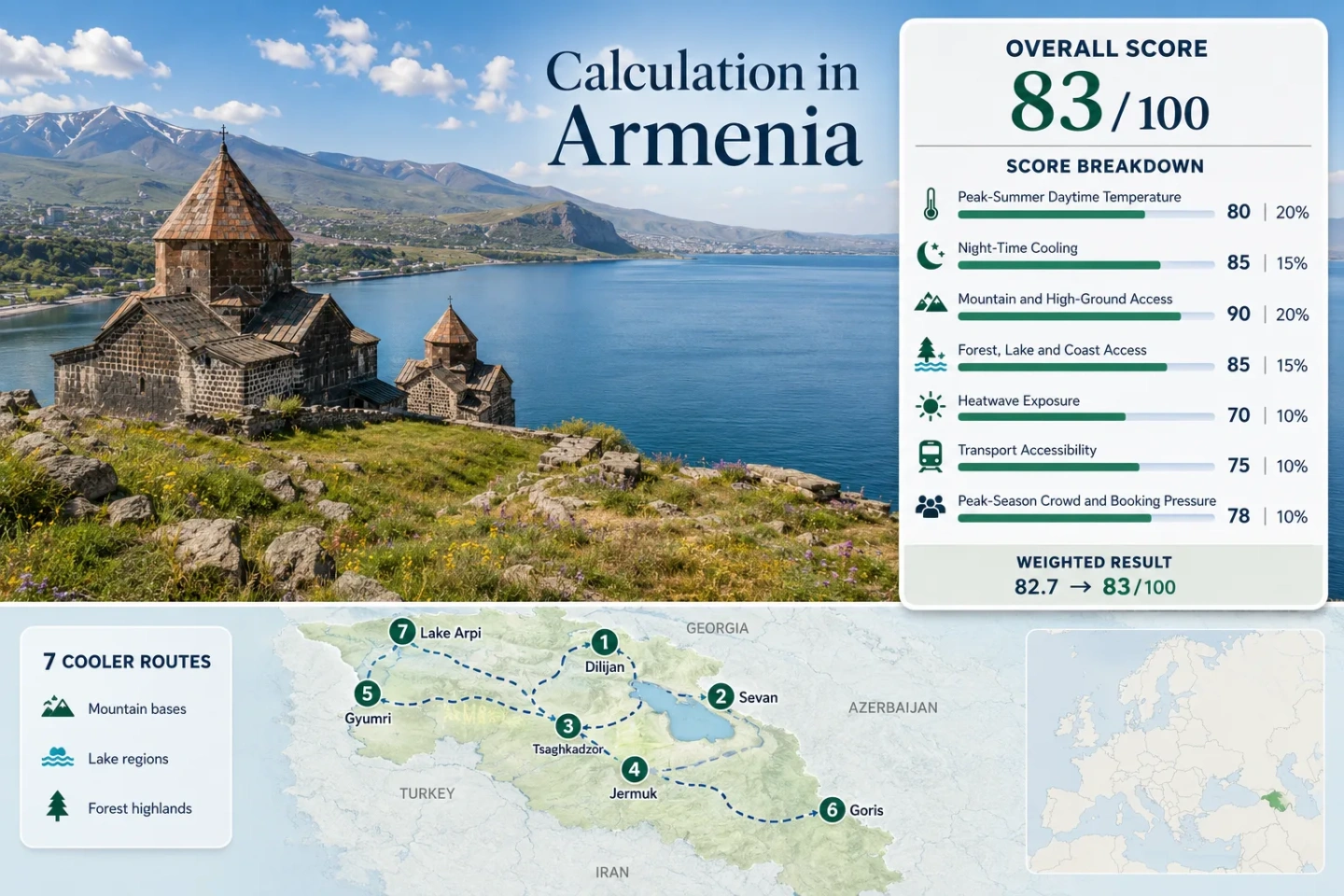
The score uses the same seven places shown on the map, in the route portfolio and in the comparison matrix.
Goris forms the lower edge; Lake Arpi sits on the Ashotsk plateau above 2,000 metres.
The July–August route-centre proxy is about 23°C by day, with nights near 9°C.
Rail and regular road transport make these the easiest cooler bases to combine without renting a car.
Sevan has broader visitor services and swimming; Arpi is cooler, quieter and much more vehicle-dependent.
The coolest southern and far-northern routes require longer road transfers than Tsaghkadzor or Sevan.
Lake Basins, Forest Towns and Monastery Routes Across Armenia
The marker set follows seven summer bases rather than every cool place in the country. It deliberately spans the Sevan basin, Tavush forests, Kotayk resort belt, Vayots Dzor highlands, Shirak plateau, Syunik uplands and the remote Lake Arpi edge.
Markers show selected cooler-route regions and planning centres, not guaranteed legal parking, trailheads or exact viewpoints. Lake Arpi is pinned near the lake centre, while its climate proxy uses Amasia as the practical settlement reference. Use each route card for Google Maps links and access notes before travelling.
Armenia Highland and Lake Cooler Escape Suitability Score
This transparent editorial suitability index uses disclosed climate, landscape, access and pressure factors for the seven mapped routes. It is not an official climate classification or a weather forecast.
Weighted total: 70×0.25 + 100×0.20 + 100×0.15 + 75×0.15 + 80×0.10 + 80×0.10 + 60×0.05 = 82.8 → 83/100
Method: Route count does not add bonus points. Each factor first combines the seven route values with the median, then applies the fixed site-wide weight.
High Plateaus, Lake Towns and Monastery Bases
The seven bases do not deliver the same kind of relief. Some reduce daytime heat through altitude and water, others mainly improve sleeping temperatures, and several exchange lower heat for longer transfers or limited local transport.
Dilijan and Haghartsin
Dilijan sits near 1,500 metres inside Armenia’s most continuous forested summer setting. The route-centre proxy is about 27°C by day and 13°C at night in July–August, so it is not the coldest option, but tree cover, shaded walks and nearby lakes make warm afternoons easier to manage than exposed plateau towns.
Haghartsin Monastery is reached by a forest road roughly 13 kilometres from town; Goshavank and Gosh Lake can form a second day. Intercity transport reaches Dilijan, but monastery and lake segments usually need a taxi, tour or car.
Tsaghkadzor and Kecharis
Tsaghkadzor is the fastest mountain reset from Yerevan: roughly 60 kilometres from the capital, with a resort base near 1,840 metres. The summer proxy is around 25.5°C / 12°C, producing reliable night cooling without the four-hour road commitment of Syunik.
Kecharis Monastery is inside the resort town, so culture does not require a separate remote-road day. The ropeway can shift the day higher above the tree line, but wind, maintenance and operating decisions should be checked locally before relying on lift access.
The trade-off is resort concentration: event weekends and large hotel occupancy can make the centre feel busier than the forest trails suggest.
Jermuk and Gndevank
Jermuk is the clearest low-heat base in the set. At roughly 2,080 metres, its route-centre proxy is about 23°C by day and 9°C at night. Forest, the Arpa gorge, mineral-water walks and Kechut reservoir provide several alternatives when exposed trails become sunny.
The cooling strength is real, but so is the transfer cost. Yerevan is roughly three hours away by road, and local flexibility improves sharply with a car or arranged driver.
Gyumri and Marmashen
Gyumri offers a high-plateau city rather than a resort enclosure. The base is near 1,550 metres; the July–August proxy is about 27°C by day and 12°C at night. Afternoon temperatures can still be warm, but dry air, evening cooling and a substantial urban centre make it practical for longer stays.
Transport profile: Direct rail and road links from Yerevan give Gyumri the strongest car-light access in the portfolio. Marmashen Monastery lies outside the centre near the Akhuryan River, so one short taxi or driver segment still improves the cultural route.
Goris and Tatev
Goris sits near 1,370 metres and records a route proxy around 25.5°C / 13°C. The real advantage is not extreme altitude at the hotel door; it is access to the higher Syunik landscape, Vorotan Gorge and Tatev’s exposed plateau without sleeping in Armenia’s hottest southern valleys.
Wings of Tatev links Halidzor to the monastery and runs on a published seasonal calendar; May–September service is generally Tuesday–Sunday and holidays, with weather and technical interruptions still possible. Arriving early reduces queue and parking pressure.
Lake Arpi and Amasia
Lake Arpi occupies the Ashotsk plateau at about 2,025 metres. The Amasia settlement proxy is approximately 24°C by day and 10.5°C at night, and the lake shore itself can be cooler and windier. This is the route with the lowest visitor pressure and the weakest public-transport flexibility.
The landscape is open rather than forest-dense: wetlands, grassland, streams and broad sky replace Dilijan’s shade. The official tourism information advises carrying a passport because the park lies close to Armenia’s northern border.
Seven Routes Compared by Heat, Access and Cultural Reach
The matrix uses all seven scored routes. “Car-light” describes the base, not every monastery, lakeshore or trail inside the route.
| Route | Base or route elevation | July–August day / night proxy | Car-light strength | Main heritage link | Primary trade-off |
|---|---|---|---|---|---|
| Dilijan and Haghartsin | About 1,500 m | 27°C / 13°C | Moderate | Haghartsin and Goshavank | Forest shade is strong; monastery access needs local transport. |
| Sevan and Sevanavank | About 1,900 m | 25.5°C / 13°C | Strong | Sevanavank and Hayravank | Wind and water access improve comfort; weekend pressure is concentrated. |
| Tsaghkadzor and Kecharis | About 1,840 m | 25.5°C / 12°C | Strong | Kecharis Monastery | Fast from Yerevan; resort events can reduce quietness. |
| Jermuk and Gndevank | About 2,080 m | 23°C / 9°C | Moderate | Gndevank Monastery | Lowest daytime heat; longest transfer among the northern alternatives. |
| Gyumri and Marmashen | About 1,550 m | 27°C / 12°C | Very strong | Marmashen Monastery | Excellent city logistics; afternoons are warmer than Jermuk or Arpi. |
| Goris and Tatev | About 1,370 m | 25.5°C / 13°C | Moderate | Tatev Monastery | Exceptional highland culture; road time is substantial. |
| Lake Arpi and Amasia | 1,850–2,025 m | 24°C / 10.5°C | Limited | Shirak plateau heritage en route | Cold nights and low crowds; sparse services and remote access. |
Sevan Basin and Ashotsk Plateau Solve Different Summer Problems
Sevan: Water Access With Visitor Infrastructure
Sevan combines a high-altitude lake, beaches, food services, monasteries and seasonal public transport. It is the more practical choice for travellers who want swimming, boat access and a one- or two-night stay. Its weak point is concentration: the peninsula and northern beaches become busy at the same times.
Lake Arpi: Colder Nights With Sparse Services
Arpi sits higher and farther north, with open wetland and plateau wind rather than beach infrastructure. It suits birding, quiet road travel and cold-night priorities. Comfort depends on preparation: food, fuel, local road conditions and border-area identification matter more than at Sevan.
Choose by Activity, Not by the Word “Lake”
Sevan is the stronger water-activity base; Arpi is the stronger low-pressure plateau retreat. A traveller seeking a swim and cafés may find Arpi under-serviced, while a traveller seeking silence may find Sevan’s central shore too active in peak summer.
Forest Roads, Stair Climbs and Cable Cars Shape Monastery Days
Haghartsin and Gndevank Reward a Driver-Based Day
Haghartsin lies about 13 kilometres from Dilijan through forest, while Gndevank sits beyond Jermuk near Kechut reservoir and the Arpa corridor. Both routes keep travellers near cooler landscapes, but neither is efficiently covered by walking from the town centre.
Kecharis and Sevanavank Reduce Transfer Friction
Kecharis is integrated into Tsaghkadzor, and Sevanavank is attached to the main peninsula visitor zone. These are the easiest monastery stops to pair with a short stay, though Sevanavank’s exposed steps can feel hot under midday sun despite the lake elevation.
Tatev Depends on a Published Operating Window
The 5.7-kilometre Wings of Tatev tramway changes the access problem from a steep gorge road to a timed attraction. The official calendar lists May–September service Tuesday–Sunday and holidays, generally 10:00–19:00, with the last flight before closing. Weather and technical interruptions still require a same-day check.
Marmashen Fits a Rail-Based Gyumri Stay
Gyumri can be reached by train, then Marmashen can be covered with a short local road segment. This split is useful for travellers who want highland evenings and architecture without committing to a full self-drive itinerary.
From Yerevan, Cooling Strength Rises Faster Than Transport Simplicity
40–90 Minutes: Tsaghkadzor and Sevan
These routes are realistic for a spontaneous overnight or day trip. They provide strong night cooling and immediate high ground, but weekend activity can be concentrated and midday sun remains strong.
Two to Three Hours: Dilijan, Gyumri and Jermuk
Dilijan and Gyumri balance services with highland nights. Jermuk pushes farther and higher, producing the lowest daytime proxy in the set but asking for a longer road commitment.
Four Hours or Regional Staging: Goris and Lake Arpi
Goris works after a deliberate southbound travel day; Lake Arpi works more naturally from Gyumri or another Shirak base. Both become inefficient when forced into a same-day return from Yerevan.
Late June to Early September: Access, Water and Night Cooling
Late June
Long daylight and greener slopes favour Dilijan, Tsaghkadzor and the Sevan basin. Higher plateau roads may still carry storm or snowmelt effects, so Lake Arpi and remote mountain segments need local condition checks.
July to Mid-August
This is the strongest swimming and high-road access window, but also the period with the greatest Sevan beach pressure and the hottest afternoons in Gyumri, Dilijan and Goris. Jermuk and Lake Arpi preserve the clearest daytime advantage.
Late August to Early September
Nights remain cool while crowd pressure can ease outside event weekends. Lake water gradually becomes less inviting, but monastery walks and city bases often become more balanced for travellers who prioritise walking over swimming.