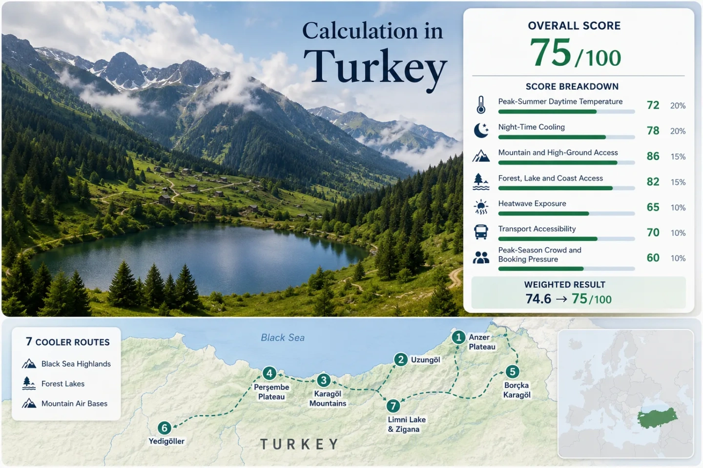
Turkey Coolcation Routes: Black Sea Highlands, Forest Lakes and Mountain Air
Turkey’s cooler summer alternatives are concentrated above the humid Black Sea coast, where yayla settlements, glacial mountain basins and forest lakes trade lowland heat for elevation, cloud cover and stronger night-time cooling. The clearest July–August temperature relief comes from high bases such as Anzer, Perşembe Plateau and Limni Lake, while Uzungöl, Borçka Karagöl and Yedigöller add water and forest access with different crowd, rain and road conditions.
The route set covers the eastern Black Sea highlands, central yaylas, forest lakes and the western Black Sea interior.
Ballıköy provides the strongest accommodation-level elevation in the selected portfolio.
Bolu’s July–August representative normal averages about 12.6°C at night, substantially cooler than the coastal eastern stations.
A 2,025 m lake-and-forest base combines high-ground access with comparatively dry summer conditions.
The strongest relief occurs when coastal access is followed by a rapid climb toward bases between roughly 1,000 and 2,100 metres.
Eastern routes can remain wet and visibility can change quickly even when temperatures are moderate.
Black Sea Yaylas, Mountain Lakes and Forest Bases
The selected locations form three distinct planning zones: the Rize–Trabzon–Artvin highlands, the Ordu–Giresun–Gümüşhane mountain belt and the forested western Black Sea interior around Bolu.
This marker map is built for planning orientation. Marker positions use approximate public location centres where exact viewpoints, trailheads, legal parking areas or pull-offs are not specified. Markers show selected cooler-route regions, not guaranteed legal parking or exact navigation points. Use each route card for Google Maps links and access notes before travelling.
Turkey Black Sea and High-Ground Suitability Score
This transparent editorial suitability index measures the seven displayed routes rather than Turkey as a whole. The result uses disclosed climate, landscape, access and pressure factors. It is not an official climate classification or a weather forecast.
Province-centre meteorological normals are used as consistent warm-side proxies where direct highland station tables are not publicly available. Large elevation differences mean plateau temperatures should not be interpreted as identical to the cited city stations.
Method: July and August average daily maximum temperatures were averaged for each representative provincial station. The median of the seven one-decimal route values was normalised using the fixed daytime-temperature scale.
Raw: Median 26.5°C. Interpolation between 25°C = 75 points and 27°C = 55 points produces 60 points.
Route values: Anzer (Ballıköy) Plateau 26.3°C; Uzungöl 26.4°C; Karagöl Mountains 26.5°C; Perşembe Plateau 28.1°C; Borçka Karagöl 26.2°C; Yedigöller National Park 27.8°C; Limni Lake and Zigana 28.7°C.
Station mapping: Rize station represents Anzer at approximately 90 km distance and about 2,100 m lower elevation; Trabzon represents Uzungöl at approximately 99 km and about 1,050 m lower elevation; Giresun represents Karagöl Mountains at approximately 70 km and more than 2,000 m lower than the upper basins; Ordu represents Perşembe Plateau at roughly 110 km and about 1,500 m lower elevation; Artvin represents Borçka Karagöl at roughly 35–60 km with a substantial local elevation difference; Bolu represents Yedigöller at 42 km with a smaller elevation difference; Gümüşhane represents Limni Lake at 40 km and roughly 875 m lower elevation. Station codes are not published on the cited public tables.
Period: Long-period official station statistics vary by province: Rize and Trabzon 1927–2025, Giresun 1929–2025, Artvin 1949–2025, Bolu 1929–2025 and Gümüşhane 1961–2025.
Sources: Turkish State Meteorological Service — Rize; Trabzon; Giresun; Ordu; Artvin; Bolu; Gümüşhane.
Method: July and August average daily minimum temperatures were averaged for each representative station. The route median was normalised against the fixed night-cooling thresholds.
Raw: Median 19.9°C. Interpolation between 18°C = 85 points and 20°C = 60 points produces 61 points after rounding.
Route values: Anzer (Ballıköy) Plateau 19.9°C; Uzungöl 20.3°C; Karagöl Mountains 20.2°C; Perşembe Plateau 20.8°C; Borçka Karagöl 17.2°C; Yedigöller National Park 12.6°C; Limni Lake and Zigana 14.0°C.
Interpretation: These are representative station values, not direct plateau-night measurements. The high eastern routes commonly sit 1,000–2,100 m above their coastal proxies, so the score avoids claiming that highland accommodation shares the warmer coastal minimum.
Period: The same official long-period station tables used for the daytime factor.
Sources: MGM Rize climate statistics; MGM Trabzon climate statistics; MGM Giresun climate statistics; MGM Ordu climate statistics; MGM Artvin climate statistics; MGM Bolu climate statistics; MGM Gümüşhane climate statistics.
Method: Fixed high-ground rubric based on accommodation elevation or regular access to meaningful higher terrain within approximately 60 minutes.
Route scores: Anzer (Ballıköy) Plateau 100 — accommodation base at 2,105 m; Uzungöl 100 — high-valley base around 1,100 m with surrounding mountain access; Karagöl Mountains 100 — direct access to a glacial mountain system rising above 3,000 m; Perşembe Plateau 100 — base around 1,500 m; Borçka Karagöl 100 — high forest-lake basin and surrounding mountain roads; Yedigöller National Park 80 — elevated forest interior with lower relief than the yayla routes; Limni Lake and Zigana 100 — lake base at 2,025 m.
Raw: Sorted scores 80, 100, 100, 100, 100, 100, 100. Median 100.
Period: Access and published destination descriptions reviewed July 15, 2026.
Sources: Turkey Culture Portal — Anzer Plateau; Trabzon Provincial Directorate — Uzungöl; Karagöl Mountains; Perşembe Plateau; Borçka Karagöl; Yedigöller National Park; Limni Lake Nature Park.
Method: Fixed physical-access rubric measuring whether broad forest, a significant lake or river system, or the coast is reachable within 30 minutes.
Route scores: Anzer (Ballıköy) Plateau 75 — mountain streams and highland vegetation but no large lake or coast at the base; Uzungöl 100 — lake, forest and river-valley access; Karagöl Mountains 100 — glacial lakes and mountain vegetation; Perşembe Plateau 75 — river meanders and highland grassland; Borçka Karagöl 100 — forest and lake in the same destination; Yedigöller National Park 100 — seven-lake forest system; Limni Lake and Zigana 100 — lake and forest ecosystems at the same high base.
Raw: Sorted scores 75, 75, 100, 100, 100, 100, 100. Median 100.
Period: Physical-access descriptions reviewed July 15, 2026.
Sources: Anzer destination record; Uzungöl destination record; Karagöl mountain lakes; Perşembe Plateau; Borçka Karagöl; Yedigöller National Park; Limni Lake Nature Park.
Method: Official threshold-frequency fallback. Turkey’s official heat-zone mapping uses daily maximum temperature records from 250 stations for 1975–2010 and classifies areas by annual days at or above 30°C. Published zone ranges were converted to conservative class-midpoint July–August exposure proxies; they are not presented as exact observed 2016–2025 daily counts.
Route values: Anzer (Ballıköy) Plateau 0.8%; Uzungöl 6.5%; Karagöl Mountains 0.8%; Perşembe Plateau 0.8%; Borçka Karagöl 0.8%; Yedigöller National Park 6.5%; Limni Lake and Zigana 0.8%.
Raw: Median proxy 0.8% of July–August days. The fixed scale awards 100 points for exposure of 0–1%.
Coverage: A daily valid-days test is not applicable because the fallback is a published official threshold-zone product rather than a newly extracted daily series.
Period: Daily maximum records used by the official study cover 1975–2010.
Source: Turkish State Meteorological Service — Mapping Plant Hardiness and Heat Zones at Turkey Scale.
Method: Fixed accessibility rubric based on practical public-transport reach, final-road complexity and car dependence at the destination.
Route scores: Anzer (Ballıköy) Plateau 40 — long mountain approach and locally car-dependent movement; Uzungöl 80 — established road destination with regular regional transport, though local flexibility improves with a car; Karagöl Mountains 40 — remote mountain access and trail-dependent final movement; Perşembe Plateau 60 — road access from Aybastı but limited car-free flexibility; Borçka Karagöl 40 — 27 km mountain-road approach from Borçka; Yedigöller National Park 40 — 42 km park-road approach from Bolu and weak internal public transport; Limni Lake and Zigana 60 — road access near the Trabzon–Gümüşhane corridor but a vehicle remains useful for the final kilometres.
Raw: Sorted scores 40, 40, 40, 40, 60, 60, 80. Median 40.
Period: Published access descriptions reviewed July 15, 2026.
Sources: Anzer access record; Uzungöl distance record; Karagöl access record; Perşembe road record; Borçka Karagöl access record; Yedigöller road record; Limni Lake distance record.
Method: Official qualitative-indicator fallback. A consistent three-year route-level occupancy series was not publicly available for all seven mountain and park locations. Scores therefore use the fixed categorical rubric with published accommodation statistics context, destination capacity, road concentration, event timing and route prominence.
Route scores: Anzer (Ballıköy) Plateau 60 — limited accommodation but lower mass demand than Uzungöl; Uzungöl 20 — concentrated high-season demand in a narrow lake valley; Karagöl Mountains 80 — dispersed, remote and hiking-oriented; Perşembe Plateau 40 — additional July pressure around the annual festival; Borçka Karagöl 40 — limited road and lakeside capacity; Yedigöller National Park 40 — concentrated park-road and weekend pressure; Limni Lake and Zigana 60 — moderate seasonal demand with wider regional alternatives.
Raw: Sorted scores 20, 40, 40, 40, 60, 60, 80. Median 40.
Period: Latest available accommodation-statistics framework and destination access information reviewed July 15, 2026.
Sources: Ministry of Culture and Tourism — Tourism Statistics; Accommodation statistics metadata; Perşembe Plateau festival and access record; Yedigöller park record; Uzungöl destination record.
Comparability quality C: The factor structure and normalisation are fully comparable, but direct highland climate stations, a uniform recent daily heatwave series and consistent route-level occupancy data were not available across the entire portfolio.
Highland Villages, Glacial Basins and Forest-Lake Roads
The seven locations do not offer the same type of relief. Eastern yaylas emphasise elevation and cloudier mountain air, Gümüşhane adds drier high-ground conditions, and Bolu provides stronger night cooling without requiring a Black Sea coastal approach.
Anzer (Ballıköy) Plateau
A 2,105 m accommodation base above the İkizdere valleys
Anzer places the overnight base directly inside the highland zone rather than requiring a daily climb from the coast. The official destination record identifies Ballıköy at 2,105 m, making it the clearest altitude-first choice in the route set.
Rize’s coastal representative normal averages 26.3°C by day and 19.9°C at night in July–August, with about 13.9 days of rain per month. The large elevation difference means the plateau can be substantially cooler, but fog, rain and rapid cloud changes remain central planning factors.
Uzungöl
Lake access, forested slopes and an established high-valley base
Uzungöl lies approximately 99 km from Trabzon and 19 km from Çaykara. Its accommodation supply and regional transport links make it the most practical car-light entry into the selected highland network.
The Trabzon representative normal averages 26.4°C by day, 20.3°C at night and roughly eight rainy days per month in July–August. Actual conditions around the elevated lake can be cooler than the coast, especially at night and during cloudy periods.
Karagöl Mountains
Glacial lakes below a 3,107 m Black Sea mountain system
The Karagöl Mountains rise to 3,107 m and contain several glacial lakes. The official destination description places the mountain area around 70 km from Giresun, creating a remote hiking-oriented route rather than a conventional resort base.
July–August average maximum at Giresun’s official representative station.
Coastal proxy; upper mountain camps and yaylas should not be assumed to share this minimum.
Approximate monthly July–August mean at the representative station.
The value here is remoteness and vertical range rather than easy logistics. Trail conditions, cloud development and the final road surface require more attention than at Uzungöl.
Perşembe Plateau
A 1,500 m yayla with river meanders above Aybastı
Perşembe Plateau provides a high overnight environment without the concentrated lake-valley form of Uzungöl. Ordu’s representative July–August averages are warmer at 28.1°C by day and 20.8°C at night, but the approximately 1,500 m plateau base provides a major local elevation advantage.
Watch for: Accommodation and road pressure rise around the traditional July plateau festival, while fog can reduce visibility on the approach.
Borçka Karagöl
A forest lake reached by a 27 km mountain-road approach
Borçka Karagöl combines two cooling assets in one compact destination: a mountain lake and dense forest cover. The official destination record places it approximately 27 km from Borçka on the Borçka–Camili road.
Artvin’s representative July–August normal averages 26.2°C by day and 17.2°C at night, with about 8.2 rainy days per month. This is the strongest eastern route for travellers who value a cooler night proxy without committing to an exposed, treeless high plateau.
Yedigöller National Park
Seven forest lakes and the coolest representative nights in the portfolio
The official park description identifies a 42 km fully asphalt approach from Bolu and an alternative route of approximately 45 km. The recommended seasonal window extends from April through November.
Bolu’s representative July–August normal averages 27.8°C by day but only 12.6°C at night. That wide day–night contrast gives Yedigöller a different comfort pattern from the humid eastern coast: warmer afternoons can be followed by distinctly cooler evenings.
Weekend road and parking pressure can be more important than accommodation pressure inside the forest-lake system.
Limni Lake and Zigana
A 2,025 m forest-lake base near the Zigana crossing
Limni Lake Nature Park sits at approximately 2,025 m, around 5.5 km from Zigana village and nearby ski facilities, 16 km from Torul, 40 km from Gümüşhane and about 60 km from Trabzon.
The second-highest stated overnight or recreation base in the route portfolio.
Gümüşhane representative July–August average minimum.
Substantially drier than the Rize, Giresun and Artvin representatives.
Limni is the strongest balance of high elevation, lake-and-forest access and a relatively dry inland climate signal. Afternoon sun can still feel strong at altitude, but the night-cooling profile is more favourable than the eastern coastal proxies.
Why Coastal Normals Understate the Yayla Temperature Drop
Rize, Trabzon, Giresun and Ordu meteorological tables provide consistent official comparisons, but their coastal or lower-elevation stations sit far below the selected yaylas. The score therefore treats them as conservative warm-side proxies rather than direct highland forecasts.
Rize and Trabzon Rise Quickly Above the Coast
Anzer reaches 2,105 m and Uzungöl sits near 1,100 m after approaches that begin near the Black Sea. A coastal maximum near 26°C does not describe the full vertical climate transition encountered on those roads.
Giresun and Ordu Add Distance as Well as Elevation
Karagöl Mountains and Perşembe Plateau lie well inland from their representative coastal stations. The cooler-air benefit is paired with longer access, less predictable visibility and fewer easy fallback services.
Zigana Trades Maritime Humidity for Inland Range
Limni Lake remains within the Black Sea mountain system but uses Gümüşhane’s drier inland climate signal. Its approximately 14°C night proxy and lower rainy-day frequency separate it from the wetter Rize and Giresun routes.
Which Route Matches the Cooling Priority?
The comparison keeps all seven mapped routes in the same decision frame. Climate values are representative station normals; access and pressure columns describe the destination itself.
| Route | Main Cooling Mechanism | Representative July–August Night | Access Pattern | Rain or Capacity Trade-Off | Works for |
|---|---|---|---|---|---|
| Anzer (Ballıköy) Plateau | 2,105 m overnight elevation | 19.9°C coastal proxy; plateau normally cooler | Long mountain-road approach; car useful | High rain frequency, fog and limited accommodation | Altitude-first stays and quiet highland nights |
| Uzungöl | High valley, lake and forest | 20.3°C coastal proxy | Strongest regional public-transport access | Heavy peak demand and concentrated traffic | Shorter car-light highland trips |
| Karagöl Mountains | Glacial basins and terrain above 3,000 m | 20.2°C coastal proxy; upper basins cooler | Remote road and trail combination | Cloud, wet ground and limited services | Hiking-focused mountain itineraries |
| Perşembe Plateau | 1,500 m yayla base | 20.8°C coastal proxy | 17 km road approach from Aybastı | Festival-period traffic and fog | Plateau scenery without an eastern Black Sea loop |
| Borçka Karagöl | Forest shade, lake water and mountain air | 17.2°C representative proxy | 27 km mountain-road approach | Limited lakeside capacity and wet-road conditions | Forest-lake stays with cooler eastern nights |
| Yedigöller National Park | Dense forest and strong day–night range | 12.6°C representative proxy | 42 km asphalt route from Bolu | Weekend road, parking and picnic pressure | Cool nights and shaded low-intensity walking |
| Limni Lake and Zigana | 2,025 m base with drier inland air | 14.0°C representative proxy | Road-linked to Torul, Gümüşhane and Trabzon | Exposed afternoon sun and final-road dependence | High elevation with a lower rainfall trade-off |
Fog, Festival Traffic and Forest Roads Change the Daily Plan
Use Morning Hours for the Long Highland Climbs
Anzer, Karagöl Mountains and Borçka Karagöl involve lengthy final approaches where afternoon cloud development can hide road edges and reduce the value of scenic stops. Earlier departures preserve more daylight for the return or overnight check-in.
Separate Perşembe’s Festival Period from Ordinary Weekdays
The traditional July gathering changes the plateau from a spacious highland base into a capacity-sensitive event destination. Accommodation, food services and the 17 km Aybastı approach should be assessed differently during festival dates.
Treat Yedigöller as a Road-Capacity Decision
The 42 km asphalt approach improves surface reliability, but weekend arrivals can still concentrate on the same forest roads and lake-side areas. A weekday overnight pattern protects the cool-evening advantage from daytime parking pressure.
Two Regional Loops Reduce Black Sea Backtracking
Trabzon, Rize and Artvin Loop
Uzungöl, Anzer and Borçka Karagöl form the strongest eastern sequence. Trabzon supplies the broadest arrival infrastructure, Anzer raises the overnight base above 2,000 m and Borçka adds a forest-lake environment with a cooler Artvin night proxy.
Planning rhythm: Keep at least one flexible weather day. Heavy rain or low cloud can affect one highland road while leaving a lower forest destination usable.
Ordu, Giresun and Zigana Loop
Perşembe Plateau, Karagöl Mountains and Limni Lake create a longer central mountain arc. Perşembe provides an accessible yayla base, Karagöl adds the largest vertical terrain and Limni supplies the driest representative summer signal.
Planning rhythm: Avoid combining all three as day trips from one city. Distances, mountain roads and hiking time make two or three overnight bases more realistic.