Azerbaijan Cooler Routes: Caucasus Villages, Forest Slopes and High Mountain Roads
Azerbaijan’s strongest summer heat alternatives sit well above the Caspian lowlands: stone villages above 2,000 metres, waterfall valleys in the Greater Caucasus, forested roads around Ismayilli and lake country beneath the Lesser Caucasus. The seven-route set concentrates on July–August daytime relief, cooler nights and practical access, while accounting for canyon roads, limited village transport, park controls and local booking pressure.
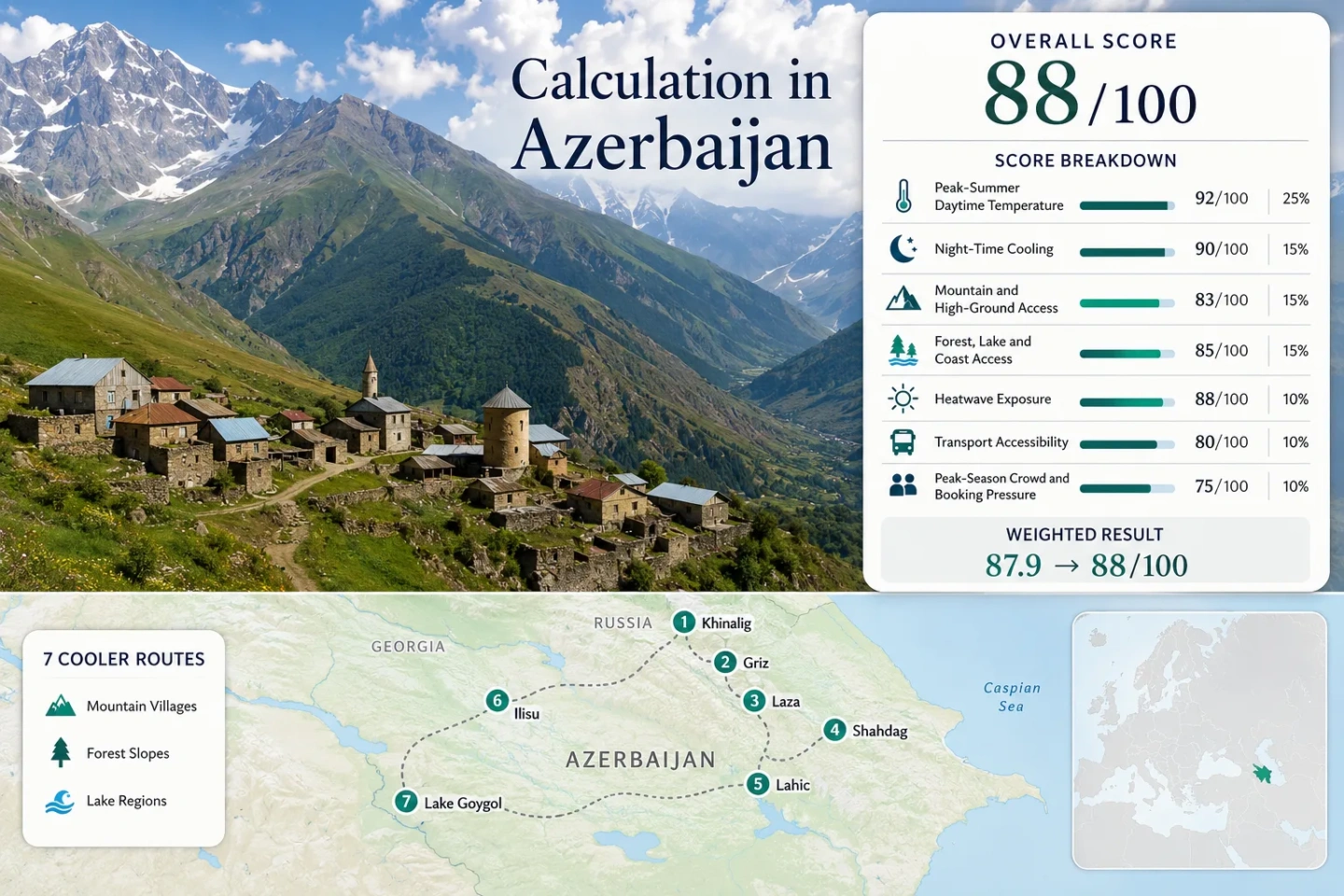
Four Greater Caucasus village zones, two forest-slope routes and one high lake corridor in the Lesser Caucasus.
The settlement stands at roughly 2,180–2,300 metres, with walking routes extending across the surrounding highland landscape.
July–August mean daily maximum from the disclosed ERA5-Land route-centre proxy calculation.
Its high lodging base produces the lowest daytime and night-time temperature proxy in the assessed set.
Rail reaches Ganja, Gakh and regional corridors, but most village, waterfall and park approaches still need a road transfer.
From the Quba High Road to the Goygol Forest Belt
The markers connect the high village cluster north of Quba and Qusar with Lahic’s canyon approach, Ilisu’s forest-and-waterfall corridor and Lake Goygol beneath Mount Kapaz.
Markers show selected cooler-route regions and planning centres, not guaranteed legal parking, trailheads or exact viewpoints. Mountain roads, park access points and local traffic arrangements should be checked before departure.
Azerbaijan Caucasus Cooler Escape Suitability Score
This transparent editorial suitability index uses disclosed climate, landscape, access and pressure factors. It is not an official climate classification or a weather forecast. The result represents the seven named routes rather than Azerbaijan as a whole.
Weighted total: 92×0.25 + 100×0.20 + 100×0.15 + 75×0.15 + 100×0.10 + 60×0.10 + 60×0.05 = 88.3 → 88/100
Method: Route count adds no bonus points. Each route carries equal weight inside a factor, route values are combined using the median and the seven fixed factor weights are then applied.
High Villages, Waterfall Valleys and Forested Lake Roads
The portfolio separates true high-altitude bases from lower forest routes that depend more on shade, water and night cooling. Access ranges from a full-service mountain resort to villages where a local driver, suitable vehicle or walking approach remains part of the route.
Khinalig and the Upper Qudyal Valley
Elevation drives the route: Khinalig’s settlement and nearby marked walking terrain occupy roughly the 2,150–2,300-metre band. The July–August proxy produces a 19.6°C mean daily maximum, an 8.4°C mean minimum and only one 30°C+ day across the assessed 620-day heatwave window.
The paved approach has made the village more reachable, but the final road remains exposed to fast cloud development, heavy rain, falling material and visibility changes. Accommodation capacity is limited compared with Quba or Shahdag.
Griz, Gurgur Waterfall and the Galakhudat Trail
Griz trades easy access for a high settlement base and a deeply cut mountain setting. Its route-centre proxy reaches a July–August maximum average of 20.8°C and minimum average of 9.6°C, while the nearby Gurgur Waterfall sits at about 2,190 metres.
The marked Griz–Galakhudat route reaches approximately 2,225 metres and includes major elevation change. Reaching the village or arranging the correct trail direction generally demands more preparation than the Khinalig or Shahdag roads.
Laza and the Qusar River Waterfall Valley
Laza sits at roughly 1,300 metres, with walking routes rising toward the 1,670-metre band and higher slopes. The climate proxy is milder than Azerbaijan’s lowland cities without producing Khinalig-level cold: 23.4°C by day and 12.9°C at night for the target window.
Waterfalls, the Qusar River gorge and scattered woodland add local relief, but the village can still receive strong midday sun. Laza works more naturally as a road-and-walk route than a car-free destination.
Shahdag’s 1,435–2,552-Metre Resort Band
The resort begins at about 1,435 metres and extends to roughly 2,552 metres through its developed lift and slope network. That altitude range makes it the most straightforward high-ground route for travellers who prefer hotel infrastructure, organized activities and a defined mountain base.
Climate proxy: 22.6°C mean daily maximum, 11.8°C mean minimum and four 30°C+ days in 620 assessed July–August days. The resort lies 29 km from Qusar, giving it a stronger road-access score than the remote village routes.
Lahic’s Canyon Road and Forested Ismayilli Slopes
Lahic is lower and warmer than the northern high-village cluster, but its approximate 1,200-metre base, surrounding forested slopes and cooler nights still separate it from Baku’s summer pattern. The route proxy gives 24.7°C daytime and 14.1°C night-time averages.
The village is commonly approached on a roughly three-hour road journey from Baku. The final canyon section is part of the route’s character and also its main weakness: weekend traffic, road works, intense rain or slope debris can affect timing.
Lahic is the warmer compromise in the set, useful when cultural streets, guesthouses and a shorter Baku approach matter more than obtaining the lowest temperature.
Ilisu, Gashgachay Forests and the Greater Caucasus Edge
Ilisu combines a mountain-village base with forest, fast water and access toward steeper Greater Caucasus terrain. The July–August proxy stands at 24.0°C by day and 13.3°C at night, with 13 of 620 assessed days reaching 30°C or more.
Rail service reaches Gakh on the Baku–Balakan corridor, but Ilisu still requires a road transfer. The waterfall can be approached by a steep walk of roughly an hour or by locally arranged transport over the rocky approach.
Lake Goygol Beneath Mount Kapaz
Lake Goygol lies at about 1,500 metres inside a protected Lesser Caucasus landscape, roughly 30 km south of Goygol city. Forest and lake influence operate together here, producing a different summer experience from the open alpine terrain around Khinalig and Shahdag.
Baku–Ganja rail service reduces the long-distance driving burden, but the station is only the regional gateway. A separate road journey and current national park access arrangement remain necessary.
Khinalig, Griz and Laza Do Not Share the Same Access Pattern
The northern cluster looks compact on a national map, yet each branch demands a different transport decision. Treating all three villages as interchangeable Quba day trips can create unrealistic driving and walking plans.
Khinalig Has the Clearest High-Village Road
Khinalig is 57 km from Guba and now has a defined mountain-road approach. It remains a long, exposed drive, but the village can function as a single overnight base without requiring a trail connection from another settlement.
Griz Requires a Local Transfer Decision
Griz provides similar high-altitude temperature benefits with less straightforward vehicle access. The Griz–Galakhudat walking corridor is a real route choice, not merely an optional stroll added after an easy bus arrival.
Laza and Shahdag Share a Valley but Serve Different Trips
Laza retains a village-and-waterfall rhythm, while Shahdag offers hotels, managed facilities and a broad altitude band. Combining them in one day is possible by road, but it reduces time available for walking and makes operating hours at the resort more important.
Ilisu’s Border Zone and Goygol’s Park Controls Change the Route
The Village Is Easier Than the Upper Valleys
Ilisu itself is a practical road destination from Gakh. The planning threshold changes beyond the village, where trails enter protected terrain and approach Azerbaijan’s international border zone. A casual waterfall visit and a multi-day mountain crossing should not be planned as the same access category.
Works for: Travellers using Gakh or Ilisu as a fixed base and selecting marked, locally confirmed walks.
Lake Goygol Is Not an Unrestricted Drive-Up Lake
Goygol National Park protects a high lake system and forest belt beneath Mount Kapaz. Vehicle access, parking, transfers and visitor movement can be controlled, particularly during high domestic demand. The live park arrangement matters more than an old map pin.
Good for: A forest-and-water route reached through Ganja or Goygol city, with time reserved for the final regulated transfer.
Rail Reaches the Foothills, Not the Final Mountain Kilometres
Azerbaijan Railways provides useful long-distance access to Ganja, Gakh and other regional centres. The Baku–Ganja journey is listed at about 3 hours 55 minutes, while the Baku–Balakan route serves Gakh, Sheki and north-western stations. These services can remove several hours of highway driving, but none places passengers directly at Lake Goygol, Ilisu, Lahic, Laza, Griz or Khinalig.
Ganja Is the Rail Head for Goygol
The train works as the long-distance spine. A car, taxi or locally organized park transfer is still required for the roughly 30-km mountain approach south of Goygol city.
Gakh Supports a Car-Light Ilisu Plan
Rail to Gakh followed by one road transfer is the clearest non-driving structure in the portfolio. Waterfall access may add a walk or local vehicle stage.
Quba and Qusar Remain Road Gateways
The Khinalig, Griz, Laza and Shahdag cluster still depends on northbound road travel and mountain transfers. Booking one regional driver can be more practical than arranging separate village connections.
July–August Heat, Altitude and Access Matrix
The temperature columns use the same route-centre ERA5-Land proxy values used in the score. Access descriptions reflect the final approach rather than only the nearest railway station or regional city.
| Route | Proxy Max / Min | Route Elevation | 30°C+ Days | Final Access Pattern | Main Live Check |
|---|---|---|---|---|---|
| Khinalig | 19.6°C / 8.4°C | Approx. 2,180–2,300 m | 1 of 620 | Long mountain road from Guba | Visibility, rain and road condition |
| Griz | 20.8°C / 9.6°C | Approx. 2,000–2,200 m | 2 of 620 | Local vehicle, off-road transfer or hiking link | Transfer availability and trail direction |
| Laza | 23.4°C / 12.9°C | Approx. 1,300 m village base | 8 of 620 | Road transfer from Qusar | Waterfall path and local road status |
| Shahdag Mountain Resort | 22.6°C / 11.8°C | 1,435–2,552 m resort band | 4 of 620 | Established resort road and transfers | Summer lift and activity operations |
| Lahic | 24.7°C / 14.1°C | Approx. 1,200 m | 22 of 620 | Canyon road from Ismayilli or Baku | Weekend traffic and heavy-rain effects |
| Ilisu | 24.0°C / 13.3°C | Approx. 1,400 m route base | 13 of 620 | Train to Gakh, then road transfer | Reserve, border-zone and waterfall access |
| Lake Goygol | 21.8°C / 11.2°C | Approx. 1,500 m | 3 of 620 | Train to Ganja, then park road transfer | Park entry, parking and shuttle arrangement |
Road Weather, Park Entry and Mountain Operations
Mountain temperatures can change sharply over short distances, and a cool historical average does not prevent strong sun, thunderstorms or isolated hot afternoons. Check the current forecast for the actual village elevation, confirm Shahdag’s summer lift schedule, verify Goygol National Park entry arrangements and obtain current local advice before continuing beyond Ilisu into protected or border-control terrain. High-road status should be checked on the morning of travel, especially after heavy rain or during rapidly developing mountain cloud.