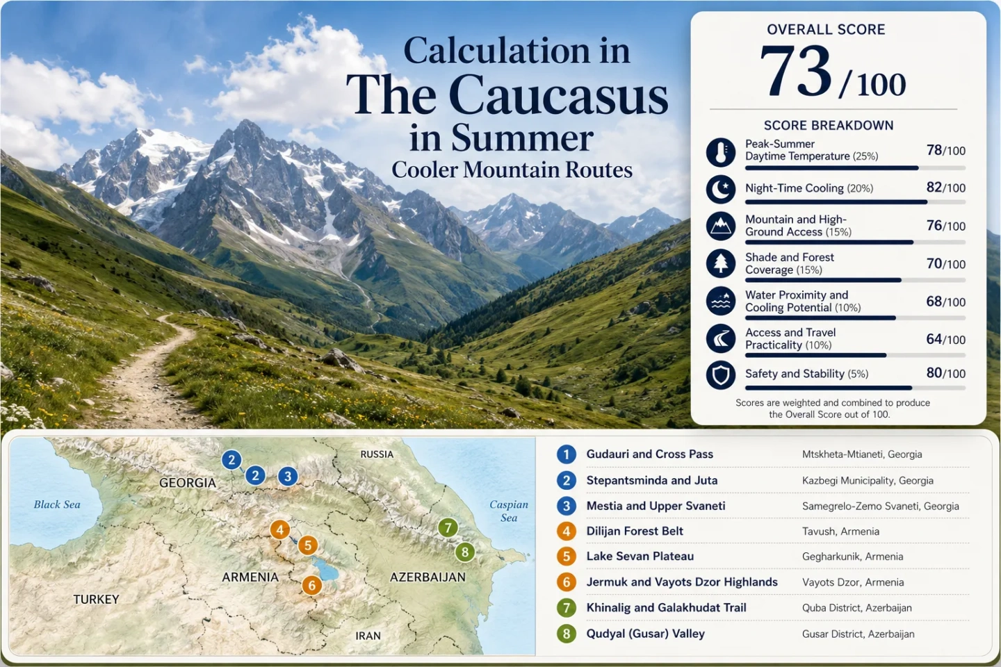
The Caucasus in Summer: Cooler Mountain Routes
Summer heat in the South Caucasus changes faster with elevation and terrain than with national borders. Tbilisi, Yerevan and Baku can be hot while mountain bases a few hours away sit between roughly 1,500 and 2,200 metres, with even higher walking or road extensions. The useful distinction is not simply “mountains versus cities”: Gudauri relies on exposed altitude, Stepantsminda on very cool nights, Dilijan on forest cover, Lake Sevan on a high water plateau, Jermuk on high forest-and-river terrain, and Khinalig on a village-and-trail band above 2,100 metres. These mechanisms create different kinds of summer relief, and the road or border can become the limiting factor before the temperature does.
Three Georgian corridors, three Armenian highland systems and two Azerbaijani Greater Caucasus routes form the common comparison set.
Several route extensions climb higher: Juta reaches 2,200 m, the Khinalig–Galakhudat trail reaches 2,300 m, and Upper Svaneti rises above Mestia toward Ushguli.
The cross-route median uses disclosed historical climate inputs; individual route values range from about 18°C at Gudauri to 27°C at Dilijan.
Night-time relief is a major regional advantage, especially around Stepantsminda, Khinalig, Jermuk and the higher Georgian bases.
Dilijan is not the coldest air-temperature route, but its national-park terrain spans 1,070–2,400 m and adds extensive beech and oak forest cover.
Svaneti, Juta and Khinalig add mountain-road friction, while Azerbaijan’s current entry rules prevent treating the three countries as one assumed continuous driving loop.
Summer Cooling Corridors from Svaneti to the Qudyal Valley
The marker set follows the same eight corridors used by the suitability score and route comparison. Each marker represents a planning centre for a wider route: higher trailheads, passes and village extensions are described in the corresponding route card.
Markers show route planning centres, not guaranteed legal parking, exact trailheads or precise viewpoints. Use the route-specific access notes and named Google Maps links before travelling.
Caucasus Mountain Route Cooler Escape Suitability Score
This transparent suitability index compares the same eight mapped corridors across climate, terrain, access and peak-season pressure. It is not an official climate classification and it does not imply that every higher village shares the exact climate of its route-centre proxy.
Weighted total: 91×0.25 + 98×0.20 + 100×0.15 + 75×0.15 + 98×0.10 + 70×0.10 + 60×0.05 = 88.4 → 88/100
Method: Route count adds no bonus points. Each route carries equal weight inside a factor; route-level values or categorical scores are combined using the median before the seven fixed factor weights are applied.
High Roads, Forest Belts and Plateau Water Across the South Caucasus
The same temperature can produce very different summer comfort. Open alpine ground reduces air temperature but increases solar exposure; a forested route can feel easier at a higher measured maximum; a high lake adds wind but little shade; a cold valley can deliver a much stronger overnight reset than its daytime value suggests.
Gudauri and Cross Pass
Gudauri is the clearest rapid-altitude route in the set: the Georgian Military Highway climbs directly from the Tbilisi side into a lodging base above 2,000 metres before continuing across the high corridor toward Kazbegi. Its July–August daytime signal is the lowest of the eight core climate points.
The trade-off is exposure. Sparse tree cover means a cool air temperature can still feel intense in direct midday sun. Wind can improve comfort, but cloud, fog and freight-related traffic controls can change the driving rhythm quickly on this international road.
Stepantsminda and Juta
Stepantsminda is slightly warmer by day than Gudauri in the disclosed climate inputs, yet its approximately 6.6°C July–August minimum signal is much colder. That makes the route notable for overnight cooling rather than simply maximum elevation.
Juta changes the daytime terrain. The village sits around 2,200 metres at the end of the Sno valley road, and the relatively easy walk toward the Chiukhi Massif covers about 4 km in roughly 1.5 hours. The result is a high starting point with little warm low-valley approach on foot.
Mestia and Upper Svaneti
Mestia is the warmest Georgian daytime base in this set, so Svaneti should not be sold as an all-day cold refuge. Its advantage is the combination of cool nights and progressive elevation as the route moves east. The Mestia–Zhabeshi walking route is about 17 km, takes roughly 6–7 hours and reaches about 2,000 metres at Gvaldi Pass.
Higher still, Ushguli sits around 2,050–2,200 metres. From there the Shkhara Glacier walk keeps the overnight base high rather than dropping back to a warmer valley. Road access is the cost: the Mestia–Ushguli corridor is a gravel high-road journey for which local Svaneti information treats 4x4 or shared-jeep transport as the practical standard.
Dilijan Forest Belt
Dilijan has the highest daytime climate proxy among the eight core points, but the number alone misses the route’s main strength. Dilijan National Park extends across mountain slopes from about 1,070 to 2,400 metres and protects broad Caucasian beech and oak forest. Parz Lake, Gosh Lake and stream-cut trails add water and continuous shade to the same travel area.
Shade changes the heat load even when it does not change the official air temperature. A 27°C forest walk and a 27°C open alpine slope do not expose the body to the same amount of direct solar radiation. Dilijan therefore works for travellers who value shaded walking more than the lowest possible thermometer reading.
Lake Sevan Plateau
Lake Sevan offers a different shortcut to elevation: the trip reaches a broad lake basin around 1,900 metres without requiring a rough mountain pass. That makes it one of the easier high-ground transitions from Yerevan and gives the route a large water surface plus frequent open exposure to moving air.
The weak point is the same openness. Shoreline areas can have very little shade, and the water does not erase strong solar load. Weekend and beach demand also concentrates around the most accessible peninsula and waterfront nodes during peak summer.
Jermuk Highlands
Jermuk combines a high overnight base with a much greener cooling system than the exposed Greater Caucasus routes. Forest, the Arpa River gorge, waterfall terrain and the Kechut Reservoir corridor place shade and water close to the town rather than requiring a full-day alpine approach.
The climate proxy sits near 23°C by day and 9°C by night for July–August, with only 5 of 620 daily proxy observations reaching at least 30°C across 2016–2025. The planning cost is distance: the road journey from Yerevan is roughly three hours before local trail or off-road extensions begin.
Khinalig and Galakhudat
Khinalig provides the strongest Azerbaijani high-village signal in the comparison. The core route-centre proxy is about 19.6°C by day and 8.4°C by night, while the marked Khinalig–Galakhudat trail remains between roughly 2,155 and 2,300 metres.
The trail is about 8.2 km. In the Khinalig-to-Galakhudat direction, official route information lists roughly 370 m of ascent and about 3 hours 10 minutes of walking. Water planning matters despite the cool air: the official route note identifies the spring in Khinalig at the beginning of the trail as the only spring on that direction.
Shahdag and Laza
Shahdag gives up some of Khinalig’s extreme high-village character in exchange for easier infrastructure. The resort spans a published elevation band of 1,435–2,552 metres, and its route-centre July–August proxy is about 22.6°C by day and 11.8°C by night.
Laza adds a separate waterfall-and-village branch to the same Qusar mountain system. It is useful for travellers who want river and waterfall terrain rather than a resort-only stay, but the local transfer is less straightforward than simply driving to Shahdag.
What Each Caucasus Route Uses to Reduce Summer Heat
Elevation is only one part of the result. The eight corridors separate into open-alpine, cold-valley, forest, lake-plateau and mixed highland systems, which changes how the same air temperature feels during a full day outdoors.
| Route | Primary cooling mechanism | July–August day / night signal | Higher-ground extension | Access friction | Main summer trade-off |
|---|---|---|---|---|---|
| Gudauri and Cross Pass | Exposed altitude + wind | 18.0°C / 9.7°C | Cross Pass corridor | Medium | Very little shade and road-control sensitivity |
| Stepantsminda and Juta | Cold valley nights + alpine extension | 20.4°C / 6.6°C | Juta at 2,200 m | Medium | Juta adds a dirt-road transfer and strong sun exposure |
| Mestia and Upper Svaneti | Night cooling + progressive altitude | 25.3°C / 9.8°C | Zhabeshi, Ushguli, Shkhara | High | Warmer afternoons at the base and slower high-road movement |
| Dilijan Forest Belt | Canopy shade + mountain terrain | 27.0°C / 13.0°C | National-park slopes to 2,400 m | Low–medium | Higher measured daytime heat than the open alpine leaders |
| Lake Sevan Plateau | High plateau + large lake + wind | 25.5°C / 13.0°C | Mountain hikes around the basin | Low | Open shoreline sun and weekend concentration |
| Jermuk Highlands | High base + forest + river gorge | 23.0°C / 9.0°C | Higher local trails and ridge facilities | Medium | Longer transfer from Yerevan |
| Khinalig and Galakhudat | High-village altitude | 19.6°C / 8.4°C | Marked trail to 2,300 m | High | Vehicle dependence and limited trail water |
| Shahdag and Laza | Altitude + managed mountain access | 22.6°C / 11.8°C | Resort band to 2,552 m | Medium | Summer operations and Laza transfer need separate checks |
Gudauri, Kazbegi and Svaneti Cool Down in Different Ways
Gudauri Trades Shade for Immediate Altitude
Gudauri starts high enough that the road itself performs much of the cooling transition. The benefit is immediate: no long warm-valley hike is required to reach a 2,000-metre base. The penalty is solar exposure. 18°C in open alpine sun is not equivalent to 18°C under a forest canopy.
Stepantsminda’s Advantage Appears After Sunset
The approximately 6.6°C minimum signal is the strongest overnight cooling value in the core set. Juta then adds altitude during the day, so the corridor combines a cold-night base with a high walking start rather than relying on a single elevation number.
Svaneti Becomes Cooler as the Route Moves Beyond Mestia
Mestia’s daytime value is comparatively warm, but the route keeps climbing: Zhabeshi sits around 1,600 m, Gvaldi Pass around 2,000 m and Ushguli around 2,050–2,200 m. The useful model is cool nights plus increasing route altitude, not “Mestia is cold all day.”
A second Georgian high-road pattern sits outside the scored eight-route set: Tusheti’s Abano Pass climbs to about 3,000 metres on a roughly 72 km mountain road that official tourism information describes as a 4WD journey taking at least four hours. The road is generally an end-of-May-to-September access route because snow closes it for much of the year. It demonstrates why a very cool destination can still be a poor substitute when road reliability, rather than heat, is the limiting factor.
Dilijan Shade, Sevan Wind and Jermuk’s High Forest Belt
Dilijan Reduces Direct Solar Load
Dilijan’s climate proxy is warmer than the high-village routes, but national-park beech and oak forest changes the walking environment. The park’s 1,070–2,400 m elevation range also means the town is a base for substantially higher shaded terrain rather than a single fixed-altitude stop.
Sevan Reaches 1,900 Metres Without a Rough Pass
The large lake basin is useful when high elevation is wanted without a mountain-road commitment comparable with Svaneti or Khinalig. Wind can make exposed shorelines feel fresher, but shade is weak and popular waterfront nodes concentrate summer demand.
Jermuk Combines a Cool Base With Forest and Water
Jermuk sits between Sevan’s easy plateau access and the harder high-village routes. The approximately 23°C daytime and 9°C night signals are paired with forest, the Arpa gorge and reservoir terrain, making it a stronger overnight cooling base than its longer road transfer might suggest.
Mountain Roads and Borders Break the Idea of One Continuous Caucasus Loop
Georgia’s main Kazbegi corridor is comparatively straightforward because one highway links Tbilisi, Gudauri and Stepantsminda, but freight traffic, fog and temporary road controls can still change timing. Svaneti is different: reaching Mestia is one problem, while continuing to Ushguli is a separate high-road decision. Local Svaneti road information treats current road status as something to check repeatedly, especially after rain.
Cross-country planning has another constraint. Under Azerbaijan’s current published entry rules, ordinary land-border entry remains permission-based apart from stated exceptions. Since 25 May 2026, rail entry and exit between Azerbaijan and Georgia has been permitted for Azerbaijani citizens and foreign citizens who have the right to enter Azerbaijan visa-free; foreigners are also allowed to leave Azerbaijan by land without the same permission requirement. A Georgia–Armenia–Azerbaijan itinerary therefore should not be sold as a single assumed self-drive circuit.
Late June, Peak Summer and September Change Different Mountain Routes
The useful seasonal question is not whether the Caucasus is “open,” but which high roads, trails and lodging nodes are dependable at the same time. Snow clearance, peak trekking demand and the first colder nights do not move together across the region.
| Travel window | Georgia high roads | Armenia highlands | Azerbaijan mountain routes | Decision value |
|---|---|---|---|---|
| Late June | Juta and higher Svaneti routes move into their main hiking window; recently opened passes can still retain snow or soft road margins. | Dilijan is fully useful as a forest route; Sevan and Jermuk provide altitude without waiting for a single extreme pass. | Khinalig–Galakhudat sits inside the official May–July green-scenery window; high villages remain cool while lower approaches are warmer. | Strong for greenery and long daylight, with more snowmelt uncertainty on the highest roads. |
| July–August | Broadest hiking access, but Stepantsminda and Svaneti carry stronger demand. The 2026 Georgian seasonal outlook also called for summer averages about 1–2°C above climatic norms. | Sevan’s waterfront demand rises; Dilijan keeps its shade advantage; Jermuk retains stronger night cooling than the warmer lowlands. | Khinalig and Shahdag maintain strong altitude relief; water, sun exposure and local transfers matter more than raw air temperature. | Widest route choice, highest booking and road-use pressure. |
| September | Colder nights return quickly at high altitude; Tusheti’s Abano road remains a seasonal proposition and Upper Svaneti margins narrow as weather changes. | Forest and highland routes remain viable with lower heat load; higher mountain walks need more weather margin. | High-village nights cool further while shorter daylight changes longer trail timing. | Useful for lower heat and lighter pressure, with a smaller tolerance for sudden high-mountain weather. |
The lowest air temperature is not automatically the most comfortable choice. Open high routes such as Gudauri and Khinalig maximize altitude relief but offer little shade; Dilijan sacrifices several degrees of daytime coolness for canopy; Sevan exchanges shade for water and wind; Stepantsminda and Jermuk gain much of their advantage after sunset. The strongest route is the one whose cooling mechanism matches the hours spent outdoors and whose access remains practical on the travel date.