Georgia for Cooler Escapes: Caucasus Villages, High Valleys and Mountain Roads
Georgia’s cooler summer geography is concentrated above the hot lowlands: forested resort settlements in Guria and Borjomi, high villages beneath the Greater Caucasus, and road-linked valleys where daytime temperatures fall sharply after gaining elevation. The strongest July–August relief comes from high accommodation bases, cold nights and direct access to mountain terrain, although rain, road restrictions and concentrated seasonal demand can complicate travel.
The route set spans Guria, Samtskhe-Javakheti, Svaneti and the eastern Greater Caucasus.
Median of the six routes’ published mean daily maximum temperatures for the target window.
Its exposed high-mountain setting produces the clearest daytime temperature advantage in the eastern route group.
Gridded July–August minimums near 6.6°C make warm sleeping conditions unlikely, even after sunnier afternoons.
Gudauri and Stepantsminda share the country’s most direct high-altitude corridor from Tbilisi.
Mountain rain, rockfall risk, construction and freight traffic can change journey times with little notice.
Caucasus Villages Across Georgia’s High-Road Network
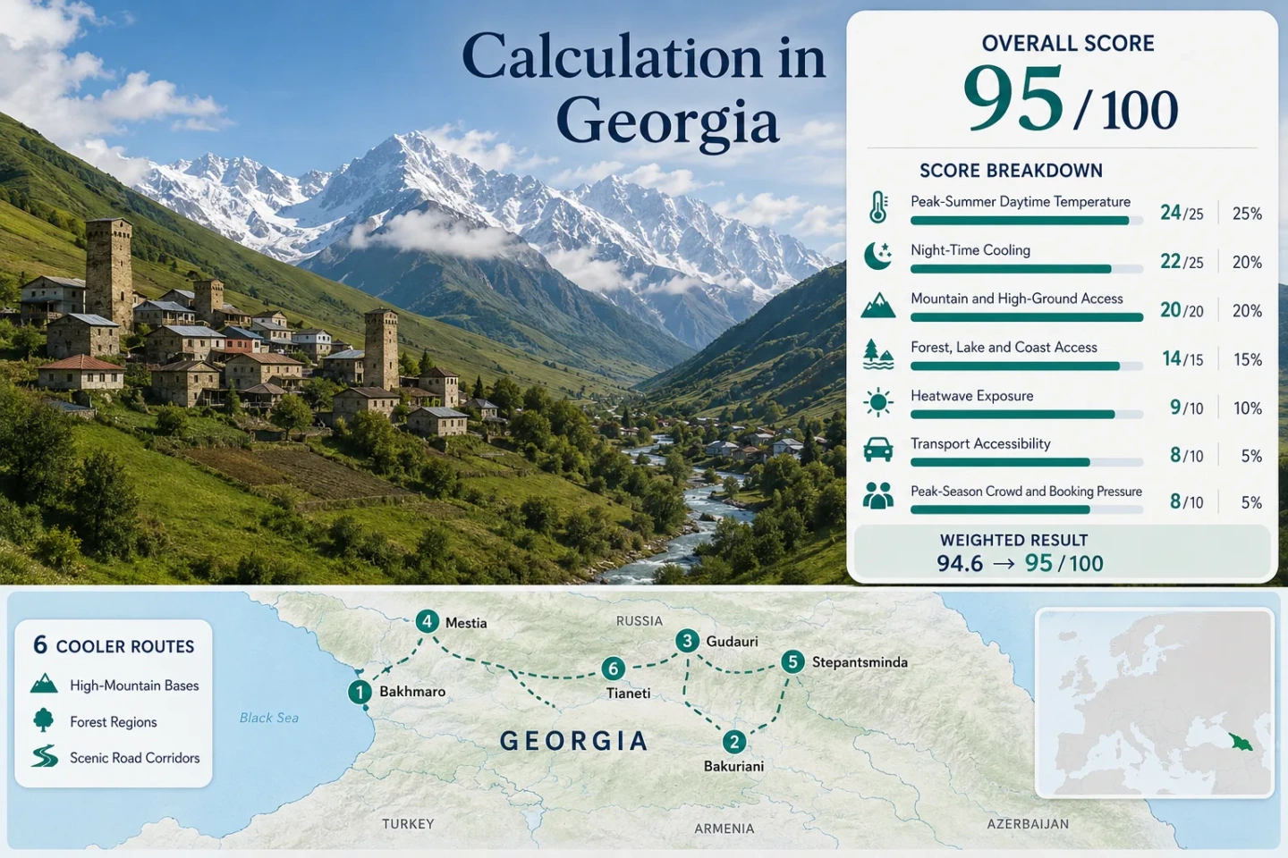
The selected places form three distinct travel patterns: western maritime highlands, the Borjomi forest belt and the northbound Greater Caucasus road corridor. Their locations explain why driving time and road reliability can matter as much as straight-line distance.
This marker map is built for planning orientation. Marker positions use approximate public location centers where exact viewpoints, trailheads, legal parking areas or pull-offs are not specified. Use each route card for Google Maps links and access notes before traveling.
Georgia Highland Cooler Escape Suitability Score
This is a transparent editorial suitability index based on disclosed climate, landscape, access and pressure factors. It is not an official climate classification or a weather forecast.
Weighted total: 100×0.25 + 98×0.20 + 100×0.15 + 100×0.15 + 89×0.10 + 80×0.10 + 60×0.05 = 94.5 → 95/100
Method: Route count does not add bonus points. Each route is equally weighted within a factor, and the route median becomes the factor value.
Comparability note: The daytime and elevation factors use named mountain stations, while night temperatures use mixed gridded and derived values. The heatwave factor is a disclosed climatological estimate rather than a measured daily exceedance count, which limits direct comparison with pages supported by complete daily station series.
High Villages from Guria to the Greater Caucasus
The six bases do not offer the same kind of cooling. Bakhmaro combines maritime cloud, forest and high elevation; Gudauri relies on exposed altitude; Stepantsminda adds exceptionally cold nights; Mestia trades warmer afternoons for deep-valley access and a broader cultural base.
Bakhmaro and Guria’s Maritime Highland
Bakhmaro sits high enough to cool rapidly while remaining exposed to moist air moving inland from the Black Sea. Published long-term means place July near 13.5°C and August near 13.7°C, while mean daily maxima stay close to 18°C. July precipitation is approximately 89 mm and August precipitation approximately 112 mm, so low cloud, fog and wet road surfaces are part of the cooling mechanism rather than occasional exceptions.
The settlement is roughly 337 km by road from Tbilisi and is substantially less convenient than eastern highland bases. Its forested slopes and maritime air make it the clearest low-heat option, but the final mountain approach rewards flexible timing and a vehicle suited to current road conditions.
Bakuriani in the Borjomi Forest Belt
Bakuriani’s strength is balance rather than extreme cold. The 1,665 m base has published July and August mean daily maxima of 21.1°C and 21.5°C. Gridded minimums of approximately 11.8°C and 12.3°C leave enough night relief for buildings to cool naturally.
The resort is linked to Borjomi and has a larger year-round service base than Bakhmaro. Forest access is immediate, while the wider Samtskhe-Javakheti road network opens routes toward high plateaus and Tabatskuri Lake. Public transport is possible, although schedules and the operating status of any heritage rail connection should be checked rather than assumed.
Gudauri on the High Georgian Military Highway
At 2,194 m, Gudauri is the highest accommodation base in the route set. Published station values hold the July–August mean daily maximum at approximately 18°C, while gridded minimums remain near 9.7°C. The landscape is open and alpine rather than heavily forested, so its temperature advantage comes primarily from elevation, wind exposure and rapid evening cooling.
July–August mean daily maximum.
July–August gridded minimum.
Gudauri lies directly on the Georgian Military Highway, creating a relatively simple journey from Tbilisi without a secondary mountain-road detour. That advantage is conditional: roadworks, freight traffic, fog and temporary controls can still slow the corridor.
Mestia and the Forested Valleys of Svaneti
Mestia records warmer summer afternoons than Bakhmaro, Gudauri or Stepantsminda, with a July–August mean daily maximum near 25.3°C. Its value emerges after sunset: gridded minimums remain close to 9.8°C, creating a large day-to-night range that can reset lodging temperatures.
The town also offers immediate access to the Mestiachala and Enguri river systems, forested side valleys and higher trailheads. It functions as a substantial mountain base rather than a small seasonal settlement, but this broader appeal increases July–August booking pressure.
Stepantsminda and the Cold Nights of the Terek Valley
Stepantsminda’s 1,744 m base combines moderate summer afternoons with the coldest night signal in the route set. Published July–August mean daily maxima average approximately 20.4°C, while gridded minimums average only 6.6°C.
Difference between the route’s daytime and night climatology signals.
Road-based public transport runs from Tbilisi through Gudauri.
The Terek valley is less forested than Bakuriani or Bakhmaro, but its elevation, exposed terrain and cold-air drainage deliver reliable overnight relief. Rain, cloud and rapidly changing visibility remain more consequential than afternoon heat.
Tianeti as an Accessible Iori Valley Alternative
Tianeti is the lowest base in the route set at 1,099 m and has the warmest published daytime signal, averaging about 25.4°C across July and August. Nights remain substantially cooler at approximately 11.6°C, preserving a meaningful advantage over lower parts of eastern Georgia.
The practical gain is proximity. Tianeti can be reached without committing to the Georgian Military Highway’s international freight corridor or Svaneti’s long western approach. The Iori valley, nearby forest and Sioni Reservoir corridor add shaded and water-adjacent options when midday temperatures rise.
Six Routes, Six Different Cooling Trade-offs
Every route shown on the map and used in the score appears in this decision matrix. Day and night signals represent the July–August values used in the climate assessment rather than short-range forecasts.
| Route | Main Cooling Mechanism | July–August Day / Night Signal | Access Pattern | Main Trade-off |
|---|---|---|---|---|
| Bakhmaro | High elevation, Black Sea air, forest and cloud | 18.0°C / 9.3°C | Long western road approach; arranged transport often useful | Very low heat, but rain, fog and seasonal road sensitivity |
| Bakuriani | 1,665 m base and conifer forest | 21.3°C / 12.1°C | Road and public transport connections through Borjomi | Balanced services and access, with more resort demand |
| Gudauri | Exposed altitude and mountain wind | 18.0°C / 9.7°C | Direct Georgian Military Highway corridor | Easy high-altitude reach, but sparse forest and road disruption risk |
| Mestia | Cold nights, river valleys and forest access | 25.3°C / 9.8°C | Long road from Zugdidi or weather-sensitive flight | Warmer afternoons and stronger booking pressure |
| Stepantsminda | Cold-air drainage in the high Terek valley | 20.4°C / 6.6°C | Direct road transport through Gudauri | Exceptionally cold nights, with rain and freight-corridor exposure |
| Tianeti | Moderate elevation, forest and reservoir corridor | 25.4°C / 11.6°C | Shorter regional road connection from Tbilisi | Less daytime cooling in exchange for easier access and lighter pressure |
The Georgian Military Highway Changes the Access Equation
Gudauri Uses the Corridor as an Advantage
Gudauri reaches 2,194 m without leaving Georgia’s principal northbound highway. That makes its elevation unusually accessible from Tbilisi and removes the need for a long secondary-valley approach. Minibuses and road transfers can deliver a car-light stay once accommodation and short local movements are arranged.
Stepantsminda Sits Beyond the Main High Pass
Stepantsminda benefits from the same corridor but lies farther north, beyond the Gudauri and Cross Pass section. Weather, construction, freight queues and temporary traffic controls therefore have more opportunities to affect the journey. A road closure north of Gudauri can isolate the final destination even when the resort itself remains calm.
Bakhmaro and Mestia Depend on Side Roads
Bakhmaro requires a dedicated climb away from Guria’s lower settlements, while Mestia follows a long mountain road from Zugdidi into Svaneti. Neither shares the eastern corridor’s directness. Their stronger forest and maritime influences come with longer transfers and fewer simple fallback connections.
Road decision: Check the Roads Department of Georgia on both arrival and departure days. A clear forecast at the accommodation base does not confirm that the entire approach road is unrestricted.
Black Sea Air Reaches Bakhmaro but Not Tianeti in the Same Way
Bakhmaro Converts Maritime Moisture into Cooling
Air arriving from the Black Sea rises across western Georgia and reaches Bakhmaro’s high forest belt with greater cloud, fog and precipitation potential. This suppresses daytime temperatures but also increases wet-road exposure. July and August long-term mean temperatures remain near 13.5–13.7°C, an unusually low signal for a Georgian summer settlement.
The result is cooler but less predictable outdoor timing. Clear mornings can close into cloud, and the coldest-feeling periods may coincide with reduced visibility rather than blue-sky weather.
Tianeti Keeps a More Continental Daily Rhythm
Tianeti lies east of Georgia’s strongest maritime influence and at a substantially lower elevation. Its mean July–August daily maximum is roughly 7.4°C above Bakhmaro’s, but clear-sky nights still fall toward 11–12°C.
This produces a more familiar high-valley pattern: warmer afternoons, cooler evenings and fewer reasons for persistent fog. Tianeti therefore suits short heat-escape trips where road simplicity matters more than obtaining the lowest daytime temperature.
Cold Valley Nights Matter More Than Midday Altitude
A high base is valuable only when lodging can release accumulated daytime heat. Georgia’s mountain valleys show large day-to-night temperature ranges, making building ventilation, sun exposure and room position important route variables.
Stepantsminda Has the Largest Reset
A daytime signal near 20.4°C and a night signal near 6.6°C create the widest cooling range in the set. Warm rooms can cool rapidly after sunset, but outdoor evening plans require a proper insulating layer.
Mestia Recovers After Warmer Afternoons
Mestia may reach the mid-20s on an average summer afternoon, yet nights near 10°C restore comfort. Its suitability depends more on overnight relief than on maintaining low temperatures throughout the day.
Bakuriani Offers a Milder Sleeping Range
Minimums near 12°C remain cool without approaching the single-digit values of Stepantsminda. This is a practical range for families or travelers who find the coldest Caucasus nights uncomfortable.
Lodging check: South-facing rooms, sealed upper floors and limited cross-ventilation can feel warmer than the route climatology suggests. Window configuration may matter more than air-conditioning at the highest bases.
June Openings, July Pressure and September Road Margin
| Travel Period | High-Road Access | Temperature Advantage | Booking Pattern | Weather Trade-off |
|---|---|---|---|---|
| Mid to late June | Most settlement roads are normally usable, but higher trail access can remain affected by snowmelt and wet ground. | Very strong daytime cooling, especially at Bakhmaro, Gudauri and Stepantsminda. | Generally lighter than the central school-holiday period. | Higher rainfall and unstable mountain cloud can reduce hiking continuity. |
| July and August | Broadest visitor access and transport availability, subject to temporary road controls. | The assessed window; route median daytime maximum is approximately 20.8°C. | Mestia, Stepantsminda, Bakuriani and concentrated Bakhmaro lodging require earlier decisions. | Thunderstorms, fog and isolated warm afternoons remain possible. |
| Early to mid-September | Roads generally remain usable, while reduced seasonal services may begin to affect remote transfers. | Cooler nights strengthen quickly, particularly in the Greater Caucasus. | Pressure eases after the main domestic and international holiday period. | Shorter daylight and colder wet spells reduce the margin for long road or trail days. |
Practical split: July–August provides the broadest operating window. Early September can improve booking flexibility, but a late arrival and shorter daylight leave less recovery time after road delays.