Bhutan Coolcation Routes: Forest Roads, Mountain Valleys and Calm Summer Travel
Bhutan's western and central valleys combine high sleeping elevations, pine and broadleaf forests, river corridors and cool monsoon nights. July and August are not dry-season months: the temperature advantage is real, but rain, cloud, road delays and occasional landslide or flash-flood disruption shape every route beyond Paro and Thimphu.
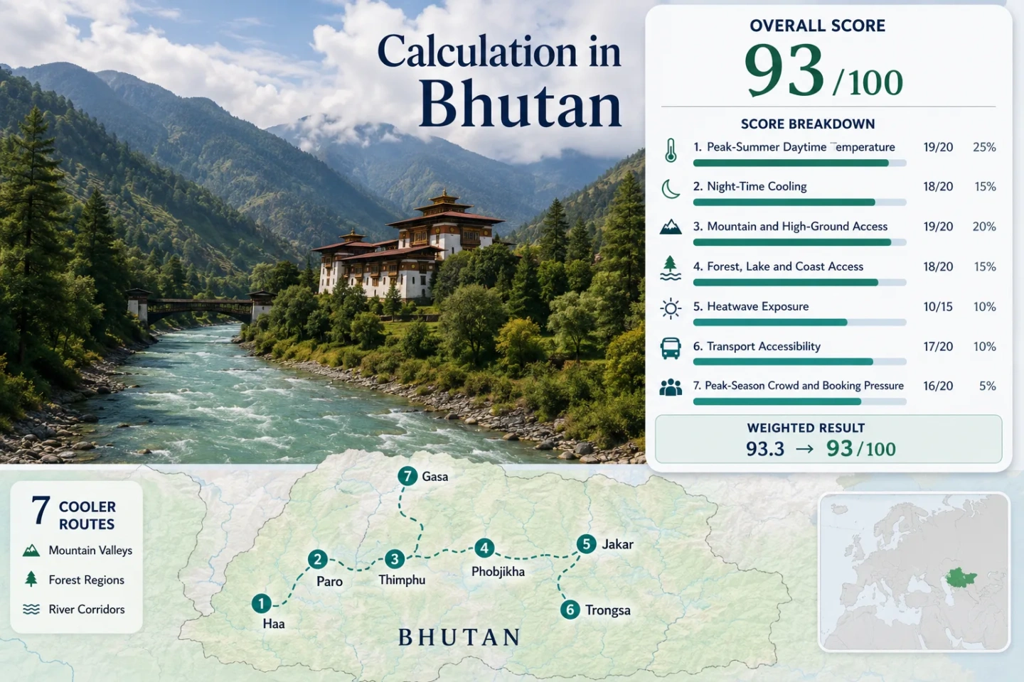
The same seven places appear in the map, score calculation, route cards and comparison matrix.
Only Trongsa sits close to 2,100 m; the other selected bases retain a stronger elevation advantage.
Published NCHM July-August temperature maps place both route centres near a 20°C mean daytime-maximum band.
The international airport, national bus hub and denser taxi network make these the simplest bases without a dedicated vehicle.
Rain often arrives in concentrated periods, while cloud, wet roads and drainage incidents can slow mountain transfers.
National arrivals were much lower in July and August 2024 than during the spring and autumn peaks, but longer central-road journeys need time buffers.
Western Valleys and the Central Mountain Road
The route set begins around Bhutan's western air gateway, crosses the central forested spine and adds Gasa as a separate northern branch. Marker numbers match the route cards.
This marker map is built for planning orientation. Markers use approximate public location centres, not guaranteed legal parking, trailheads or exact viewpoints. Use the Google Maps links and current local access advice before travelling.
Bhutan Highland Cooler Escape Suitability Score
This is a transparent editorial suitability index based on disclosed temperature, landscape, access and pressure factors. It is not an official climate classification or a weather forecast. Monsoon rainfall is treated as a planning constraint rather than a hidden eighth factor.
Method: Official gridded-climatology map sampling. July and August monthly mean maximum-temperature colours were sampled at each route-centre coordinate from the NCHM Climate Atlas, then averaged by route. The seven route values were reduced to the median and normalized with the fixed temperature scale.
Raw: Route median 21.4°C; 21°C scores 100 and 23°C scores 90, giving 98 by linear interpolation.
Route values: Haa 20.3°C; Paro 22.7°C; Thimphu 22.9°C; Phobjikha 20.3°C; Jakar / Bumthang 21.4°C; Trongsa 22.9°C; Gasa 20.2°C.
Source mapping: Published map pixels were sampled at route centres: Haa 27.3864, 89.2785; Paro 27.4305, 89.4133; Thimphu 27.4728, 89.6390; Phobjikha 27.4520, 90.1810; Jakar 27.5490, 90.7525; Trongsa 27.5026, 90.5072; Gasa 27.9030, 89.7269. Values are planning approximations, not station-precision readings.
Period: 1996-2025 baseline climatology; July and August.
Sources: NCHM Climate Atlas of Bhutan 1996-2025; NCHM climate resources.
Method: The same official gridded-map procedure was applied to July and August monthly mean minimum temperature. The arithmetic mean of both monthly samples produced each route value; the route median was then normalized.
Raw: Route median 13.6°C, within the fixed 10-16°C full-score band.
Route values: Haa 11.1°C; Paro 14.1°C; Thimphu 13.6°C; Phobjikha 11.5°C; Jakar / Bumthang 12.7°C; Trongsa 15.4°C; Gasa 13.9°C.
Source mapping: Same seven route-centre coordinates as the daytime factor. The atlas variable is monthly mean minimum temperature in °C; map resolution limits the reported precision.
Period: 1996-2025 baseline climatology; July and August.
Sources: NCHM Climate Atlas of Bhutan 1996-2025.
Method: Fixed categorical rubric using the overnight base elevation. A base at 900 m or above scores 100; route scores are equally weighted and reduced to the median.
Raw: Median route score 100.
Route scores: Haa 100 - base about 2,670 m; Paro 100 - about 2,200 m; Thimphu 100 - about 2,320 m; Phobjikha 100 - about 2,900 m; Jakar / Bumthang 100 - about 2,500 m; Trongsa 100 - about 2,100 m; Gasa 100 - about 2,320 m.
Period: Current route geography reviewed July 15, 2026.
Sources: Bhutan Department of Tourism; NCHM national elevation and temperature context.
Method: Fixed access rubric. Each route was checked for two strong cooling-adjacent landscape elements within about 30 minutes: substantial forest plus a river, wetland or lake system.
Raw: Median route score 100.
Route scores: Haa 100 - forest slopes and Haa Chhu; Paro 100 - forest approaches and Paro Chhu; Thimphu 100 - forested valley edges and Wang Chhu; Phobjikha 100 - wetland basin and conifer forest; Jakar / Bumthang 100 - forest and Chamkhar Chhu; Trongsa 100 - forest ridges and the Mangde Chhu system; Gasa 100 - extensive forest and northern river corridors.
Period: Current physical access reviewed July 15, 2026.
Sources: Bhutan eco-tourism information; Bhutan wildlife and nature information; NCHM State of Climate Report 2024.
Method: Official threshold-count upper-bound fallback. NCHM publishes annual 2024 counts of days with maximum temperature at or above 30°C. Because July-August counts cannot exceed annual counts, those official annual values provide a conservative route screen without inventing an unqueried daily series.
Raw: Median annual upper bound 0 days at or above 30°C, equivalent to a 0% median target-window exposure and a score of 100.
Route values: Haa 0; Paro 6; Thimphu mapped to Babesa 1; Phobjikha represented by Trongsa 0; Jakar mapped to Chamkhar 0; Trongsa 0; Gasa 0. Values are annual counts, so target-window exposure is no greater than the number shown.
Coverage: 7 of 7 routes use a published station count or an explicitly named representative station. No incomplete daily series is treated as an exact count.
Period: Calendar year 2024; official threshold-frequency fallback.
Sources: NCHM State of Climate Report 2024, annual station statistics.
Method: Fixed route-access rubric: 100 for strong year-round public transport and short transfers; 80 for regular public transport with a manageable final connection; 60 for limited service with workable alternatives; 40 for infrequent service or a private vehicle commonly needed; 20 for difficult public access; 0 for no practical route.
Raw: Median route score 40.
Route scores: Haa 60 - road access from Paro with limited scheduled options; Paro 100 - international airport, taxis and road services; Thimphu 100 - principal bus hub and dense taxi supply; Phobjikha 40 - road access with limited local service; Jakar / Bumthang 40 - long road journey or schedule-dependent domestic flight; Trongsa 40 - long mountain-road transfer and limited bus frequency; Gasa 20 - long northern branch with thin scheduled service.
Period: Current network reviewed July 15, 2026. Timetables and domestic flights remain subject to change and weather.
Sources: Bhutan Department of Tourism transport overview; Bhutan Construction and Transport Authority transport services; BCTA historical passenger-bus schedule notice used only to classify relative service frequency.
Method: Fixed categorical pressure rubric using national monthly arrivals as the comparable demand signal, then adjusting route scores only for known gateway concentration and local lodging depth. Lower booking pressure scores higher.
Raw: Median route score 80. Bhutan recorded 2,627 arrivals in July and 5,092 in August 2024, compared with 23,547 in May and 20,542 in October.
Route scores: Haa 100 - limited summer concentration; Paro 60 - gateway demand and flight-linked stays; Thimphu 60 - capital and business demand; Phobjikha 80 - moderate lodging capacity but lower summer pressure; Jakar / Bumthang 80 - thinner supply balanced by lower monsoon demand; Trongsa 100 - mostly transit-scale summer demand; Gasa 100 - remote, low-volume access.
Period: January-December 2024 national arrival series; route classification reviewed July 15, 2026.
Sources: Bhutan Department of Tourism Monthly Tourism Bulletin, December 2024.
Route count does not add a bonus; every route carries equal weight before the factor median is calculated. Rainfall, humidity and cloud are described in planning sections but are not given undisclosed score weight.
High Valleys, Forest Roads and Cooler Night Bases
The western trio is easier to combine without long transfers. Phobjikha, Trongsa and Jakar create the main central-road sequence; Gasa works more naturally as a separate northern branch from the Punakha side.
Haa Valley
Haa is the clearest western-valley choice for low daytime heat without committing to the long central highway. Forested slopes, the Haa Chhu corridor and the valley's high floor create a cooler base than lower western river settlements.
Access pattern: Road transfer from Paro, often via the Chele La corridor when conditions permit. Scheduled public options are limited enough that a driver or arranged vehicle usually gives more control.
Paro Valley
Paro combines a high valley floor with the country's easiest arrival logistics. The route climatology is warmer than Haa or Phobjikha but still far removed from Bhutan's hot southern foothills, and the airport makes it a practical acclimatization base.
The official 2024 station table recorded six days at or above 30°C across the entire year, establishing a low annual upper bound for July-August heat exposure.
Thimphu Valley
Thimphu is the service-rich route in the set: buses, taxis, medical access and a wider accommodation range reduce logistical friction. The valley remains elevated, but built-up areas and lower slopes can feel less cool than Haa or Phobjikha on bright breaks between rain bands.
Weather context: The Babesa station recorded one 30°C-or-warmer day in all of 2024. A Dechencholing flash flood on August 10, 2024 also shows why drainage and local advisories matter during intense storms.
Phobjikha Valley
Phobjikha's broad glacial valley, wetland floor and surrounding conifer forest create a different summer rhythm from Bhutan's narrow river gorges. The official Gangtey Nature Trail is roughly 4-5 km, giving a short forest-and-valley walk that does not require a high alpine commitment.
Public transport is limited, and the final road approach is more vulnerable to rain-related delays than the Paro-Thimphu corridor.
Jakar / Bumthang
Jakar anchors the central high valleys with pine forest, the Chamkhar Chhu and a cooler station record than Bhutan's lower basins. It is a strong multi-night base, but reaching it by road requires a long sequence of bends and passes from the west.
Domestic air service can shorten the transfer when operating, although schedules and weather make it unsuitable as the only tightly timed connection.
Trongsa
Trongsa is less a detached valley retreat than a strategic ridge base on the western-central crossing. Forested slopes and the deep Mangde Chhu system create strong relief, while the town breaks the long road between Phobjikha and Jakar.
The July-August night map value is about 15.4°C, the warmest median-night estimate in this seven-route set but still inside the full night-cooling score band.
Gasa
Gasa adds the quietest and most remote road-based option, with extensive forest and a cooler annual station profile. NCHM recorded no 30°C days at Gasa in 2024, but also the country's highest station count of rainy days that year.
This is not a casual extension of the central sequence. It works as a separate northern branch with enough schedule margin for road condition checks and slow travel.
How the Seven Valleys Divide by Heat, Access and Monsoon Risk
Temperature values are route-centre samples from the published NCHM July-August maps. They are appropriate for route comparison, not a substitute for a station forecast or a same-day road check.
| Route | Approx. base elevation | July-August mapped max / min | Transport pattern | Main monsoon trade-off |
|---|---|---|---|---|
| Haa Valley | 2,670 m | 20.3°C / 11.1°C | Road from Paro; arranged vehicle useful | Chele La fog and wet bends |
| Paro Valley | 2,200 m | 22.7°C / 14.1°C | Airport, taxis and road links | Gateway demand and flight disruption risk |
| Thimphu Valley | 2,320 m | 22.9°C / 13.6°C | Strongest bus and taxi network | Urban drainage and storm disruption |
| Phobjikha Valley | 2,900 m | 20.3°C / 11.5°C | Limited service; private vehicle common | Final-road delays and local flash-flood risk |
| Jakar / Bumthang | 2,500 m | 21.4°C / 12.7°C | Long road or schedule-dependent flight | Long transfer and river-response risk |
| Trongsa | 2,100 m | 22.9°C / 15.4°C | Long road; limited bus frequency | Winding central highway and landslides |
| Gasa | 2,320 m | 20.2°C / 13.9°C | Remote northern road branch | Frequent rain and thin transport backup |
Dochula, Pele La and the Monsoon Driving Rhythm
Bhutan's cooler routes are connected by elevation, but the same terrain that lowers temperature also slows road movement. Distance alone is a poor transfer measure during the summer monsoon.
Paro, Haa and Thimphu
The western group keeps transfers comparatively compact. Haa adds the strongest temperature relief, while Paro and Thimphu provide transport, accommodation and weather-day flexibility.
Decision point: Keep Chele La and other exposed pass crossings flexible when cloud lowers visibility.
Phobjikha to Trongsa
The central move crosses high forest roads around the Pele La corridor before descending and climbing through deep drainage basins. Rainfall can create localized delays even when both endpoints remain accessible.
Decision point: Treat the day as a transfer with stops, not as spare time around a fixed arrival hour.
Trongsa to Jakar
The road continues through forested mountain terrain to Bumthang. Jakar rewards the additional distance with cool nights and a high-valley base, but a same-day west-to-east rush removes most of the calm-travel advantage.
Decision point: An overnight in Trongsa is often the more resilient sequence during wet weather.
Where Calm Summer Travel Actually Comes From
Haa's Side-Valley Position
Haa sits outside the country's main Paro-Thimphu visitor corridor. Lower accommodation density limits spontaneous choice, but the same separation reduces through-traffic and concentrated gateway demand.
Phobjikha's Broad Basin
The wetland valley spreads movement across a broad landscape rather than a narrow urban strip. Short walks such as the 4-5 km Gangtey Nature Trail make the basin usable between rain periods without relying on a full-day high trek.
Gasa's Access Filter
Gasa's calm comes partly from the cost of reaching it: long road access and limited backup transport suppress casual volume. That remoteness is an advantage only when the schedule can absorb weather delays.
A Resilient July-August Sequence from Paro
The sequence separates the reliable western transport core from the slower central crossing. Gasa remains a branch rather than an add-on to the same road line.
Start with a Western Buffer
Paro, Haa and Thimphu create a flexible opening. A delayed flight or wet pass day can be absorbed without immediately threatening a long central-road booking.
Cross Central Bhutan in Two Stages
Use Phobjikha and Trongsa as separate bases before Jakar. This turns Pele La, the Mangde Chhu terrain and the Bumthang approach into measured travel days rather than one compressed transfer.
Keep Gasa as a Northern Branch
Pair Gasa with the Punakha side of the road network on a separate schedule. Combining it with the full central sequence adds backtracking and increases exposure to cumulative monsoon delays.