Nepal for Mild Summer Alternatives: Hill Towns, Valley Air and Himalayan Views
Nepal’s July–August comfort pattern is shaped less by latitude than by elevation, monsoon exposure and the position of each town relative to the Himalayan rain shadow. High settlements such as Nagarkot, Jomsom and Jumla retain cooler nights, while Pokhara and lower hill towns trade wider services for warmer, wetter afternoons. Himalayan visibility is never guaranteed during the monsoon, so the most practical route combines mild temperatures with flexible transport and enough time for cloud breaks.
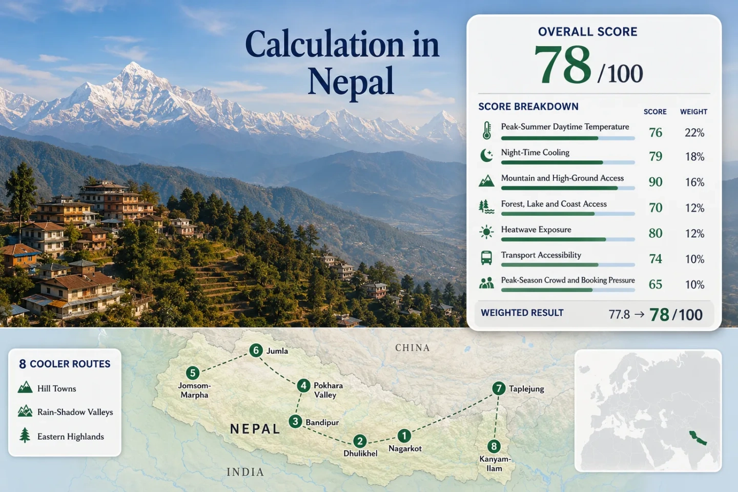
The same destinations appear in the map, score calculation, route profiles and comparison table.
Nagarkot and Jomsom record the lowest July–August average daily maximums in the selected route set.
Average minimum temperatures near 14°C provide a clearer overnight reset than Nepal’s lower valleys.
Nagarkot and Jomsom combine high sleeping elevations with direct access to Himalayan landscapes.
Pokhara receives heavy monsoon moisture while Jomsom lies beyond the main Himalayan rain barrier.
Early mornings and multi-night stays improve the chance of mountain views, but summer cloud can obscure entire ranges.
Hill Towns, Rain-Shadow Valleys and Eastern Mountain Bases
The selected routes extend from the Kathmandu Valley rim to the Kali Gandaki rain shadow, Karnali highlands and tea-covered eastern hills. The wide geographic spread explains why one national summer label cannot describe every stop.
Markers show selected cooler-route planning centers rather than guaranteed legal parking areas, trailheads or exact viewpoints. Use the destination links and current local access information before traveling.
Nepal Hill-Town and Valley Cooler Escape Suitability Score
This transparent editorial suitability index uses disclosed climate, landscape, access and visitor-pressure factors. It is not an official climate classification or a weather forecast. Every route carries equal weight, and route count does not create a score bonus.
Method: Direct Station aggregation using the mean of each station’s July and August normal daily maximum, followed by the median of all eight routes.
Raw: Route-set median 25.225°C, displayed as 25.2°C. Linear normalization between 25°C = 75 and 27°C = 55 produces 72.75, rounded to 73/100.
Route values: Nagarkot 22.3°C; Dhulikhel 25.8°C; Bandipur 29.0°C; Pokhara Airport 30.5°C; Jomsom 22.7°C; Jumla 25.0°C; Taplejung 25.5°C; Kanyam Tea Estate 23.2°C. Median: 25.2°C.
Source mapping: Nagarkot — direct DHM station 1043 at 2,147 m; Dhulikhel — direct route station, with station code not published in the cited monthly annex; Bandipur — direct route station at 991 m, with station code not published in the cited monthly annex; Pokhara — direct DHM Pokhara Airport station 804 at 827 m; Jomsom — direct DHM station 601 at 2,741 m; Jumla — direct DHM station 303 at 2,363 m; Taplejung — direct DHM station 1405 at 1,744 m; Kanyam–Ilam — direct DHM Kanyam Tea Estate station 1416 at 1,570 m.
Period: July–August climate normals, primarily 1991–2020. Bandipur values are marked by DHM as available-period averages.
Sources: DHM July 2025 temperature summary and normal annex; DHM August 2025 monthly report and normal annex.
Method: Direct Station aggregation using each route station’s mean July–August normal daily minimum and the route-set median.
Raw: Median 17.525°C, displayed as 17.5°C. Interpolation from 16°C = 100 to 18°C = 85 produces 88.56, rounded to 89/100.
Route values: Nagarkot 15.6°C; Dhulikhel 18.5°C; Bandipur 20.0°C; Pokhara Airport 22.4°C; Jomsom 14.0°C; Jumla 15.9°C; Taplejung 18.1°C; Kanyam Tea Estate 17.0°C. Median: 17.5°C.
Source mapping: The same direct DHM stations and elevation relationships used for daytime temperature are retained so that daytime and night factors describe identical route centers.
Period: July–August climate normals, primarily 1991–2020; Bandipur uses the DHM-marked available-period average.
Sources: DHM July 2025 climate-normal annex; DHM August 2025 climate-normal annex.
Method: Categorical Rubric based on accommodation-base elevation or regular access to terrain above 1,500 m within approximately 60 minutes.
Raw: Median route score 100/100.
Route scores: Nagarkot 100 — base above 2,100 m; Dhulikhel 100 — hill base above 1,500 m; Bandipur 100 — base near 1,000 m with surrounding high ridges; Pokhara 100 — base at 827 m with regular access toward Sarangkot above 1,500 m; Jomsom–Marpha 100 — valley bases above 2,600 m; Jumla 100 — base above 2,300 m; Taplejung 100 — base above 1,700 m; Kanyam–Ilam 100 — tea-hill base near 1,570 m. Median: 100/100.
Route rationale: Every selected route either sleeps above 900 m or provides regular access to terrain exceeding the rubric’s upper elevation threshold. Pokhara qualifies through nearby high-ground access rather than its valley-floor elevation.
Period: Elevations and access patterns reviewed July 15, 2026.
Sources: DHM State of the Climate of Nepal 2025 station and elevation information; Nepal Tourism Board Nagarkot information; Nepal Tourism Board Pokhara information; Nepal Tourism Board Bandipur information.
Method: Categorical Rubric measuring practical access to substantial forest, lake or river environments rather than scenic reputation.
Raw: Median route score 75/100.
Route scores: Nagarkot 75 — wooded ridge access; Dhulikhel 75 — forested hill and river-corridor access; Bandipur 75 — forested ridges within the local hill system; Pokhara 100 — major lake system plus forested foothills; Jomsom–Marpha 75 — direct Kali Gandaki river corridor; Jumla 100 — forest and Karnali headwater access; Taplejung 100 — extensive forest and major river-valley access; Kanyam–Ilam 75 — tea slopes and forested hill access. Median: 75/100.
Route rationale: Pokhara, Jumla and Taplejung meet the two-feature threshold. The remaining routes provide one strong forest, lake or river element within the practical local travel area.
Period: Physical access and destination conditions reviewed July 15, 2026.
Sources: Nepal Tourism Board Pokhara destination information; Nepal Tourism Board Ilam information; Nepal Tourism Board hill-station information; Department of National Parks and Wildlife Conservation.
Method: Official threshold-frequency checkpoint using DHM’s published count of days with maximum temperature above 30°C in July and August 2025. The common ten-summer daily series preferred by the methodology was not represented as a complete comparable route table in the cited reports.
Raw: Median 1 day from 62 expected target-window days, equal to 1.61%. Interpolation between 1% = 100 and 2% = 90 produces 93.87, rounded to 94/100.
Route values: Nagarkot 0/62 days; Dhulikhel 11/62; Bandipur 27/62; Pokhara Airport 46/62; Jomsom 1/62; Jumla 0/62; Taplejung 1/62; Kanyam Tea Estate 1/62. Median: 1/62 days, or 1.61%.
Source mapping: Each value is the sum of the July and August Tx>30°C counts printed for the direct DHM route station. Monthly annexes report the complete calendar-month count, giving 62/62 expected days for each route-level threshold summary.
Period: July 1–August 31, 2025. This single-summer checkpoint lowers the overall comparability classification and should not be interpreted as a ten-year heatwave climatology.
Sources: DHM July 2025 Tx>30°C station counts; DHM August 2025 Tx>30°C station counts.
Method: Categorical Rubric based on scheduled surface transport, domestic air access, transfer complexity and the degree to which a private vehicle is needed locally.
Raw: Median route score 70/100, calculated from the two middle values of an eight-route set.
Route scores: Nagarkot 80 — short road transfer from the Kathmandu area with bus and taxi options; Dhulikhel 100 — direct scheduled road transport and a walkable center; Bandipur 80 — straightforward highway connection followed by a local uphill transfer; Pokhara 100 — frequent long-distance buses, domestic flights and extensive local transport; Jomsom–Marpha 40 — weather-sensitive air service or a long mountain-road approach; Jumla 40 — limited flights or a long road journey; Taplejung 40 — long eastern road access with weather-sensitive onward movement; Kanyam–Ilam 60 — established road access but longer transfers from major national gateways. Median: 70/100.
Route rationale: Dhulikhel and Pokhara can be planned without a private vehicle. Mustang, Jumla and Taplejung require more buffers because road and air reliability can change during monsoon conditions.
Period: Access structure reviewed July 15, 2026; individual schedules and road conditions must be rechecked before departure.
Sources: Nepal Tourism Board Nagarkot information; Nepal Tourism Board Bandipur information; Nepal Tourism Board Pokhara information; Civil Aviation Authority of Nepal; Department of Roads Nepal.
Method: Categorical Rubric. Comparable route-level July–August accommodation occupancy was not available for all eight destinations, so official tourism statistics, destination prominence and visible transport-capacity constraints were used.
Raw: Median route score 80/100.
Route scores: Nagarkot 60 — regular weekend and short-break demand; Dhulikhel 80 — established accommodation without widespread capacity controls; Bandipur 60 — concentrated historic-center lodging can tighten on weekends; Pokhara 40 — Nepal’s major tourism hub has the broadest booking pressure in the set; Jomsom–Marpha 80 — limited capacity but monsoon demand is below the main trekking seasons; Jumla 100 — low leisure-tourism density; Taplejung 100 — low summer visitor concentration; Kanyam–Ilam 80 — weekend activity without national-scale booking pressure. Median: 80/100.
Route rationale: Pokhara and the Kathmandu Valley rim require more accommodation planning. Jumla and Taplejung have lower tourism pressure, although limited transport can still constrain specific departures.
Period: Latest complete official tourism publication available for the review, combined with destination conditions reviewed July 15, 2026.
Sources: Ministry of Culture, Tourism and Civil Aviation, Nepal Tourism Statistics 2025; Nepal Tourism Board tourism statistics downloads; Nepal Tourism Board Pokhara information.
Weighted total: 73×0.25 + 89×0.20 + 100×0.15 + 75×0.15 + 94×0.10 + 70×0.10 + 80×0.05 = 82.7 → 83/100
Kathmandu Ridges, Gandaki Valleys and Eastern Tea Hills
The route set deliberately mixes accessible hill towns with higher, harder-to-reach settlements. Temperature alone does not determine the practical choice: monsoon cloud, road disruption, flight reliability and the chance of clear Himalayan views can change the value of each base.
Nagarkot Ridge
Altitude is the main advantage. Nagarkot sits high above the Kathmandu Valley floor and records the mildest daytime normal in the route set. The ridge can provide broad Himalayan sightlines when clouds lift, but persistent monsoon cover may replace long views with mist and short visibility windows.
Main caution: Stay more than one night when mountain views matter. A single cloudy morning can remove the destination’s principal visual advantage.
Dhulikhel and the Eastern Valley Rim
Dhulikhel is warmer than Nagarkot but easier to combine with Kathmandu, Banepa and nearby cultural stops. It functions as a car-light hill base rather than an isolated mountain retreat, with regular road connections and a compact center.
The 2025 DHM threshold table recorded 11 July–August days above 30°C, so elevation does not remove short hot spells. Morning walks and shaded afternoon planning remain useful.
Bandipur Hill Town
Bandipur offers a pedestrian historic center and ridge setting, but its measured summer profile is warmer than its hill-town image suggests. The location works more through reduced traffic, ridge airflow and walkable evenings than through consistently low daytime temperatures.
Watch for: Humid afternoons and steep paved lanes after rain. Accommodation near the old center reduces repeated uphill transfers.
Pokhara Valley and Lakeside
Pokhara is the most service-rich base in the set, with domestic flights, long-distance buses, lake access and quick movement toward higher viewpoints. It is also the warmest and most humid selection. Lakeside breezes and nearby hills can improve comfort, but they do not make the valley floor reliably cool.
Works for: Travelers who prioritize transport, restaurants and flexible day trips over the lowest temperatures. Build activities around early mornings and rain breaks.
Jomsom–Marpha and the Kali Gandaki Corridor
The rain-shadow position creates Nepal’s clearest mild-summer contrast. Jomsom and Marpha sit north of the main monsoon barrier, producing cooler nights and substantially drier local conditions than Pokhara. Afternoon valley winds can be strong, so walking and road movement are often more comfortable earlier in the day.
Low local rainfall does not guarantee easy arrival. Flights remain weather-sensitive, and the road from the south passes through wetter, landslide-prone terrain.
Jumla and the Karnali Highlands
Jumla combines a high sleeping elevation with cool nights, forest access and relatively low tourism pressure. It offers a more remote highland experience than the Kathmandu and Gandaki routes, with fewer tourism services and longer recovery time when transport changes.
Good for: Longer itineraries with buffer days. Limited flight capacity and an extended road approach make short, tightly scheduled visits fragile.
Taplejung and the Kanchenjunga Approach
Taplejung provides a cooler eastern hill base and access toward the Kanchenjunga landscape, but summer visibility is highly sensitive to cloud and heavy monsoon moisture. The temperature profile is favorable; the greater challenge is dependable movement along long eastern roads.
Treat distant mountain views as a weather opportunity rather than a fixed itinerary feature. Multi-day stays improve the chance of a short clear interval.
Kanyam–Ilam Tea Hills
Kanyam and Ilam deliver one of the mildest measured daytime profiles in the set. Tea slopes, forested hills and frequent cloud create a green summer landscape, although high humidity, rain and reduced visibility can offset the thermal advantage.
Main trade-off: The air is often mild, but roads can be wet and Himalayan panoramas toward the north are less dependable during sustained monsoon cloud.
Temperature, Monsoon Exposure and Access Trade-Offs
The primary comparison retains all eight scored routes. Temperature values are July–August station normals, while access and monsoon descriptions identify the practical reason a cooler-looking destination may still require a more cautious itinerary.
| Route | Normal Maximum / Minimum | Monsoon Position | Access Pattern | Himalayan View Logic | Main Trade-Off |
|---|---|---|---|---|---|
| Nagarkot | 22.3°C / 15.6°C | Exposed to Kathmandu Valley monsoon cloud | Road access from the capital region | Wide ridge panorama during clear intervals | Excellent temperature profile, unreliable visibility |
| Dhulikhel | 25.8°C / 18.5°C | Humid eastern valley rim | Direct scheduled road transport | Long-range views depend on early clearing | Easier logistics, warmer afternoons |
| Bandipur | 29.0°C / 20.0°C | Central hills with heavy summer moisture | Highway connection plus uphill local transfer | Ridge views can disappear in cloud | Walkable heritage setting, limited thermal relief |
| Pokhara Valley | 30.5°C / 22.4°C | Strong monsoon exposure south of the Annapurna barrier | Flights, frequent buses and local transport | Annapurna views are episodic in midsummer | Excellent services, warm and humid valley floor |
| Jomsom–Marpha | 22.7°C / 14.0°C | Trans-Himalayan rain shadow | Weather-sensitive flight or long mountain road | Dry-valley mountain scenery is locally more open | Strong cooling, fragile arrival logistics |
| Jumla | 25.0°C / 15.9°C | High Karnali valley with summer rain | Limited air capacity or long road journey | Highland scenery rather than a single panorama | Cool nights, low transport flexibility |
| Taplejung | 25.5°C / 18.1°C | Wet eastern Himalayan foothills | Long road access with weather-sensitive links | Kanchenjunga views need a rare clear window | Mild temperatures, demanding monsoon movement |
| Kanyam–Ilam | 23.2°C / 17.0°C | Cloudy and wet eastern tea hills | Established roads from eastern lowland gateways | Distant ranges are secondary to the tea-hill landscape | Mild air, frequent rain and mist |
Pokhara Rain Meets the Kali Gandaki Rain Shadow
Pokhara’s Warm, Moist Valley Floor
Pokhara Airport’s July–August normal maximum is about 30.5°C and its normal minimum is about 22.4°C. The valley lies directly south of the Annapurna–Dhaulagiri barrier, where monsoon moisture produces intense rain, high humidity and extensive cloud. The city remains useful because transport, accommodation and indoor alternatives are abundant, not because it supplies consistently mild air at lake level.
Jomsom’s Dry-Valley Cooling
Jomsom lies beyond the main barrier at roughly 2,741 m. Its selected normal values fall to about 22.7°C by day and 14.0°C at night. The local valley can therefore feel markedly different from Pokhara despite belonging to the same broad north–south travel corridor. Afternoon wind, dust and transport disruption replace heavy local rainfall as the more important planning concerns.
Route decision: Pokhara is the more resilient service base; Jomsom–Marpha supplies the clearer thermal advantage. A combined itinerary needs buffer time because the wetter southern approach can interrupt access even when upper Mustang remains relatively dry.
Nagarkot Cooling versus Dhulikhel Convenience
The Higher Ridge Advantage
Nagarkot’s station sits about 604 m above Dhulikhel’s cited station. That elevation difference corresponds with a July–August daytime normal roughly 3.5°C lower and a night normal nearly 3°C lower. Nagarkot therefore provides the clearer temperature-based escape from Kathmandu’s lower urban environment.
The Easier Car-Light Base
Dhulikhel offers stronger scheduled road access, a broader working town and easier combination with Banepa and nearby cultural sites. It is more practical when transport simplicity matters more than the lowest temperature. Short hot intervals remain possible, as reflected by the 2025 threshold count.
Neither ridge guarantees a Himalayan panorama in July or August. For a view-focused stay, reserve two mornings, keep the schedule flexible and avoid treating a single sunrise session as the only reason for visiting.
Tea-Hill Mildness and Kanchenjunga Cloud Risk
Eastern Nepal contains two different mild-summer propositions: accessible tea landscapes around Kanyam and Ilam, and the longer Kanchenjunga approach through Taplejung.
Kanyam’s Low-Heat Profile
A normal July–August maximum near 23.2°C places Kanyam among the coolest measured daytime locations in the set. Mist and rain support the green tea landscape, but wet roads and reduced visibility are part of the same climate mechanism.
Taplejung’s Longer Commitment
Taplejung remains mild at about 25.5°C by day, yet the journey requires more time and greater tolerance for road delays. It works more naturally as part of a longer eastern Nepal itinerary than as a brief detour for a single mountain view.
Views as a Weather Window
Kanchenjunga sightlines are most credible as a possible reward during a cloud break. Summer planning should value forests, hill settlements and regional culture even when high summits remain hidden.
Flights, Roads and Buffer Days for Mustang, Jumla and Taplejung
Jomsom Connections
Morning flights can be affected by cloud and wind, while the surface route passes through wetter terrain south of the rain shadow. Keep at least one flexible day before an international departure or another fixed reservation.
Jumla Connections
Limited flight capacity and a long road alternative make missed connections more consequential. The cooler highland climate suits slow travel better than a tightly timed two-night visit.
Taplejung Connections
Long eastern approaches cross monsoon-affected hill roads. Road status should be checked close to departure, and the itinerary should retain enough flexibility to stop short of the planned destination when conditions deteriorate.
Before booking: Recheck DHM forecasts, Department of Roads notices and Civil Aviation Authority information. Historical mildness does not remove landslide, flooding, cloud, wind or flight-cancellation risk.