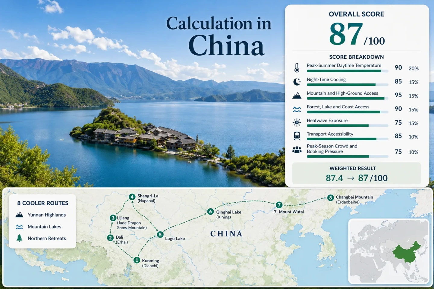
China Heat Escape Routes: Yunnan Highlands, Mountain Lakes and Northern Retreats
China’s lower-elevation cities can be intensely hot in July and August, but the country’s high plateaus create a very different summer pattern. Kunming, Dali, Lijiang and Shangri-La form a rail-linked Yunnan corridor, while Lugu Lake, Qinghai Lake, Mount Wutai and Changbai Mountain add high water, northern forest and cooler-night alternatives. Elevation drives most of the temperature relief; lakes, monsoon cloud, forest cover and northern latitude then change how each route feels from afternoon to overnight.
Four Yunnan bases, two mountain-lake routes and two northern mountain retreats form the shared map, score and comparison set.
The median uses each route’s principal sleeping base rather than its highest summit, pass or scenic viewpoint.
Representative route normals place the portfolio well below the peak-summer daytime conditions common across China’s hotter basins.
Kunming, Dali, Lijiang and Shangri-La can be combined without making a private vehicle the default for every transfer.
The four lake systems differ sharply in altitude, exposure, swimming practicality, urban access and overnight cooling.
Yunnan’s monsoon brings frequent cloud and rain, while limited lakeside rooms and ticketed mountain zones create booking pressure.
From the Yunnan Plateau to Changbai’s Forested Slopes
The route set stretches from Yunnan’s elevated lake basins to the northeastern forests near the China–North Korea border. Marker numbers match the destination cards and the full comparison matrix.
Markers show selected cooler-route regions and approximate public planning centers, not guaranteed legal parking areas, trailheads or exact viewpoints. Use each destination card for Google Maps links and confirm local access arrangements before traveling.
China Highland and Northern Retreat Suitability Score
The index is a transparent editorial suitability measure based on disclosed climate, landscape, access and pressure factors. It is not an official climate classification or a weather forecast. The score covers only the eight routes shown on the map; route count does not add points.
Method: Median July–August average daily maximum for the eight route bases, using direct or representative long-term station normals and published route climatology. Intermediate values follow the fixed linear temperature scale.
Route values: Kunming and Dianchi Lake 24.9°C; Dali and Erhai Lake 23.6°C; Lijiang and Jade Dragon Snow Mountain 23.2°C; Shangri-La and Napahai 19.0°C; Lugu Lake 22.0°C; Qinghai Lake and Xining Gateway 23.5°C; Mount Wutai 17.0°C; Changbai Mountain and Erdaobaihe 25.5°C.
Raw median: 23.35°C. The value falls between the 23°C score of 90 and the 25°C score of 75, producing 87 after rounding.
Station relationship: Urban stations represent Kunming, Dali, Lijiang, Shangri-La and Xining. Lugu Lake, Mount Wutai and Changbai use nearby settlement or route-center climatology because summit and shoreline conditions vary by exposure and elevation.
Period: 1991–2020 normals where available; otherwise the published long-term period stated by the route climatology source.
Sources: China Meteorological Administration data service; WMO climate information for Xining; published Dali July climatology; published Lijiang July climatology; published Erdaobaihe July climatology.
Method: Median July–August average daily minimum for the same route set. The fixed scoring system awards 100 when the median falls between 10°C and 16°C.
Route values: Kunming and Dianchi Lake 17.4°C; Dali and Erhai Lake 16.9°C; Lijiang and Jade Dragon Snow Mountain 13.6°C; Shangri-La and Napahai 9.5°C; Lugu Lake 12.0°C; Qinghai Lake and Xining Gateway 11.5°C; Mount Wutai 8.0°C; Changbai Mountain and Erdaobaihe 15.5°C.
Raw median: 12.8°C. The result measures routine overnight relief at the sleeping bases, not the coldest possible summit temperature.
Route implication: Shangri-La, Qinghai Lake and Mount Wutai may require an insulating layer after sunset, while Kunming and Dali retain milder evenings despite their plateau elevation.
Period: 1991–2020 normals where available, with stated long-term route climatology used for the remaining bases.
Sources: China Meteorological Administration data service; WMO Xining climate information; published Kunming August climatology; published Dali August climatology; published Erdaobaihe climatology.
Method: Each route follows the fixed elevation-and-access rubric. A score of 100 requires a sleeping base at 900 m or higher, or regular access to terrain above 1,500 m within about 60 minutes.
Route scores: Kunming and Dianchi Lake 100 — base near 1,890 m; Dali and Erhai Lake 100 — base near 1,970 m; Lijiang and Jade Dragon Snow Mountain 100 — base near 2,400 m; Shangri-La and Napahai 100 — base near 3,200 m; Lugu Lake 100 — lakeside base near 2,690 m; Qinghai Lake and Xining Gateway 100 — lake shore near 3,200 m; Mount Wutai 100 — principal visitor settlements and temples occupy high mountain terrain; Changbai Mountain and Erdaobaihe 80 — lower sleeping base with managed access toward higher slopes.
Raw median: 100. The exceptionally high result reflects the deliberate route theme rather than China’s national topography as a whole.
Current-status basis: Elevations and normal visitor access patterns reviewed in July 2026. Road, shuttle and scenic-zone conditions can change during storms or maintenance periods.
Sources: China Ministry of Ecology and Environment information on Lugu Lake; UNESCO information on Mount Wutai; Jilin information on the Changbai Mountain area; OpenStreetMap terrain and settlement references.
Method: Physical access is scored rather than scenic reputation. A score of 100 requires at least two strong qualifying elements within about 30 minutes; 75 represents one strong element.
Route scores: Kunming and Dianchi Lake 75 — immediate large-lake access; Dali and Erhai Lake 100 — Erhai plus Cangshan forested slopes; Lijiang and Jade Dragon Snow Mountain 100 — mountain forest and wetland access; Shangri-La and Napahai 100 — seasonal lake-wetland and conifer terrain; Lugu Lake 100 — large lake and surrounding forested mountains; Qinghai Lake and Xining Gateway 75 — immediate large-lake access at the destination; Mount Wutai 75 — extensive mountain forest; Changbai Mountain and Erdaobaihe 100 — forest reserves plus crater-lake and river systems.
Raw median: 100. Lake access does not automatically mean warm-water swimming; Qinghai Lake and high Yunnan lakes can remain cold, exposed or locally restricted.
Current-status basis: Landscape proximity and routine visitor access reviewed in July 2026.
Sources: Lugu Lake environmental information; UNESCO information on Lijiang’s cultural landscape; UNESCO information on Mount Wutai; Changbai Mountain regional information.
Method: Official threshold-frequency fallback, supplemented by published station climatology. A homogeneous public daily archive covering the same recent ten-summer period was not available for every route base, so no exact daily-count claim is made.
Route values: Kunming and Dianchi Lake 0–1% band; Dali and Erhai Lake 0–1%; Lijiang and Jade Dragon Snow Mountain 0–1%; Shangri-La and Napahai 0–1%; Lugu Lake 0–1%; Qinghai Lake and Xining Gateway 0–1%; Mount Wutai 0–1%; Changbai Mountain and Erdaobaihe 0–1%.
Raw median: 0–1% threshold-frequency band, corresponding to 100 under the fixed scale.
Factor coverage: 8 of 8 routes completed through the threshold-frequency fallback. The values describe the selected elevated bases, not nearby lowland cities or access corridors where temperatures can be substantially higher.
Period: Long-term station climatology periods stated by the cited sources. The result is not presented as an observed 2015–2024 daily extraction.
Sources: China Meteorological Administration data service; WMO Xining climate information; published Kunming July climatology; published Lijiang August climatology; published Erdaobaihe July climatology.
Method: Each route follows the fixed public-transport rubric, ranging from 100 for regular direct rail or bus access without a necessary private vehicle to 0 for seriously restricted visitor access.
Route scores: Kunming and Dianchi Lake 100 — major rail, metro and airport hub; Dali and Erhai Lake 100 — direct rail with local bus and taxi connections; Lijiang and Jade Dragon Snow Mountain 100 — direct rail and air access with scenic-zone transport; Shangri-La and Napahai 100 — rail and airport access with local transfers; Lugu Lake 40 — long coach or road transfer and no direct railway; Qinghai Lake and Xining Gateway 60 — Xining is highly accessible but the lake circuit requires a longer road transfer; Mount Wutai 80 — rail or coach access followed by local transfer; Changbai Mountain and Erdaobaihe 80 — rail access to the gateway with managed scenic transport.
Raw median: 90, calculated from the middle two route scores of 80 and 100.
Current-status basis: Network structure reviewed in July 2026. Timetables, ticket-release windows and scenic-zone transfers require date-specific confirmation.
Sources: China Railway ticket platform; Chinese government report on the Lijiang–Shangri-La railway opening; Changbai Mountain regional access information.
Method: Categorical capacity rubric because comparable July–August lodging occupancy is not published for all eight routes. Scores reflect rail and room capacity, ticketed scenic-zone entry, limited lakeside inventory and documented visitor pressure.
Route scores: Kunming and Dianchi Lake 65 — broad urban capacity; Dali and Erhai Lake 40 — concentrated old-town and lakeside demand; Lijiang and Jade Dragon Snow Mountain 40 — major heritage and mountain demand; Shangri-La and Napahai 60 — improving rail capacity but a smaller lodging market; Lugu Lake 40 — limited basin access and lakeside inventory; Qinghai Lake and Xining Gateway 60 — dispersed circuit with seasonal road pressure; Mount Wutai 40 — pilgrimage and summer visitor concentration; Changbai Mountain and Erdaobaihe 40 — ticketed mountain access and concentrated gateway demand.
Raw median: 40. This factor carries a 5% weight, limiting the influence of less-comparable visitor-pressure evidence.
Period: Current access and capacity conditions reviewed in July 2026, supported by the latest available official route and conservation information.
Sources: Ministry of Ecology and Environment discussion of tourism pressure at Lugu Lake; UNESCO information on Lijiang; UNESCO information on Mount Wutai; China Railway ticket platform; Changbai Mountain regional information.
Weighted total: (87 × 25%) + (100 × 20%) + (100 × 15%) + (100 × 15%) + (100 × 10%) + (90 × 10%) + (40 × 5%) = 92.8 → 93/100
Eight High-Altitude, Lake and Northern Bases
The portfolio is not a single continuous road trip. The first four destinations form a practical Yunnan rail sequence, Lugu Lake branches away by road, and the Qinghai, Shanxi and Jilin routes work more naturally as separate regional journeys.
Kunming and Dianchi Lake
Kunming is the easiest transition from a major Chinese city network into highland conditions. The elevation keeps routine summer afternoons moderated, while Dianchi adds open water and western-horizon airflow without requiring a remote overnight base.
Route character: Urban services, airport access and frequent rail connections make Kunming suitable for a gradual altitude transition or a weather-buffer day before continuing west.
Dali and Erhai Lake
Erhai occupies a long north–south basin between the Cangshan range and eastern hills. The lake does not eliminate humid summer weather, but it creates a more open and ventilated setting than a dense inland basin at comparable latitude.
The most useful decision is not simply Dali Old Town versus the lake. Exposure changes around the shore: western bases sit close to Cangshan access, while eastern and northern stays can involve longer transfers and less frequent local connections.
Lijiang and Jade Dragon Snow Mountain
Lijiang combines a high sleeping base with rapid access toward much colder mountain terrain. The city itself provides useful overnight cooling, while the Jade Dragon Snow Mountain corridor creates a much larger elevation range for daytime outings.
Why it stands out: The route delivers cool nights without requiring every night at extreme altitude. Rail and airport access are straightforward, but mountain entry, shuttle and cableway arrangements can be more restrictive than the city transfer.
Shangri-La and Napahai
Shangri-La is the clearest low-heat base in the Yunnan group. Afternoon temperatures are moderated by elevation, nights can become distinctly cold, and the Napahai wetland adds an open high-basin landscape rather than dense urban heat storage.
The Lijiang–Shangri-La railway changed the route from a long road-only extension into a practical rail continuation. Published opening information placed the fastest Lijiang–Shangri-La journey at about 1 hour 18 minutes, though current schedules must be checked for the travel date.
Lugu Lake
Lugu Lake supplies both altitude and a large body of water, with forested mountains enclosing the basin. The shoreline can feel calm in the morning, but open-water wind, rain and cloud can change conditions quickly during the summer wet season.
Unlike the Kunming–Dali–Lijiang–Shangri-La sequence, Lugu Lake remains a branch journey. Long coach transfers or a private road transfer are more common, and moving between scattered shoreline settlements can require additional planning.
Qinghai Lake and Xining Gateway
Qinghai Lake replaces Yunnan’s humid highland pattern with a colder, more exposed plateau environment. Xining works as the rail and airport gateway, but the strongest cooling effect begins after reaching the lake shore and higher surrounding terrain.
The open plateau brings intense sun, wind and rapid temperature loss after sunset. A mild air temperature does not remove dehydration or ultraviolet risk, and shore conditions can feel colder than the thermometer suggests.
Mount Wutai
Mount Wutai offers a northern mountain climate without the very long transfer required for Qinghai or Changbai. Temple settlements occupy high terrain, and the surrounding peaks produce notably cool summer mornings and evenings.
Temperature relief is strong, but the route is not an empty mountain refuge. Religious travel, group tours and summer demand can concentrate movement around Taihuai and the principal temple corridors.
Changbai Mountain and Erdaobaihe
Erdaobaihe is warmer than the high Yunnan and Qinghai bases, yet it provides access to extensive northeastern forest and much higher volcanic terrain. The cooling advantage grows with altitude rather than remaining uniform across the gateway town.
Managed scenic transport controls much of the movement toward the mountain. Fog, rain or wind can affect crater-lake visibility, making a flexible multi-day stay more resilient than a single fixed summit day.
The Yunnan Plateau Rail Spine Changes the Car Question
Kunming, Dali, Lijiang and Shangri-La now form a practical highland sequence. The railway reduces long road exposure and allows altitude to increase in stages rather than through one abrupt transfer.
Kunming to Dali: The Lower Plateau Step
Kunming begins near 1,890 m and Dali near 1,970 m, so the first rail movement adds geographic variety without a major altitude jump. This pairing works well when the priority is moderate daytime temperature, urban services and lake access.
Dali to Lijiang: Cooler Nights Arrive First
Lijiang’s sleeping base is roughly 400 m higher than Dali’s, and the representative July–August night value drops by more than 3°C. The change is usually more noticeable after sunset than during a cloudy monsoon afternoon.
Lijiang to Shangri-La: The Major Altitude Shift
The final rail step climbs toward a base around 3,200 m. Daytime heat risk decreases, but altitude adaptation, colder rain and overnight temperatures near 10°C become more important planning factors.
Lugu Lake Remains the Road Branch
Lugu Lake does not sit on the same rail spine. Adding it between Lijiang and Shangri-La can create substantial backtracking, while treating it as a dedicated side journey preserves more time at the lake.
Dianchi, Erhai, Lugu and Qinghai Create Four Different Summer Patterns
Dianchi: Urban Highland Water
Dianchi is the easiest lake to reach and the least dependent on a separate resort stay. Its cooling value comes from Kunming’s elevation and open western edge rather than a remote shoreline climate.
Erhai: A Long Wind Corridor
Erhai lies between Cangshan and eastern hills, creating strong differences between sheltered lanes, exposed shorelines and mountain-facing villages. Wind can improve daytime comfort but complicate cycling or boat plans.
Lugu: High-Basin Night Cooling
Lugu Lake combines a sleeping elevation near 2,690 m with forested slopes. Its practical constraint is not temperature but road access, shoreline dispersion and limited peak-period inventory.
Qinghai: Cold, Bright and Exposed
Qinghai Lake sits much higher and farther north than the Yunnan lakes. Wind, ultraviolet exposure and rapid night cooling matter more than humidity, and the driving circuit is much larger.
Elevation, Access and Summer Trade-Offs Across All Eight Routes
Temperatures refer to representative July–August route-base conditions, not summit forecasts. Elevations are approximate planning values and can vary substantially within each route.
| Route | Principal Base | Day / Night | Cooling Mechanism | Access Pattern | Main Summer Trade-Off |
|---|---|---|---|---|---|
| Kunming and Dianchi Lake | About 1,890 m | 24.9°C / 17.4°C | Plateau elevation and open lake basin | Major rail, metro and airport hub | Frequent monsoon rain and less dramatic night cooling |
| Dali and Erhai Lake | About 1,970 m | 23.6°C / 16.9°C | High lake basin, wind and Cangshan access | Direct rail plus local shore transfers | Lakeside demand and wet-season cloud |
| Lijiang and Jade Dragon Snow Mountain | About 2,400 m | 23.2°C / 13.6°C | High sleeping base and rapid mountain ascent | Rail or air, then scenic transport | Ticket pressure, ultraviolet exposure and variable visibility |
| Shangri-La and Napahai | About 3,200 m | 19.0°C / 9.5°C | High plateau and strong overnight cooling | Rail or air with local transfers | Altitude adaptation and cold wet weather |
| Lugu Lake | About 2,690 m | 22.0°C / 12.0°C | High lake, forest and basin night cooling | Long coach or road transfer | Scattered shoreline access and limited inventory |
| Qinghai Lake and Xining Gateway | Lake near 3,200 m | 23.5°C / 11.5°C proxy | High plateau, wind and northern latitude | Rail or air to Xining, then road circuit | Distance, exposure and altitude above 3,000 m |
| Mount Wutai | High valley settlement | 17.0°C / 8.0°C proxy | Northern mountain elevation and forest | Rail or coach followed by local transfer | Pilgrimage traffic and very cool nights |
| Changbai Mountain and Erdaobaihe | Gateway near 760 m | 25.5°C / 15.5°C | Northern forest with access to higher volcanic terrain | Rail to gateway, then managed park transport | Fog, ticketed access and weather-dependent summit visibility |
Yunnan Monsoon Clouds, Qinghai Sun and Changbai Fog Require Different Backup Plans
Yunnan’s Cooling Rain Can Disrupt Mountain Days
Kunming, Dali, Lijiang, Shangri-La and Lugu Lake all sit within a summer wet-season pattern. Cloud cover can reduce direct heat, yet repeated showers, low cloud and wet roads may interfere with cableways, viewpoints and long lake circuits.
Qinghai’s Mild Air Does Not Mean Low Exposure
The plateau combines mild temperatures with intense ultraviolet radiation, dry air and wind. Shade can be limited around the lake, and a day that feels cool may still produce rapid sunburn or dehydration.
Changbai Needs More Than One Visibility Window
Crater-lake visibility can change quickly with fog, wind and precipitation. A two- or three-night gateway stay provides more flexibility than building the entire regional journey around one fixed summit attempt.
Rail Tickets, Scenic-Zone Entry and Altitude Shape the Final Itinerary
Reserve the Long Transfers Before Shoreline Details
The Kunming–Dali–Lijiang–Shangri-La rail sequence is the easiest route to structure without a car. Confirming the intercity legs first prevents a desirable lakeside room from creating an impractical transfer day.
Mountain Access Often Uses Separate Entry Systems
Jade Dragon Snow Mountain, Mount Wutai and Changbai Mountain involve more than reaching the nearest city or station. Scenic-zone tickets, shuttle arrangements, operating hours and weather restrictions require separate checks.
Increase Sleeping Altitude in Stages
Kunming and Dali provide a gentler introduction before Lijiang or Shangri-La. Arriving directly from a lowland city at Qinghai Lake or Shangri-La creates a larger physiological jump, even when the air temperature feels comfortable.
Cool Destinations Can Still Have Hot Transfer Days
Rail stations, airports and road junctions may sit in warmer or less shaded conditions than the final lake or mountain base. Water, sun protection and lighter daytime clothing remain useful during transfers before colder evening layers are needed.
Practical check: Confirm current rail schedules through the official China Railway platform, review destination-specific ticket rules, and check short-range mountain forecasts shortly before departure. Lake roads, cableways and summit shuttles can change independently of the intercity transport network.