India for Cooler Summer Travel: Ladakh, Himalayan Hill Towns and Forest Valleys
India’s northern highlands offer several distinct forms of summer relief rather than one uniform cool-weather zone. Leh relies on altitude, dry air and sharp night-time cooling; Gulmarg and Pahalgam combine high bases with Kashmir’s meadows, forests and river valleys; Himachal and Kumaon hill towns trade lower daytime heat for monsoon cloud, wet roads and booking pressure; Gangtok stays mild but receives far more July–August rain. The eight-route set uses the same July–August window so temperature, access, terrain and seasonal pressure can be compared without treating a single cold summit as representative of an entire region.
Ladakh, Kashmir, Himachal Pradesh, Uttarakhand and Sikkim are represented in the same score set.
The median uses July–August 1991–2020 IMD mean maximums for the eight named route bases.
Cool nights are the strongest shared advantage, although Gangtok and Shimla remain milder after dark than Kashmir and Kinnaur.
Its July–August mean maximum is about 20.8°C, with high-ground access extending above the town by gondola.
Only about 0.6 rainy days per month appear in the IMD July and August normals, unlike the monsoon-facing hill towns.
Historically mild daytime temperatures coincide with roughly 25–28 rainy days per month in the target window.
From Ladakh’s Indus Valley to Sikkim’s Monsoon Slopes
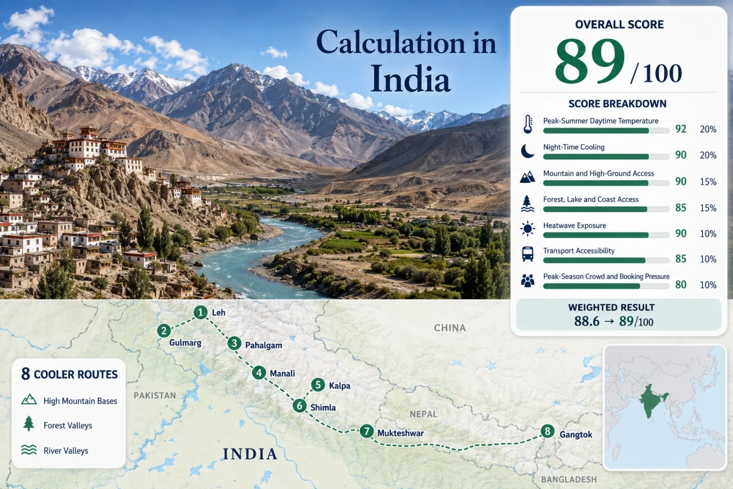
The route set spans dry trans-Himalayan terrain, Kashmir’s forested resort valleys, Himachal ridge towns, a Kumaon forest base and the wet eastern Himalaya. The map is intended for geographic orientation rather than turn-by-turn navigation.
Markers show selected cooler-route regions and approximate public location centres, not guaranteed legal parking, trailheads, viewpoints or road access points. Use each named Google Maps link and the relevant official transport or permit service before travelling.
India Himalayan Cooler Escape Suitability Score
This is a transparent editorial suitability index based on disclosed climate, landscape, access and pressure factors. It is not an official climate classification or a weather forecast. The score applies only to the eight routes shown on the map and in the route portfolio.
Weighted total: 92×0.25 + 100×0.20 + 100×0.15 + 88×0.15 + 100×0.10 + 60×0.10 + 40×0.05 = 89.2 → 89/100
Method: Route count does not add bonus points. Each route carries equal weight inside a factor, route-level values are combined using the median, and the seven fixed weights are then applied.
Dry High Valleys, Cedar Towns and Monsoon Ridges
The route cards keep the same July–August climate window but foreground different constraints: altitude adjustment in Ladakh, gondola and pilgrimage pressure in Kashmir, road exposure in Kinnaur, monsoon rain in the hill towns and permit-mediated excursions in Sikkim.
Leh: Dry Altitude and Strong Night Relief
Leh sits near 3,500 m and records a July–August mean maximum of about 28.3°C with a mean minimum near 15.5°C. Its defining metric is not the lowest daytime temperature in the set; it is the contrast between very low monsoon rainfall, strong solar exposure and cooler nights. IMD normals show roughly 0.6 rainy days in each target month.
Gulmarg: The Lowest Daytime Heat in the Set
Gulmarg’s July–August mean maximum is about 20.8°C and the mean minimum is about 11.9°C. The base is near 2,650 m, while the official gondola rises much higher toward Kongdori and Apharwat. Forest, meadow and upland access are immediate, but the cooler numbers come with roughly eight rainy days per month and a capacity-limited gondola system.
Pahalgam: Lidder Valley Nights and Forest Corridors
At roughly 2,740 m, Pahalgam combines a July–August mean maximum near 25.5°C with a mean minimum near 13.0°C. Evergreen slopes and the Lidder river system give the route a different comfort profile from dry Leh: afternoons are milder than many Indian lowlands, nights cool efficiently, and rain occurs on about nine days per month.
Summer movement can be affected by pilgrimage traffic and controlled access to side valleys, so a quiet-looking map distance may not translate into a quick transfer.
Manali: Beas Valley Shade with Monsoon Road Risk
Manali’s route-base averages are about 25.5°C by day and 16.1°C at night in July–August. The town sits near 2,050 m with immediate conifer forest and Beas river access, while higher ground lies beyond the base. The trade-off is a wetter target window: the IMD normals indicate about 13.9 rainy days per month across July and August.
Road congestion, landslide disruption and Rohtang permit rules can be more decisive than the temperature average.
Kalpa: Kinnaur Altitude with a Longer Road Commitment
Kalpa sits near 2,960 m and holds a July–August mean maximum near 22.6°C with a mean minimum near 12.8°C. About 5.5 rainy days per month place it between dry Leh and the wetter central or eastern hill towns. The temperature profile is strong, but the access score is lower because reaching Kinnaur normally requires a long, staged mountain-road journey.
Shimla: Rail Access, Ridge Air and Heavy Monsoon Frequency
Shimla is the strongest car-light base in the set because the hill city is served by the Kalka–Shimla railway as well as regular buses. Its July–August mean maximum is about 22.8°C and mean minimum about 16.3°C. Those mild figures coincide with approximately 16.4 rainy days per month and frequent fog, so visual conditions and road speed can vary sharply.
Mukteshwar: Kumaon Forest Cooling without Direct Rail
Mukteshwar stands at 2,286 m amid conifer forest and fruit-growing slopes. The route-base mean is about 21.2°C by day and 14.1°C at night in July–August, making it one of the gentlest temperature profiles in the set. Rain is frequent, averaging about 14.4 days per month, and the final 74 km from Kathgodam station remains a road journey.
The appeal is forest-edge quiet and night cooling, not high-capacity transport or a dry sky.
Gangtok: Mild Days on a Very Wet Eastern-Himalayan Ridge
Gangtok’s July–August mean maximum is about 21.9°C, but its mean minimum is higher than most routes at 17.7°C. IMD normals show roughly 26.6 rainy days per month, making cloud, wet roads and slope conditions central to the decision. The base is near 1,650 m, while regulated excursions toward Tsomgo and other protected areas require permit-aware planning.
Why Leh and Gangtok Solve Different Heat Problems
The western and eastern ends of the route set can post similarly mild-looking summer numbers while creating completely different daily routines.
Leh has the highest route-base daytime mean in the set, yet dry air, minimal monsoon rain and a 15.5°C mean minimum create a large day-to-night swing. Shade, hydration and acclimatisation matter more than rain planning.
Gangtok’s daytime mean is lower, but the night mean remains around 17.7°C and rain occurs on most target-window days. The air can feel mild while roads, viewpoints and outdoor timing remain weather-dependent.
Gulmarg and Pahalgam combine cool nights, forest or meadow access and moderate monsoon frequency. They avoid Leh’s altitude dryness and Gangtok’s near-daily rain, but introduce gondola, pilgrimage and road-capacity constraints.
Eight Routes Compared by Heat, Rain and Car Dependence
The table uses the same names and route set as the map and score. Rainy-day values are the mean of the IMD July and August normals, while access descriptions refer to the accommodation base rather than optional high-altitude excursions.
| Route | Mean Max | Mean Min | Rainy Days / Month | Base Access | Main Trade-Off |
|---|---|---|---|---|---|
| Leh | 28.3°C | 15.5°C | 0.6 | Flight or long road | Dry air and strong sun at very high altitude |
| Gulmarg | 20.8°C | 11.9°C | 8.3 | Road from Srinagar | Gondola inventory and day-visitor pressure |
| Pahalgam | 25.5°C | 13.0°C | 8.9 | Road from Kashmir gateways | Pilgrimage traffic and controlled side-valley movement |
| Manali | 25.5°C | 16.1°C | 13.9 | Long-distance bus or road | Monsoon disruption and pass-permit planning |
| Kalpa | 22.6°C | 12.8°C | 5.5 | Long staged road journey | Strong climate profile with lower transport simplicity |
| Shimla | 22.8°C | 16.3°C | 16.4 | Rail and regular bus | Fog, rain and central parking pressure |
| Mukteshwar | 21.2°C | 14.1°C | 14.4 | Railhead plus road | Frequent rain and limited car-light mobility |
| Gangtok | 21.9°C | 17.7°C | 26.6 | Air gateway plus mountain road | Near-daily monsoon rain and permit-based high routes |
Rail, Gondola and Permit Systems Can Override the Climate Ranking
The Kalka–Shimla railway and regular buses make Shimla the clearest public-transport choice. Rain and fog remain substantial, but arrival does not depend on a private vehicle or a single aerial lift.
The town remains accessible by road even without a gondola ticket, but the high-ground component changes when official inventory is unavailable or operations pause. Temperature alone does not guarantee the intended mountain day.
Manali works as a cooler town base without crossing Rohtang, yet many summer itineraries depend on regulated pass access. Permit status, rainfall and road advisories should be checked as separate decisions.
Gangtok itself is a normal city base, while Tsomgo, Nathula and several northern corridors use permit systems and registered operators. The route can remain mild even when the desired high-altitude extension is unavailable.
When to Shift from Monsoon Hills toward the Trans-Himalaya
July and August are not interchangeable across northern India. The same two-month score window contains dry high-desert travel, Kashmir’s moderate monsoon exposure and very wet eastern-Himalayan conditions.
Leh and Kalpa become more practical as high-road access stabilises, while Shimla, Manali, Mukteshwar and Gangtok move deeper into monsoon conditions. Snowmelt, road repair and pass status still require live confirmation.
Dry-weather priority shifts toward Ladakh. Kashmir keeps cooler temperatures with moderate rain, while central and eastern hill towns offer milder air at the cost of frequent wet days, fog and slope disruption.
September falls outside the score window but can reduce monsoon pressure in several hill towns. Daylight shortens, nights cool further and some seasonal transport or high-road services begin changing, so route-specific schedules matter.