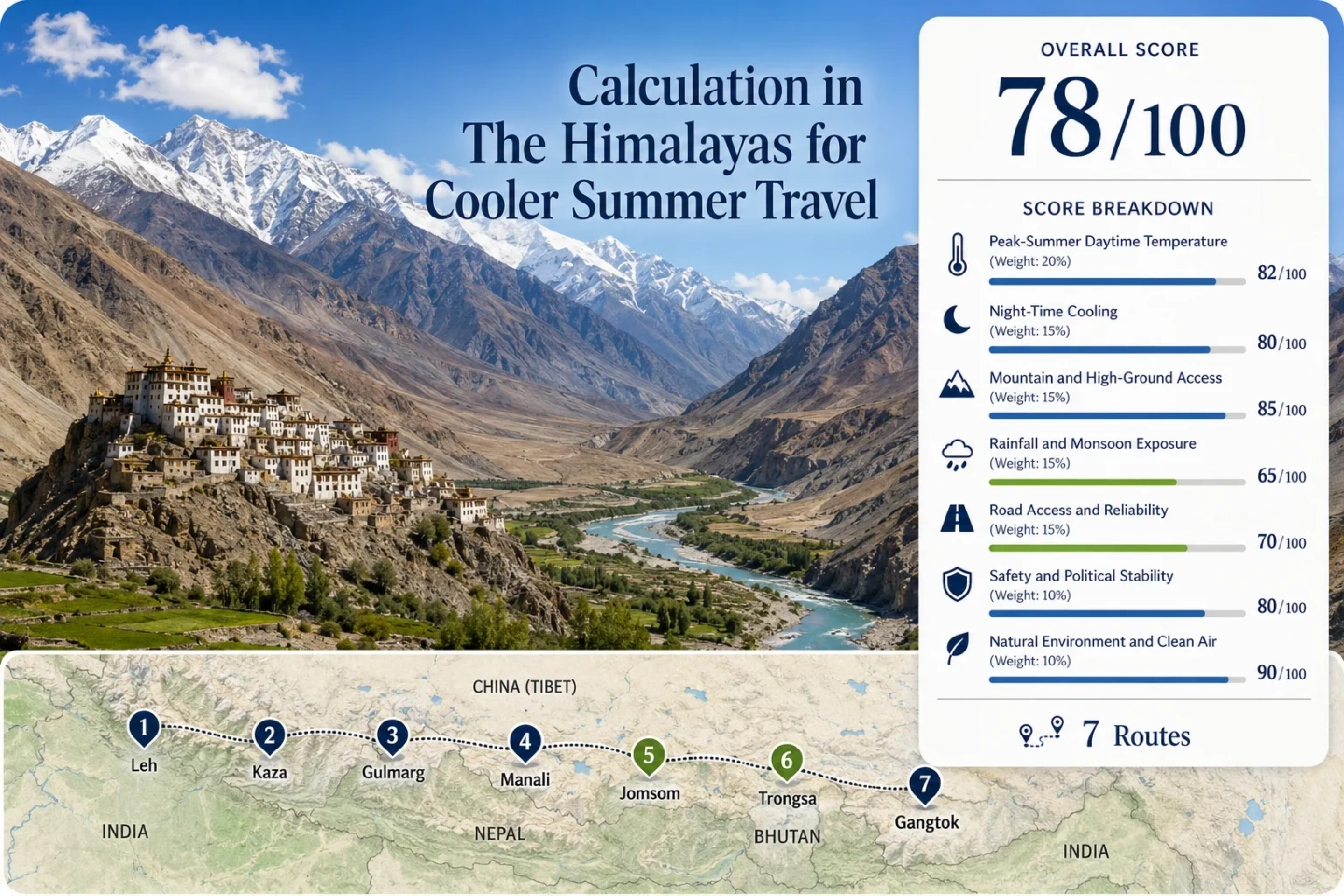
The Himalayas for Cooler Summer Travel
July and August can bring major relief from South Asia’s lowland heat, but the Himalayas do not share one summer climate. Ladakh, Spiti and Mustang lie in rain-shadow interiors, while Manali and Gangtok receive much more monsoon moisture and cloud. Gulmarg and Bhutan’s central valleys occupy different middle positions. For summer cooling, the useful question is not simply how high a destination sits, but how elevation, monsoon exposure, road reliability and overnight altitude combine.
High inner valleys can remain comparatively dry while southern and eastern Himalayan slopes are cool, humid and frequently wet.
Spiti’s administrative center starts at an altitude where cool nights come with a real acclimatization and access trade-off.
The cooling advantage begins at the accommodation level rather than requiring a day trip to higher terrain.
Nepal Tourism Board climate information places annual rainfall in Mustang below 300 mm, compared with more than 3,000 mm in monsoon-exposed Pokhara.
Sikkim’s tourism authority identifies July as the wettest month in most places and records Gangtok at the wet end of the state’s rainy-day range.
A mountain town can have comfortable temperatures while persistent rain, fog, landslides or road delays reduce the value of the temperature advantage.
Seven Summer Bases Across the Himalayan Arc
These bases cover dry Trans-Himalayan valleys, western mountain resorts, a monsoon-facing Himachal town, Nepal’s Kali Gandaki rain shadow, Bhutan’s central highlands and the wet eastern Himalaya. Their differences matter more in July and August than a single regional temperature average.
Markers show planning centers for the selected summer bases, not exact viewpoints, legal parking points or trailheads. Local road conditions and access rules should be checked before travel.
Dry High Valleys, Monsoon Towns and Cooler Mountain Bases
The seven bases solve different summer problems. Some maximize dry high-altitude cooling; others reduce altitude exposure or provide easier transport while accepting more rain.
Leh: Dry High-Altitude Cooling in Ladakh
Leh starts at 3,524 m, so its summer cooling does not depend on commuting from a warm valley floor. Ladakh’s position north of the main monsoon barrier also produces a much drier peak-summer setting than the southern face of the Himalaya. Strong sunshine can make exposed afternoons feel warmer than the air temperature suggests, while dry air and elevation allow much stronger night cooling.
The town is reachable by air, while the long approaches from Srinagar and Manali are high-road journeys with seasonal limitations outside the main summer period.
Kaza: Spiti’s Higher and Drier Summer Base
Kaza sits at 3,660 m and is reached by road rather than by a nearby commercial airport. Himachal Tourism lists regular Manali–Kaza buses during the main summer road window from July to October and Shimla–Kinnaur services from May to October, with the road journey to Kaza taking roughly 12 hours from either gateway.
Its cold-desert terrain is the opposite of monsoon-green Manali. The high mountain barrier strips much of the moisture from air moving toward Spiti, making July and August useful months for travellers seeking cool conditions without the persistent rainfall found on the southern side of the range.
Gulmarg: Cooler Kashmir With Rapid Vertical Access
Gulmarg is about 60 km from Srinagar, with the Kashmir administration describing the road journey at roughly 1.5 hours by car. That makes it much less remote than Leh or Kaza while still placing visitors directly in a high mountain environment.
The gondola creates a wide vertical temperature range without requiring a 3,500 m overnight base: its first stage reaches about 2,600 m and the upper stage about 3,747 m. Kashmir receives more summer moisture than the Ladakh rain shadow, so Gulmarg trades some dry-weather reliability for easier access and lower overnight altitude exposure.
Manali: Cooler Than the Plains, Wetter Than Spiti
Manali has much easier transport than Spiti: Bhuntar airport is about 50 km away and regular road coaches connect the town with major northern Indian cities. Rohtang Pass is 51 km from Manali and provides access toward much higher terrain, although tourism vehicle access at the pass is regulated.
Manali makes more sense when road connectivity, town services, forests and easy day excursions matter more than dry skies. Travellers primarily seeking low humidity and clear peak-summer weather gain more from crossing toward Spiti.
Jomsom: Nepal’s Monsoon Rain-Shadow Option
Jomsom sits on the Kali Gandaki corridor in Mustang, where the Annapurna–Dhaulagiri barrier creates one of Nepal’s clearest rain shadows. Nepal Tourism Board climate information places annual rainfall in Mustang below 300 mm, while monsoon-exposed Pokhara exceeds 3,000 mm.
Jomsom can be reached by air from Pokhara and by land. Kagbeni, at 2,804 m, is accessible through Jomsom and marks the approach toward Upper Mustang. Continuing north of Kagbeni brings additional restricted-area permit requirements.
Dry does not mean calm. Mustang is exposed to strong valley winds, and mountain aviation can be sensitive to local weather. Jomsom is valuable in July and August because the rainfall pattern differs so sharply from much of Nepal, not because conditions are uniformly gentle.
Thimphu: A Temperate Bhutan Valley During the Summer Monsoon
Bhutan defines June through August as summer. Its climate changes sharply with elevation: the south is humid and subtropical, central Bhutan is temperate, and the high north is colder. The Indian monsoon generally runs from late June or July through late September and affects the southern regions most strongly.
Thimphu therefore offers a cooler central-valley base without the sleeping elevations of Leh or Kaza, but July and August still belong to Bhutan’s wetter period. Cloud, showers and road timing matter more than they do in Ladakh’s cold desert.
Gangtok: Eastern-Himalayan Cooling With Heavy Summer Rain
Gangtok demonstrates why temperature alone is a weak measure of Himalayan summer comfort. Sikkim receives heavy, widespread rainfall from May into early October, and the state tourism authority identifies July as the wettest month in most places. Its published rainy-day range runs from about 100 days at Thangu to as many as 184 at Gangtok.
The elevation still provides a clear thermal advantage over the hot lowlands, but the summer experience is humid, cloudy and frequently wet. Fog can obscure mountain views, while heavy rainfall can produce road blocks and transport delays.
Gangtok fits a traveller prioritizing lower temperatures, greenery and an established town base. It is a weak match for anyone treating July or August as a clear-sky Himalayan photography window.
Why Ladakh and Spiti Stay Drier While Manali and Gangtok Turn Wet
The Himalayan summer divide is created by topography as much as latitude. Moist monsoon air rises against the southern and eastern slopes, while some valleys behind major mountain barriers receive only a fraction of that moisture.
The Southern Slopes Intercept Monsoon Moisture
Moist air approaching the range is forced upward, cools and condenses over exposed slopes. Manali lies on this wetter side of the western Himalaya, while Sikkim’s position near Bay of Bengal moisture makes the eastern range particularly wet. Lower air temperatures can therefore coincide with high humidity, cloud and repeated rainfall.
For summer travel, that changes more than the view. Saturated slopes increase the importance of road-condition checks, and cloud can remove the high-mountain visibility that many travellers expect from cooler weather.
High Inner Valleys Sit Behind the Moisture Barrier
Ladakh, Spiti and Mustang occupy drier interiors beyond major Himalayan barriers. The difference is visible in their sparse vegetation, cold-desert terrain and much lower peak-summer rainfall burden.
This is why a dry July usually requires more than elevation alone. Travelling far enough into the rain shadow often means higher sleeping elevations, longer roads, high passes or restricted-area logistics. The drier weather is paired with greater access and altitude costs.
Kaza and Manali: One State, Two July Weather Regimes
Kaza and Manali are both in Himachal Pradesh, yet a state-level summer climate average hides the difference that matters to a heat-escape trip.
Manali Remains on the Wetter Side
Manali combines a forested valley, regular long-distance buses, nearby air access and a high-road connection toward Rohtang. Those features make arrival comparatively straightforward. July and August, however, coincide with Himachal’s monsoon road hazards, including slippery surfaces, landslides and rockfalls.
The result is accessible cooling with a rainfall penalty. It suits a town-based stay better than a trip built around consistently clear mountain panoramas.
Kaza Lies Beyond the Main Moisture Barrier
Kaza is higher, drier and far more dependent on mountain roads. The Manali approach operates across a relatively narrow summer window, while the Shimla–Kinnaur side provides a longer seasonal approach. Neither has the transport simplicity of reaching Manali.
The payoff is a July–August climate that behaves much more like an interior high-altitude desert. Manali reduces heat with elevation; Kaza combines elevation with rain-shadow geography.
Mustang Breaks Nepal’s Usual Monsoon Pattern
Nepal receives most of its annual precipitation during the June–September monsoon, but the national pattern changes north of the Annapurna mass. Nepal Tourism Board identifies both Manang and Mustang as rain-shadow areas and reports annual rainfall below 300 mm in Mustang, compared with about 3,345 mm in Pokhara.
That contrast makes Jomsom and the Kali Gandaki corridor unusually relevant to a July or August cooling trip. The same months that bring heavy rain to many Nepalese hill and trekking regions can remain relatively dry farther north. Upper Mustang extends the dry-weather advantage but adds restricted-area permits and more remote logistics.
South of the Barrier
Pokhara receives intense summer monsoon rainfall. It is useful as a transport gateway, but its peak-summer moisture pattern should not be transferred to Mustang.
Jomsom and the Kali Gandaki
Air and road access make Jomsom the practical transition into Mustang’s much drier interior. Wind and mountain transport variability remain part of the trade-off.
North of Kagbeni
The rain shadow becomes more pronounced toward Upper Mustang. Special access rules also begin north of Kagbeni, so cooler dry-weather value rises alongside planning friction.
When Extra Elevation Stops Being a Simple Cooling Advantage
Average air temperature generally falls with elevation, but a Himalayan summer base cannot be ranked by altitude alone. Cloud, sun exposure, valley shape, wind, humidity and the incoming air mass change real conditions, while very high sleeping elevations introduce acclimatization demands.
1,500–2,200 m
Useful town-level heat relief. Warm afternoons can still occur, but nights are generally cooler than the adjacent plains. Access and normal town services are often easier at this band than in the high interior.
2,200–3,000 m
Cooling becomes stronger without automatically turning the entire trip into a high-altitude itinerary. This band can work well where road access and accommodation are established.
3,000–3,800 m
Leh and Kaza sit within this high-altitude travel range. Cool nights become a major advantage, but acclimatization, sun exposure and the speed of ascent have to be treated as normal planning variables.
Above 3,800 m
Colder air is no longer an automatic improvement in summer comfort. Higher passes, lakes and trekking areas can be useful daytime destinations, yet sleeping higher increases altitude exposure and often reduces transport, medical and accommodation options.
Match the Base to the Summer Condition
July and August create the clearest separation between the dry inner Himalaya and the wetter southern and eastern slopes. The useful choice depends on whether dry weather, easier access, lower overnight altitude or green monsoon scenery carries more weight.
| Base | July–August Pattern | Cooling Advantage | Access Shape | Main Summer Limitation | Works For |
|---|---|---|---|---|---|
| Leh | Cool, dry high-altitude summer | 3,524 m overnight base and strong night cooling | Air access plus long seasonal highways | Acclimatization, strong sun and remote higher routes | Travellers prioritizing dry peak-summer weather |
| Kaza | Dry Trans-Himalayan summer | 3,660 m base plus pronounced rain shadow | Road-only; long approaches from Manali or Shimla | High sleeping altitude and seasonal road dependence | Cool, dry weather with low concern for easy access |
| Gulmarg | Cooler western-Himalayan summer with more moisture | Rapid gondola access to much higher terrain | About 60 km from Srinagar | More variable summer weather than Ladakh or Spiti | Lower overnight altitude with high-mountain day access |
| Manali | Cooler but monsoon-influenced | Mountain valley, forest cover and access toward Rohtang | Airport connection nearby and regular road coaches | Rain, landslides, rockfalls and traffic pressure | Town services and easier arrival over dry-sky reliability |
| Jomsom | Relatively dry despite Nepal’s monsoon | Mustang rain shadow and high Kali Gandaki valley | Air and road access through the Pokhara corridor | Wind, mountain transport variability and permits farther north | Nepal travel during peak monsoon with lower rainfall exposure |
| Thimphu | Mild central-highland summer with monsoon showers | Temperate valley climate without extreme sleeping altitude | Primarily road travel with hired vehicle and driver | Summer rainfall and slower mountain-road movement | Cooler valley travel combined with Bhutanese urban services |
| Gangtok | Cool, humid and very wet | Eastern-Himalayan elevation and persistent cloud cover | Established city base with road connections | July rainfall, fog, road blocks and reduced mountain visibility | Lower temperatures and green landscapes rather than dry weather |