Bulgaria Beyond the Beach: Mountain Resorts, Forest Trails and Cooler Towns
Bulgaria’s inland summer alternatives rise from the forested Balkan valleys to the high bases of Rila, Pirin and the Rhodopes. Mountain resorts such as Borovets and Pamporovo provide the lowest daytime heat, while Dospat, Koprivshtitsa, Velingrad and Tryavna add reservoir air, cooler nights, rail access and historic-town character.
The scoring set includes three high resorts, one reservoir town, two rail-linked mountain towns and two Balkan Range gateways.
Tryavna occupies the lower end, while Pamporovo places accommodation directly within a high Rhodope forest zone.
The disclosed July–August climate proxies are medians across the same eight destinations shown on the map.
High accommodation bases reduce afternoon heat before any additional ascent by lift, road or trail.
A high reservoir, conifer forest and cool night pattern create a different summer rhythm from Bulgaria’s spa and ski towns.
Rail access reaches all three, although mountain trailheads and outlying forest areas may still require local transport.
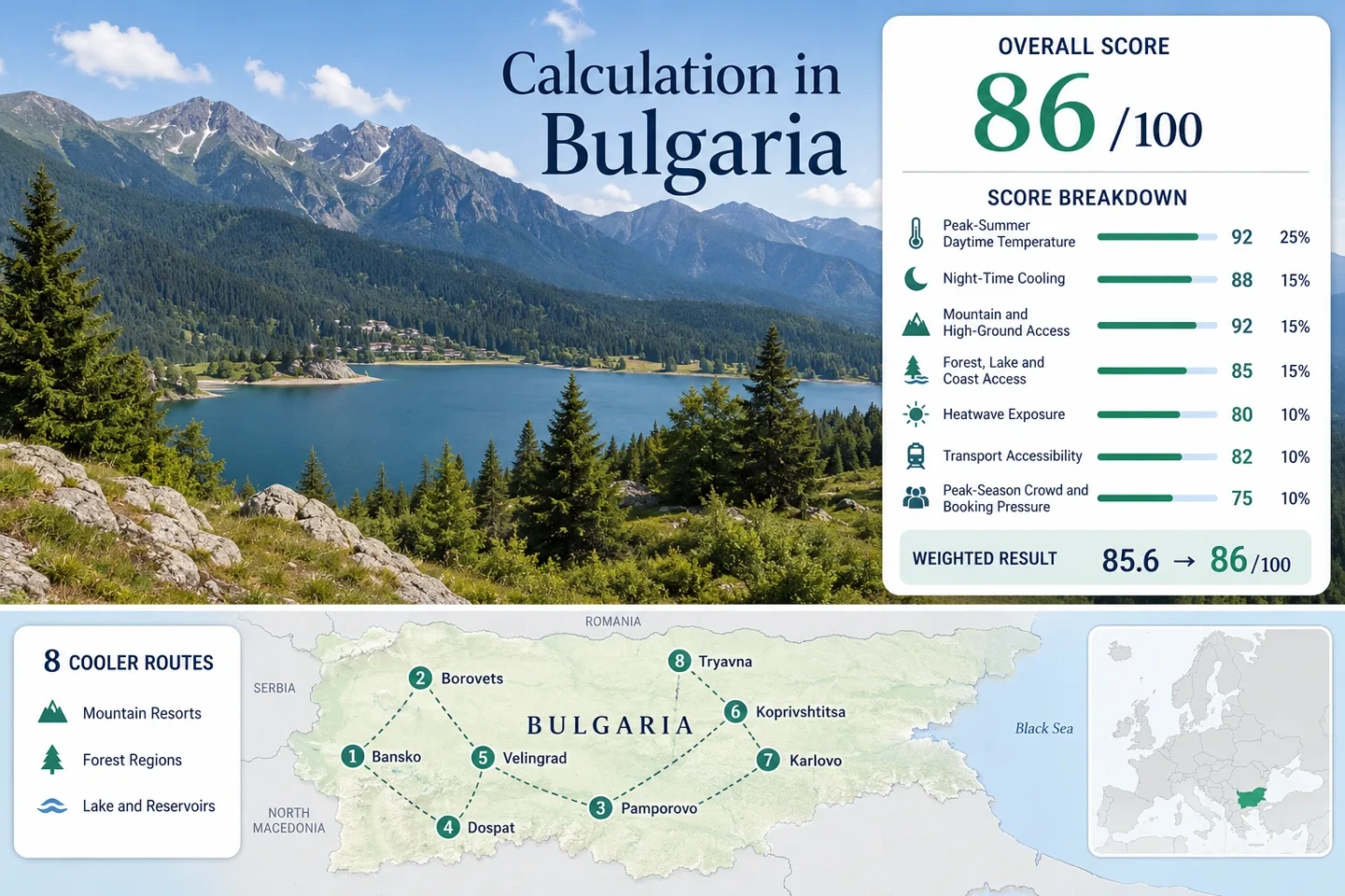
Bulgaria’s Inland Cool-Air Route Spine
The route set crosses Pirin, Rila, the Western and Central Rhodopes, Sredna Gora and the central Balkan Range. It deliberately avoids treating Bulgaria’s Black Sea coast as the country’s only summer-comfort option.
Markers show selected cooler-route regions and planning centers, not guaranteed legal parking, trailheads or exact viewpoints. Use each route card for Google Maps links and confirm current park, road and lift conditions before traveling.
Bulgaria Mountain and Forest Cooler Escape Suitability Score
This transparent editorial suitability index uses disclosed climate, landscape, access and pressure factors. It is not an official climate classification or a weather forecast.
High inland cooling suitability, driven by night-time relief, widespread high-ground access and a route portfolio that begins well above Bulgaria’s hottest plains.
Method: Median July–August average daily maximum across all eight routes, normalized with the fixed daytime-temperature scale.
Raw: Route-set median 24.05°C. Linear interpolation between 23°C = 90 and 25°C = 75 produces 82.1, rounded to 82.
Route values: Bansko 25.3°C; Borovets 20.0°C; Pamporovo 20.5°C; Dospat 22.8°C; Velingrad 25.3°C; Koprivshtitsa 22.8°C; Tryavna 26.4°C; Apriltsi 26.4°C.
Source mapping: Bansko, Dospat, Velingrad, Koprivshtitsa, Tryavna and Apriltsi use published location climatologies. Borovets uses lower-elevation Samokov as a representative reference with a transparent resort-elevation adjustment. Pamporovo uses lower-elevation Smolyan with the same approach.
Period: Published 1980–2016 station and MERRA-2-supported climatology. Values are planning proxies rather than current forecasts.
Sources: Bansko climatology; Samokov representative climatology; Smolyan representative climatology; Dospat climatology; Velingrad climatology; Koprivshtitsa climatology; Tryavna climatology; Apriltsi climatology; NASA MERRA-2 overview.
Method: Median July–August average daily minimum across the same eight routes.
Raw: Route-set median 11.25°C, within the fixed 10–16°C full-score band.
Route values: Bansko 12.5°C; Borovets 9.0°C; Pamporovo 10.0°C; Dospat 10.0°C; Velingrad 12.5°C; Koprivshtitsa 9.5°C; Tryavna 13.0°C; Apriltsi 13.0°C.
Source mapping: Direct published location climatologies were used where available. The Borovets and Pamporovo values account for the substantial elevation difference from the cited representative towns.
Period: Published 1980–2016 climatology, evaluated for July and August.
Sources: Bansko summer profile; Samokov summer profile; Smolyan August profile; Dospat climatology; Velingrad summer profile; Koprivshtitsa climatology; Tryavna climatology; Apriltsi climatology.
Method: Fixed accommodation-elevation and one-hour high-ground-access rubric, scored route by route before taking the median.
Raw: Median categorical score 100.
Route scores: Bansko 100 — accommodation near 925 m with Pirin trail access above 1,500 m; Borovets 100 — resort base near 1,300 m; Pamporovo 100 — accommodation near 1,620 m; Dospat 100 — high Rhodope base near 1,350 m; Velingrad 80 — base around 750–850 m with Western Rhodope high ground nearby; Koprivshtitsa 100 — town near 1,060 m; Tryavna 60 — lower town with meaningful Balkan foothill access; Apriltsi 80 — foothill base with Central Balkan trailheads.
Route rationale: Five of the eight accommodation bases already meet or exceed the 900 m full-score threshold. The remaining routes retain practical access to higher forest or park terrain.
Period: Elevation and access configuration reviewed 15 July 2026.
Sources: Pirin summer access information; Borovets hiking access; Pamporovo summer operations; Dospat municipal profile; Koprivshtitsa destination record; Central Balkan visitor information.
Method: Fixed access rubric measuring whether substantial forest, lake, river or coast environments can be reached within 30 or 60 minutes.
Raw: Median categorical score 75.
Route scores: Bansko 75 — immediate Pirin forest access; Borovets 75 — direct Rila forest access; Pamporovo 100 — spruce forest and the Smolyan Lakes area; Dospat 100 — reservoir and extensive conifer forest; Velingrad 75 — Western Rhodope forest access; Koprivshtitsa 75 — Sredna Gora forest belt; Tryavna 75 — Bulgarka forest routes; Apriltsi 100 — Central Balkan forests and mountain river valleys.
Route rationale: Every route reaches at least one strong cooling landscape within the primary 30-minute access band. Three routes combine water and extensive forest.
Period: Current physical access and official visitor information reviewed 15 July 2026.
Sources: Rila forest routes; Central Rhodope forest context; Dospat reservoir and protected areas; Velingrad forest routes; Tryavna visitor information; Central Balkan National Park.
Method: Proxy Dataset calculation using published modeled temperature-distribution bands. The route bands were converted to disclosed midpoints solely for normalization; they are not presented as exact observed daily counts.
Raw: Median midpoint 2.5% of July–August days at or above 30°C. Interpolation between 2% = 90 and 5% = 75 produces 87.5, rounded to 88.
Route values: Borovets below 1% midpoint 0.5%; Pamporovo below 1% midpoint 0.5%; Dospat 1–2% midpoint 1.5%; Koprivshtitsa 1–2% midpoint 1.5%; Bansko 2–5% midpoint 3.5%; Velingrad 2–5% midpoint 3.5%; Tryavna 5–10% midpoint 7.5%; Apriltsi 5–10% midpoint 7.5%.
Dataset details: Temperature units are degrees Celsius. Route or representative-center coordinates correspond to the mapped destinations. Published climatology uses station information corrected with MERRA-2 spatial relationships. No incomplete “0/N days” series is treated as an exact daily count.
Period: 1980–2016 published climatological distributions. A harmonized route-level daily series for the latest ten completed summers was not available for every selected base, which is reflected in comparability class C.
Sources: Bansko distribution bands; Samokov representative bands; Smolyan representative bands; Dospat distribution bands; Velingrad distribution bands; NASA MERRA-2 dataset context.
Method: Fixed public-transport and driving-complexity rubric, scored for reaching the accommodation base rather than every remote trailhead.
Raw: Median categorical score 80.
Route scores: Bansko 100 — narrow-gauge rail and scheduled bus access; Borovets 80 — Sofia-to-Samokov corridor with onward resort buses; Pamporovo 60 — public transport reaches the wider area but local mobility is easier by car; Dospat 40 — limited mountain-road public transport; Velingrad 100 — narrow-gauge rail and bus access; Koprivshtitsa 80 — mainline station outside town with onward transfer; Tryavna 100 — direct rail access; Apriltsi 40 — bus connections exist but trailhead mobility is substantially easier by car.
Route rationale: The portfolio contains three strong rail bases, one rail-linked town requiring a station transfer and four routes where buses or private vehicles remain more practical.
Period: Network structure and published schedules reviewed 15 July 2026. Exact departure times remain date-specific.
Sources: BDZ passenger timetable; Borovets resort access information; Pamporovo visitor information; Koprivshtitsa transport context; Tryavna visitor information; Apriltsi park office information.
Method: Categorical pressure rubric using official accommodation context, resort operating calendars, event exposure, spa demand and limited trailhead or lakeside capacity.
Raw: Median categorical score 60.
Route scores: Bansko 60 — substantial room supply but concentrated summer events and trailhead demand; Borovets 60 — weekend and lift-calendar concentration; Pamporovo 60 — resort events and lift-served activity peaks; Dospat 80 — lower overall pressure with localized reservoir-weekend demand; Velingrad 60 — spa-weekend booking pressure; Koprivshtitsa 60 — heritage weekends and event-sensitive demand; Tryavna 60 — historic-center weekend concentration; Apriltsi 80 — dispersed accommodation with localized park-access pressure.
Route rationale: None of the routes receives a severe-capacity score, but six require earlier planning for selected weekends, spa properties, lift days or major events.
Period: Official 2023–2025 accommodation context and summer 2026 operating information. Comparable route-level occupancy was not published for every municipality.
Sources: Bulgarian NSI hotel occupancy data; August 2025 accommodation release; Borovets summer 2026 operations; Pamporovo summer 2026 opening; Bulgarian tourist information centers.
Weighted calculation:
82×0.25 + 100×0.20 + 100×0.15 + 75×0.15 + 88×0.10 + 80×0.10 + 60×0.05 = 86.55
Rounded overall score: 87/100
Mountain Resorts, Reservoir Forests and Historic Highland Towns
The route portfolio separates true high-resort bases from lower historic towns where forest shade and night cooling matter more than afternoon temperature. Each destination has a different relationship with rail access, lift service, reservoir air or national-park trailheads.
Bansko & Pirin National Park
Bansko combines a functioning town, substantial accommodation supply and direct entry into the northern Pirin landscape. The town itself can still become warm during clear July afternoons, but the average night proxy remains close to 12.5°C and higher trail sectors provide a rapid temperature contrast.
Road access toward Vihren Hut reaches roughly 1,950 m, while Pirin routes continue through conifer forest, glacial basins and exposed alpine terrain. Trailhead capacity matters: A cool mountain forecast does not guarantee unrestricted parking or road access.
Borovets & Rila
The accommodation base begins near 1,300 m, placing Borovets well above Samokov and the Sofia basin before any lift or trail ascent. The route proxy uses a July–August daytime value near 20°C and a night value near 9°C after accounting for the resort’s elevation.
Marked walks, mountain-bike routes and lift-assisted access expand the usable altitude range. Operating days can differ between the gondola and chairlift, and strong wind, lightning or maintenance can interrupt service.
Pamporovo & Smolyan Lakes
Pamporovo has the highest accommodation base in the route set. The resort sits directly within the central Rhodope forest belt, so cooling does not depend on a long transfer from a lower valley town.
The Snezhanka area adds higher viewpoints and managed summer activities, while Smolyan Lakes introduces a water-and-forest alternative within the wider resort zone. Public transport reaches the region, but a car makes it easier to combine the resort, Chepelare, Smolyan and separate trail sectors.
Dospat & Reservoir Forests
Dospat occupies a high Western Rhodope plateau near 1,350 m. Its modeled July–August profile is approximately 22.8°C by day and 10°C at night, creating a strong combination of daytime moderation and sleep-friendly evening temperatures.
The large reservoir creates open water exposure, while surrounding spruce and pine forests provide shaded walking options. Accommodation is dispersed between town, reservoir edges and nearby settlements, so driving distances and road condition matter more than they do in compact resort centers.
Velingrad & Western Rhodopes
Velingrad is warmer than Dospat or Pamporovo during peak afternoon hours, but it combines cool nights, wooded slopes, mineral-water facilities and unusually useful rail access for a Bulgarian mountain destination.
The narrow-gauge line provides a scenic car-light approach from Septemvri, while forest areas and higher Western Rhodope roads extend beyond the urban base. Spa demand can tighten weekend availability even when hiking pressure remains moderate.
Koprivshtitsa & Sredna Gora
Approximate base elevation: 1,060 m. July–August proxy: 22.8°C daytime and 9.5°C at night. Access: Mainline rail reaches Koprivshtitsa station outside the town, followed by a local road transfer.
The high valley setting gives the historic center a cooler night profile than Sofia or Plovdiv, while forested Sredna Gora ridges begin close to town. Cobblestone streets and museum hours make the route as much a town stay as a hiking base.
Tryavna & Bulgarka Nature Park
Tryavna’s base near 440 m is much lower than the Rhodope and Rila resorts. Its approximate 26.4°C July–August daytime proxy means the town should not be treated as a guaranteed cool zone during a national heat event.
The cooling advantage comes from night relief, wooded Balkan foothills and the ability to shift daytime activity toward forest routes. Direct rail access makes Tryavna one of the simplest inland options for travelers avoiding a rental car.
Apriltsi & Central Balkan National Park
Apriltsi spreads across several neighborhoods beneath the high central Balkan ridge. The settlement can become warm in direct afternoon sun, but mountain rivers, wooded approaches and rapid elevation gain provide multiple ways to move out of the valley heat.
The absence of a lift-centered resort system changes the planning logic: trailhead selection, park rules, road access and walking distance matter more than purchasing a lift ticket. Accommodation is dispersed, making location choice important for early starts.
Rila, Pirin and Rhodope Altitude Bands
Bulgaria’s mountain systems do not produce one uniform summer climate. The practical difference begins with where the bed is located, then continues with how easily the route gains another 500–1,000 m during the day.
Rila: High Resort Accommodation
Borovets begins near 1,300 m and can reach higher terrain through lift-assisted and walking routes. The main benefit is immediate: cooler air is present around the accommodation base rather than only after a morning drive.
Trade-off: Access to selected upper sectors is tied to lift calendars, weather holds and operating-day differences.
Pirin: Town Services Below Alpine Terrain
Bansko sits lower than Borovets but provides a broader town infrastructure. The route gains altitude through the national-park road, mountain huts and long alpine trails rather than keeping every visitor inside a compact high resort.
Trade-off: The town may be warm at midday even when upper Pirin conditions remain cool or stormy.
Rhodopes: Plateau Towns and Continuous Forest
Pamporovo and Dospat place accommodation above roughly 1,300 m, while Velingrad occupies a lower, service-rich basin. The Rhodope advantage is not only elevation; long forest belts provide shade between towns, reservoirs and trail areas.
Trade-off: The strongest forest-and-water combinations are easier to connect by car than by frequent local public transport.
Rail-Linked Towns and Road-Dependent Forest Bases
The comparison uses the identical eight-route set assessed by the map and score. Climate figures are planning proxies, while access descriptions refer to reaching the accommodation base rather than every remote path or viewpoint.
| Route | Approximate base elevation | July–August day / night proxy | Car-light potential | Primary cooling mechanism | Main constraint |
|---|---|---|---|---|---|
| Bansko & Pirin National Park | About 925 m | 25.3°C / 12.5°C | Strong for the town; local transfer needed for some trailheads | Cool nights plus rapid ascent into Pirin | Trailhead road and parking pressure |
| Borovets & Rila | About 1,300 m | 20.0°C / 9.0°C | Moderate via Sofia and Samokov buses | High accommodation base and lift-assisted altitude | Lift schedules and weather suspensions |
| Pamporovo & Smolyan Lakes | About 1,620 m | 20.5°C / 10.0°C | Moderate; car improves regional combinations | High forest base with nearby lakes | Dispersed attractions and storm-sensitive lifts |
| Dospat & Reservoir Forests | About 1,350 m | 22.8°C / 10.0°C | Limited | Reservoir exposure, conifer shade and high plateau nights | Mountain-road dependence |
| Velingrad & Western Rhodopes | About 750–850 m | 25.3°C / 12.5°C | Strong for town and spa stays | Night cooling, wooded slopes and higher-road options | Weekend spa demand |
| Koprivshtitsa & Sredna Gora | About 1,060 m | 22.8°C / 9.5°C | Moderate; station transfer required | High valley nights and nearby forest ridges | Small-town event capacity |
| Tryavna & Bulgarka Nature Park | About 440 m | 26.4°C / 13.0°C | Strong | Rail access, night relief and forest-day alternatives | Warmer valley afternoons |
| Apriltsi & Central Balkan National Park | About 500–600 m | 26.4°C / 13.0°C | Limited to moderate | Rapid ascent, wooded valleys and mountain rivers | Dispersed neighborhoods and trailheads |
Lift Calendars, Trailheads and Park Rules
A Bulgarian winter-resort name does not guarantee that every lift runs daily in summer. National-park routes also involve a different access system from managed bike parks and sightseeing lifts.
Borovets Uses Separate Lift Calendars
The Yastrebets gondola and Sitnyakovo chairlift can follow different operating days and hours. Some hiking products depend on a specific lift, while lower forest routes remain possible without reaching the upper station.
Planning effect: Match the intended trail to the named lift rather than assuming the entire resort system is operating.
Pamporovo Operations Remain Weather-Sensitive
The summer zone around Snezhanka supports walking and cycling access, but strong wind, heavy rain and lightning can interrupt exposed facilities. Smolyan Lakes and lower forest walks provide alternatives when upper access pauses.
Bansko’s Trailhead Road Is Separate From Town Access
Reaching Bansko by train or bus does not automatically solve transport to Vihren Hut or other Pirin starting points. Seasonal traffic controls, parking limits and local transfer arrangements can determine the practical start time.
Apriltsi Relies on Multiple Park Approaches
Apriltsi is not a single compact trailhead. Different neighborhoods lead toward different valleys, huts and Central Balkan routes, so accommodation location can remove or add a substantial morning road transfer.
From Early-July Trails to Late-August Town Stays
The useful window changes according to altitude, lift operations, storm exposure and whether the priority is long hiking days, lower heat or quieter historic-town accommodation.
Early July
Strongest use: Forest trails, reservoir stays and lower-to-middle mountain routes.
Long daylight supports early starts and flexible route changes. Upper Pirin and Rila terrain may still hold isolated snow or wet sections, while afternoon thunderstorms remain a meaningful planning factor.
Mid-July to Mid-August
Lowest-heat emphasis: Borovets, Pamporovo and Dospat.
These high bases provide the clearest contrast with Sofia, Plovdiv and Bulgaria’s lower inland valleys. Weekend demand rises around lift operations, festivals, spa properties and accessible reservoir areas.
Late August to Mid-September
Balanced town window: Koprivshtitsa, Tryavna, Velingrad and Bansko.
Nights cool first, while daytime conditions often remain suitable for town walks and lower forest routes. Some summer lift calendars begin to narrow, making rail-linked towns more dependable than lift-dependent itineraries.
When Sofia and Plovdiv Heat Pushes Inland
Not every mountain-labeled town remains cool during a regional heat event. The practical response is to change altitude, shade and daily timing rather than relying on the destination name alone.
Move Up From Lower Towns
When Tryavna or Apriltsi forecasts approach 30°C, shift the main activity toward Bulgarka forest sectors, Central Balkan trailheads or a higher overnight base. Their valley locations retain better night relief than plains, but afternoons can still become hot.
Use Rhodope Water and Forest Together
Dospat offers open reservoir air beside dense conifer zones. Alternate exposed shore time with shaded forest sections, because water access alone does not remove strong midday sun at roughly 1,350 m.
Sleep at the Higher Base
Borovets and Pamporovo reduce the need for a daily ascent from a warm valley. This becomes especially valuable during multi-day heat alerts, when returning each evening to a high accommodation base preserves the night-cooling advantage.
Mountain-weather check: Confirm current Bulgarian weather warnings, lightning risk, park restrictions, road conditions and lift operations on the day of travel. A lower-valley heat warning can coincide with fog, strong wind or thunderstorms on exposed ridges.