Greece Heat Escape Routes: Mountain Villages, Northern Regions and Island Breezes
Greece can remain intensely hot in July and August, yet elevation, northern latitude, forest cover and exposed Aegean air create useful alternatives to lowland city heat. The strongest relief comes from sleeping above 1,000 metres in Epirus or Western Macedonia; Pelion and the islands add wind and water access rather than consistently low daytime temperatures. No route guarantees cool weather during a regional heatwave, so altitude, shade, overnight lows and transport reliability matter more than a coastal label alone.
Four high northern villages, two mountain-to-sea slopes and two wind-exposed island bases form the same set used by the map, score and comparison matrix.
Its elevation and surrounding beech forest give the route set its clearest combination of cooler afternoons and strong night-time relief.
The trade-off is access: a car is far more useful here than in Metsovo, Tsagarada or Apeiranthos.
Metsovo, Monodendri, Nymfaio and Agios Germanos retain the widest expected gap between sunny afternoons and cooler sleeping hours.
Scheduled coaches or buses exist, but late services, ferry connections and onward village mobility still require timetable checks.
Wildfire restrictions, strong winds, port orders and mountain-road delays can alter a route even when the destination itself remains open.
From the Pindus Villages to the North Aegean
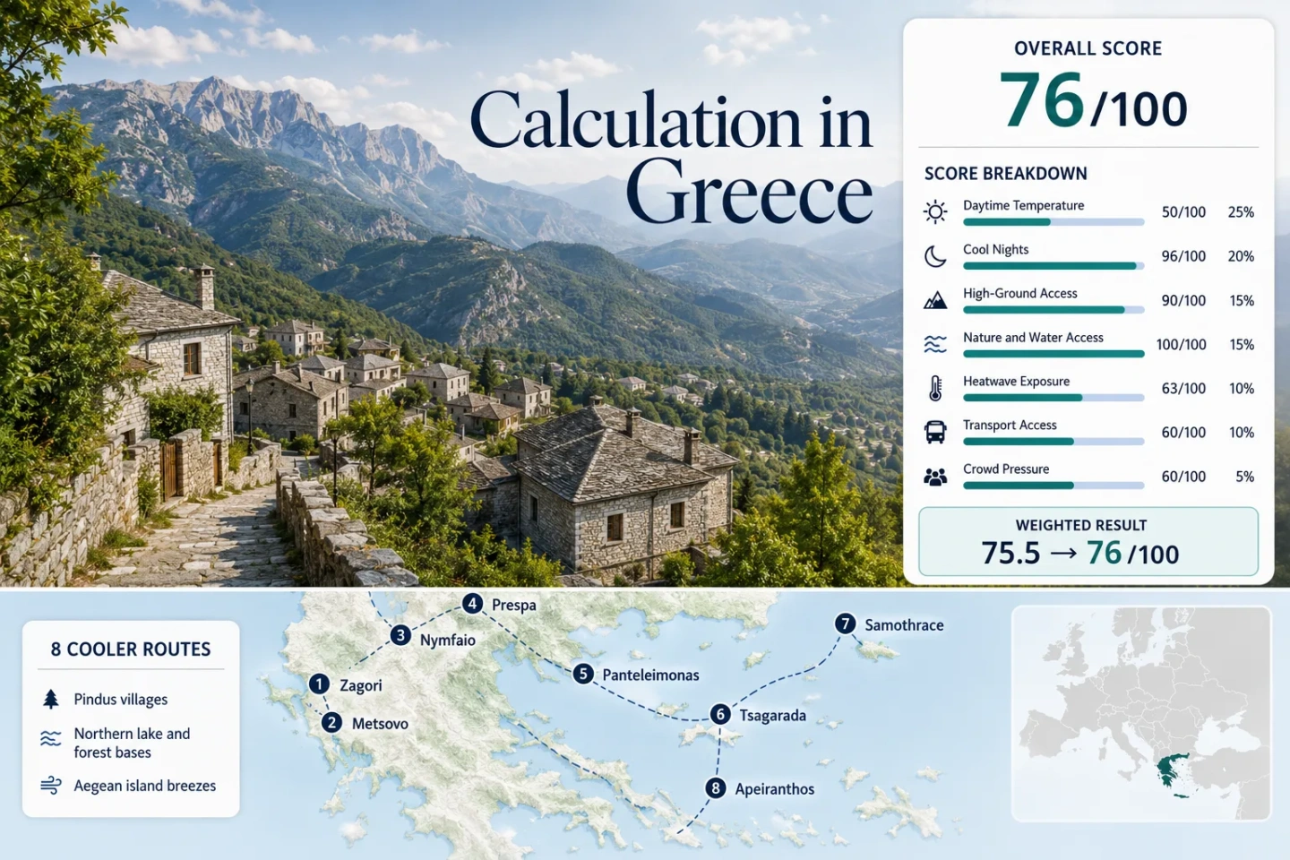
The markers connect high settlements in Epirus and Western Macedonia with Olympus and Pelion slopes, then extend to Samothrace and inland Naxos. The numbered sequence matches the destination portfolio that follows the score.
This marker map is built for planning orientation. Marker positions use approximate public location centres where exact viewpoints, trailheads, legal parking areas or pull-offs are not specified. Markers show selected cooler-route regions and planning centres, not guaranteed legal parking, trailheads or exact viewpoints. Use each route card for Google Maps links and access notes before travelling.
Greece Mountain and Island Cooler Escape Suitability Score
This is a transparent editorial suitability index based on disclosed climate, landscape, access and pressure factors. It is not an official climate classification or a weather forecast. The score represents the eight named routes rather than the average conditions across Greece, and route count does not create a scoring bonus.
Method: Proxy Dataset aggregation. Rounded July–August daily maximum temperature means were screened at each route centre using the ERA5-Land model family with terrain-adjusted location selection. The eight-route median of 27.6°C was normalised by the fixed daytime-temperature scale.
Raw: 27.6°C median; 27°C maps to 55 and 29°C maps to 35, giving 49.5 before factor rounding.
Route values: Monodendri 27.3°C; Metsovo 25.3°C; Nymfaio 24.0°C; Agios Germanos 27.6°C; Palaios Panteleimonas 28.2°C; Tsagarada 28.0°C; Samothrace Chora 29.0°C; Apeiranthos 27.5°C.
Source mapping: Route centres: Monodendri 39.884, 20.747; Metsovo 39.769, 21.182; Nymfaio 40.646, 21.496; Agios Germanos 40.839, 21.154; Palaios Panteleimonas 39.993, 22.576; Tsagarada 39.389, 23.171; Samothrace Chora 40.475, 25.523; Apeiranthos 37.071, 25.520. Variable: daily maximum 2 m air temperature in °C. Values are rounded route-centre screening estimates, not measurements at a lodging property.
Period: July and August across 1991–2020.
Sources: Open-Meteo Historical Weather API documentation; Copernicus ERA5-Land daily statistics; HNMS climate data context.
Method: Proxy Dataset aggregation using the same route centres and baseline as the daytime factor. The median July–August daily minimum was 16.5°C, measuring overnight relief rather than the coldest isolated night.
Raw: 16.5°C median; the fixed scale gives 100 at 16°C and 85 at 18°C, producing 96.3 before factor rounding.
Route values: Monodendri 14.5°C; Metsovo 12.8°C; Nymfaio 12.0°C; Agios Germanos 14.0°C; Palaios Panteleimonas 18.5°C; Tsagarada 19.0°C; Samothrace Chora 20.0°C; Apeiranthos 20.0°C.
Source mapping: Variable: daily minimum 2 m air temperature in °C at the eight route-centre coordinates listed in the daytime factor. Island and coastal minima can vary materially between an exposed ridge, a sheltered lane and a waterfront room.
Period: July and August across 1991–2020.
Sources: Open-Meteo historical reanalysis specification; Copernicus ERA5-Land time-series product; CLIMADAT-GRid Greece dataset context.
Method: Fixed categorical rubric applied to accommodation-base elevation and practical access to higher ground within about 60 minutes. The median of the eight route scores is 90.
Raw: Median category score 90/100.
Route scores: Monodendri 100 — sleeping base around 1,060 m; Metsovo 100 — base around 1,160 m; Nymfaio 100 — documented 1,350 m; Agios Germanos 100 — Prespa village base around 1,040 m; Palaios Panteleimonas 80 — 500 m base with Olympus high ground within the route; Tsagarada 80 — approximately 450 m with higher Pelion access; Samothrace Chora 80 — lower base but Mount Saos rises to 1,611 m; Apeiranthos 80 — approximately 650 m on inland Naxos.
Route rationale: The first four routes deliver altitude at the sleeping base. The final four need either a higher excursion, an exposed ridge or a mountain-road climb to turn scenery into measurable daytime relief.
Period: Access and published elevation information reviewed July 15, 2026.
Sources: Visit Greece: Nymfaio; Visit Greece: northern and mountain villages; Fast Ferries: Samothrace geography; Naxos Public Buses: Apeiranthos route.
Method: Fixed access rubric measuring whether broad forest, a major lake or river system, or the sea can be reached within approximately 30 minutes. Scenic quality is not scored. The route median is 100.
Raw: Median category score 100/100.
Route scores: Monodendri 100 — Zagori forest and Vikos–Voidomatis water system; Metsovo 100 — Pindus forest and Aoos Springs Lake area; Nymfaio 100 — beech forest plus nearby Western Macedonia lakes; Agios Germanos 100 — Prespa lakes and mountain woodland; Palaios Panteleimonas 100 — Olympus forest and Thermaic coast; Tsagarada 100 — chestnut and beech slopes with Aegean beaches; Samothrace Chora 100 — mountain woodland, streams and coast; Apeiranthos 75 — strong coast access but less continuous broad forest near the base.
Route rationale: Water or vegetation provides shade, swimming or evaporative relief, but it does not automatically lower midday air temperature. The score records physical access only.
Period: Route geography and access reviewed July 15, 2026.
Sources: Visit Greece: Nymfaio beech forest; Visit Greece: Prespa and Pelion villages; Fast Ferries: Samothrace forest, water and coast; Naxos Public Buses: inland Naxos route.
Method: Proxy Dataset screening estimate. Route-centre July–August daily maximum series were assessed against the 30°C threshold using the ERA5-Land model family. Percentages are rounded planning proxies and should not be read as audited station exceedance counts.
Raw: Median proxy share 8.0%; the fixed heatwave scale gives 75 at 5% and 55 at 10%, producing 63/100.
Route values: Monodendri 6.8%; Metsovo 3.9%; Nymfaio 2.1%; Agios Germanos 7.4%; Palaios Panteleimonas 12.9%; Tsagarada 11.6%; Samothrace Chora 9.8%; Apeiranthos 8.6%.
Coverage: Screening window specification: 620 July–August calendar days per route across ten completed summers. Model availability is gap-filled by design; local station observations may diverge in complex terrain.
Period: July 1–August 31 for 2016–2025.
Sources: Open-Meteo ERA5-Land query specification; Copernicus daily maximum temperature definition; HNMS climate data reference.
Method: Fixed categorical transport rubric based on the current public-transport chain, ferry dependence, final-road complexity and whether a private car remains practically necessary. The median route score is 60.
Raw: Median category score 60/100.
Route scores: Monodendri 40 — Ioannina gateway with limited onward service and car-dependent village movement; Metsovo 80 — intercity coach access on a major corridor; Nymfaio 60 — straightforward road transfer but a car is strongly preferred; Agios Germanos 60 — Florina gateway with limited local frequency; Palaios Panteleimonas 60 — coastal rail or coach access followed by a local road transfer; Tsagarada 60 — scheduled Pelion buses but winding roads and limited late service; Samothrace Chora 20 — ferry plus island transfer; Apeiranthos 20 — ferry to Naxos followed by an approximately one-hour island bus.
Route rationale: Ferry availability improves in peak summer, yet port orders and wind can disrupt the full chain. Mainland mountain routes avoid ferry risk but often lose flexibility after the last local bus.
Period: Operator and route pages reviewed July 15, 2026.
Sources: KTEL Ioannina timetables; KTEL Volos routes and 2026 summer service notice; Naxos Public Buses: Apeiranthos; Fast Ferries 2026 route information.
Method: Fixed categorical pressure rubric used because comparable village-level July–August occupancy percentages are not published for all eight routes. Evidence considers ferry and bus capacity, compact village parking, accommodation concentration and documented regional tourism volume. No estimated occupancy percentage is inserted.
Raw: Median category score 60/100.
Route scores: Monodendri 60 — viewpoint and village-parking pressure without a universal reservation system; Metsovo 60 — busy weekend and transit-stop demand but a broader accommodation base; Nymfaio 80 — small inventory with lower mass-summer concentration; Agios Germanos 80 — limited rooms but lower island-style pressure; Palaios Panteleimonas 40 — compact parking and combined coast-village demand; Tsagarada 40 — narrow roads, beach parking and August pressure; Samothrace Chora 60 — ferry and vehicle capacity constrain arrivals; Apeiranthos 40 — Naxos ferry, road and bus pressure in August.
Route rationale: A small village can sell out without feeling crowded all day, while an island may have abundant beds but constrained ferries and roads. The factor therefore records booking and capacity pressure together.
Period: Latest complete national tourism context and 2026 operator capacity patterns available at the July 15, 2026 review.
Sources: Hellenic Statistical Authority: 2024 hotel arrivals and nights; Eurostat regional tourism context; Fast Ferries route capacity context; Naxos Public Buses peak-summer schedules.
Weighted total: 50×0.25 + 96×0.20 + 90×0.15 + 100×0.15 + 63×0.10 + 60×0.10 + 60×0.05 = 75.5 → 76/100
High Villages, Forest Slopes and Wind-Exposed Island Bases
The mainland routes lead on lower daytime heat and cooler sleeping hours. Pelion and the two island routes trade some temperature advantage for sea access, wind and easier combinations with a conventional Greek summer trip.
Monodendri and Central Zagori
Monodendri places the sleeping base above 1,000 metres, close to shaded stone lanes, Vikos viewpoints and the broader Zagori road network. The route-centre screening normal remains warm by alpine standards, but the expected night low is far below lowland Athens or Thessaloniki. The decisive advantage is the overnight reset, not a guarantee of cool midday hiking.
Ioannina is the practical gateway. Public transport can reach parts of Zagori, yet village-to-village movement and early trail starts are much easier by car. Exposed gorge walks need an early start, water and a storm check even when the village feels mild.
Metsovo
Metsovo combines a genuinely high sleeping base with a more usable transport position than most Greek mountain villages. Its location near the Egnatia corridor makes a short mountain stay possible without committing to a long chain of local roads. Nearby Pindus forest and the Aoos Springs Lake area add shaded drives and higher walking options.
The town can be busy on summer weekends, and sunny squares still become hot in the middle of the day. Even so, the projected night-time range is among the strongest in the portfolio. Morning walking and a shaded afternoon pause fit the local temperature rhythm better than continuous all-day sightseeing.
Nymfaio
Nymfaio is the highest accommodation base in the route set and the clearest choice when low heat takes priority over beach access. Visit Greece places the protected settlement at 1,350 metres on Mount Vitsi, surrounded by beech forest. The route-centre screening produces the lowest daytime and night-time values of the eight destinations.
That strength comes with a transport cost. A car is strongly preferred for the final approach and for combining the village with Florina, Amyntaio or nearby lakes. The small lodging stock also rewards early booking even though the settlement does not carry the same mass-summer pressure as a Cycladic island.
Agios Germanos and Prespa
Agios Germanos sits on the Varnountas slopes above the Prespa basin, pairing a high sleeping base with rapid access to lake scenery, woodland and borderland roads. The village is warmer by day than Nymfaio, but its projected nights remain favourable and the lake basin gives the itinerary a different pace from a steep Pindus route.
A private vehicle simplifies access from Florina and allows early movement before afternoon heat develops. Prespa is also a sensitive ecological landscape, so signed access rules, fire restrictions and protected-area instructions take priority over informal swimming or track suggestions.
Palaios Panteleimonas
This compact stone village occupies the lower Olympus foothills above the Pieria coast. Its base elevation moderates the night more than a beachfront stay, while the wider route can move between forested mountain roads and the Thermaic shore. The village itself is not high enough to deliver Pindus-level daytime relief.
The cooling depends on continuing upward when conditions allow. Mount Olympus access can bring a major temperature change, but higher trails introduce fog, storms, wind and seasonal refuge logistics. Parking pressure around the historic core and combined coast-village demand are the principal August constraints.
Tsagarada
Tsagarada lies in Pelion’s heavily vegetated eastern slope, where chestnut and beech cover, ravines and nearby Aegean beaches shape the daily comfort pattern. Shade can make village walking feel markedly easier than an exposed mainland town, but humidity and warm nights reduce the pure temperature advantage.
KTEL Volos publishes seasonal Pelion service, giving Tsagarada a stronger car-light case than many mountain villages. The road remains winding, late connections are limited and beach transfers may still favour a car. Rain, low cloud and fog are possible even while central Greece remains dry.
Samothrace Chora
Samothrace differs from a conventional beach-island escape. Chora sits below Mount Saos, while the island’s northern side combines forest, running water and steep relief. Sea wind can improve perceived comfort, but exposed afternoons still reach the upper end of the portfolio’s temperature range.
The ferry from Alexandroupoli is the defining access condition. Current operator information lists regular peak-season departures, yet port-authority orders and strong wind can change sailing times. Once on the island, limited buses and taxis make a vehicle useful for linking Chora, Therma and trail areas.
Apeiranthos
Apeiranthos sits on the inland Naxos mountain road at about 650 metres, high enough to separate it from the hotter port and beach strip. Stone lanes provide local shade, while northern summer winds can improve daytime comfort. Nights remain warmer than in the Pindus and Prespa villages.
Naxos Public Buses lists the route from Naxos Town through the central villages at roughly one hour. That gives Apeiranthos a credible car-light option after arrival by ferry, although the full journey still depends on port schedules and bus frequency. August road and ferry pressure can be substantial.
Pindus and Prespa Nights Versus Aegean Wind
The routes divide into two cooling systems that should not be treated as interchangeable. Mountain villages reduce the temperature itself, especially after sunset. Island and coastal slopes often improve how heat feels through wind, shade and water access while keeping warmer nights.
Sleep High in the North
Nymfaio, Metsovo, Monodendri and Agios Germanos place accommodation near or above 1,000 metres. Their route-centre night proxies range from 12.0°C to 14.5°C, creating the most reliable overnight recovery in the portfolio. The price is road dependence and less immediate swimming access.
Use Pelion’s Forest Canopy
Tsagarada’s advantage is not a dramatic temperature score. Dense vegetation, shaded lanes and quick movement between mountain and sea change exposure through the day. Humidity and a 19.0°C screening night low mean ventilation still matters when choosing a room.
Treat Island Wind as Conditional
Samothrace and Apeiranthos can feel easier when northerly winds are active, yet calm periods remove much of that benefit. A shaded inland room with cross-ventilation is more dependable than assuming every island night will be cool.
When the Cooling Depends on an Ascent
Palaios Panteleimonas and Tsagarada illustrate a common Greek mountain-coast trap: a scenic slope village is not automatically a high-altitude refuge. Both bases sit below 600 metres. Their strongest temperature advantage appears when the day continues toward higher Olympus or Pelion ground, not when it remains in a sunny square or descends to the beach at noon.
Olympus Changes Fast
Higher Olympus terrain can be much cooler than the Pieria coast, but sudden fog, wind and storms change the risk profile. Snow-free access, refuge operation and a favourable forecast must all align; altitude should never be used as a reason to ignore mountain warnings.
Pelion Roads Set the Rhythm
Tsagarada’s forest shade is available at the village base, while greater relief requires climbing or crossing the peninsula’s winding road network. Travel time expands quickly, especially behind buses, service vehicles or summer beach traffic.
Check the Sleeping Altitude
A high excursion does not fix a warm room at night. For heat-sensitive travellers, the accommodation elevation and expected minimum temperature should be checked before attractive summit distances or sea views.
Eight Routes by Heat Window, Access and Main Trade-Off
The same eight destinations are compared without turning route quantity into a score advantage. Temperature figures are rounded route-centre screening proxies; access notes reflect the July 2026 review.
| Route | Sleeping Base | July–August Proxy High / Low | Lowest-Heat Use | Access Pattern | Main Trade-Off |
|---|---|---|---|---|---|
| Monodendri and Central Zagori | About 1,060 m | 27.3°C / 14.5°C | Early gorge viewpoints and cool nights | Ioannina gateway; car strongly useful | Limited onward buses and exposed trails |
| Metsovo | About 1,160 m | 25.3°C / 12.8°C | High-base town stay without a ferry | Intercity coach corridor | Weekend demand and sunny town squares |
| Nymfaio | 1,350 m | 24.0°C / 12.0°C | Lowest projected heat in the set | Road transfer; car preferred | Small lodging stock and winding approach |
| Agios Germanos and Prespa | About 1,040 m | 27.6°C / 14.0°C | High-base nights plus lake access | Florina gateway; limited local service | Protected-area rules and road dependence |
| Palaios Panteleimonas | About 500 m | 28.2°C / 18.5°C | Olympus ascent combined with swimming | Coastal rail or coach plus road transfer | Base is not high enough for strong midday relief |
| Tsagarada | About 450 m | 28.0°C / 19.0°C | Forest shade and Aegean beach pairing | Seasonal KTEL service from Volos | Humidity, winding roads and warm nights |
| Samothrace Chora | About 300 m | 29.0°C / 20.0°C | Wind, forest streams and higher excursions | Alexandroupoli ferry plus island transfer | Ferry disruption and exposed sunny periods |
| Apeiranthos | About 650 m | 27.5°C / 20.0°C | Higher inland sleeping base on Naxos | Ferry plus roughly one-hour public bus | August road pressure and warm nights |
Ferry Days and Winding Roads Change the Choice
Samothrace and Apeiranthos need a complete transport chain rather than a single ticket. A delayed ferry can remove the final bus, car-rental handover or evening check-in. Fast Ferries lists regular Samothrace departures in the 2026 peak period, while Naxos Public Buses publishes high-season village schedules. Both remain subject to operational changes, and a protected overnight buffer is sensible before an international flight.
The mainland routes remove port uncertainty but replace it with mountain-road timing. Zagori, Nymfaio, Prespa and Pelion all become slower after dark, during storms or behind summer traffic. Arrival before late afternoon is the safer pattern: it preserves daylight for the final road, allows a room-temperature check and avoids depending on the final local service.
Stronger Car-Light Chains
Metsovo offers the cleanest mainland coach case. Tsagarada can work with KTEL Volos when the seasonal timetable matches the stay. Apeiranthos has a defined public-bus route from Naxos Town, but only after the ferry arrival is secured.
Road-Dependent Bases
Nymfaio, Agios Germanos and Central Zagori are much more flexible with a car. Palaios Panteleimonas can be reached from the coast without one, yet meaningful Olympus access usually adds another transfer.
Late June and Early September Shift the Balance
A cooler itinerary does not need to use the same dates as a beach holiday. The useful window changes according to whether the priority is low heat, reliable ferry and bus service, swimming, or access to high trails.
Late June
Mountain villages often provide the strongest balance of long daylight and lower heat before peak Greek holiday pressure. High Olympus paths can still carry seasonal hazards, and the sea may feel cool for long swims. KTEL and ferry summer services should be checked because some expanded timetables begin near the end of June.
July and August
Transport frequency and swimming conditions are strongest, but so are heat, road pressure and booking demand. Nymfaio, Metsovo and the high Prespa or Zagori bases provide the clearest temperature defence. Island breeze should be treated as a bonus rather than a substitute for shade and ventilation.
Early September
Sea temperatures remain useful while nights begin to improve, making Pelion, Samothrace and inland Naxos more balanced. Some seasonal buses and ferries reduce frequency later in the month, so a quieter date can also create a weaker transport chain.