Romania for Heat Escape Travel: Carpathian Towns, Forest Roads and Mountain Air
Romania’s strongest summer heat-escape pattern follows a chain of Carpathian altitude bands rather than one uniformly cool region. Rail-accessible Prahova gateways, high park ridges, volcanic forest roads, reservoir valleys and resort bases above 1,400 metres provide very different levels of daytime relief. The route set separates cool upper-mountain conditions from hotter approach towns so that accommodation altitude, transfer time and night cooling remain part of the decision.
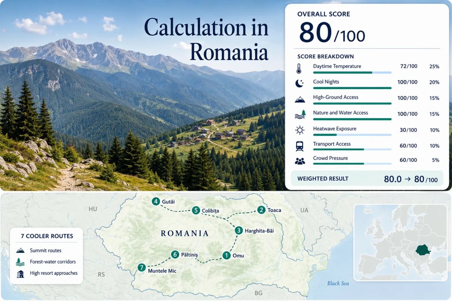
The same seven corridors appear in the map, score calculation, destination profiles and comparison matrix.
The 2,504-metre station recorded a 1991–2020 July–August mean daily maximum of about 10.0°C.
Accommodation around 1,450 metres reduces the need to descend into a hot gateway town each evening.
Tursib Route 22 provides a scheduled public-transport connection between the city and the Cindrel resort.
Neither high station recorded a 30°C day in its valid July–August observations from 2016 through 2025.
Some routes use summit climate stations, while Colibița, Păltiniș heat exposure and Muntele Mic require conservative lower-elevation gateway readings.
From Bucegi Ridges to Banat Mountain Roads
The markers connect two summit-oriented routes, three forest-and-water corridors and two high resort approaches across Romania’s main Carpathian arcs.
Markers show selected cooler-route regions and planning centres, not guaranteed legal parking, trailheads or exact viewpoints. Use each destination profile for Google Maps links and verify local access before travelling.
Romania Carpathian Heat-Escape Suitability Score
This transparent editorial suitability index uses disclosed climate, landscape, access and pressure factors. It is not an official climate classification or a weather forecast.
Weighted total: 72×0.25 + 100×0.20 + 100×0.15 + 100×0.15 + 30×0.10 + 60×0.10 + 60×0.05 = 80.0 → 80/100
Method: Route count does not add bonus points. Every route has equal weight, route-level values are combined through the median and the seven fixed factor weights remain unchanged.
Bucegi Summits, Volcanic Forests and Cool-Base Towns
The seven corridors range from exposed summit climates to mountain towns where cooler nights matter more than mild afternoons. Climate values identify the station used for comparison and should not be treated as a forecast for every point along the route.
Bușteni–Vârful Omu
The climate measurement comes from Vârful Omu at 2,504 metres, where the July–August 1991–2020 averages were about 10.0°C by day and 4.6°C by night. The daily record also contained no 30°C observations across 600 valid target-window days from 2016 through 2025.
Bușteni is reached directly by rail, but the measured summit conditions do not describe the lower town. Cable availability, wind, thunderstorms and hiking time determine how much of the day is actually spent in the cooler altitude band.
Durău–Ceahlău Toaca
Toaca station sits at 1,897 metres and produced July–August normals of approximately 15.2°C maximum and 7.9°C minimum. Its 2016–2025 daily series recorded 0 days at or above 30°C from 619 valid observations.
Durău functions as the park-side sleeping and trail base, while the coolest measurements belong to the high plateau. Reaching that climate requires a substantial ascent rather than a short urban transfer. Ceahlău forest and the nearby Izvorul Muntelui reservoir add lower-elevation alternatives when ridge weather closes in.
Miercurea Ciuc–Harghita-Băi
Miercurea Ciuc’s 661-metre station averaged about 25.3°C maximum and 9.3°C minimum in July–August. The daytime value is not exceptionally low, but the single-digit normal night temperature creates a clear overnight recovery advantage.
The daily heat record reached 30°C on 112 of 615 valid days, or 18.2%. Harghita-Băi lies higher, around the 1,300-metre band, and is reached through a forested road corridor. Staying at the resort rather than commuting from the city shifts more of the afternoon into the cooler elevation zone.
Ocna Șugatag–Gutâi Pass
Ocna Șugatag’s 503-metre climate point averaged 25.3°C maximum and 13.2°C minimum for July–August. The 2016–2025 record counted 110 days at or above 30°C from 617 valid observations, equivalent to 17.8%.
The temperature strategy depends on movement rather than one cold base: local salt-water use around Ocna Șugatag can be paired with the climb toward the 987-metre Gutâi Pass. The official destination description places the pass on a roughly 20-kilometre DN18 forest corridor, where shade, elevation and airflow change rapidly.
Bistrița–Colibița
The available long-period climate mapping uses Bistrița’s 366-metre gateway station: 27.3°C average maximum, 13.8°C average minimum and 234 days at or above 30°C from 613 valid July–August observations in 2016–2025.
Colibița lies approximately 35–40 kilometres east and at a substantially higher elevation than the station, so the gateway readings are intentionally conservative. The reservoir adds swimming potential and cooler nights, but it does not prevent hot afternoons during regional heat events.
Păltiniș–Cindrel
Păltiniș provides the strongest combination of a high sleeping base and scheduled public transport. Its 1,453-metre station averaged about 19.8°C maximum and 10.7°C minimum in July–August.
Heatwave exposure is conservatively represented by Sibiu, approximately 27 kilometres northeast and 1,009 metres lower. That station recorded 205 days at or above 30°C from 618 valid observations, a burden that is not expected to match the resort itself but does represent the transfer city.
Caransebeș–Muntele Mic
The comparison climate point is Caransebeș at 241 metres, where July–August normals reached 28.4°C maximum and 15.0°C minimum. Its daily record crossed 30°C on 309 of 619 valid days from 2016 through 2025.
Those figures describe the hot Banat gateway rather than the 1,545-metre Muntele Mic resort. The official destination profile places the mountain summit at 1,806 metres, creating one of the largest altitude gains in the route set. The road climb can therefore produce a substantial thermal change even when Caransebeș is under heat stress.
Why the Climate Point and the Sleeping Base Matter
Summit stations reveal the strength of the cool-air resource, while gateway stations reveal the heat encountered during arrival and transfer. The most practical route is not automatically the one with the lowest station temperature.
| Route | Climate point | July–August max/min | 30°C+ record | Car-light access | Main trade-off |
|---|---|---|---|---|---|
| Bușteni–Vârful Omu | Omu, 2,504 m | 10.0°C / 4.6°C | 0 of 600 valid days | Strong to Bușteni | Summit coolness requires cable or substantial hiking access |
| Durău–Ceahlău Toaca | Toaca, 1,897 m | 15.2°C / 7.9°C | 0 of 619 valid days | Limited | Coolest conditions sit well above the park gateway |
| Miercurea Ciuc–Harghita-Băi | Miercurea Ciuc, 661 m | 25.3°C / 9.3°C | 112 of 615 valid days | Rail plus transfer | Cool nights are stronger than daytime heat protection in town |
| Ocna Șugatag–Gutâi Pass | Ocna Șugatag, 503 m | 25.3°C / 13.2°C | 110 of 617 valid days | Moderate | Heat relief depends on driving the shaded pass corridor |
| Bistrița–Colibița | Bistrița, 366 m | 27.3°C / 13.8°C | 234 of 613 valid days | Rail to gateway | Gateway data are hotter and lower than the reservoir base |
| Păltiniș–Cindrel | Păltiniș, 1,453 m | 19.8°C / 10.7°C | 205 of 618 at lower Sibiu proxy | Scheduled bus | Limited departures require disciplined return timing |
| Caransebeș–Muntele Mic | Caransebeș, 241 m | 28.4°C / 15.0°C | 309 of 619 valid days | Rail to gateway | The largest altitude gain also carries strong car dependence |
Omu and Toaca Measure the Ridge, Not the Hotel Room
Bușteni’s Railway Advantage Ends at the Mountain
Vârful Omu’s 10.0°C daytime normal demonstrates the thermal value of the Bucegi crest, but accommodation in Bușteni sits far below the station. A heat-escape day therefore depends on the time of the first ascent, uplift availability and whether exposed ridge weather permits continued travel.
Ceahlău Requires More Self-Powered Altitude
Toaca’s 15.2°C daytime normal is less severe than Omu’s alpine climate, yet access is more trail-dependent. Durău works as a practical forested base, while the full cooling advantage belongs to visitors capable of reaching the high plateau and returning before mountain weather deteriorates.
Păltiniș Reduces the Daily Elevation Commute
Păltiniș does not match the two summit stations for absolute coolness, but sleeping near 1,450 metres keeps both the evening and morning in a useful temperature band. That can be more reliable than reaching an exceptionally cold summit for only a few midday hours.
DN18, Harghita-Băi and Muntele Mic Change the Day’s Heat Profile
Gutâi Pass Adds Shade and Elevation in Stages
The climb from Ocna Șugatag toward the 987-metre pass is gradual rather than alpine. Its practical advantage comes from a long deciduous-forest corridor, frequent shade and the ability to combine salt-water time with a cooler road segment. Fog and wet-road conditions are the corresponding cost.
Harghita-Băi Moves the Sleeping Base Above Ciuc
Miercurea Ciuc already performs strongly for night cooling, but daytime readings still reach the mid-20s in the long-period normal. Continuing to Harghita-Băi shifts accommodation toward the 1,300-metre zone and avoids treating the lower city as the final heat-escape destination.
Muntele Mic Starts in a Hot Banat Gateway
Caransebeș has the highest 30°C exposure in the comparison, yet the road finishes around the 1,545-metre resort. The route is therefore valuable during regional heat only when road conditions, transfer timing and high-altitude accommodation are secured before arrival.
Rail-to-Ridge Trips Versus Mountain-Road Commitments
Prahova Rail Works Without Solving the Ascent
Bușteni has the clearest direct railway approach in the set. The remaining challenge is vertical: cable queues, weather suspensions and hiking capacity can still prevent a rail passenger from reaching the coolest elevation.
Route 22 Reaches a High Sleeping Base
The timetable reviewed in July 2026 showed Sibiu departures at 07:00, 11:00 and 16:00, with returns from Păltiniș at 09:05, 13:35 and 17:35. The service makes a car-light stay possible, but missing the final return creates a significant planning problem.
Colibița, Gutâi and Muntele Mic Reward Road Flexibility
These corridors spread their cooling assets across lake shores, forest roads and high resorts rather than one transit hub. A car makes it easier to change elevation during a hot afternoon, but parking demand and road-weather exposure become part of the route cost.
Lowest Heat, Swimming Water and Reliable High-Road Access Do Not Peak Together
The useful period changes according to whether the priority is exposed-ridge hiking, warm water, low booking pressure or dependable public transport.
Late June to Mid-July
Night temperatures are already favourable across the higher routes, while lake and salt-water conditions may still feel cool. Remaining snow, saturated trails and storm exposure require checks on Omu, Toaca and the highest Cindrel ground.
Mid-July to Late August
This is the strongest heat-escape demand window and the period when Colibița and Ocna Șugatag offer the most attractive water use. It also brings the greatest pressure at Bușteni, Durău, lakefront accommodation and limited-capacity transport.
Early September
Cooler nights and reduced family-holiday pressure improve town and forest-road comfort. Shorter daylight, fewer seasonal services and faster mountain-weather changes reduce the margin for late summit starts or missed connections.
Before departure: Check the current Romanian meteorological forecast, relevant park notices, CFR railway information, Păltiniș bus times and local road, cable or mountain-rescue updates. Historical normals cannot account for a specific heatwave, thunderstorm, wind closure or forest-road restriction.