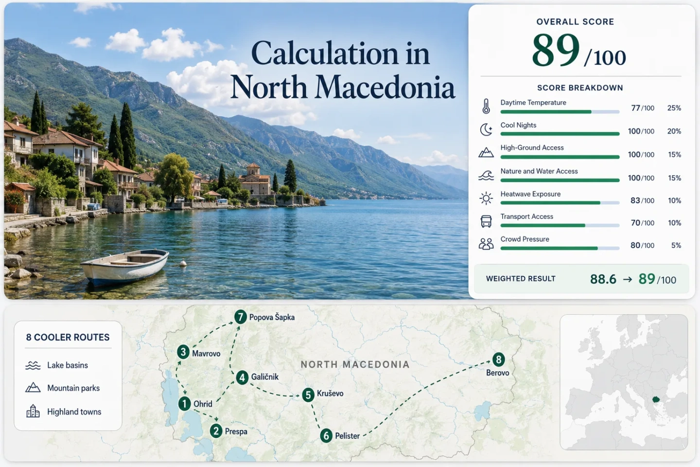
North Macedonia Summer Cooldowns: Lake Towns, Mountain Parks and Highland Air
North Macedonia’s strongest July–August relief comes from a compact west-to-east chain of lake basins, national parks and settlements above 800 metres. Ohrid and Prespa add open-water breezes and swimming access, while Mavrovo, Galičnik, Kruševo, Pelister and Popova Šapka shift the overnight pattern toward cooler highland air. The trade-off is clear: the coolest bases are usually the most road-dependent.
Two lake bases, four mountain-park gateways and two eastern or northern highland options form the scoring set.
A lodging zone around 1,780 metres gives the clearest daytime and overnight altitude advantage.
Ohrid offers stronger services; Prespa offers a quieter basin and easier access to rural shore villages.
High villages and park-edge bases regularly separate from the warmer lowland valleys after sunset.
Intercity buses reach the main towns, but trailheads, lake coves and high villages often require a car or arranged transfer.
Lakes, National Parks and Highland Bases Across North Macedonia
The eight markers follow the same route set used in the score and comparison matrix, from Lake Ohrid and Prespa to Mavrovo, Baba Mountain, Šar Mountain and the Maleševo highlands.
Markers show selected cooler-route regions and approximate planning centres, not guaranteed legal parking, trailheads or exact viewpoints. Use each route card for Google Maps links and confirm park access before travelling.
North Macedonia Lake and Highland Suitability Score
A transparent editorial suitability index based on disclosed climate, landscape, access and pressure factors. It is not an official climate classification or a weather forecast.
Method: Route-centre maximum-temperature proxy. Published July–August station means were paired with high/low climatology and elevation bands; the median was normalized on the fixed daytime scale.
Raw: Median July–August daily maximum proxy: 24.8°C.
Route values: Ohrid and Galičica 28.0°C; Prespa and Resen 27.0°C; Mavrovo National Park 24.0°C; Galičnik and Lazaropole 23.0°C; Kruševo 25.0°C; Pelister and Nižepole 24.5°C; Popova Šapka and Šar Mountain 21.5°C; Berovo and Maleševo Mountains 26.0°C. Median: 24.8°C.
Source mapping: Ohrid, Resen, Kruševo, Berovo and Lazaropole use published station-area values; Mavrovo, Nižepole and Popova Šapka use nearby station evidence adjusted to the lodging-zone elevation. These are planning proxies, not direct normals for every marker.
Period: Published station table 2010–2020; 1991–2020 national climatology used as context.
Sources: University of Tetova station-temperature study; World Bank Climate Knowledge Portal; North Macedonia 1991–2020 climate assessment.
Method: Route-centre minimum-temperature proxy using the same station and elevation mapping as the daytime factor. The factor measures overnight relief rather than record cold.
Raw: Median July–August daily minimum proxy: 10.8°C.
Route values: Ohrid and Galičica 14.5°C; Prespa and Resen 13.0°C; Mavrovo National Park 10.5°C; Galičnik and Lazaropole 9.5°C; Kruševo 11.0°C; Pelister and Nižepole 10.0°C; Popova Šapka and Šar Mountain 7.5°C; Berovo and Maleševo Mountains 12.5°C. Median: 10.8°C.
Source mapping: Direct station-area evidence is strongest for Ohrid, Resen, Kruševo, Berovo and Lazaropole. Higher park bases use conservative elevation-adjusted proxies and therefore lower the comparability grade.
Period: Published station table 2010–2020; route-centre proxy review completed 15 July 2026.
Sources: University of Tetova station-temperature study; WMO Ohrid climate page; Open-Meteo historical data documentation.
Method: Fixed elevation-and-access rubric; each route is scored independently and the route median is used.
Raw: Route-score median: 100/100.
Route scores: Ohrid and Galičica 80; Prespa and Resen 80; Mavrovo National Park 100; Galičnik and Lazaropole 100; Kruševo 100; Pelister and Nižepole 100; Popova Šapka and Šar Mountain 100; Berovo and Maleševo Mountains 80. Median: 100/100.
Route rationale: Five bases sit near or above 900 metres; Ohrid, Resen and Berovo retain regular access to mountain ground above 1,000 metres within roughly an hour.
Period: Elevation and access reviewed 15 July 2026.
Sources: Public Institution Mavrovo National Park; Pelister National Park; UNEP Šar Mountain National Park profile; North Macedonia official tourism portal.
Method: Fixed rubric for physical access to broad forest, a large lake or river system within 30 minutes; route median.
Raw: Route-score median: 100/100.
Route scores: Ohrid and Galičica 100; Prespa and Resen 100; Mavrovo National Park 100; Galičnik and Lazaropole 75; Kruševo 75; Pelister and Nižepole 100; Popova Šapka and Šar Mountain 75; Berovo and Maleševo Mountains 100. Median: 100/100.
Route rationale: Ohrid, Prespa, Mavrovo and Berovo combine water with forest access; Pelister adds extensive forest and glacial lakes. Galičnik, Kruševo and Popova Šapka score for one strong highland or forest element.
Period: Geographic access reviewed 15 July 2026.
Sources: Ministry of Foreign Affairs visitor information; Mavrovo National Park; Pelister National Park; UNESCO Ohrid Region.
Method: Disclosed proxy exposure calculation for the 30°C threshold. Published station extremes, regional tropical-day evidence and altitude-adjusted route climatology were converted to percentage equivalents; these are comparative exposure estimates, not exact station-day counts.
Raw: Median 30°C-or-higher exposure proxy: 3.5% of July–August days.
Route values: Ohrid and Galičica 11%; Prespa and Resen 8%; Mavrovo National Park 3%; Galičnik and Lazaropole 1%; Kruševo 4%; Pelister and Nižepole 2%; Popova Šapka and Šar Mountain 0.5%; Berovo and Maleševo Mountains 7%. Median: 3.5%.
Source mapping: Lower lake basins receive higher exposure bands; lodging zones above roughly 1,200 metres receive lower bands. The proxy treatment is the main reason for comparability quality C.
Period: Target comparison window 2016–2025; published station evidence includes 2010–2020 and longer-term climate context.
Sources: Published North Macedonia temperature and tropical-day evidence; National climate assessment; Historical reanalysis method documentation.
Method: Fixed public-transport and access-complexity rubric; route median.
Raw: Route-score median: 70/100.
Route scores: Ohrid and Galičica 100; Prespa and Resen 80; Mavrovo National Park 40; Galičnik and Lazaropole 40; Kruševo 80; Pelister and Nižepole 40; Popova Šapka and Šar Mountain 40; Berovo and Maleševo Mountains 60. Median: 70/100.
Route rationale: Ohrid, Resen, Kruševo and Berovo have usable intercity links. The national-park trailheads and high villages rely on road transfers, taxis or a private vehicle after the nearest bus or rail hub.
Period: Access pattern reviewed 15 July 2026; timetables should be rechecked for the travel date.
Sources: Galeb Ohrid operator; Ministry of Transport; Official tourism travel information; Mavrovo park access information.
Method: Fixed categorical pressure rubric using official tourism reporting, protected-area capacity signals and route-specific booking concentration; route median.
Raw: Route-score median: 80/100.
Route scores: Ohrid and Galičica 40; Prespa and Resen 80; Mavrovo National Park 60; Galičnik and Lazaropole 80; Kruševo 80; Pelister and Nižepole 80; Popova Šapka and Šar Mountain 80; Berovo and Maleševo Mountains 80. Median: 80/100.
Route rationale: Ohrid carries the clearest July–August accommodation and shore pressure. Mavrovo has weekend and event peaks, while the remaining highland bases usually have lower total demand but smaller lodging inventories.
Period: Latest complete national tourism reporting through 2025; route capacity reviewed 15 July 2026.
Sources: North Macedonia State Statistical Office tourism data; UNESCO Ohrid Region; Mavrovo National Park notices.
77×0.25 + 100×0.20 + 100×0.15 + 100×0.15 + 83×0.10 + 70×0.10 + 80×0.05
88.6 → 89/100
Lake Shores, Park Villages and High-Altitude Bases
The route set separates swimming-oriented lake stays from road-based highland bases. Temperatures are disclosed planning proxies from the score evidence rather than forecasts for a particular trip.
Ohrid and Galičica
Ohrid sits at roughly 695 metres beside Lake Ohrid, with a July–August daytime proxy near 28°C and a night proxy near 14.5°C. The lake moderates evenings and supports swimming, while the Galičica road creates a fast transition from the urban shore to viewpoints and trail access above 1,500 metres.
Prespa and Resen
Resen stands near 880 metres, while the Great Prespa shore spreads through a broad mountain basin. The route’s planning proxy is about 27°C by day and 13°C at night. Resen has the practical services; Stenje, Pretor and Brajčino provide quieter access to water, wetlands and mountain paths.
Mavrovo National Park
Mavrovo’s lodging zone is around 1,230 metres, producing a daytime proxy near 24°C and a night proxy near 10.5°C. Lake access, broad forest and the Bistra–Korab mountain system make it one of the clearest all-round cooldowns, but the park’s useful points are spread along winding roads.
Galičnik and Lazaropole
Galičnik and Lazaropole occupy the 1,250–1,350-metre band. Their route proxy is about 23°C by day and 9.5°C at night, placing them among the strongest sleep-comfort options. The villages have small accommodation inventories, limited public transport and a much slower rhythm than nearby lake towns.
Kruševo
Kruševo is built around 1,350 metres, giving a July–August proxy near 25°C by day and 11°C at night. Unlike a park-only base, it combines restaurants, museums and town services with immediate forest roads, paragliding terrain and short ridge access.
Pelister and Nižepole
Nižepole and the park-edge lodging zone sit around 1,050–1,150 metres below Baba Mountain, whose highest summit reaches 2,601 metres. The route proxy is about 24.5°C by day and 10°C at night. Molika pine forest and high glacial lakes make the cooling mechanism more altitude-and-shade driven than lake-breeze driven.
Popova Šapka and Šar Mountain
Popova Šapka’s resort zone is close to 1,780 metres, the highest sleeping base in the portfolio. Its daytime proxy is about 21.5°C and its night proxy about 7.5°C. Tetovo lies only around 20 kilometres away, but the final ascent and movement between trail areas remain road-dependent.
Berovo and Maleševo Mountains
Berovo sits near 850 metres in the far east, with a planning proxy around 26°C by day and 12.5°C at night. Berovo Lake, forest roads and nearby elevations above 1,000 metres create a useful inland alternative when western lake accommodation is crowded.
Ohrid and Prespa: Two Lakes, Different Summer Rhythms
The two lake basins are close on a map but solve different planning problems. Galičica separates them physically, and the road network concentrates services very unevenly.
Ohrid for Services and Car-Light Stays
Ohrid combines an airport, regular intercity buses, a walkable centre and the largest accommodation stock in the route set. That convenience comes with warmer urban afternoons and concentrated waterfront demand. A practical heat-response pattern is to use the town early and late, then move uphill toward Galičica during the hottest hours.
Prespa for Space and Rural Shore Access
Prespa’s settlements are smaller and farther apart. Resen handles supplies and transport; Stenje, Pretor and Brajčino shift the stay toward water, wetlands or mountain paths. The basin is less suited to spontaneous car-free movement, but it is more forgiving for travelers who value quiet evenings over urban choice.
Galičica as the Altitude Switch
The mountain road between the basins climbs from roughly 700–900 metres to high viewpoints and trail access above 1,500 metres. That vertical change is more reliable for daytime relief than expecting a lakeside breeze at every hour. Road conditions, park rules and fire restrictions should be checked before committing to a cross-mountain day.
Mavrovo and Galičnik: The Road-Based Highland Gap
Short Map Distances, Slow Mountain Transfers
Mavrovo Lake, Galičnik, Lazaropole and the Radika valley sit within one western mountain system, yet ridge roads and valley geometry make short straight-line distances misleading. A 30-kilometre transfer can consume much more time than the map suggests, especially when the route leaves a main road for a village approach.
Planning decision: Keep one lodging base for two or three nights rather than moving every day between Mavrovo and the Bistra villages.
Cooler Nights Versus Smaller Service Networks
Galičnik and Lazaropole cool more strongly after sunset than the Mavrovo lakeside, but Mavrovo has the broader accommodation and restaurant network. The village pair is the stronger sleep-temperature choice; the lake is the stronger logistics choice.
Watch for: Fuel, cash access, food opening hours and return transport can become more consequential than distance in the high villages.
Pelister and Šar Mountain: When Elevation Matters More Than Lake Air
Pelister’s Forest-and-Trail Cooling
Pelister’s lower approach benefits from Molika pine shade before the route reaches open high ground and glacial lakes. Nižepole keeps the sleeping base above 1,000 metres, while Bitola remains close enough for rail and bus connections. This is the more balanced high-mountain option for travelers who still need a major city gateway.
Popova Šapka’s Colder Sleeping Base
Popova Šapka begins roughly 1,085 metres higher than Ohrid and about 430 metres higher than Kruševo. That elevation produces the strongest overnight relief in the portfolio, but it also increases wind exposure, weather volatility and dependence on the Tetovo access road.
A Heatwave Backup Hierarchy
When lower basins move above 30°C, the most defensible sequence is Popova Šapka first, Galičnik–Lazaropole second, then Mavrovo or Pelister. Ohrid and Prespa remain valuable for swimming, but water access does not guarantee a cool afternoon on the urban shore.
Eight Routes Compared by Elevation, Heat and Access
Every route used in the map and score appears here. Temperature figures are the disclosed July–August planning proxies; access ratings describe the practical car-light strength of the lodging base, not every trailhead.
| Route | Approximate Base Elevation | Day / Night Proxy | Primary Cooling Mechanism | Car-Light Strength | Most Useful Window |
|---|---|---|---|---|---|
| Ohrid and Galičica | 695 m | 28.0°C / 14.5°C | Lake air plus Galičica day climbs | High in town | Swimming and urban services; early June or September for lower pressure |
| Prespa and Resen | About 880 m | 27.0°C / 13.0°C | High lake basin and open rural shore | Moderate in Resen; low on remote shore | Lake villages, birding and quieter evenings |
| Mavrovo National Park | About 1,230 m | 24.0°C / 10.5°C | High lake, forest and mountain mass | Low to moderate | July–August multi-night park stays |
| Galičnik and Lazaropole | 1,250–1,350 m | 23.0°C / 9.5°C | Plateau elevation and night cooling | Low | Cool sleeping conditions outside event weekends |
| Kruševo | About 1,350 m | 25.0°C / 11.0°C | High-town elevation and forest edge | Moderate to high in town | Car-light highland town breaks |
| Pelister and Nižepole | 1,050–1,150 m | 24.5°C / 10.0°C | Pine forest and access to 2,000 m terrain | Low after Bitola | Hiking access from late June into September |
| Popova Šapka and Šar Mountain | About 1,780 m | 21.5°C / 7.5°C | Direct high-altitude exposure | Low | Lowest-heat lodging during July–August hot spells |
| Berovo and Maleševo Mountains | About 850 m | 26.0°C / 12.5°C | Forest lake and Maleševo uplands | Moderate in town | Eastern highland alternative with lower western-route demand |
July–August Timing by Travel Intent
Lowest-Heat Lodging
Late July through August: Popova Šapka, Galičnik, Lazaropole and Mavrovo retain the strongest altitude advantage. Nights can become cool enough for an extra layer even when Skopje and the low valleys remain hot.
Lake Swimming With Evening Relief
Mid-July through late August: Ohrid and Prespa offer the most dependable warm-water period. Ohrid has easier transport and more beaches; Prespa has more space but requires stronger road planning.
High-Trail Access
Late June through September: Pelister, Šar Mountain and Bistra routes generally provide the broadest snow-free hiking window, but storms, wind and temporary fire restrictions can alter access quickly.
Lower Booking Pressure
June and September: Ohrid and Mavrovo become easier to book, while Kruševo and Berovo keep useful town services. Lake water is cooler in June, and highland nights become noticeably colder in September.