Serbia for Cooler Summer Breaks: Mountain Resorts, River Valleys and Spa Towns
Serbia’s strongest summer-cooling pattern lies in the contrast between high mountain bases and lower spa or river-valley towns. Kopaonik, Zlatibor, Tara, Divčibare and Babin Zub provide elevation, forest cover and cooler nights, while Vrnjačka Banja, Sokobanja and Perućac combine water or spa access with warmer afternoons and nearby high-ground alternatives.
Five high-ground bases, two spa towns and one Drina lake-and-valley route share equal weight in the score.
The 1,710-metre RHMZ station records a July–August mean maximum of about 17.2°C for 1981–2010.
The disclosed station mapping places the median summer minimum inside the score’s strongest night-cooling band.
Their high lodging and trail bands provide the clearest separation from Serbia’s warmer basins during hot spells.
Regular intercity connections and concentrated visitor services make these easier without relying on a private vehicle every day.
Vrnjačka Banja, Sokobanja and Perućac retain river, lake or park advantages but do not remove 30°C risk at low elevation.
Serbia’s High Resorts, Spa Basins and Drina Corridor
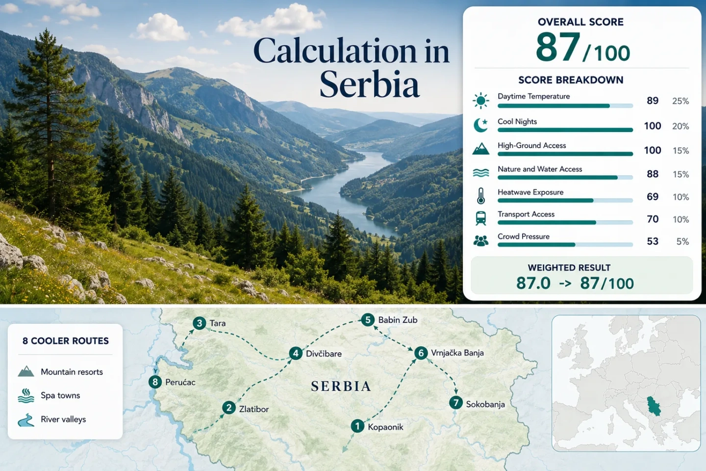
The markers connect Serbia’s western plateaus, central spa corridor, eastern highlands and the lower Drina valley. They represent planning centers rather than exact trailheads, viewpoints or legal parking areas.
Markers show selected cooler-route regions and approximate public location centers, not guaranteed legal parking, trailheads or exact viewpoints. Use the named Google Maps links and current local access information before traveling.
Serbia Mountain and Spa Cooler Escape Suitability Score
This transparent editorial suitability index uses disclosed climate, high-ground, water-and-forest access, transport and visitor-pressure factors. It is not an official climate classification or a weather forecast.
The score uses the median of eight equally weighted routes. Route quantity does not add points.
Method: Median of each route’s July–August mean daily maximum, followed by the fixed temperature normalization.
Raw: Route median 23.2°C.
Route values: Kopaonik 17.2°C; Zlatibor 23.2°C; Tara National Park 23.2°C; Divčibare 23.2°C; Stara Planina – Babin Zub 21.9°C; Vrnjačka Banja 28.5°C; Sokobanja 29.7°C; Perućac and Drina Valley 28.4°C.
Source mapping: Kopaonik uses direct station MOSS 13378 at 1,710 m. Zlatibor uses direct station MOSS 13367 at 1,028 m. Tara National Park and Divčibare use Zlatibor as an elevation-matched western-upland representative; Kaluđerske Bare is roughly 40–45 km away with a similar base band, while Divčibare is roughly 70 km away and about 50 m lower. Babin Zub uses Crni Vrh MOSS 13289 as an eastern high-ground representative, roughly 95 km away and about 540–720 m below the principal resort and summit band. Vrnjačka Banja uses Kraljevo MOSS 13376, roughly 20 km away at a similar valley elevation. Sokobanja uses Zaječar MOSS 13392, roughly 45 km away and about 250 m lower. Perućac uses Loznica MOSS 13262, roughly 60 km north along the Drina corridor and about 170 m lower.
Period: 1981–2010.
Sources: RHMZ Kopaonik station table; RHMZ Zlatibor station table; RHMZ Crni Vrh station table; RHMZ Kraljevo station table; RHMZ Zaječar station table; RHMZ Loznica station table.
Method: Median of mapped July–August mean daily minimum temperatures.
Raw: Route median 12.9°C, inside the 10–16°C full-score band.
Route values: Kopaonik 8.6°C; Zlatibor 12.8°C; Tara National Park 12.8°C; Divčibare 12.8°C; Stara Planina – Babin Zub 13.1°C; Vrnjačka Banja 15.1°C; Sokobanja 14.1°C; Perućac and Drina Valley 15.8°C.
Source mapping: The same direct and representative station assignments disclosed for daytime temperature are used. The values describe historical station minima rather than guaranteed overnight conditions at every hotel or lakeshore.
Period: 1981–2010.
Sources: RHMZ 30-year averages index and the six linked station tables disclosed in the daytime-temperature factor.
Method: Fixed categorical rubric based on lodging elevation or practical access to meaningful high ground within about 60 minutes.
Route scores: Kopaonik 100 — lodging and station band near 1,700 m; Zlatibor 100 — base near 1,000 m; Tara National Park 100 — Kaluđerske Bare and Mitrovac near 1,000–1,080 m; Divčibare 100 — resort base around 980 m; Stara Planina – Babin Zub 100 — principal access band above 1,100 m with Babin Zub at 1,758 m; Vrnjačka Banja 80 — low spa base with Goč above 1,100 m reachable by local road; Sokobanja 60 — base near 400 m with mountain trailheads nearby but less direct high-altitude access; Perućac and Drina Valley 80 — low lakeside base with the Tara plateau reached by a steep local road.
Raw: Median route score 100.
Period: Access and published destination conditions reviewed July 15, 2026.
Sources: Kopaonik National Park hiking information; Tara National Park visitor information; National Tourism Organisation Divčibare profile; Ski Resorts of Serbia Stara Planina profile; Vrnjačka Banja Tourist Organization; Sokobanja Tourism Organization.
Method: Fixed physical-access rubric. Serbia has no sea coast, so scoring depends on substantial forest, lake or river access.
Route scores: Kopaonik 75 — extensive mountain forest; Zlatibor 100 — forest plus reservoir and lake access; Tara National Park 100 — forest, Drina canyon and multiple reservoirs; Divčibare 75 — strong forest and stream access; Stara Planina – Babin Zub 75 — forest, streams and waterfall valleys but no large water body beside the resort; Vrnjačka Banja 75 — wooded spa park and mountain hinterland; Sokobanja 100 — Moravica River, Bovan Lake and surrounding forested mountains; Perućac and Drina Valley 100 — Drina River, Lake Perućac and Tara forest access.
Raw: Median 87.5, rounded to 88/100.
Period: Current public access reviewed July 15, 2026.
Sources: Tara National Park; Tara–Drina Tourist Organization Lake Perućac profile; National Tourism Organisation Stara Planina profile; Divčibare landscape profile; Sokobanja nature and water information.
Method: Official threshold-frequency fallback. RHMZ’s mean number of tropical days, defined in the station tables as days reaching at least 30°C, was summed for July and August and divided by 62 calendar days. This is not a claimed extraction of the latest ten summers.
Route values: Kopaonik 0 of 62 equivalent days, 0.0%; Zlatibor 4 of 62, 6.5%; Tara National Park 4 of 62, 6.5%; Divčibare 4 of 62, 6.5%; Stara Planina – Babin Zub 2 of 62, 3.2%; Vrnjačka Banja 24 of 62, 38.7%; Sokobanja 31 of 62, 50.0%; Perućac and Drina Valley 24 of 62, 38.7%.
Raw: Median 6.5% of July–August days. Linear interpolation between the fixed 5% and 10% thresholds gives 69/100.
Coverage: The values are published 30-year frequencies, so daily-series valid-day coverage is not applicable to this fallback method.
Period: 1981–2010.
Sources: RHMZ station tables for Kopaonik, Zlatibor, Crni Vrh, Kraljevo, Zaječar and Loznica.
Method: Fixed categorical rubric based on intercity arrival, transfer complexity and the need for a vehicle after reaching the destination.
Route scores: Kopaonik 60 — long road access with limited public-transport flexibility; Zlatibor 100 — frequent direct coaches and concentrated local services; Tara National Park 40 — intercity access to Bajina Bašta followed by restricted local mobility; Divčibare 80 — regular road-coach access, with trails near the resort core; Stara Planina – Babin Zub 40 — remote final approach and strong car dependence; Vrnjačka Banja 100 — regular road and rail corridor access; Sokobanja 80 — direct regional coach access but limited onward mountain transport; Perućac and Drina Valley 40 — Bajina Bašta connections followed by local road dependence.
Raw: Median route score 70.
Period: Published transport and access information reviewed July 15, 2026; schedules remain subject to operator changes.
Sources: Zlatibor Tourist Organization timetable; Vrnjačka Banja connectivity information; Belgrade Bus Station Vrnjačka Banja service; Tara National Park visitor access; Divčibare destination information; Stara Planina resort information.
Method: Categorical pressure proxy because route-level July–August occupancy percentages are not published consistently. Official 2024 overnight totals identify the highest-volume mountain and spa resorts; park scale, road capacity and major-event pressure separate the remaining routes.
Route scores: Kopaonik 40 — 636 thousand overnight stays in 2024; Zlatibor 20 — about 1.2 million overnight stays; Tara National Park 65 — dispersed lodging but concentrated viewpoint roads and summer weekends; Divčibare 65 — weekend pressure without Zlatibor-scale annual volume; Stara Planina – Babin Zub 85 — lower published demand and remote access; Vrnjačka Banja 40 — 626.2 thousand overnight stays; Sokobanja 40 — 493.1 thousand overnight stays; Perućac and Drina Valley 65 — generally dispersed except major summer event dates and swimming weekends.
Raw: Median categorical score 52.5, rounded to 53/100.
Period: Official tourism totals for January–December 2024; park and event access reviewed July 15, 2026.
Sources: Statistical Office of the Republic of Serbia, fourth-quarter and annual 2024 bulletin; Tara National Park visitor information; Tara–Drina Tourist Organization regatta information.
Weighted total: 89×0.25 + 100×0.20 + 100×0.15 + 88×0.15 + 69×0.10 + 70×0.10 + 53×0.05 = 87.0 → 87/100
Mountain Resorts, Spa Basins and the Drina Valley
The eight routes do not provide the same kind of relief. High resorts reduce daytime temperature directly, while the spa and river bases work through shaded parks, water access, cooler nights and short transfers toward surrounding mountains.
Kopaonik
The highest and coolest lodging base in the route set is supported by a direct RHMZ station at 1,710 metres. Its 1981–2010 July–August means are about 17.2°C by day and 8.6°C at night, with no average tropical days in either target month.
Summer hiking programs operate inside the national park, but the long road approach and limited local public transport make a central resort stay more practical than moving between distant trailheads.
Zlatibor
The 1,028-metre official station gives Zlatibor a July–August mean maximum of 23.2°C and mean minimum of 12.8°C. Four average tropical days across the two months show that hot afternoons remain possible, but the plateau still keeps a large advantage over Serbia’s lowland cities.
Transport is the main practical strength: regular long-distance coaches serve the resort, and restaurants, shops and accommodation are concentrated around the town center.
Forest roads, Ribničko Lake and the Tornik area make it possible to change elevation or move toward water without relocating to another region.
Tara National Park
Kaluđerske Bare sits just above 1,000 metres, Mitrovac is around 1,080 metres, and the park’s central plateau is cut by forest, gorges and reservoir lakes. The nearest elevation-matched official climate proxy, Zlatibor, gives a July–August 23.2°C daytime and 12.8°C night normal.
Banjska Stena is about 6 km from Mitrovac, while the road between Mitrovac and Perućac compresses a major elevation change into a short geographic distance. A vehicle is useful for viewpoints, visitor centers and lake transfers.
Divčibare
Divčibare occupies the central Maljen plateau at roughly 980 metres, close to Zlatibor’s station elevation even though the two resorts are separated geographically. The elevation-matched proxy contributes a 23.2°C July–August mean maximum, a 12.8°C minimum and four average 30°C days.
Successive belts of coniferous and deciduous forest, local streams and nearby walking routes allow shorter shaded outings without committing to high alpine terrain.
Stara Planina – Babin Zub
Babin Zub rises to 1,758 metres and sits within a resort system extending from roughly 1,100 to 1,900 metres. Crni Vrh is used as a regional high-ground climate representative and records a July–August mean maximum of 21.9°C, minimum of 13.1°C and two average tropical days.
Altitude is stronger than transport convenience. The eastern location and final mountain road make a private vehicle valuable, while exposed hikes require current thunderstorm, wind and cloud checks.
Vrnjačka Banja
Vrnjačka Banja is a low spa base rather than a consistently cool mountain resort. The representative Kraljevo station gives a July–August mean maximum of 28.5°C, minimum of 15.1°C and about 24 average tropical days across the two months.
Road and railway links through the West Morava corridor support car-light arrival. Goč reaches 1,127 metres and adds a meaningful high-ground option without changing accommodation every night.
Sokobanja
Sokobanja stands near 400 metres between Ozren and Rtanj, with the Moravica River crossing the basin. The Zaječar representative station is warmer than the town’s higher neighborhoods but signals the regional heat risk: a 29.7°C July–August mean maximum, 14.1°C minimum and 31 average tropical days.
River walks, spa facilities and nearby forested slopes diversify the day, but the basin should not be treated as a heat-proof destination. Early walking hours and higher Ozren or Rtanj approaches matter during strong hot spells.
Perućac and Drina Valley
Lake Perućac lies at about 290 metres and extends roughly 54 km through the Drina canyon, with water depths reaching about 60 metres. The Loznica station proxy gives a July–August mean maximum of 28.4°C, minimum of 15.8°C and 24 average tropical days.
The route works through water access plus vertical flexibility, not through consistently low valley temperatures. Mitrovac is about 13 km away by mountain road, creating a practical switch between lake time and a 1,000-metre plateau.
Eight Bases by Heat, Access and Water
The same eight routes used by the map and score are compared through elevation, mapped climate values, transport practicality and the main summer trade-off.
| Route | Base or Main Band | July–August Max / Min | 30°C+ Frequency Proxy | Car-Light Access | Main Summer Trade-Off |
|---|---|---|---|---|---|
| Kopaonik | About 1,700 m | 17.2°C / 8.6°C | 0 of 62 days | Limited | Lowest heat, longer road approach |
| Zlatibor | About 1,000 m | 23.2°C / 12.8°C | 4 of 62 days | Strong | Easy services, higher booking pressure |
| Tara National Park | 1,000–1,080 m plateau | 23.2°C / 12.8°C | 4 of 62 days | Limited | Forest depth, dispersed road access |
| Divčibare | About 980 m | 23.2°C / 12.8°C | 4 of 62 days | Moderate | Compact upland, smaller route network |
| Stara Planina – Babin Zub | 1,100–1,758 m | 21.9°C / 13.1°C | 2 of 62 days | Limited | Strong altitude, remote final access |
| Vrnjačka Banja | About 230 m | 28.5°C / 15.1°C | 24 of 62 days | Strong | Spa convenience, warm valley afternoons |
| Sokobanja | About 400 m | 29.7°C / 14.1°C | 31 of 62 days | Moderate | Mountain setting, persistent basin heat risk |
| Perućac and Drina Valley | About 290 m | 28.4°C / 15.8°C | 24 of 62 days | Limited | Swimming access, sharp heat difference from Tara |
Tara’s Plateau-to-Drina Drop Changes the Day
Tara and Perućac can appear to be one compact destination on a map, yet their elevation bands create two different summer environments.
Plateau Nights at Kaluđerske Bare and Mitrovac
Kaluđerske Bare and Mitrovac sit near the 1,000-metre band, with forest cover and cooler mapped night temperatures. Sleeping on the plateau reduces the need to climb back up after a hot lakeside afternoon.
Perućac’s Swimming Window
Perućac provides a designated swimming area and immediate Drina-canyon water access, but its 290-metre elevation places it much closer to western Serbia’s hot valley climate.
Regatta and Weekend Pressure
The Drina Regatta is traditionally associated with the third week of July and can bring very heavy local traffic. Current dates and road arrangements should be checked before combining Perućac with Tara during that period.
Kopaonik and Babin Zub as Heatwave Reserve Bases
Kopaonik Holds the Lowest Station Values
Kopaonik’s direct 1,710-metre station is the clearest measured departure from Serbia’s lowland heat. The main compromise is logistical: reaching the resort takes longer, and a poorly placed lodging choice can make trail transfers vehicle-dependent.
Babin Zub Trades Convenience for Elevation
Stara Planina’s high resort band is less urbanized and less connected than Zlatibor. That remoteness reduces some booking pressure while increasing dependence on the final mountain road, fuel planning and current access information.
Spa Towns Need a Two-Part Summer Day
Vrnjačka Banja and Sokobanja provide useful parks, spa services and mountain links, but their low or basin elevations do not justify treating them like Kopaonik or Tara.
Vrnjačka Banja Before the Afternoon Peak
Park walks and central spa facilities fit the morning and evening more reliably. Goč supplies the stronger high-ground option when the West Morava corridor enters a hot spell.
Sokobanja Between River and Mountain
The Moravica, Ozren and Rtanj widen the activity range, yet the official regional proxy shows frequent 30°C days. Shaded routes should not be confused with a low daytime temperature.
Transport Offsets Some Heat Risk
Both towns are easier to reach than remote mountain trailheads. They suit trips where medical, wellness, dining and family services matter alongside access to cooler morning or high-ground excursions.