Central Asia’s Cooler Mountain Routes
Central Asia’s most dependable summer temperature changes happen vertically. From the hot lowlands around Almaty and Tashkent, established roads and lifts reach 1,600–2,200-metre mountain bases; farther east, Kyrgyz and Pamir routes place overnight stops above 3,000 metres, where the planning problem shifts from finding relief to managing cold nights, rough roads, sparse services and high-altitude exposure. The routes here separate easy mountain access from true high-plateau travel rather than treating every mountain destination as equally cool.
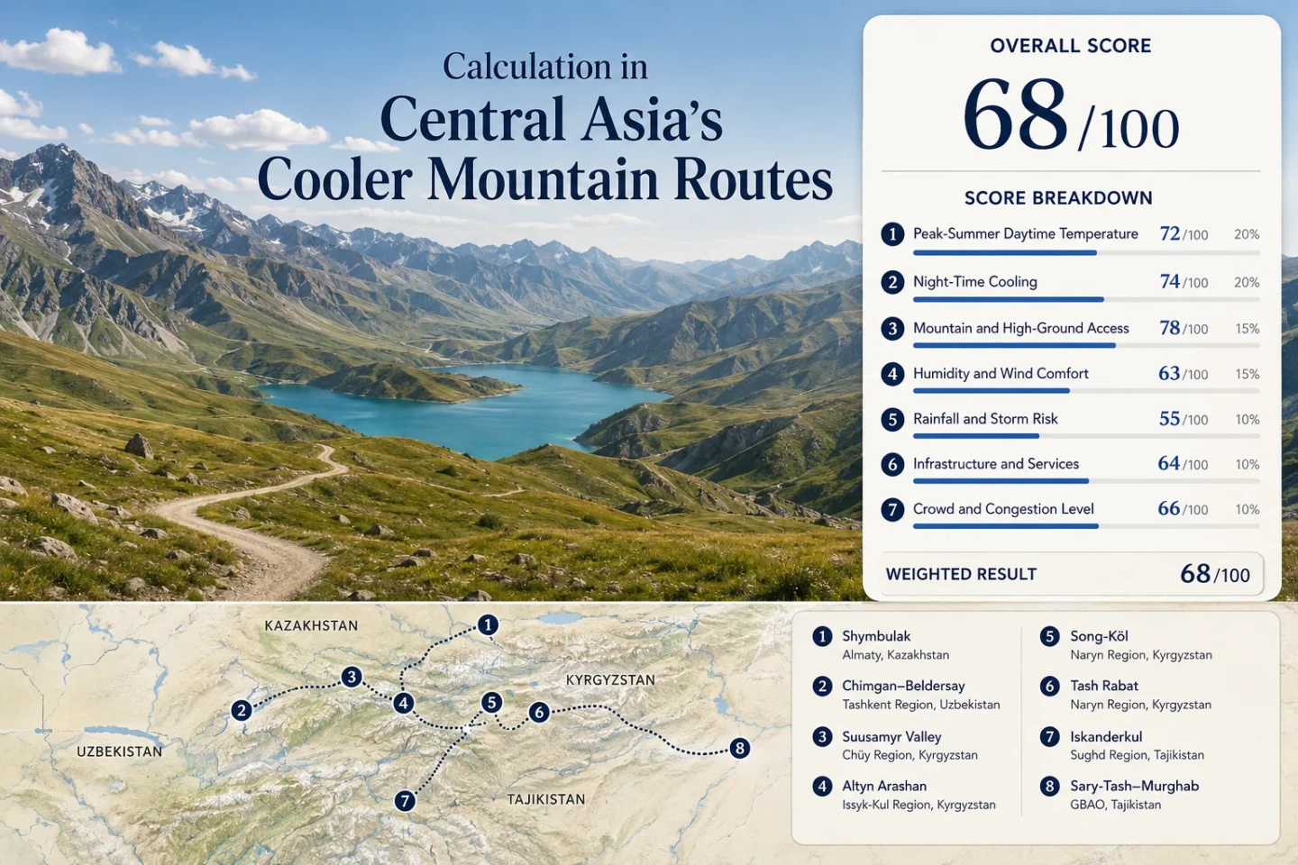
The shared set runs from the western Tien Shan near Tashkent to the eastern Pamir around Murghab.
Chimgan forms the lower mountain end; Murghab represents the high-plateau end, with Pamir passes rising well above 4,000 m.
A 2,200 m resort base above Almaty combines established lift infrastructure with hotels and restaurants in the same mountain corridor.
Song-Köl, Tash Rabat and the Murghab corridor move the overnight base into a much colder summer altitude band.
Shymbulak and Chimgan–Beldersay trade some high-plateau cold for simpler access from major cities.
Long overland stages, 4,000 m passes, sparse vehicle services and GBAO entry requirements make the Pamir route a different category of trip.
From the Western Tien Shan to the Eastern Pamir
The route set follows three distinct mountain systems: the Tien Shan corridors of Kazakhstan, Uzbekistan and Kyrgyzstan; the Fann Mountains of western Tajikistan; and the much higher Pamir plateau. The spread matters because a 1,600 m resort reached from a capital city and a 3,600 m plateau town reached across high passes solve the summer-heat problem in very different ways.
Markers show route planning centres rather than exact trailheads, legal parking points or border-control locations. High roads, seasonal tracks and permit zones require separate access checks before travel.
Eight Mountain Routes With Different Cooling Trade-Offs
The useful distinction is not simply “mountain versus lowland.” Base elevation, whether the cooler altitude is reached by lift or rough road, the availability of an overnight stay, and the speed of night-time cooling all change what the route can realistically do during a July or August heat spell.
Shymbulak: Almaty’s Lift-Supported Vertical Shift
Shymbulak sits within the Trans-Ili Alatau above Almaty, with the resort extending from about 2,200 m to 3,180 m. That elevation range is reached through an established resort corridor rather than a remote mountain road. Hotels, restaurants and seasonal lift operations make it possible to spend the hotter part of the day higher up without turning the move into a multi-day expedition.
The cooling advantage is strongest when the actual day is spent at resort or upper-lift elevation. Almaty remains the lowland gateway; returning to the city every evening gives up part of the night-cooling benefit.
Chimgan–Beldersay: Mountain Relief Without 3,000-Metre Sleeping Altitude
Chimgan’s resort area is around 1,600 m, while Beldersay is around 1,700 m. Greater Chimgan rises to 3,309 m, but the normal accommodation zone is much lower than Song-Köl, Tash Rabat or Murghab. That difference explains why the route works as a practical escape from Tashkent without delivering the same cold-night character as Kyrgyzstan’s highest overnight bases.
Chimgan lies roughly 80 km from Tashkent, while Beldersay is about 85 km from the capital. The route is therefore road-based but still within the range of a short mountain stay rather than a long overland crossing.
Suusamyr Valley: Crossing Too-Ashuu Into a 2,000-Metre Pasture Basin
The Suusamyr Valley lies mostly around 2,000–2,200 m. The approach from Bishkek crosses the Too-Ashuu high-road corridor, with the tunnel area around 3,400 m, before dropping into the broad pasture basin. A commonly quoted road distance from Bishkek is about 170 km, with private-road travel around three hours when conditions cooperate.
Suusamyr is useful for travelers who want stronger night release than the Tashkent-area resorts without committing to Song-Köl’s rougher seasonal access or Pamir-scale distances.
Altyn Arashan: Where the Cooler Route Leaves the Normal Road
Altyn Arashan’s high valley sits around 2,600 m above the Karakol area. The final approach changes the category of the trip: the established option is a two- to three-hour walk from the trailhead, while rugged 4WD transfers can shorten the climb when the track is usable.
The valley combines altitude, forest, a fast mountain river and basic guesthouse accommodation. That produces a different cooling pattern from Song-Köl’s open plateau: Altyn Arashan is more sheltered, more topographically enclosed and lower, while still high enough for pronounced evening cooling.
Song-Köl: A 3,016-Metre Lake Where the Night Becomes the Main Cooling Event
Song-Köl sits at 3,016 m on an open high plateau. Tourist access is concentrated in the snow-free season, broadly June to September, and the common road approach from Kochkor takes several hours on rough mountain tracks. Regular public marshrutka service does not run to the lake; 4WD transfer or an organized horse route is the practical pattern.
Song-Köl therefore works differently from a mountain day trip. The main value is not just spending an afternoon above 3,000 m; it is remaining on the plateau through the night. That is also why warm sleeping layers belong in a trip chosen specifically to escape summer heat.
Tash Rabat: Sleeping at 3,200 Metres Instead of Merely Crossing a High Pass
Tash Rabat is set in a Naryn high valley at about 3,200 m. Naryn itself is around 2,040 m, so the road creates a real overnight elevation step rather than a short summit visit. The usual approach from Naryn runs via At-Bashy and takes roughly two to three hours by 4WD.
The final road is unpaved and summer-oriented. Local destination information advises against treating the approach as an ordinary sedan road, while snow can make the route impractical outside the main warm-season window.
Iskanderkul: Fann Mountain Cooling Without Pamir-Scale Altitude
Iskanderkul lies at about 2,195 m in the Fann Mountains. The lake gives the route a high-water setting as well as mountain elevation, but access remains road-dependent: there is no regular public transport to the lake, and the steep, rough final section is commonly treated as a 4WD route.
Compared with Murghab, the altitude burden is lower and the landscape is wetter and more enclosed. Compared with Shymbulak or Chimgan, the transport burden is higher. Iskanderkul occupies the middle of the spectrum: a genuine high-mountain overnight area without the 3,600–4,600 m exposure of the Pamir Highway.
Sary-Tash–Murghab: The High-Altitude End of the Cooling Spectrum
The Alay approach runs through terrain broadly in the 2,500–3,600 m band before the cross-border Pamir route climbs toward the 4,280 m Kyzyl-Art area. Murghab itself is around 3,600 m, while the Pamir Highway farther east reaches the Ak-Baital Pass at about 4,655 m.
This is not a city heat-escape day trip. Vehicle services are sparse, overland stages are long, road and border conditions matter, and the Tajik section enters Gorno-Badakhshan Autonomous Region, where foreign visitors require the applicable GBAO permission.
Cooling Strength Versus Access Effort
The most useful comparison is the amount of cooling gained for the transport and overnight burden required. “Night cooling” here is a route-character assessment based on elevation and exposure, not a live forecast or a substitute for a location-specific climate normal.
| Route | Practical Base Altitude | Primary Cooling Mechanism | Access Effort | Night-Cooling Character | Most Useful Role |
|---|---|---|---|---|---|
| Shymbulak | ~2,200 m resort base | Fast vertical rise above Almaty; upper lift terrain | Low | Strong | Short city-to-mountain heat escape |
| Chimgan–Beldersay | ~1,600–1,700 m | Western Tien Shan elevation near Tashkent | Low–moderate | Moderate | One- or two-night relief with limited route friction |
| Suusamyr Valley | ~2,000–2,200 m | High pasture basin reached across Too-Ashuu | Moderate | Strong | Road-trip cooling with a real overnight altitude gain |
| Altyn Arashan | ~2,600 m | High river valley, forest and enclosed mountain terrain | High | Strong–very strong | Active stay where the final approach is part of the trip |
| Song-Köl | 3,016 m | Open high plateau, dry air and strong night release | High | Very strong | Cold-night yurt stay during the seasonal road window |
| Tash Rabat | ~3,200 m | High valley sleeping altitude and exposed terrain | High | Very strong | Remote overnight base above 3,000 m |
| Iskanderkul | 2,195 m | Fann Mountain elevation plus high lake setting | High | Strong | Tajik mountain-lake stay without Pamir-scale altitude |
| Sary-Tash–Murghab | ~3,600 m at Murghab | High Pamir plateau and repeated 4,000 m passes | Very high | Very strong to cold | Multi-day overland route where altitude is central to the trip |
City-Linked Daytime Relief
Shymbulak and Chimgan–Beldersay keep the access burden lowest when the main aim is to leave a hot city and spend the day at higher elevation.
Mid-Altitude Overnight Cooling
Suusamyr Valley, Altyn Arashan and Iskanderkul move the sleeping base high enough for stronger evening cooling without making every night a 3,000 m-plus stay.
The 3,000 m-Plus Overnight Band
Song-Köl, Tash Rabat and Sary-Tash–Murghab shift the main cooling advantage toward the night, while clothing, access and altitude demands rise at the same time.
The Altitude Bands That Change the Trip
A single lapse-rate calculator would be misleading here. Sun exposure, valley inversions, wind, cloud, slope direction and overnight radiative cooling can move actual temperatures away from a simple metres-to-degrees formula. The altitude bands are still useful because they show when the travel logistics begin to change as much as the temperature.
1,600–1,700 m: Chimgan and Beldersay
This band is high enough to create clear relief from Tashkent’s lowland summer heat while retaining resort roads, hotels and a short transfer pattern. It is the easiest altitude tier in the route set.
2,000–2,200 m: Shymbulak, Suusamyr and Iskanderkul
Night cooling becomes more dependable, but access diverges sharply: Shymbulak has resort infrastructure, Suusamyr depends on the Too-Ashuu road, and Iskanderkul has no regular public transport to the lake.
Around 2,600 m: Altyn Arashan
The overnight base is high enough to feel markedly different from Karakol, yet the final walking or 4WD approach makes this altitude less convenient than a lift-served resort.
3,000–3,200 m: Song-Köl and Tash Rabat
Cold nights become a core planning issue. Seasonal roads, basic yurt or guesthouse accommodation and rapid weather changes matter as much as the daytime temperature advantage.
3,600 m and Higher: Murghab and the Pamir Passes
The route stops behaving like a normal summer resort trip. Acclimatization, long road stages, scarce vehicle support and permit or border checks become inseparable from the cooling benefit.
Shymbulak and Chimgan: High Ground Without an Expedition
Almaty to Shymbulak
The main advantage is vertical efficiency. The resort base begins around 2,200 m and continues to an upper lift zone above 3,000 m, yet the corridor remains tied directly to Almaty. This makes Shymbulak the cleanest example in the set of a hot-city base reaching high mountain terrain without a long intercity transfer.
Tashkent to Chimgan–Beldersay
The road distance is longer than Almaty’s lift-oriented shift, and the sleeping elevation is lower. The benefit is a simpler mountain-resort pattern than the rough-road Kyrgyz routes. The trade-off is that 1,600–1,700 m does not produce the same night-time cold as a 3,000 m plateau.
Song-Köl and Tash Rabat: The 3,000-Metre Overnight Difference
Both routes place the sleeping base above 3,000 m. That matters more than briefly touching the same elevation on a pass. Song-Köl’s 3,016 m plateau exposes yurts to open wind and rapid night-time heat loss, while Tash Rabat’s roughly 3,200 m valley makes the cold part of the overnight stay rather than a short daytime excursion.
Song-Köl Is a Seasonal Sleeping Landscape
The tourism pattern is tied to summer roads and temporary yurt camps. July and August bring the most reliable operating window but also stronger booking pressure; the route can still deliver near-freezing nights even when lower Central Asian cities are experiencing summer heat.
Tash Rabat Adds a Second Altitude Step After Naryn
Naryn already sits around 2,040 m. Continuing to Tash Rabat adds roughly another kilometre of sleeping elevation and replaces a regional town’s services with a remote high-valley road and simpler accommodation.
Iskanderkul or Murghab: Two Tajik Mountain Strategies
The Fann Mountains and the eastern Pamir should not be grouped as one Tajik “mountain climate.” They occupy different altitude, water and access systems.
Iskanderkul: Lake, 2,195 m and a Rough Final Road
Iskanderkul combines a high lake with Fann Mountain relief at an altitude that remains below the most demanding Pamir bases. There is no regular public transport to the lake, and the final road favors a capable vehicle, but the trip does not require repeated 4,000 m pass crossings.
Murghab: 3,600 m, Sparse Services and GBAO Rules
Murghab sits around 3,600 m in a dry high plateau environment. The route reaches far higher passes, vehicle support is thin, and foreign visitors entering Gorno-Badakhshan need the relevant special permission. Border status and GBAO entry requirements should be verified before committing to an Osh–Murghab crossing.
Elsewhere in the route set, lift and road status remain equally practical: Shymbulak depends on summer lift hours; Suusamyr on the Too-Ashuu corridor; Song-Köl and Tash Rabat on snow-free rough roads; and Altyn Arashan on the condition of its final mountain track. Monthly climate averages do not establish whether any of those access systems are usable on a specific day.