Kyrgyzstan for Mountain Summers: Alpine Lakes, High Pastures and Nomad Routes
Kyrgyzstan’s most convincing summer-cooling pattern begins above 1,600 metres and becomes pronounced on the jailoo pastures of the central Tian Shan. Alpine lakes, cold nights and open highland air can replace lowland heat, but the trade-off is logistical: the coolest routes often depend on seasonal passes, yurt camps, border permits or four-wheel-drive transfers.
Altitude, Access and the July–August Window
The route set spans Issyk-Kul, Naryn, the Chinese-border highlands, the Alay Valley and the walnut forests of Jalal-Abad.
Town, village and yurt-camp bases sit high enough for meaningful night cooling, although Arslanbob remains warmer than the central plateau routes.
These high bases carry the clearest daytime temperature advantage and the coldest nights in the assessed set.
Scheduled intercity transport reaches the town; local valleys still require a minibus, taxi or arranged trail transfer.
Yurt camps and high-road itineraries concentrate in the snow-free season, with July and August offering the broadest access.
Kel-Suu requires border-zone planning, while Song-Köl, Tash Rabat and the Alay high lakes depend on road and pass conditions.
Tian Shan Lakes, Pastures and Highland Bases
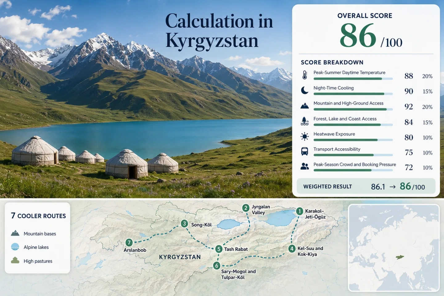
The seven markers connect relatively accessible mountain towns with remote yurt-camp landscapes. The map is intended for route orientation rather than navigation.
Markers show selected cooler-route regions and approximate planning centres, not guaranteed legal parking, trailheads or exact viewpoints. Use the place-specific Google Maps links and current local access information before travelling.
Kyrgyzstan Mountain-Summer Suitability Score
This transparent editorial suitability index uses disclosed climate, landscape, access and pressure factors for the seven mapped routes. It is not an official climate classification or a weather forecast.
Weighted total: 100×0.25 + 85×0.20 + 100×0.15 + 75×0.15 + 100×0.10 + 40×0.10 + 80×0.05 = 86.3 → 86/100
Method: Route count does not add bonus points. Route-level values are combined using the median before the fixed factor weights are applied. Comparability is rated C because coarse-grid climate proxies cannot fully resolve steep elevation changes between villages, passes and camps.
Alpine Lakes, Jailoo Pastures and Nomad-Road Bases
The route portfolio separates town-based access from high-camp travel. Temperature values are the same July–August proxy inputs used in the score, while access notes describe the practical difference between a road-served base and a remote lake objective.
Karakol–Jeti-Ögüz
Karakol sits around 1,770 metres and works as the most service-rich base in the set. The July–August proxy is 22.4°C by day and 10.6°C at night; Jeti-Ögüz adds a forested gorge and faster access to higher Terskey Ala-Too terrain.
Scheduled road transport reaches Karakol, while the gorge and trailheads require a minibus, taxi or arranged vehicle. The route is less remote than the central high lakes but also more exposed to peak-summer demand.
Jyrgalan Valley
Approximate base elevation: 2,300 metres. The proxy climate drops to 19.2°C by day and 8.1°C at night, creating a cooler starting point than Karakol before any ascent into the surrounding valleys.
Jyrgalan suits walkers and riders who want guesthouse accommodation close to high pasture. Local transport from Karakol is limited, and trail transfers should be confirmed rather than assumed.
Song-Köl
The lake lies near 3,016 metres, with a July–August proxy of 17.0°C by day and 5.8°C at night. Those numbers explain both its strong heat buffer and the need for insulated layers inside a yurt after sunset.
Approaches commonly use Kalmak-Ashuu or Moldo-Ashuu, and the practical season is tied to snow clearance and camp operation. July and August offer the broadest access but also the greatest booking pressure.
Kel-Suu and Kok-Kiya
Around the Kok-Kiya camp zone, nights are the defining feature: the proxy is 18.0°C by day and 5.0°C at night near 3,000 metres. The lake itself is reached after a remote border-zone drive and a final walk or horse approach.
Four-wheel-drive access, long transfer times and limited electricity make Kel-Suu a high-comfort-temperature choice but a low-convenience choice.
Tash Rabat
Tash Rabat combines a high valley, yurt accommodation and Silk Road history at roughly 3,200 metres. Its July–August proxy of 17.5°C by day and 4.2°C at night is the coldest overnight pattern in the assessed portfolio.
The road approach is simpler than Kel-Suu’s permit-controlled border route, but it remains a long transfer from major transport hubs. Chatyr-Köl and higher passes require separate planning rather than a casual side trip.
Sary-Mogol and Tulpar-Köl
Sary-Mogol provides a village base around 2,200 metres; Tulpar-Köl and the Achik-Tash side rise much higher beneath the Trans-Alay Range. The route proxy is 21.2°C by day and 8.0°C at night.
This is the clearest south-facing option for combining village services, yurt camps and views toward Lenin Peak. Shared-road access reaches the Alay Valley, but the final lake and camp transfer remains locally arranged.
Arslanbob
Arslanbob is the warm outlier: about 1,600 metres, with a July–August proxy of 27.0°C by day and 15.0°C at night. Its cooling value comes from forest shade, mountain access and evening relief rather than consistently low daytime temperature.
The village is more reachable than the remote Naryn lakes and supports a slower stay without yurt-camp logistics. During a regional heat event, however, Arslanbob is not equivalent to Song-Köl or Tash Rabat.
Kalmak-Ashuu, Moldo-Ashuu and the High-Road Calendar
Kyrgyzstan’s coolest road-served landscapes are not governed by temperature alone. Snow, washouts and the operating season of roadside camps determine whether a nominal summer route is practical.
Song-Köl Approaches
Kalmak-Ashuu is the commonly used eastern approach, while Moldo-Ashuu links the lake toward Naryn. Both climb above the pasture basin, so opening dates vary with winter snow and spring road damage. Mid-June should be treated as conditional, not as an automatic road-open date.
Tosor Pass Is an Expedition Link
The high connection between the Naryn interior and southern Issyk-Kul reaches roughly 3,893 metres and is used in organised off-road itineraries. It should not be treated as the ordinary transfer between Naryn and Karakol; vehicle condition, weather and local confirmation are central.
Alay Village and Lake Access Are Separate
Reaching Sary-Mogol does not complete the Tulpar-Köl journey. The village works as a service and permit-arrangement base, while the higher camp zone needs another local transfer. That split matters for arrival-day timing and for travellers using shared taxis.
Kel-Suu’s Border-Zone Sequence
Kel-Suu is not a spontaneous detour from Naryn. Passport information is normally submitted in advance, the road enters a controlled border area, and the final approach may involve horse travel or hiking from Kok-Kiya. The route’s low heat exposure therefore comes with the portfolio’s highest administrative and vehicle burden.
Planning order: Permit confirmation, vehicle arrangement, camp confirmation, then weather and road checks. Reversing that order can leave accommodation booked without legal access.
Cold Yurt Nights Versus Town-Based Flexibility
Song-Köl, Kel-Suu and Tash Rabat deliver the strongest overnight cooling, but 4–6°C proxy minima mean heavier sleep layers and limited indoor recovery. Karakol and Arslanbob provide shops, guesthouses and easier schedule changes, while Jyrgalan and Sary-Mogol sit between those two operating styles.
The lowest daytime temperature is not always the easiest trip. Travellers who need predictable transfers or private facilities may gain more from a slightly warmer town base with day trips into higher terrain.
Which Highland Route Matches the Travel Constraint?
All seven mapped routes appear in the same decision matrix. Temperature cells use the score inputs; access and pressure fields describe the main planning constraint rather than ranking scenery.
| Route | Base pattern | July–August day / night | Access mode | Lowest-heat window | Main trade-off |
|---|---|---|---|---|---|
| Karakol–Jeti-Ögüz | 1,770 m town and gorge | 22.4°C / 10.6°C | Regular road transport plus local transfer | July–August, with flexible town services | More visitors and warmer afternoons than the high camps |
| Jyrgalan Valley | Approx. 2,300 m village | 19.2°C / 8.1°C | Limited local transport from Karakol | July to early September for hiking access | Rain and transfer coordination |
| Song-Köl | 3,016 m lake and yurt camps | 17.0°C / 5.8°C | Seasonal pass road and arranged vehicle | July–August for broad camp and road access | Cold nights and peak yurt demand |
| Kel-Suu and Kok-Kiya | Approx. 3,000 m camp zone | 18.0°C / 5.0°C | Permit, four-wheel drive, then foot or horse | July–August after road and permit confirmation | Border administration and long transfers |
| Tash Rabat | Approx. 3,200 m valley camp | 17.5°C / 4.2°C | Long private-road transfer | July–August for the least cold nights | Very cold evenings and limited onward transport |
| Sary-Mogol and Tulpar-Köl | 2,200 m village plus higher camp | 21.2°C / 8.0°C | Long shared-road journey plus local transfer | July–August for high-lake and trekking access | Distance from Bishkek and final-mile logistics |
| Arslanbob | Approx. 1,600 m forest village | 27.0°C / 15.0°C | Regional road and local connections | June or September for lower heat pressure | Forest shade cannot fully offset hot regional days |
Yurt Camps, Passes and the Shoulder-Season Divide
Mid-June to Early July
Pastures green quickly, but high-road certainty is lower. Song-Köl camp openings, wet tracks and residual snow should be checked individually. Karakol, Jyrgalan and Arslanbob provide safer fallback bases when a high pass is delayed.
July to Mid-August
This is the broadest operating window for Song-Köl, Kel-Suu, Tash Rabat and Tulpar-Köl. It also concentrates organised departures and yurt demand. Reservations matter most where the road approach ends at a small camp rather than a town.
Late August to September
Daytime heat eases in Arslanbob and Karakol, while high-camp nights become sharper. Some camps reduce capacity before roads close. September works well for lower villages but requires a colder-weather margin at Song-Köl, Tash Rabat and Kel-Suu.
Checks That Matter Before Leaving Naryn, Karakol or Osh
Confirm the road, permit and overnight arrangement on the same day. A clear forecast does not confirm that a pass is open, a border permit is valid or a yurt camp is operating. For remote Naryn routes, carry a cold-night layer, cash, drinking-water capacity and enough schedule margin to return by a lower road if a high crossing changes.