Kazakhstan Coolcation Routes: Mountain Cities, Alpine Lakes and Wide Summer Skies
Kazakhstan’s most convincing summer cooldowns are concentrated in the Tien Shan above Almaty, the lake-and-pine landscapes around Saty, the taiga-facing city of Ridder and the broad upland parks of the north and east. The strongest routes pair cool nights, immediate high-ground access and large freshwater landscapes, while the main trade-off is distance: several of the least-hot areas require long road transfers after the nearest rail or air gateway.
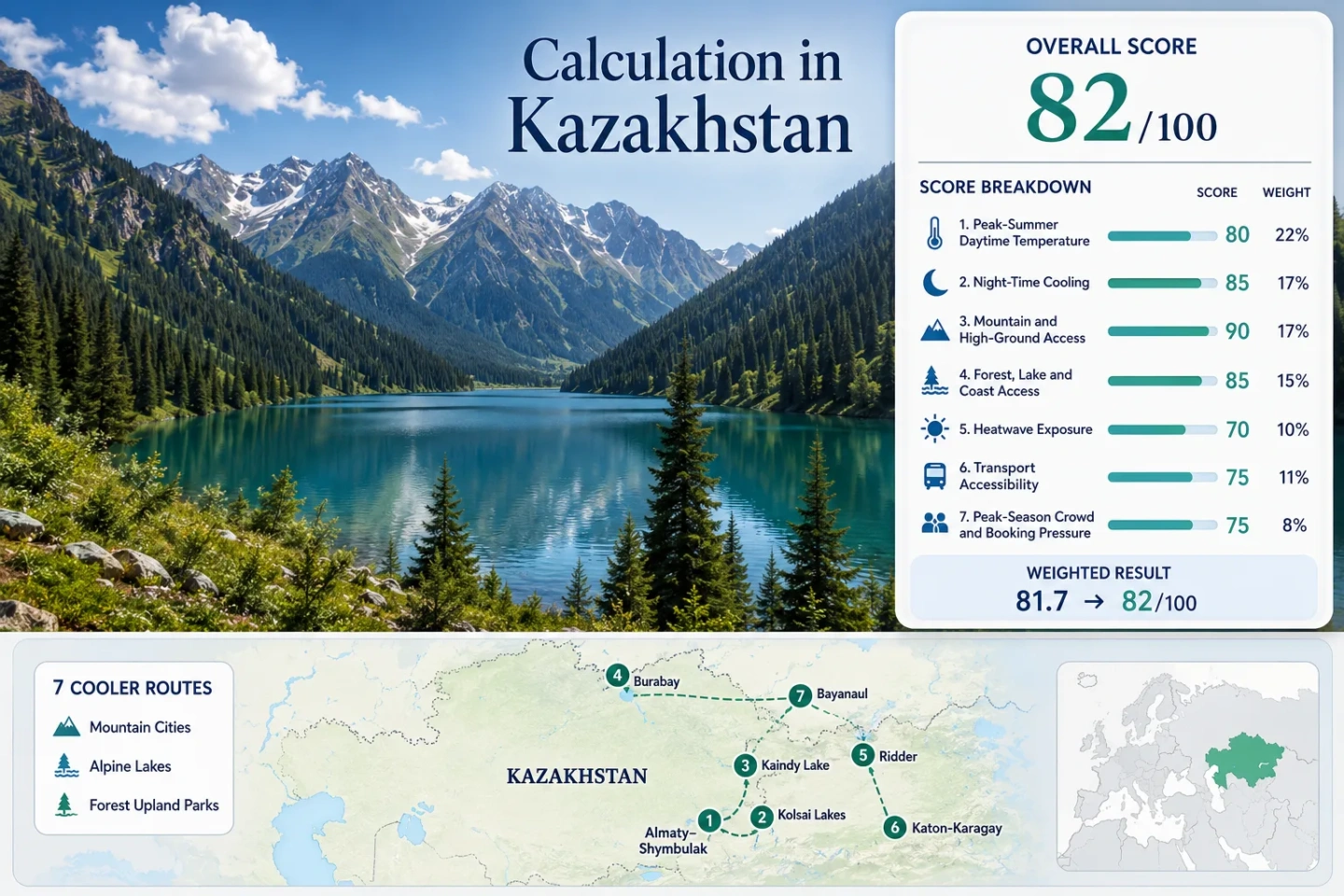
Two mountain-city corridors, two alpine-lake routes and three forested upland parks; route count does not add score points.
Both sit above the hot lowland belt, with cold water, spruce cover and night temperatures near the lower edge of the comfort band.
Urban bus access to Medeu and the gondola to the 2,260 m resort create the clearest no-car altitude gain.
A rail gateway, established accommodation and multiple lakes make it easier to assemble than the remote Altai routes.
The median route retains strong overnight cooling even where exposed steppe parks become warm in the afternoon.
Kaindy, Katon-Karagay and parts of Bayanaul need private transfers, infrequent local transport or rough-road planning.
Tien Shan Lakes, Northern Forests and Eastern Altai Bases
The route set stretches from Almaty’s immediate mountain wall to East Kazakhstan’s Altai valleys and the lake parks north of the central steppe.
Markers show selected cooler-route regions and planning centers, not guaranteed legal parking, trailheads or exact viewpoints. Use the route links and current local access information before traveling.
Kazakhstan Mountain and Lake Cooler Escape Suitability Score
This transparent editorial suitability index uses disclosed climate, landscape, access and pressure factors for the seven routes shown here. It is not an official climate classification or a weather forecast.
Each route carries equal weight. The route median is normalized for every factor, so a single cold alpine lake cannot lift the whole portfolio by itself.
Method: Proxy Dataset calculation using NASA POWER/MERRA-2 daily maximum temperature at each route-center coordinate; July and August days from 1991–2020 were averaged per route, then the seven route values were reduced to their median.
Raw: Median mean daily maximum 23.8°C, normalized by linear interpolation between 23°C = 90 and 25°C = 75.
Route values: Almaty–Medeu–Shymbulak 24.6°C; Kolsai Lakes 22.8°C; Kaindy Lake 21.6°C; Burabay–Shchuchye Lakes 26.2°C; Ridder–Ivanovsky Ridge 23.1°C; Katon-Karagay–Sarymsakty 23.8°C; Bayanaul–Zhasybai 27.7°C. Median: 23.8°C.
Source mapping: Route-center grid points: 43.1575, 77.0587; 42.9844, 78.3256; 42.9840, 78.4650; 53.0830, 70.3130; 50.3400, 83.5120; 49.1760, 85.6050; 50.7930, 75.7070. Variable: T2M_MAX in °C. These are gridded proxy values rather than direct high-elevation station normals.
Period: July–August 1991–2020.
Sources: NASA POWER Daily API documentation; NASA POWER parameter dictionary; Kazhydromet climate-zone context.
Method: Proxy Dataset calculation using NASA POWER/MERRA-2 daily minimum temperature at the same seven route-center grid points; route averages were reduced to the median.
Raw: Median mean daily minimum 11.2°C, inside the 10–16°C full-score comfort band.
Route values: Almaty–Medeu–Shymbulak 12.4°C; Kolsai Lakes 10.3°C; Kaindy Lake 9.1°C; Burabay–Shchuchye Lakes 14.8°C; Ridder–Ivanovsky Ridge 10.6°C; Katon-Karagay–Sarymsakty 11.2°C; Bayanaul–Zhasybai 15.6°C. Median: 11.2°C.
Source mapping: Same route-center coordinates as the daytime factor. Variable: T2M_MIN in °C. Gridded terrain smoothing may understate local cold-air pooling beside high lakes and overstate cooling in built-up bases.
Period: July–August 1991–2020.
Sources: NASA POWER Daily API documentation; NASA POWER temperature-variable definitions.
Method: Categorical Rubric based on accommodation-base elevation or regular access to higher ground within about 60 minutes.
Raw: Route-score median 80/100.
Route scores: Almaty–Medeu–Shymbulak 100 — regular access to Medeu and the 2,260 m resort base; Kolsai Lakes 100 — Lower Kolsai sits around 1,818 m; Kaindy Lake 100 — high-mountain lake approach near 2,000 m; Burabay–Shchuchye Lakes 30 — low rocky hills with limited altitude gain; Ridder–Ivanovsky Ridge 80 — city base around 800 m with nearby higher ridges; Katon-Karagay–Sarymsakty 80 — elevated village and valley bases with rapid access to higher ground; Bayanaul–Zhasybai 60 — low base but meaningful access toward 1,022 m Mount Akbet. Median: 80/100.
Route rationale: The portfolio contains three immediate high-altitude routes, two elevated eastern bases and two lower lake parks.
Period: Access conditions reviewed July 15, 2026.
Sources: Shymbulak official altitude information; UNESCO West Altai landscape profile; QazaqGeography Bayanaul elevations; Kazakh Tourism Katon-Karagay profile.
Method: Categorical Rubric measuring physical access to major forest, lake or river systems rather than scenery quality.
Raw: Route-score median 100/100.
Route scores: Almaty–Medeu–Shymbulak 75 — direct mountain-forest access; Kolsai Lakes 100 — large alpine lakes plus spruce forest; Kaindy Lake 100 — alpine lake plus spruce forest; Burabay–Shchuchye Lakes 100 — multiple major lakes plus pine forest; Ridder–Ivanovsky Ridge 100 — taiga forest plus Ulba river system; Katon-Karagay–Sarymsakty 100 — extensive forest, rivers and mountain lakes; Bayanaul–Zhasybai 100 — lakes, pine forest and granite uplands. Median: 100/100.
Route rationale: Six routes place at least two strong cooling landscapes within the immediate trip area; the Almaty corridor has one dominant forested mountain system.
Period: Landscape access reviewed July 15, 2026.
Sources: Kazakh Tourism Burabay profile; Kazakh Tourism Bayanaul profile; UNESCO West Altai Biosphere Reserve; Kazakh Tourism Katon-Karagay profile.
Method: Proxy Dataset calculation from NASA POWER/MERRA-2 T2M_MAX. For each route, July–August days reaching at least 30°C were counted across the ten completed summers from 2016 through 2025.
Raw: Median 30°C+ day share 6.8%, normalized by linear interpolation between 5% = 75 and 10% = 55.
Route values: Almaty–Medeu–Shymbulak 43/620 days, 6.9%; Kolsai Lakes 27/620, 4.4%; Kaindy Lake 13/620, 2.1%; Burabay–Shchuchye Lakes 66/620, 10.7%; Ridder–Ivanovsky Ridge 30/620, 4.9%; Katon-Karagay–Sarymsakty 42/620, 6.8%; Bayanaul–Zhasybai 109/620, 17.6%. Median: 6.8%.
Source mapping: Same seven route-center coordinates used for the temperature factors. Variable: daily T2M_MAX in °C; threshold: 30°C; valid coverage: 620/620 expected July–August days for every route.
Period: July–August 2016–2025.
Sources: NASA POWER Daily API documentation; NASA POWER T2M_MAX definition; Kazhydromet Almaty temperature-extreme context.
Method: Categorical Rubric based on direct public transport, transfer time, service frequency and private-vehicle dependence.
Raw: Route-score median 40/100.
Route scores: Almaty–Medeu–Shymbulak 100 — city bus and gondola access; Kolsai Lakes 40 — long road transfer and limited scheduled local service; Kaindy Lake 20 — rough final road and local high-clearance transfer; Burabay–Shchuchye Lakes 80 — direct rail gateway with a local last-mile transfer; Ridder–Ivanovsky Ridge 60 — railway terminus and road access, but limited reserve transport; Katon-Karagay–Sarymsakty 20 — long road journey from Oskemen with private transfer normally required; Bayanaul–Zhasybai 40 — regional coach access but a car is useful inside the park. Median: 40/100.
Route rationale: The easy Almaty and Burabay routes are outweighed by three remote or low-frequency road itineraries.
Period: Public access reviewed July 15, 2026; schedules remain date-sensitive.
Sources: Shymbulak official pedestrian and gondola information; Government report on the Astana–Kurort Borovoe express; East Kazakhstan tourism information for Ridder; Kazakh Tourism Katon-Karagay access context.
Method: Categorical Rubric using official destination visitor totals, accommodation capacity and documented transport or parking constraints where comparable occupancy data were unavailable.
Raw: Route-score median 60/100.
Route scores: Almaty–Medeu–Shymbulak 40 — high-volume urban mountain attraction with lift and maintenance constraints; Kolsai Lakes 40 — concentrated summer demand around Saty and Lower Kolsai; Kaindy Lake 40 — shared rough-road transfer capacity constrains peak days; Burabay–Shchuchye Lakes 40 — established high-volume resort area; Ridder–Ivanovsky Ridge 80 — dispersed accommodation and lower summer demand; Katon-Karagay–Sarymsakty 80 — low recorded visitation relative to planned capacity; Bayanaul–Zhasybai 60 — summer weekends peak around lake accommodation and beaches. Median: 60/100.
Route rationale: Pressure is concentrated in Almaty, Saty and Burabay, while the eastern Altai routes remain limited more by distance than by mass demand.
Period: Latest destination capacity figures available on cited official tourism pages, supplemented by 2026 operator notices.
Sources: Kazakh Tourism Almaty Mountains profile; Kazakh Tourism Burabay capacity profile; Kazakh Tourism Bayanaul capacity profile; Kazakh Tourism Katon-Karagay capacity profile; Shymbulak official operating notices.
Weighted total: 84×0.25 + 100×0.20 + 80×0.15 + 100×0.15 + 68×0.10 + 40×0.10 + 60×0.05 = 81.8 → 82/100
Mountain Cities, Alpine Lakes and Forested Uplands
The seven routes use different cooling mechanisms: lift-served altitude, cold alpine water, taiga shade, lake breezes or dependable overnight temperature drops.
Almaty–Medeu–Shymbulak
Almaty provides the strongest service base in the portfolio, but the cooling value begins above the city. Medeu sits around 1,690 m and the Shymbulak resort base is officially listed at 2,260 m, producing a large altitude change without a full-day road transfer.
Decision point: Stay in the city for dining and transport, then schedule mountain hours for late morning through early evening when the lowland heat is strongest.
Kolsai Lakes from Saty
Lower Kolsai lies at roughly 1,818 m, with the next lake reached by a sustained mountain trail. The combination of cold water, spruce forest and higher terrain gives this route the most balanced daytime-and-night cooling profile in the set.
The paved approach from Saty is simpler than the Kaindy final leg, but the long transfer from Almaty and weekend accommodation demand still make a two-night base more reliable than a compressed day trip.
Kaindy Lake and the Rough-Road Gorge
Kaindy is the coldest route-center proxy in the portfolio, with a 21.6°C July–August daytime maximum and a 9.1°C mean minimum. The submerged spruce trunks and narrow gorge create a more enclosed, shaded setting than Lower Kolsai.
Main caution: The final approach is the limiting factor. Local high-clearance transfers from Saty are more practical than treating the lake as a normal paved-road stop.
Burabay–Shchuchye Lakes
Burabay is not an alpine route. Its value comes from pine forest, swimming water and a developed rail-and-resort system set against the open Akmola steppe. The landscape reduces radiant heat better than nearby exposed plains, but afternoons remain warmer than the Tien Shan and Altai routes.
Early weekdays are noticeably calmer than peak summer weekends around the main beaches and accommodation clusters.
Ridder–Ivanovsky Ridge
Ridder is Kazakhstan’s clearest mountain-city alternative to Almaty. The city sits around 800 m at the end of a railway branch, while the Ivanovsky Ridge, West Altai taiga and Ulba river system place forest shade and higher terrain close to the urban base.
Reserve excursions and ridge roads still need local transport, and wet weather is more likely than in Kazakhstan’s drier central uplands.
Katon-Karagay–Sarymsakty Valleys
Katon-Karagay trades convenience for scale: broad Altai valleys, forest, rivers, alpine meadows and access toward high ridges. The route-center proxy remains mild at 23.8°C by day and 11.2°C at night, with 6.8% of summer days reaching 30°C.
The practical gateway is Oskemen, followed by a long road journey. Guesthouses and sanatorium-style stays are dispersed, so fuel, cash, food and transfer arrangements should be settled before the final valley leg.
Bayanaul–Zhasybai and Mount Akbet
Bayanaul rises abruptly from the Pavlodar steppe, creating a compact mix of pine forest, granite ridges and lake beaches. The park’s highest point, Mount Akbet, reaches about 1,022 m, but most accommodation remains much lower.
Trade-off: Nights remain useful at a 15.6°C proxy minimum, while exposed afternoons are the warmest in this route set at 27.7°C and 17.6% 30°C+ exposure.
From Almaty Streets to the 3,200 m Talgar Pass
Almaty’s advantage is not that the city itself stays cool; it is the speed at which travelers can move through three distinct elevation bands.
City Base: Services Before Cooling
Central Almaty supplies hotels, restaurants and transit, but summer afternoons can exceed the comfort range. The city works as the logistics layer rather than the final cool-air destination.
Medeu: The Fast Transition Zone
At roughly 1,690 m, Medeu marks the first reliable altitude shift. Bus access from the city and the gondola connection reduce the need for a rental car.
Shymbulak and Talgar Pass
The resort base begins at 2,260 m and lift stages can reach the 3,200 m Talgar Pass when operating. Check the official maintenance notice before building a heat-escape day around the highest cable-car section.
One Saty Base, Two Very Different Lake Days
Kolsai: Simpler Road, Longer Trail Options
Lower Kolsai has the easier vehicle approach and a broad visitor zone at the lake. The route can remain a short lakeside day or extend into a high-elevation hike toward Middle Kolsai.
Choose it when: The group has mixed walking ability, a normal road vehicle or only one full day in Saty.
Kaindy: Rougher Transfer, Colder Microclimate
Kaindy’s final road is rougher and transfer capacity is more limited, but the narrow spruce gorge supplies stronger shade and the lowest daytime proxy value in the portfolio.
Choose it when: A local high-clearance transfer is arranged and the group values a compact cold-lake visit over a longer hiking day.
Which Route Matches the Heat, Access and Trip-Length Priorities?
All seven mapped and scored routes appear in the same decision matrix. Temperature values are route-center proxies rather than point forecasts.
| Route | July–August day / night | Cooling mechanism | Access chain | Useful trip length | Main constraint |
|---|---|---|---|---|---|
| Almaty–Medeu–Shymbulak | 24.6°C / 12.4°C | Rapid lift-served altitude | City bus, gondola and lifts | 2–4 nights | City heat and lift maintenance |
| Kolsai Lakes | 22.8°C / 10.3°C | Alpine water, spruce and elevation | Long road to Saty, easier final lake road | 2–3 nights | Weekend rooms and long Almaty transfer |
| Kaindy Lake | 21.6°C / 9.1°C | Cold gorge and shaded lake | Saty plus rough-road local transfer | Combined with Kolsai | Vehicle capacity, mud and road condition |
| Burabay–Shchuchye Lakes | 26.2°C / 14.8°C | Lake breeze and pine shade | Rail to resort gateway, local transfer | 2–4 nights | Warm afternoons and peak weekends |
| Ridder–Ivanovsky Ridge | 23.1°C / 10.6°C | Taiga, elevation and river valleys | Rail or road to Ridder, local ridge transport | 3–5 nights | Wet weather and limited reserve transport |
| Katon-Karagay–Sarymsakty | 23.8°C / 11.2°C | Altai valleys, forest and night cooling | Oskemen gateway plus long road transfer | 4–7 nights | Distance, fuel and dispersed services |
| Bayanaul–Zhasybai | 27.7°C / 15.6°C | Lake time, pine shade and upland evenings | Regional coach or car, local driving useful | 2–3 nights | Hot exposed afternoons and weekend demand |
Ridder or Katon-Karagay from the Oskemen Gateway
The two eastern routes share an air-and-rail gateway but solve different travel problems once the trip leaves Oskemen.
Ridder for a Mountain-City Base
Ridder has a defined city center, a railway terminus and quicker access to forested ridges. It is the more practical choice for travelers who need shops, ordinary accommodation and a shorter transfer chain.
Katon-Karagay for a Deeper Altai Stay
Katon-Karagay requires more road time and advance coordination, but it offers a larger protected landscape and lower crowd pressure. The route becomes efficient only when several nights are allocated.
Keep One Road-and-Weather Buffer
Long distances, summer road work, thunderstorms and localized smoke can disrupt the eastern itinerary. A flexible night in Oskemen or the route base prevents a delayed transfer from removing the main hiking day.
Three Summer Windows for Lakes, Trails and Quieter Roads
Late June to Mid-July
Good for: Long daylight, green alpine slopes and lower booking pressure before the busiest domestic holiday period. Higher trails may still hold wet or snowy sections.
Mid-July to Mid-August
The widest range of routes is normally accessible, but Burabay, Bayanaul, Shymbulak and the Saty lakes face their strongest weekend pressure. Start hikes early and secure remote transfers before arrival.
Late August to Mid-September
Cooler nights become more pronounced, family travel pressure eases and the Altai routes can feel calmer. Shorter daylight and early cold snaps make high-lake plans more weather-dependent.