Tajikistan Coolcation Routes: Pamir Lakes, High Passes and Dry Mountain Air
Tajikistan’s strongest summer-cooling pattern comes from elevation rather than latitude. The Fann Mountains offer lake bases between roughly 1,640 and 2,800 metres, while the eastern Pamir road rises through settlements near 3,600 metres and crosses Ak-Baital Pass at 4,655 metres. July and August can still bring strong sun and warm lower valleys, but thin, dry air and rapid night-time heat loss make the high routes markedly different from Dushanbe, Khujand and other lowland bases.
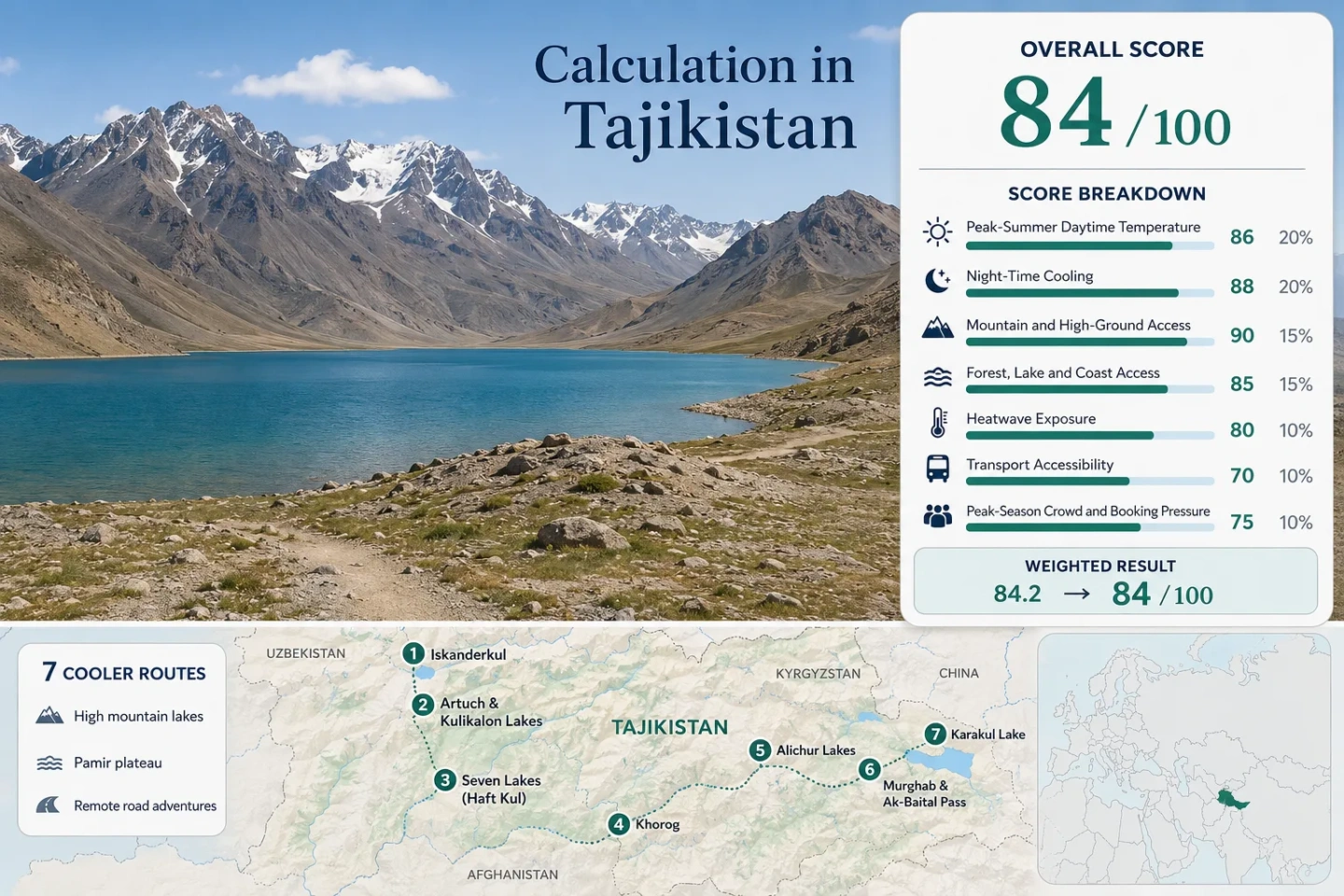
Three western lake routes and four Pamir Highway zones form one consistent map, score and comparison set.
Ak-Baital Pass creates the route’s sharpest altitude jump between Murghab and Karakul.
The high plateau combines very low modelled daytime averages with cold nights and extensive lake exposure.
The median supports strong overnight relief, although Alichur, Murghab and Karakul can become uncomfortably cold after sunset.
Low summer humidity and sparse cloud amplify solar exposure by day and radiative cooling at night.
Khorog, Alichur, Murghab and Karakul sit within GBAO, where permit status, road conditions and security advice can change.
Fann Lake Bases and the Eastern Pamir Road
The western cluster is reached from the Dushanbe–Panjakent corridor; the eastern cluster follows the long GBAO road through Khorog, Alichur, Murghab and Karakul. The separation matters because the two groups differ in acclimatization load, vehicle dependence and night-time cold.
Markers show selected cooler-route regions and planning centres, not guaranteed legal parking, trailheads or exact viewpoints. Use the place-specific Google Maps link and current local access information before travelling.
Tajikistan Pamir Cooler Escape Suitability Score
This transparent editorial suitability index uses disclosed climate, elevation, water access, transport and pressure factors. It is not an official climate classification or a weather forecast. The score represents only the seven mapped routes, not Tajikistan as a whole.
Weighted total: 100×0.25 + 65×0.20 + 100×0.15 + 75×0.15 + 100×0.10 + 40×0.10 + 60×0.05 = 81.3 → 81/100
Method: Route count does not add bonus points. Route-level values are combined using the median before the fixed weights are applied. Comparability quality is C because the climate inputs use heterogeneous place summaries and the heatwave factor uses a disclosed proxy rather than a common daily extraction.
High Lakes, Pass Roads and Cooler Night Bases
The portfolio deliberately mixes easier western approaches with remote Pamir Highway stages. The Fann routes offer shorter transfers and greener valleys; the eastern routes provide lower daytime heat but add altitude, permit and vehicle constraints.
Iskanderkul
Lake elevation: About 2,195 m. The July–August climate proxy averages roughly 21.5°C by day and 6.5°C at night, giving a milder daytime profile than the lowlands without the severe nocturnal cold of the eastern plateau.
The lake is reached from the Dushanbe–Panjakent corridor by a mountain road. It works as a shorter cool-air detour, but the lakeside has limited room inventory and little urban backup.
Artuch & Kulikalon Lakes
The Artuch base sits around 2,200 m, while the Kulikalon lake system is near 2,800 m. Published July–August proxies average about 15.8°C for daytime highs and 6.4°C for night-time lows.
The cooling advantage increases with every step above the base, but this is a hiking route rather than a roadside lake stay. Trail days, pack weight and acclimatization matter more than a nominal temperature number.
Seven Lakes / Haft Kul
Altitude ladder: The lake chain rises from roughly 1,640 m to about 2,400 m over more than 14 km. An unsurfaced road follows the gorge, so travellers can use elevation progressively rather than making one abrupt jump.
The score uses Panjakent’s warmer 28.1°C daytime and 15.8°C night proxy as a conservative lower gateway. Upper lakes should usually be cooler, but the route lacks a directly comparable published station series.
Khorog & Bartang Gateway
Khorog is the service hub rather than the coldest stop. Its July–August city proxy averages about 26.4°C by day and 8.7°C at night, while nearby Bartang and higher side valleys can reduce daytime heat as elevation increases.
Why it matters: This is the logical place to reset fuel, cash, food and vehicle plans before entering longer remote stages. Limited flight capacity and a very long overland approach keep accessibility below the western routes.
Alichur, Bulunkul & Yashilkul
Plateau level: Roughly 3,700–3,800 m. The modelled July–August profile is near 11.3°C by day and 2.5°C at night, making this the lowest-heat route in the set but also one of the least forgiving for sleep and acclimatization.
Bulunkul and Yashilkul add broad water surfaces to a dry, treeless plateau. The lakes soften the visual harshness, not the ultraviolet intensity or wind exposure.
Murghab & Ak-Baital Pass
Murghab sits near 3,600 m; Ak-Baital reaches 4,655 m. The settlement-scale July–August proxy is about 15°C by day and 2°C at night, while the pass can be colder, windier and physiologically harder than the town figure suggests.
Route function: Murghab is the eastern Pamir’s vehicle, fuel and guesthouse staging point. Ak-Baital is a transit exposure, not a sensible overnight base for most visitors.
Karakul Lake
Lake basin: About 3,914 m, reached after the Ak-Baital crossing. July–August proxies average around 16°C by day and 2.5°C at night, with exposed shores and little shelter from wind.
Karakul can feel calm in still sunshine and sharply cold once cloud, wind or darkness arrives. Accommodation is basic and limited, so low visitor numbers do not eliminate booking pressure.
Why the Eastern Pamir Loses Heat So Quickly
Alichur, Murghab and Karakul are not simply “cool mountains.” They form a high, arid plateau where low moisture, sparse vegetation and clear skies create a wide day–night temperature range.
Strong Sun Despite Low Air Temperature
At 3,600–3,900 m, an air temperature in the low teens can coexist with intense direct radiation. Dark vehicle interiors, exposed lake shores and windless stops may feel much warmer than the thermometer suggests.
Rapid Cooling after Sunset
Clear, dry air releases stored surface heat quickly. Alichur, Murghab and Karakul route proxies fall near 2–3°C at night, so insulated bedding and a windproof layer remain necessary in midsummer.
Dryness Can Hide Fluid Loss
Cool wind and fast evaporation reduce the sensation of sweating. Regular drinking, sun protection and slower walking matter even when the route never feels conventionally hot.
Khorog to Ak-Baital Is an Acclimatization Ladder, Not a Single Drive
The road’s cooling value rises with altitude, but so does physiological stress. Treating Khorog, Alichur, Murghab and Ak-Baital as interchangeable “Pamir stops” ignores a vertical gain of more than 2,500 metres.
Khorog: Around 2,100–2,200 m
A practical supply and recovery base. Nights are cooler than the lowlands, but daytime warmth remains possible and should not be mistaken for acclimatization failure.
Alichur: Around 3,700–3,800 m
The jump is large enough to affect sleep, appetite and walking pace. A slower approach through intermediate valleys is more prudent than racing directly from Khorog.
Murghab: Around 3,600 m
Services are better than at the lakes, but altitude remains substantial. A rest day here can be more valuable than adding another high pass to the schedule.
Ak-Baital: 4,655 m
The pass is a brief road crossing with little shelter. Symptoms that appear here should be treated as altitude signals, not simply cold-weather discomfort.
Which Tajikistan Route Matches the Cooling Trade-Off?
All seven mapped routes appear in the same comparison. Temperature values are historical or modelled July–August proxies, not forecasts; access classifications describe typical planning requirements rather than guaranteed road conditions.
| Route | Elevation Signal | July–August High / Low | Cooling Mechanism | Vehicle Dependence | Main Trade-Off |
|---|---|---|---|---|---|
| Iskanderkul | Lake base about 2,195 m | 21.5°C / 6.5°C | Lake basin plus elevation | Private or shared road transfer | Limited rooms and exposed midday sun |
| Artuch & Kulikalon Lakes | 2,200 m base; lake basin near 2,800 m | 15.8°C / 6.4°C | Elevation, lakes and juniper slopes | Road transfer plus hiking | Walking load and colder camps |
| Seven Lakes / Haft Kul | Rises from about 1,640 to 2,400 m | 28.1°C / 15.8°C at lower gateway | Progressive gorge elevation | Local vehicle on rough road | Warm lower approach and road dust |
| Khorog & Bartang Gateway | Hub around 2,100–2,200 m | 26.4°C / 8.7°C | Night cooling and higher side valleys | Long road or limited air service | Security changes and complex onward travel |
| Alichur, Bulunkul & Yashilkul | Plateau around 3,700–3,800 m | 11.3°C / 2.5°C | High plateau, dry air and lakes | Remote 4×4 route | Cold sleep conditions and acclimatization |
| Murghab & Ak-Baital Pass | 3,600 m town; 4,655 m pass | 15.0°C / 2.0°C at Murghab proxy | Extreme road elevation and dry air | Remote 4×4 route | Altitude load, fuel and sparse services |
| Karakul Lake | Lake basin about 3,914 m | 16.0°C / 2.5°C | High lake basin and night radiation | Remote high-road access | Wind exposure and basic accommodation |
GBAO Permits, Road Closures and Long Supply Gaps
The eastern routes cannot be planned like ordinary lake drives. Permit checks, temporary closures, border sensitivity and very limited rescue capacity can change the viability of Khorog, Bartang, Alichur, Murghab and Karakul even when the weather is stable.
Confirm the GBAO Permission before Departure
Foreign visitors normally need specific authorization for GBAO. A visa or visa-free entry status does not automatically settle every regional permit requirement, and authorities can suspend access at short notice.
Fuel, Cash and Communications Thin Out East of Khorog
Murghab is a critical resupply point, not a guarantee of full urban inventory. Carrying cash, drinking water, essential medication and a realistic fuel margin is more important than adding an extra viewpoint.
Do Not Build the Schedule around One Border Exit
Karakul often appears in through-routes toward Kyrgyzstan, but border and security arrangements can shift. A return option inside Tajikistan should remain feasible if an onward crossing becomes unavailable.
July and August Serve Different Pamir Decisions
Early July: Longer Light and More Snowmelt Influence
Long daylight supports slow road days and lake walks, while snowmelt can keep streams higher and rough-road sections less predictable. Western Fann routes may retain greener slopes than later in the season.
Late July: Strongest Vehicle and Bed Competition
The practical pressure point is often a shortage of suitable drivers, 4×4 vehicles and small guesthouse rooms rather than crowding at the landscape itself. Khorog and Murghab departures should be arranged before arrival.
August: Similar Daytime Cooling, Earlier Cold Evenings
Daytime conditions remain favourable for high-route heat avoidance, but shortening daylight makes late arrivals more consequential. Karakul and Alichur evenings can turn cold quickly once the sun drops behind the ranges.