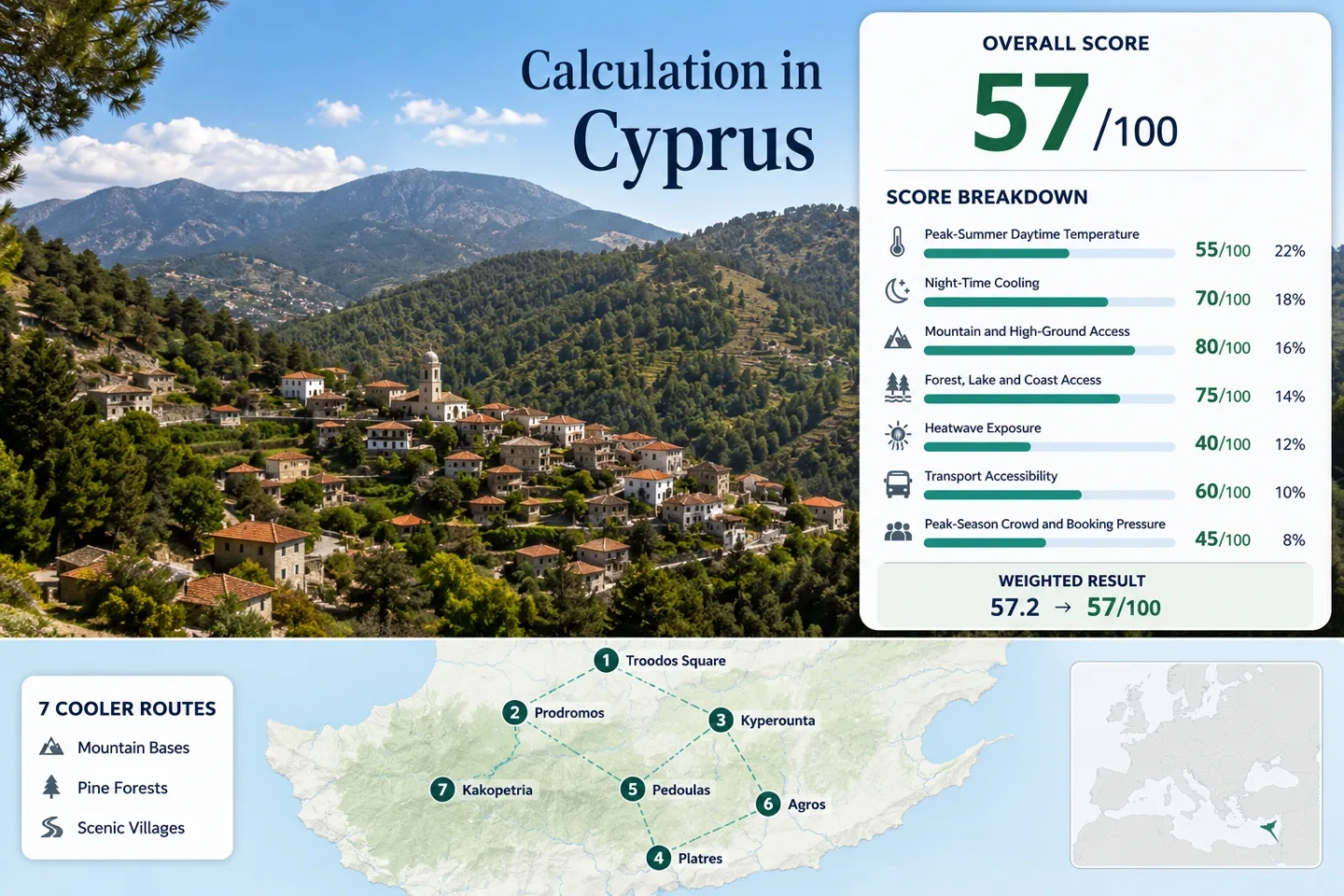
Cyprus Beyond the Coastal Heat: Troodos Villages, Pine Forests and Mountain Air
The Troodos range replaces Cyprus’s humid shoreline pattern with an inland altitude staircase: river villages begin near 670 metres, established mountain bases sit around 1,100–1,380 metres, and the road reaches Troodos Square at roughly 1,725 metres. Elevation, black-pine forest and cooler nights make the range a practical summer alternative, although July and August heat can still reach the highest villages during strong island-wide hot spells.
A 1,055-metre vertical range separates Kakopetria’s river setting from the Olympus ridge base.
The same seven places appear in the map, score evidence, route profiles and comparison matrix.
Cyprus’s Geological Survey uses this broad altitude relationship for the island’s mountain climate.
Its 1,725-metre base produces the lowest route-level night-temperature proxy in the selected set.
Most of Troodos Forest has National Forest Park status, with trails, picnic sites and camping areas.
Altitude reduces typical temperatures; it does not remove 30°C exposure during severe summer episodes.
From Solea Valley to the Olympus Ridge
The markers follow three distinct mountain approaches: Solea and Marathasa from the north and west, Pitsilia from the east, and the B8 ascent from Lemesos toward Platres and Troodos Square.
This marker map is built for planning orientation. Markers show selected mountain bases and approximate public location centres, not guaranteed legal parking, trailheads or exact viewpoints. Use each route card for Google Maps links and access notes before travelling.
Troodos Mountain Cooler Escape Suitability Score
This is a transparent editorial suitability index based on disclosed climate, landscape, access and pressure factors. It is not an official climate classification or a weather forecast.
Weighted total: 31×0.25 + 68×0.20 + 100×0.15 + 75×0.15 + 0×0.10 + 60×0.10 + 60×0.05 = 56.6 → 57/100
Method: Route count does not add bonus points. Each route carries equal weight; route-level values are combined using the median before the fixed factor weights are applied.
High Villages, Pine Slopes and River Valleys
The route set is intentionally vertical. Troodos Square and Prodromos prioritise altitude; Kyperounta, Platres, Pedoulas and Agros balance village services with 1,100-metre-plus bases; Kakopetria trades some temperature relief for river shade and easier lower-valley logistics.
Troodos Square and the Olympus Ridge
The clearest altitude choice begins at the square rather than in a resort village. The Atalanti circuit starts here and runs for about 14 km around the high forest, while nearby ridge roads reach still higher ground. The route-level climate proxy is the coolest in the set, but the 2020 heat block test still crossed the 30°C exposure threshold.
Prodromos Above the Marathasa Valleys
Prodromos sits at roughly 1,380 metres, close to the representative meteorological station used for the score. Its normal July–August proxy is 28.0°C by day and 18.0°C at night. The Prodromos–Zoumi trail works between about 1,300 and 1,500 metres, covers 6–6.2 km, and is officially described as most suitable from March through November.
The village is useful for a high overnight base with access toward Troodos Square, Pedoulas and the western forest roads. Local movement remains much easier with a car when several valleys are combined in one day.
Kyperounta and the Madari Side of Pitsilia
At approximately 1,300 metres, Kyperounta gives up little altitude to Prodromos while shifting the trip east toward Madari and the Pitsilia villages. The adjusted July–August proxy is 28.4°C maximum and 18.4°C minimum. Official access follows the B8 and the E801/E809/F946 sequence from the Lemesos side.
Mountain roads are winding, and crossing to Marathasa consumes more time than the short map distance suggests.
Platres, Cold River and the B8 Ascent
Platres is the most established hotel-style base in the selected set. Its advantage is not the lowest temperature; it is the combination of a 1,100-metre village, Cold River forest access and the Kalidonia corridor, with Troodos Square higher up the same road system.
Main trade-off: Accommodation choice and trail access are stronger than in smaller villages, but summer weekends can bring parking and booking pressure. Early starts matter on the narrow approaches to waterfall paths.
Pedoulas in the Marathasa Orchard Belt
The 1,100-metre base shares the 29.4°C daytime and 19.4°C night proxy assigned to the other villages at the same elevation, but its travel character is different. Pedoulas sits among orchards on the western side of the range and is reached through the E901, B9, E908 and F960 road sequence.
Public transport can cover parts of the valley, yet trailheads and cross-valley links remain car-dependent enough to reduce the accessibility score.
Agros Across the Pitsilia Slopes
Agros forms an amphitheatre-like settlement at about 1,100 metres, with a route proxy of 29.4°C by day and 19.4°C at night. It functions as a service base for the eastern Troodos villages rather than as a direct ridge trailhead.
Its location works particularly well when Kyperounta, Chandria and the Madari side are the priority. Reaching Platres, Prodromos or Kakopetria in the same day adds winding-road time, so east and west Troodos are better treated as separate loops.
Kakopetria at the Karkotis and Garillis Rivers
Kakopetria is the lower and warmer option: 670 metres, with an adjusted proxy of 31.6°C maximum and 21.6°C minimum. Its compensating feature is hydrology. The Karkotis and Garillis meet in the village to form the Klarios, while pine-covered Solea slopes rise toward higher Troodos roads.
Agios Nikolaos tis Stegis is about 5 km away, and the settlement has a broader visitor-service base than many high villages. That makes it useful for mixed-interest trips, not for the lowest possible daytime heat.
The 1,055-Metre Temperature Staircase
The selected bases are not one climate zone. Their vertical separation changes afternoon exposure, overnight relief and the distance required to reach shaded high forest.
Ridge Band: 1,700 Metres and Higher
Troodos Square starts where several villages finish their day trips. The proxy is roughly 3–5°C lower by day than the 1,100-metre and 670-metre bases, and ridge trails can be reached without a long morning climb.
High-Village Band: 1,100–1,380 Metres
Prodromos and Kyperounta retain the strongest night advantage; Platres, Pedoulas and Agros add more accommodation or village services. The deciding issue is often valley position, not a small elevation difference.
Solea River Band: About 670 Metres
Kakopetria relies on river shade, trees and access to higher roads. It remains a mountain settlement, yet the score proxy places its typical day and night temperatures much closer to inland summer heat.
B8, Marathasa and Pitsilia Create Different Trips
B8: Platres to the Ridge
The Lemesos approach climbs through Platres toward Troodos Square. It is the most direct pairing for Cold River, Kalidonia and ridge trails, but popular nodes concentrate traffic on summer weekends.
Marathasa: Prodromos and Pedoulas
Western valleys favour a loop built around Prodromos and Pedoulas. Steep bends and short straight-line distances make daily cross-range itineraries slower than their map spacing suggests.
Pitsilia: Kyperounta and Agros
The eastern villages work as their own overnight circuit. Kyperounta offers the higher base; Agros contributes more services and a practical centre for surrounding Pitsilia roads.
Practical split: A short stay is usually more coherent when it chooses one side of the range. Combining Solea, Marathasa and Pitsilia in a single day replaces cool-air time with repeated mountain-road transfers.
Temperature, Access and Shade Across All Seven Bases
Temperature values are the disclosed representative-station proxies used in the score, not local forecasts. The access column reflects the route-level transport rubric.
| Route | Base elevation | July–August max / min proxy | Transport score | Cooling asset | Main constraint |
|---|---|---|---|---|---|
| Troodos Square | 1,725 m | 26.3°C / 16.3°C | 40/100 | Immediate ridge forest | Day-use pressure and exposed trails |
| Prodromos | 1,380 m | 28.0°C / 18.0°C | 40/100 | High village plus reservoir corridor | Car-useful cross-valley movement |
| Kyperounta | 1,300 m | 28.4°C / 18.4°C | 60/100 | High Pitsilia base near Madari | Longer transfer to western valleys |
| Platres | 1,100 m | 29.4°C / 19.4°C | 60/100 | Cold River and forest trails | Weekend parking and booking pressure |
| Pedoulas | 1,100 m | 29.4°C / 19.4°C | 40/100 | Marathasa orchards and woodland | Multi-road access sequence |
| Agros | 1,100 m | 29.4°C / 19.4°C | 60/100 | Eastern mountain slopes | Distance from ridge trailheads |
| Kakopetria | 670 m | 31.6°C / 21.6°C | 60/100 | River confluence and pine valley | Less night-time relief |
Choose the Base by the Kind of Relief Needed
Lowest-Heat Base
Troodos Square has the highest sleeping elevation and the lowest disclosed temperature proxy. It suits ridge walking and short stays where village nightlife is not the priority.
Village-Service Balance
Kyperounta or Platres works better when restaurants, accommodation and nearby walks matter alongside altitude. Kyperounta is higher; Platres has denser visitor infrastructure.
River-Shade Base
Kakopetria offers the strongest river setting and convenient Solea positioning, but its 670-metre elevation means warmer afternoons and nights than the high-village band.
July Heat, August Pressure and the September Shift
Late June to Early July
Long daylight supports ridge walks and cross-valley drives. The highest bases offer the clearest thermal margin, while lower river villages can already run hot in the afternoon.
Mid-July through August
Altitude remains useful, but official reports show that severe island heat can reach Prodromos. Begin exposed trails early, preserve a forested fallback, and avoid treating a mountain address as a heat guarantee.
September Road and Trail Balance
Night relief generally improves while the March–November trail season around Prodromos remains open. The trade-off is shorter daylight rather than summer road closure.
Before departure: Check the Cyprus Department of Meteorology forecast, the official journey planner, forest-fire restrictions and any trail or road notices. Mountain conditions can change faster than coastal booking plans.