Italy Without the Summer Burn: Dolomites, Alpine Lakes and High Villages
Northern Italy’s cooler summer options depend on elevation rather than the country’s national temperature average. Dolomite villages above 1,100 metres, rail-served valleys near the Austrian border and lake bases beneath high limestone ranges create distinctly different comfort patterns. Livigno and the upper Dolomite valleys provide the lowest daytime heat exposure, while Molveno offers easier lake access with warmer afternoons and milder nights.
Four Dolomite valley bases, two high Lombardy towns and one Brenta Dolomites lake base.
The route set remains well above the hotter Po Valley and lower Adige corridor.
A village elevation near 1,816 metres produces the route set’s clearest daytime and night-cooling advantage.
The Puster Valley railway reaches the village directly, with regional buses extending into nearby valleys.
Livigno combines a high reservoir with cool nights; Molveno provides easier swimming access but warmer afternoons.
Afternoon thunderstorms, lift timetables, pass-road traffic and lake parking pressure can change the practical route.
Dolomite Valleys, Alpine Lakes and High-Village Bases
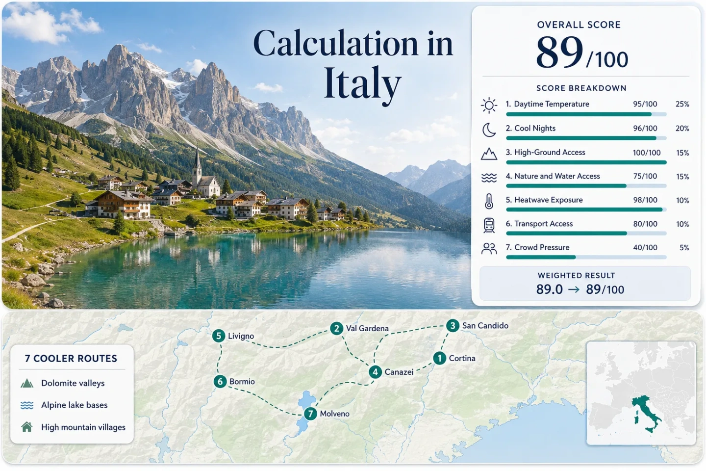
The markers identify the seven accommodation bases used throughout the score and comparisons. They are planning centres rather than exact viewpoints, trailheads or legal parking locations.
Marker positions use approximate public settlement centres. Check each route’s current transport, parking, lift and trail information before travelling.
Italy Alpine Cooler Escape Suitability Score
This transparent editorial suitability index uses disclosed climate, landscape, access and peak-pressure factors. It is not an official climate classification, safety rating or weather forecast.
Weighted total: 95×0.25 + 96×0.20 + 100×0.15 + 75×0.15 + 98×0.10 + 80×0.10 + 40×0.05 = 89.0 → 89/100
Method: Route count does not add bonus points. Each route carries equal weight, route-level values are combined using the median and the seven fixed factor weights are then applied.
Dolomite Valleys, Alpine Lakes and High-Village Routes
The seven bases cover different versions of a northern Italian coolcation: lift-served Dolomite villages, a railway valley, very high Lombardy settlements and an alpine lake below the Brenta Dolomites.
Cortina d’Ampezzo and Its High Dolomite Basin
Cortina sits at roughly 1,224 metres, with a representative July–August daytime maximum near 22.4°C and an average minimum near 10.5°C. Forest roads, the Falzarego corridor and lift-served terrain provide rapid elevation changes without changing accommodation base.
Ortisei and the Lift-Served Val Gardena Slopes
Ortisei combines a village elevation near 1,236 metres with bus access from the main Adige rail corridor. Its representative peak-summer values are approximately 22.0°C by day and 9.5°C at night, although the Selva di Val Gardena reference station is higher than the town centre.
The practical cooling advantage comes from reaching Seceda, Alpe di Siusi and Resciesa without driving a mountain pass. Lift operating hours, rather than road distance, set the daily rhythm.
San Candido as a Puster Valley Rail Base
Direct regional rail access distinguishes San Candido from most Dolomite resorts. The village stands near 1,175 metres, while nearby Dobbiaco station provides a close official climate reference with representative July–August values near 21.5°C by day and 8.5°C at night.
Lake Dobbiaco, the Innichen–Lienz cycle corridor and buses toward Sesto create several car-light day structures. Pressure increases when Three Peaks access traffic spills into the wider valley.
Canazei Beneath the Sella and Marmolada Corridors
Canazei’s accommodation base is close to 1,465 metres, placing it among the higher major villages in the route set. Representative peak-summer values are near 21.0°C for average daily maxima and 8.0°C for minima.
Local lifts reduce the need to chase altitude by car, while scheduled buses connect the Fassa villages. Arrival from a major rail station generally takes longer than the South Tyrol railway routes.
Livigno’s High Valley and Lake-Edge Air
At approximately 1,816 metres, Livigno has the highest accommodation base in the portfolio. The representative July–August profile is close to 20.0°C by day and 7.0°C at night, with very limited 30°C threshold exposure.
Lake Livigno adds open water and exposed valley air, although the water does not imply a warm swimming season. The longer approach from Tirano or through Alpine road corridors is the central trade-off.
Bormio Between the Adda Valley and Stelvio High Roads
Bormio stands near 1,225 metres and is warmer than Livigno despite a similar regional setting. Representative July–August values reach about 24.0°C by day and 11.5°C at night, leaving more potential for hot afternoons in the town basin.
Scheduled buses connect Bormio with Tirano, but road events, cycling traffic and pass closures can alter travel times. The town is a balanced option when services matter as much as the lowest possible temperature.
Molveno’s Lake Shore Beneath the Brenta Dolomites
Molveno is the lowest base in the set at roughly 864 metres. Its representative July–August averages are correspondingly warmer, near 25.2°C by day and 13.0°C at night.
The reason to choose Molveno is not the lowest thermometer reading. It is the combination of a large swimmable lake, forested shores and quick access toward the Pradel plateau and Brenta trails.
Lift Hours and Pass Roads Change the Cooling Range
Ortisei, Canazei and Cortina Without Daily Pass Driving
Ortisei and Canazei can shift a summer day from a village base above 1,200 metres to much higher walking terrain by lift. Cortina provides a similar altitude range through several separate lift sectors. The advantage is strongest when accommodation is close to the operating lift or a frequent connecting bus.
Bormio’s Road-Led Altitude Access
Bormio’s major cooling range is tied more closely to the Stelvio and Gavia road systems. This creates exceptional vertical variation but also exposes the day to cycling events, temporary closures, congestion and rapidly changing high-pass weather.
San Candido’s Railway-Valley Strategy
San Candido does not need a lift or pass road for every cooler outing. The Puster Valley railway and connecting buses allow movement between high settlements while preserving a car-light itinerary, especially for cycling and valley-lake days.
Livigno and Molveno Separate Lake Access from Swimming Comfort
Livigno: Lower Air Temperatures, Colder Water
Livigno’s 1,816-metre elevation gives it the stronger heat buffer and colder nights. The reservoir contributes open-water exposure and a spacious valley landscape, but swimming is not the route’s main comfort advantage. Air temperature and altitude are the deciding variables.
Molveno: Warmer Air, Broader Swimming Window
Molveno sacrifices some daytime cooling in exchange for a more practical beach-and-swimming structure. A hot afternoon can still occur at the lakeshore, so the cooler pattern depends on forest shade, water contact and movement toward Pradel rather than elevation alone.
Which Italian Alpine Base Fits Each Summer Priority?
All seven mapped routes are compared using the factors that most directly affect a July–August decision.
| Route | Base Elevation | Lowest-Heat Strength | Car-Light Access | Water or Forest Access | Main Peak-Season Trade-Off |
|---|---|---|---|---|---|
| Cortina d’Ampezzo | About 1,224 m | Strong | Moderate | Forest and alpine lakes | Pass-road traffic and constrained parking |
| Ortisei and Val Gardena | About 1,236 m | Strong | Strong | Extensive forest and lift-served meadows | Accommodation and lift demand |
| San Candido | About 1,175 m | Strong | Very strong | Forest, cycle routes and nearby lakes | Three Peaks corridor pressure |
| Canazei | About 1,465 m | Very strong | Moderate | Forested valley and high lift terrain | Sella Pass congestion |
| Livigno | About 1,816 m | Very strong | Limited to moderate | Large reservoir and high valley | Longer arrival chain |
| Bormio | About 1,225 m | Moderate | Strong after Tirano | Forest and upper Adda valley | Events and high-pass road conditions |
| Molveno | About 864 m | Moderate | Strong | Large lake and Brenta forest slopes | Lakeshore parking and warmer afternoons |
Heat, Swimming and High-Ground Access Peak at Different Times
Late June for Lower Pressure
Late June can reduce accommodation and pass-road pressure, but some high lifts, seasonal buses and upper trails may still be operating on partial schedules. Residual snow can remain on shaded high routes.
July to Mid-August for Full Access
The broadest lift, bus and mountain-hut network normally operates during this period. It is also the most exposed to school-holiday demand, parking controls and afternoon thunderstorms.
Late August for Cooler Nights
Night cooling often strengthens toward the end of August while most summer infrastructure remains available. Lake swimming conditions may remain usable at Molveno even as morning temperatures fall in Livigno and the higher Dolomite villages.
Forecasts, Lift Status and Pass Roads Need a Final Check
Mountain comfort can change within hours. Review official forecasts for thunderstorms and heat alerts, confirm lift and regional-bus timetables, and check pass-road restrictions before committing to a high route. A village temperature is not a substitute for trail-level conditions, especially above the tree line or near exposed limestone plateaus.