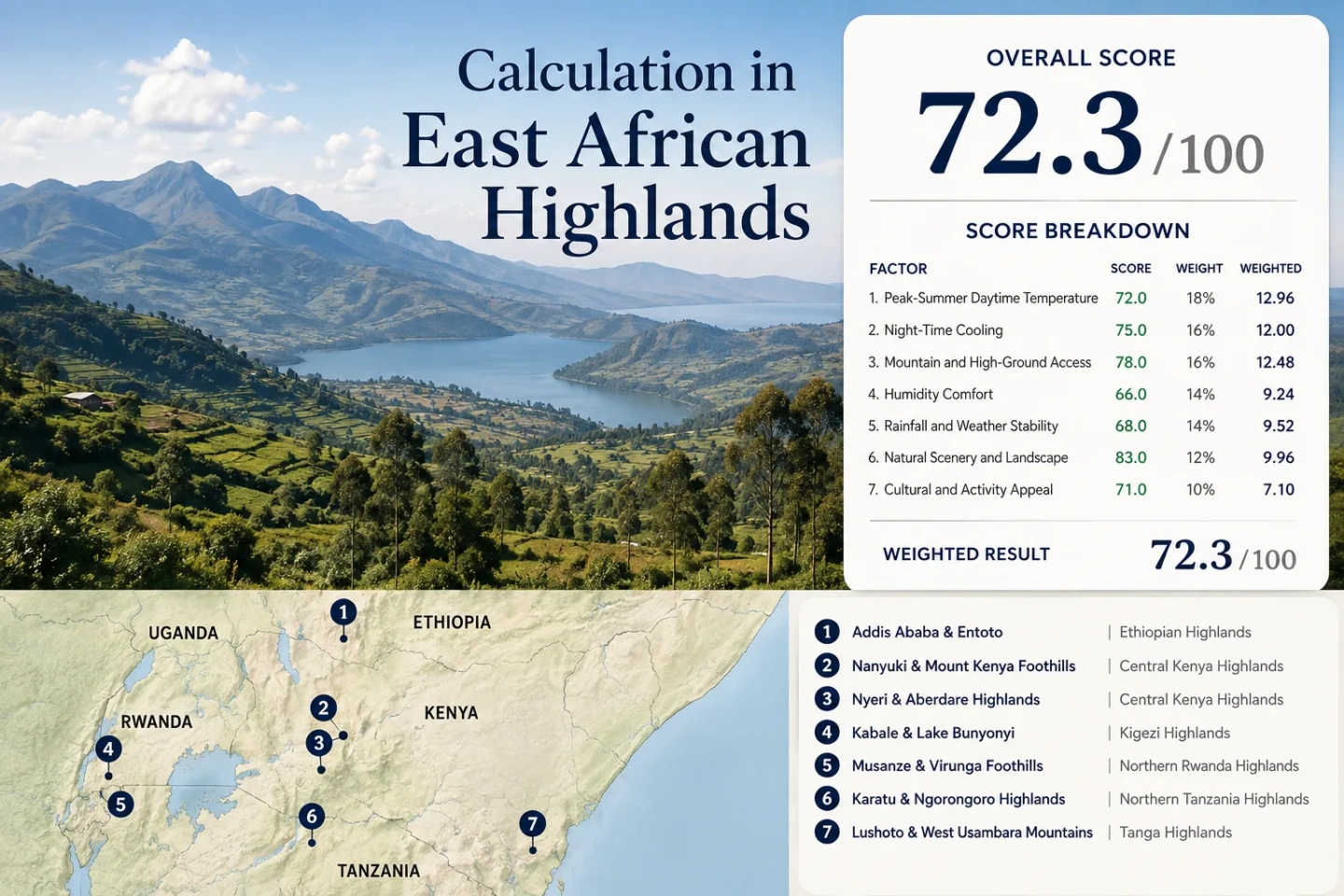
East African Highlands for Cooler Travel
East Africa is not uniformly hot at tropical latitudes. Addis Ababa sits above 2,300 metres, Nanyuki is close to 1,950 metres on the Mount Kenya flank, and Kabale, Musanze, Karatu and Lushoto occupy highland belts where July–August nights are commonly far cooler than nearby lowlands. The useful distinction is not simply high versus low elevation. Sleeping altitude, daytime high-ground access and rainfall season have to line up. Addis is cool in July and August but deep in its wet season; central Kenya, northern Rwanda and much of northern Tanzania usually gain a drier highland window at the same time.
Urban plateau, mountain foothill, lake highland, volcanic and escarpment bases across Ethiopia, Kenya, Uganda, Rwanda and Tanzania.
Lushoto anchors the lower end; Addis Ababa is the highest regular city base in the set.
Median of published route-level July–August maximum-temperature values; source periods differ by location.
Nanyuki is near the cold end of the set, while Lushoto has the mildest published night signal.
Its published July–August normal is far wetter than the other selected bases, making cool air and dry weather separate decisions.
Highland Bases From Addis Ababa to the Usambaras
The route set follows practical accommodation bases rather than summits. Markers use approximate public location centres for planning orientation; they are not trailheads, legal parking points or exact park entrances.
Markers show selected highland bases and planning centres. Use the named location link in each route entry for navigation and check local road or park access before a high-ground excursion.
Plateau Cities, Lake Highlands and Mountain Foothills
Each base offers a different way to reduce heat exposure: very high urban elevation, cold nights, montane forest, a high-altitude lake, volcanic slopes or a lower town with easy access to terrain above 2,000 metres.
Addis Ababa and Entoto
Approximate city elevation: 2,355 m. Published WMO climate values for July and August are about 21°C for the mean daily maximum and 10°C for the mean daily minimum. The same two months carry roughly 570 mm of precipitation in the published normal, so low temperatures arrive with persistent wet-season weather.
Entoto rises above the city and adds forest, cloud and colder air without requiring a change of accommodation. That makes Addis unusually strong for altitude-based cooling, but July–August visibility and walking conditions are less dependable than the temperature alone suggests.
Nanyuki and the Mount Kenya Foothills
Nanyuki Municipality places the town at about 1,947 m above sea level, high enough for a distinctly cooler equatorial climate. Published local July–August values are about 22.5°C by day and near 8°C at night, giving this route one of the sharper day-to-night drops in the set.
The town works as a services base while the Mount Kenya approaches add still higher terrain during the day. July and August rainfall figures in local planning material total roughly 135 mm, far below Addis for the same two-month window, although the underlying observation period is not a modern common regional normal.
Nyeri and the Aberdare Highlands
The Kenya Meteorological Department lists Nyeri station at 1,768 m. Published July–August climate values are around 20.6°C for daytime maxima and 12°C for minima, with roughly 64 mm of precipitation across the two months.
Nyeri differs from Nanyuki even though the two bases are relatively close. The Aberdare side is greener and more forest-influenced, so cloud, mist and damp road conditions can matter more than on the open Mount Kenya plateau. Town access is straightforward; forest and park sectors usually require more deliberate road planning.
Kabale and Lake Bunyonyi
Sleeping elevation is roughly 1,950–2,000 m around Kabale and Lake Bunyonyi. Published Kabale climate normals put July–August maxima near 24.1°C and minima near 9.6°C, with about 74 mm of precipitation across the two months.
Lake Bunyonyi is not a lowland tropical lake cooled only by breeze; the lake surface itself is high. The surrounding Kigezi hills add short vertical changes, cold-air drainage into valleys and cool early mornings. July is notably drier than the main rainy periods, while August begins to pick up more rain.
Musanze and the Virunga Foothills
Current district planning documents place Musanze's urban terrain around 1,835 m, while the wider volcanic plain averages close to 1,886 m. A 1991–2020 gridded climatology gives July–August maxima near 22.8°C, minima near 10.9°C and about 98 mm of precipitation.
The base forecast should not be used as a mountain-slope forecast. Virunga terrain rises quickly above Musanze, where cloud, wind and rain can become more pronounced even when the town is dry. Kigali-to-Musanze road access is much simpler than high-slope park logistics.
Karatu and the Ngorongoro Highlands
Karatu sits at roughly 1,500 m, while commonly visited Ngorongoro rim terrain rises above 2,000 m. Published 1991–2021 climatology for Karatu gives a July–August average maximum near 21°C, a minimum near 11.4°C and only about 59 mm of rainfall across the two months.
This is a two-level cooling pattern: accommodation can remain at the milder lower base while daytime travel reaches a much colder, windier rim. That separation is useful for travellers who do not want every night at the highest elevation.
Lushoto and the West Usambara Mountains
Lushoto is around 1,400 m, with published 1991–2021 July–August values near 21.4°C by day, 14.2°C at night and about 86 mm of rainfall. Lushoto District's own agro-ecological description places colder nearby uplands such as Mtae and Upper Mlalo around 1,700–2,100 m.
That creates a useful coastal-to-highland contrast in northeastern Tanzania: a relatively moderate town base, forested ridges and higher villages reachable without using an alpine destination. The night signal is milder than Nanyuki or Kabale, which can suit travellers who want relief from coastal heat without very cold mornings.
Seven Highland Bases on the Same Travel Questions
The climate values come from published station, municipal or gridded climatologies with different reference periods. They are useful for route planning, but they are not a synchronized regional normal. Elevation and rainfall figures are therefore better read as decision ranges than as a precision ranking.
| Highland base | Approx. sleeping elevation | Published Jul–Aug max / min | Jul–Aug precipitation signal | Higher-ground extension | Main trade-off |
|---|---|---|---|---|---|
| Addis Ababa & Entoto | ~2,355 m | 21.0°C / 10.0°C | ~570 mm | Entoto above the city | Very cool, but deep wet season |
| Nanyuki & Mount Kenya Foothills | ~1,947 m | 22.5°C / ~8.0°C | ~135 mm | Mount Kenya approach terrain | Cold nights; mountain sectors need separate access planning |
| Nyeri & Aberdare Highlands | 1,768 m station | 20.6°C / 12.0°C | ~64 mm | Aberdare forest and higher roads | Mist and damp forest conditions |
| Kabale & Lake Bunyonyi | ~1,950–2,000 m | 24.1°C / 9.6°C | ~74 mm | Kigezi hills around the lake | Warmer afternoons than Nyeri; colder nights |
| Musanze & Virunga Foothills | ~1,835 m urban base | 22.8°C / 10.9°C | ~98 mm | Virunga volcanic slopes | Town weather changes quickly with elevation |
| Karatu & Ngorongoro Highlands | ~1,500 m | 21.0°C / 11.4°C | ~59 mm | Ngorongoro rim above 2,000 m | Road-based access; colder foggier rim |
| Lushoto & West Usambara Mountains | ~1,400 m | 21.4°C / 14.2°C | ~86 mm | Mtae / Upper Mlalo 1,700–2,100 m | Milder nights; higher villages add cooling |
July–August Separates Addis From the Rift-Side Highlands
Addis Ababa demonstrates why latitude alone is a poor season marker in East Africa. Its published July and August rainfall values are roughly 280 mm and 290 mm. The temperature is low, but the Kiremt rains dominate the travel experience. Nyeri's corresponding published values are about 30 mm and 34 mm; Kabale moves from roughly 20 mm in July to 54 mm in August; Musanze rises from about 33 mm to 65 mm.
Addis: Cool Air With Kiremt Rain
July–August daytime maxima near 21°C are attractive for heat avoidance, but frequent rain, saturated ground and cloud reduce the value of high viewpoints and long walking days. The thermal advantage is real; the dry-weather advantage is not.
Central Kenya: Drier Air at Similar Temperatures
Nyeri and Nanyuki keep high-elevation temperatures while July–August rainfall is much lower than Addis in their published datasets. Nyeri is the cooler daytime option; Nanyuki pushes harder on night cooling and Mount Kenya access.
Rwanda and Northern Tanzania: Dry-Season Alignment
Musanze, Karatu and Lushoto combine highland air with a relatively dry mid-year period. Karatu has the lightest two-month precipitation signal in the selected set, while Musanze gains the stronger volcanic-elevation contrast.
Sleeping Elevation and Day-Trip Elevation Are Different Decisions
A mountain name can make a route appear colder than the place where a traveller actually sleeps. Accommodation elevation is the overnight climate anchor. High-ground excursions then add a second temperature layer.
Addis and Nanyuki Start High
Addis begins above 2,300 m and Nanyuki near 1,950 m. Neither route depends on a summit day to produce cool nights. Entoto and Mount Kenya approaches extend the range upward rather than creating the entire cooling effect.
Karatu Uses a Two-Level Highland Pattern
Karatu's roughly 1,500 m base is milder overnight, while the Ngorongoro rim moves the daytime route above 2,000 m. A cold, foggy rim does not mean the hotel base will have the same temperature.
Lushoto Adds Altitude Through the West Usambaras
Lushoto stays in a moderate highland band, then nearby Mtae and Upper Mlalo climb to roughly 1,700–2,100 m. That lets a traveller choose between milder nights in town and colder daytime terrain farther along the escarpment.
Cold Nights Change the Lodging Decision
The route-set daytime median is around 21.4°C, but the more useful overnight difference is wider. Nanyuki's published July–August minima sit around 8°C, Kabale near 9.6°C, Addis near 10°C and Musanze near 10.9°C. Lushoto is milder at roughly 14.2°C. A traveller trying to avoid hot bedrooms may value that night spread more than a one- or two-degree daytime difference.
Nanyuki and Kabale Push Hardest on Night Cooling
Nanyuki couples an already high town elevation with very cool published minima. Kabale adds a high lake and valley topography. Both can produce mornings that call for a layer even when afternoons remain comfortable.
Lushoto Keeps the Night Signal Milder
Lushoto still removes much of the heat associated with Tanzania's lower eastern areas, but its July–August minima are several degrees warmer than Nanyuki or Kabale. That is useful when the goal is cooler travel without the coldest early-morning conditions.
Where Cool Air and Usable Weather Overlap
For a July–August trip, the clearest temperature-versus-rain trade-off sits in the Kenya, Rwanda and northern Tanzania highlands. Nyeri pairs low daytime maxima with moderate mid-year rainfall; Nanyuki adds colder nights; Musanze combines volcanic elevation with its drier part of the year; Karatu offers a mild base and a colder rim; Lushoto provides a softer highland alternative with higher villages nearby. Addis remains the highest urban cooling option in the set, but its mid-year rain regime changes the type of trip. Kabale sits between these patterns, with very cool nights and a drier July followed by a wetter August.
Mountain access should be checked independently from town weather. Mount Kenya, Aberdare, Virunga and Ngorongoro sectors can have gate, road, cloud or visibility conditions that are not reflected in the nearest accommodation-base forecast.