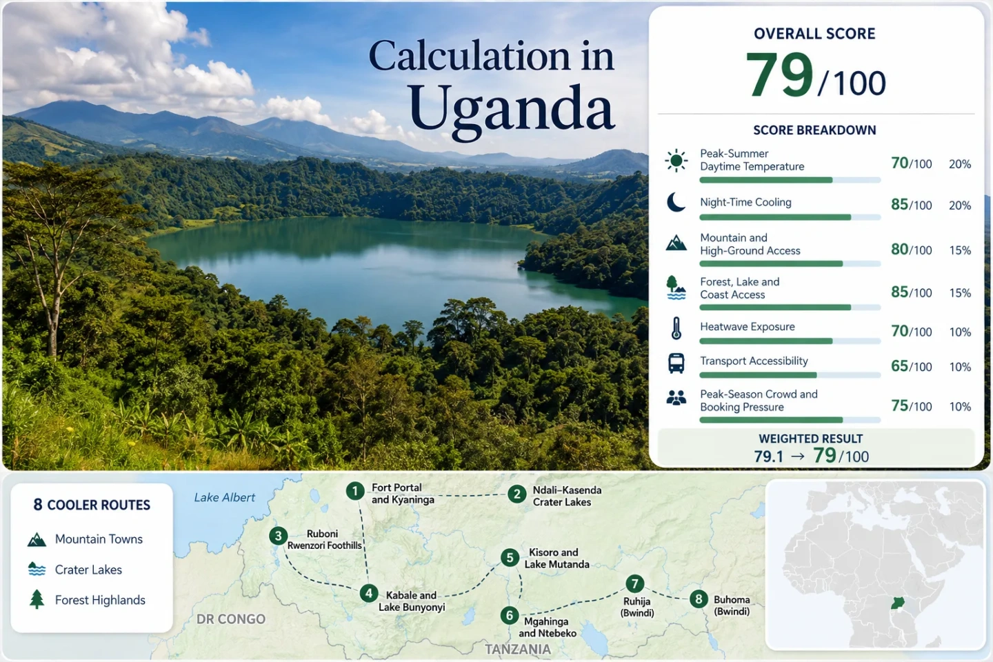
Uganda Highland Escapes: Crater Lakes, Mountain Forests and Cool Western Towns
Western Uganda’s more convincing cool-air routes are defined by elevation rather than longitude. Fort Portal provides an accessible upland city base, the Ndali–Kasenda belt adds crater-rim airflow, Ruboni sits beneath the Rwenzori’s forested slopes, and the Kabale–Kisoro corridor reaches much higher ground around Lake Bunyonyi, Lake Mutanda, Mgahinga and the upper sectors of Bwindi. The result is not one uniform highland climate but a sequence of cooler nights, shaded mountain forests, exposed lake ridges and rain-sensitive roads.
The same eight areas are used in the marker map, suitability calculation, destination profiles and comparison matrix.
A relatively dry and cool equatorial window, although mountain forests can still produce rain, mist and wet ground.
Representative July–August daily maximum values range from about 20°C at Ntebeko to roughly 25°C around Fort Portal.
Kabale, Kisoro, Mgahinga and the higher Bwindi sectors provide the clearest evening and early-morning cooling.
The assessed accommodation and visitor bases begin above the hotter rift floor and extend to Ntebeko at the lower edge of Mgahinga.
The stronger highland climates generally require longer transfers, private road transport or a rain-sensitive final approach.
Crater Rims, Rwenzori Slopes and Southwestern Highland Bases
The route set follows two connected highland systems: Fort Portal and the Rwenzori foothills in the west, then the higher Kabale–Kisoro–Bwindi arc in the southwest. The lower Albertine Rift floor is deliberately excluded because proximity to mountains does not automatically produce a cool accommodation base.
Markers show selected cooler-route regions and planning centers, not guaranteed legal parking, trailheads or exact viewpoints. Use the destination-specific Google Maps links and confirm the final road, park gate and accommodation approach before traveling.
Uganda Western Highland Cooler Escape Suitability Score
This transparent editorial suitability index applies the same seven climate, landscape, access and pressure factors used across Cooler Escapes. It is not an official climate classification, a destination guarantee or a short-range weather forecast.
Method: Median of representative July–August mean daily maximum temperatures for the eight route areas, followed by the fixed site-wide temperature normalization.
Raw median: 23.8°C.
Route values: Fort Portal and Kyaninga 25.3°C; Ndali–Kasenda 24.6°C; Ruboni 24.0°C; Kabale and Lake Bunyonyi 23.5°C; Kisoro and Lake Mutanda 23.5°C; Mgahinga and Ntebeko 20.0°C; Ruhija 22.5°C; Nkuringo 24.2°C.
Climate mapping: Fort Portal uses a published Fort Portal locality climatology. Kabale uses the WMO-listed Kabale climate location and highland locality material. Kisoro and Nkuringo use published locality climatologies. Ruboni, Ntebeko and Ruhija use disclosed lower-mountain or sector-level temperature ranges because directly comparable official normals are not published for every visitor base.
Data periods: Source periods vary by location; long-term climate tables are preferred, while shorter Copernicus-based locality summaries are treated as representative proxies rather than equivalent official stations.
Sources: WMO World Weather Information Service — Kabale; Fort Portal locality climate table; Kisoro locality climate table; Nkuringo locality climate table; Uganda Wildlife Authority — Mgahinga altitude context.
Method: Median of representative July–August mean daily minimum temperatures. The site-wide maximum score applies when the route median remains between 10°C and 16°C, the preferred range for useful night relief without routinely severe cold at accommodation level.
Raw median: 13.7°C.
Route values: Fort Portal and Kyaninga 15.1°C; Ndali–Kasenda 14.7°C; Ruboni 15.0°C; Kabale and Lake Bunyonyi 12.5°C; Kisoro and Lake Mutanda 13.5°C; Mgahinga and Ntebeko 10.0°C; Ruhija 11.5°C; Nkuringo 13.8°C.
Interpretation: Fort Portal offers moderate night relief, while Ntebeko, Ruhija, Kabale and Kisoro require a more deliberate evening layer. Summit and alpine temperatures are excluded because they do not represent ordinary lodge or town conditions.
Data periods: The same disclosed locality climatologies and highland-sector proxies used for the daytime factor.
Sources: NASA POWER climatology service documentation; WMO World Weather Information Service — Kabale; Nkuringo locality climate table; Uganda Wildlife Authority — Mgahinga park brochure.
Method: Fixed categorical rubric based on the elevation of the accommodation base or regular access to ground above 1,500 metres within about 60 minutes.
Route scores: Fort Portal and Kyaninga 100; Ndali–Kasenda 100; Ruboni 100; Kabale and Lake Bunyonyi 100; Kisoro and Lake Mutanda 100; Mgahinga and Ntebeko 100; Ruhija 100; Nkuringo 100.
Median: 100/100.
Route basis: Every assessed base is either already high enough to meet the upper rubric or provides immediate access to substantially higher mountain terrain. Ntebeko lies at the lower edge of a park extending from 2,227 to 4,127 metres, while 70% of Rwenzori Mountains National Park lies above 2,500 metres.
Data period: Access and park geography reviewed July 2026.
Sources: Uganda Wildlife Authority — Rwenzori Mountains; UNESCO — Rwenzori Mountains National Park; Uganda Wildlife Authority — Mgahinga Gorilla National Park; UNESCO — Bwindi Impenetrable National Park.
Method: Fixed access rubric measuring whether a route reaches a substantial forest, lake or river system within approximately 30 minutes. Landscape appearance alone does not earn points.
Route scores: Fort Portal and Kyaninga 75; Ndali–Kasenda 100; Ruboni 100; Kabale and Lake Bunyonyi 75; Kisoro and Lake Mutanda 100; Mgahinga and Ntebeko 100; Ruhija 75; Nkuringo 75.
Raw median: 87.5/100, displayed as 88/100.
Route basis: Ndali–Kasenda combines crater lakes with forested slopes; Ruboni combines Rwenzori forest and mountain rivers; Kisoro links Lake Mutanda with Virunga forest access; and Ntebeko begins directly beside Mgahinga’s montane and bamboo vegetation.
Data period: Park and route access reviewed July 2026.
Sources: Uganda Wildlife Authority — Rwenzori landscape; Uganda Wildlife Authority — Mgahinga forest; Uganda Wildlife Authority — Bwindi forest; Uganda Wildlife Authority — Ntebeko, Kisoro and Lake Mutanda access context.
Method: Proxy threshold class based on published highland daily-maximum envelopes and Copernicus- or reanalysis-supported locality summaries where a complete official 30°C exceedance series is not available for the route base.
Raw result: The route median falls in the fixed 0–1% proxy class for July–August days reaching at least 30°C.
Route threshold classes: Fort Portal and Kyaninga ≤1%; Ndali–Kasenda ≤1%; Ruboni ≤1%; Kabale and Lake Bunyonyi ≤1%; Kisoro and Lake Mutanda ≤1%; Mgahinga and Ntebeko ≤1%; Ruhija ≤1%; Nkuringo ≤1%.
Limitation: These are disclosed proxy classes rather than equivalent official station exceedance counts. The high score should not be interpreted as a guarantee against an unusually hot afternoon, direct sun exposure or future climate extremes.
Data period: Published historical locality summaries available through July 2026; shorter products are treated as lower-comparability evidence.
Sources: NASA POWER daily data methodology; NASA POWER climatology methodology; Fort Portal historical temperature envelope; Kisoro locality climate table; Nkuringo locality climate table.
Method: Fixed route-access rubric considering long-distance public transport, private-vehicle dependence, final-road complexity and the number of difficult connections.
Route scores: Fort Portal and Kyaninga 60; Ndali–Kasenda 40; Ruboni 40; Kabale and Lake Bunyonyi 40; Kisoro and Lake Mutanda 40; Mgahinga and Ntebeko 20; Ruhija 20; Nkuringo 20.
Median: 40/100.
Route basis: Fort Portal, Kabale and Kisoro can be reached by long-distance road transport, but crater lakes, lake accommodation, mountain gates and upper Bwindi sectors commonly require a hired vehicle, arranged transfer or local connection. UWA places Ntebeko about 14 km from Kisoro and Lake Mutanda about 30 km from Ntebeko, illustrating why short map distances do not remove the final-transfer issue.
Data period: Published access information reviewed July 2026.
Sources: Uganda Wildlife Authority — Mgahinga access brochure; Uganda Wildlife Authority — Rwenzori access brochure; Uganda Wildlife Authority — Bwindi sector and trail brochure.
Method: Fixed categorical pressure rubric using permit systems, activity capacity, accommodation concentration and recurring dry-season booking pressure where comparable route-level occupancy statistics are unavailable.
Route scores: Fort Portal and Kyaninga 80; Ndali–Kasenda 80; Ruboni 80; Kabale and Lake Bunyonyi 60; Kisoro and Lake Mutanda 60; Mgahinga and Ntebeko 60; Ruhija 40; Nkuringo 40.
Median: 60/100.
Route basis: Crater-lake and Rwenzori foothill stays usually retain more flexibility than gorilla-sector stays. Bwindi is divided into four trekking sectors, while Mgahinga issues a limited number of daily gorilla permits. A park permit, room and transfer should therefore be treated as separate capacity decisions.
Data period: Current permit and sector structure reviewed July 2026; national tourism context uses the latest available UBOS tourism account.
Sources: Uganda Wildlife Authority — gorilla tracking sectors and permit context; Uganda Wildlife Authority — permit purchase advisory; Uganda Bureau of Statistics — Tourism Satellite Account.
Weighted total: 84×0.25 + 100×0.20 + 100×0.15 + 88×0.15 + 100×0.10 + 40×0.10 + 60×0.05 = 86.2 → 86/100
Western Towns, Crater Rims and Mountain-Forest Bases
The portfolio separates practical town bases from remote mountain access points. A route can score strongly for temperature while remaining difficult for transport, and a lakeside setting can be less cooling than a nearby exposed ridge.
Fort Portal and Kyaninga: The Most Practical Upland City Base
Fort Portal combines a moderate highland climate with the broadest range of shops, restaurants, fuel, accommodation and onward transport in the portfolio. Kyaninga adds an elevated crater setting without requiring a complete move into a remote park environment.
The city is an easier cool-air compromise rather than the coldest option. Midday sun can still feel warm, while the strongest relief often arrives after sunset or on cloudier mornings. Staying on an exposed upland or crater edge generally produces more airflow than staying in a sheltered part of the urban area.
Ndali–Kasenda: Crater-Rim Airflow Beyond the Fort Portal Basin
The Ndali–Kasenda landscape is a sequence of volcanic depressions, steep cultivated slopes, forest fragments and exposed ridges. Its cooling character depends heavily on where the accommodation sits within that relief. A property above a crater basin can receive more wind and faster evening cooling than one beside a sheltered lakeshore.
Road conditions and gradients vary between lakes, especially after rain. A location described only as “crater lake accommodation” provides too little information; the access road, ridge position and final walking gradient materially change the stay.
Ruboni: Lower Rwenzori Forest Cooling Without an Alpine Expedition
Ruboni sits where cultivated foothills rise toward Rwenzori montane forest. Shade, mountain cloud, river corridors and increasing elevation can reduce daytime heat without requiring a multi-day ascent into the park’s alpine zone.
The snow and glaciers shown in Rwenzori imagery do not describe ordinary lodge conditions at the mountain base. The practical experience is more often a combination of mild afternoons, damp forest air, cooler evenings and rapidly changing cloud.
Kabale and Lake Bunyonyi: Cool Nights Across a Highland Basin
Kabale is the functional town base, while Lake Bunyonyi replaces urban convenience with steep shorelines, island stays and more exposure to lake air. Their temperatures are close enough for combined planning, but their access and evening rhythm are different.
An open hillside or island can cool quickly after sunset, while a sheltered bay may feel damper and less ventilated. Direct midday sun still matters at this elevation; the strongest comfort advantage is often the large day-to-night temperature drop rather than a cold afternoon.
Kisoro and Lake Mutanda: A High Town Between Lakes and Volcanoes
Kisoro provides the strongest combination of a high town, ordinary services and access to Lake Mutanda, Mgahinga and southern Bwindi. The surrounding volcanic relief limits the amount of low, hot terrain encountered during local outings.
Lake Mutanda provides a quieter base, but it reduces the convenience advantage of sleeping in town. The lake’s cooling value also depends on exposure: an open shore receives more wind, while a recessed or heavily vegetated property can feel still and humid.
Mgahinga and Ntebeko: The Coldest Regular Visitor Base in the Portfolio
Ntebeko sits at the lower edge of Mgahinga Gorilla National Park, which rises from 2,227 metres to 4,127 metres across the Ugandan slopes of the Virunga volcanoes. Mountain forest, bamboo, cloud and elevation combine to produce the portfolio’s clearest daytime cooling.
The climate advantage comes with fewer services and a more deliberate access plan. UWA identifies Ntebeko as the visitor center and trailhead for volcano climbs, nature walks, golden monkey tracking and gorilla activities, while broader accommodation and supplies remain concentrated around Kisoro.
Ruhija: Higher Bwindi Forest, Mist and Cooler Morning Starts
Ruhija represents Bwindi’s higher eastern side and should not be assigned the same climate profile as lower forest gateways. Montane forest, frequent cloud and high starting elevation make early mornings and shaded periods distinctly cooler.
Sunlight can still feel strong when cloud breaks over an exposed ridge, but the larger practical issue is usually moisture. Clothing must handle both a chilly briefing period and exertion inside a wet forest without trapping excessive heat.
Nkuringo: Ridge Exposure Above Bwindi’s Southern Forest Edge
Nkuringo differs from Ruhija because its cooling character comes from a combination of high ridge exposure, open views and proximity to the southern Bwindi forest rather than continuous enclosed-forest conditions.
The ridge can feel bright and moderately warm during clear afternoons, then cool quickly as direct sun disappears. Steep terrain and the final road approach make transport reliability as important as the temperature profile.
Which Highland Base Matches the Required Type of Cooling?
Temperature alone does not determine the stronger choice. Town services, final-road difficulty, forest moisture and the difference between lakeshore and ridge exposure can alter the value of a nominally cooler base.
| Route area | Primary cooling mechanism | Night relief | Access character | Rain sensitivity | Most suitable use |
|---|---|---|---|---|---|
| Fort Portal and Kyaninga | Elevated city and crater uplands | Moderate | Town arrival followed by short local transfers | Moderate | Service-rich first or final highland base |
| Ndali–Kasenda Crater Lakes | Crater-rim height and exposed slopes | Moderate to strong | Private vehicle useful between dispersed lakes | High on unpaved approaches | Short crater-rim stays and landscape walks |
| Ruboni Rwenzori Foothills | Mountain slope, forest shade and river air | Moderate | Road transfer to a mountain-edge base | High near paths and rivers | Lower-mountain walking without a summit itinerary |
| Kabale and Lake Bunyonyi | Highland basin and rapid evening cooling | Strong | Town road access with optional boat transfer | Moderate | Rest-focused lake stays with a nearby town |
| Kisoro and Lake Mutanda | High town, lake exposure and volcanic relief | Strong | Long road arrival with manageable local transfers | Moderate | Multi-direction base for lakes, Mgahinga and Bwindi |
| Mgahinga and Ntebeko | High mountain forest and persistent cloud influence | Very strong | Private or arranged final transfer | High | Cooler hiking and permit-based forest activity |
| Ruhija | High montane forest and mist | Very strong | Remote sector road | Very high | Forest immersion with cool briefing-hour conditions |
| Nkuringo | Open ridge airflow above the southern forest edge | Strong | Steep and remote road approach | High | Ridge-based stays and southern Bwindi access |
Why the Rwenzori Backdrop Does Not Make Every Western Base Cool
Western Uganda contains sharp temperature changes over short horizontal distances. A mountain visible from a hot valley does not transfer its climate to the valley floor.
Lower Rift-Floor Gateways
Kasese and other lower Albertine Rift locations can be useful transport gateways while feeling substantially warmer than Ruboni, Fort Portal, Kabale or Kisoro. A route should therefore be scored from the place where the traveler sleeps, not from the highest landscape visible on the horizon.
Rwenzori Foothill Band
Ruboni gains cooling from slope position, forest proximity and mountain rivers before reaching alpine terrain. This is the practical middle band between the hotter rift floor and the much colder multi-day trekking environment.
Kabale–Kisoro Highland Arc
Kabale, Kisoro, Ntebeko, Ruhija and Nkuringo begin at elevations that already alter ordinary lodging conditions. Their cooler nights do not depend on reaching a summit, although the strength of wind, cloud and moisture still varies by ridge, lake basin and forest sector.
Crater Rim, Lakeshore or Sheltered Basin Around Fort Portal?
The Fort Portal crater country cannot be reduced to one weather reading. The shape of each volcanic depression determines wind exposure, morning shade and the speed of evening cooling.
Exposed Crater Ridges
Higher rims tend to receive more airflow and lose heat more quickly after sunset. They also receive stronger direct sun and can feel less comfortable at midday when shade is limited.
Sheltered Lake Basins
Vegetation and crater walls can reduce wind, producing a damper and less ventilated atmosphere. A lower lakeshore should not automatically be treated as cooler than the ridge above it.
Forest-Edge Crater Slopes
Tree cover reduces solar exposure, but dense vegetation can retain moisture. These locations suit shade-focused stays more than travelers seeking dry, open mountain air.
Ruhija and Nkuringo Should Not Be Flattened Into One Bwindi Climate
Uganda Wildlife Authority divides Bwindi into Buhoma, Ruhija, Rushaga and Nkuringo trekking sectors. Their elevations, slope orientations, road approaches and degrees of forest enclosure differ enough to affect clothing, transfer timing and perceived temperature.
Ruhija’s Enclosed Montane Cooling
Ruhija’s higher eastern setting emphasizes mist, tree shade and cool morning starts. The forest reduces solar exposure, but wet vegetation and limited airflow can create high moisture around clothing and footwear.
Nkuringo’s Exposed Ridge Cooling
Nkuringo combines high elevation with more open ridge exposure. Clear afternoons can feel warmer than expected, but the loss of direct sun is followed by a sharper evening temperature drop.
Buhoma remains relevant as a contrast because it is a major Bwindi gateway, but its lower and more sheltered setting should not be used as the climate proxy for Ruhija or Nkuringo. A generic “Bwindi temperature” can therefore misrepresent the conditions at the actual permit sector.
July and August Change Rain Exposure More Than Day Length
Uganda’s proximity to the equator keeps daylight close to twelve hours. The more useful seasonal distinction is the interaction between rain, forest mud, visibility, booking pressure and cold morning starts.
July: Lower-Rain Planning Window
July commonly provides firmer roads and paths than the main wet seasons, particularly around crater lakes and Bwindi. It also brings some of the coolest early-morning conditions in Kabale, Kisoro and Mgahinga.
Useful for: Combining crater-country road travel with mountain or forest walking.
August: Similar Temperatures, Increasing Variability
Average temperatures remain close to July values, but rainfall can increase at some western and southwestern locations. A dry national-season label does not remove the chance of local forest rain.
Useful for: High-town stays when the itinerary retains flexibility for a wet morning or slow final road.
Bwindi and Mgahinga: Rain Remains Possible
Montane forests intercept cloud and generate wet vegetation even when open country nearby is drier. Trail condition, not just rainfall total, should determine footwear and walking plans.
Dry-Season Permit Pressure
July–August weather advantages coincide with stronger demand for gorilla permits, sector accommodation and arranged transfers. Crater-lake and ordinary town stays are usually more flexible than permit-linked forest nights.
Rain, Highland Roads and the Layering System That Actually Matters
Cool conditions in western Uganda are often connected to cloud, forest moisture or elevation. The required clothing system must handle a cold start, a warmer uphill walk and a sudden shower without relying on heavy winter equipment.
Morning and Evening Layer
A light fleece or compact insulating layer is useful around Kabale, Kisoro, Ntebeko, Ruhija and Nkuringo. It should be easy to remove once a steep walk begins.
Rain and Ground Protection
A breathable rain shell, closed footwear with reliable grip and dry storage for electronics provide more value than a bulky coat. Forest mud can remain after rainfall has stopped.
Midday Sun Protection
High elevation does not eliminate solar exposure. Open crater rims, Lake Bunyonyi hillsides and the Nkuringo ridge can feel much warmer under direct sun than their average air temperatures suggest.