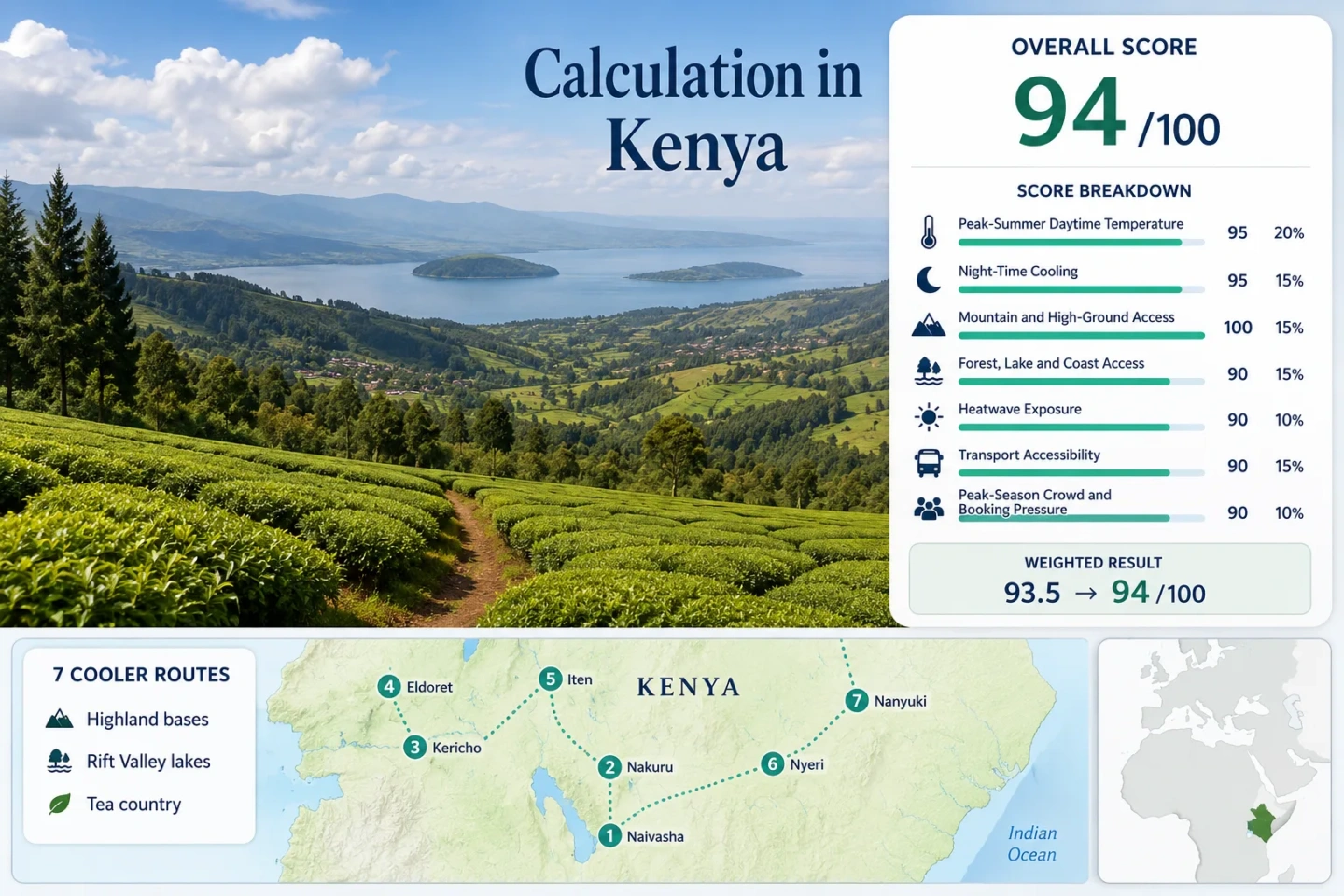
Kenya Highland Cooldowns: Rift Valley Lakes, Tea Country and Mountain Air
Kenya’s equatorial position does not prevent a genuinely cool highland journey. The strongest relief comes from elevation: Rift Valley lake towns sit near 1,850 metres, Kericho’s tea slopes rise to roughly 2,000 metres, and the Eldoret–Iten corridor reaches still higher ground. July and August bring the clearest cooldown pattern, with mild afternoons, cold-to-cool nights and route choices that shift between lakeside sun, wet tea-country cloud and mountain-edge air.
Two Rift Valley lake bases, two western highland towns, tea country and two Mount Kenya–Aberdare gateways.
Kenya’s coolest widespread daytime pattern, although rain remains frequent around Kericho, Eldoret and Iten.
Escarpment elevation strengthens night cooling and lowers afternoon heat compared with the Rift floor.
Convenient high-elevation lake towns, but exposed shoreline afternoons can feel warmer than forested or cloudier routes.
Stable low-20s daytime temperatures are paired with much wetter July–August conditions than Nyeri or the Mount Kenya east side.
The coolest western routes also carry more drizzle, cloud, afternoon showers and slower last-mile travel.
From the Rift Valley Lakes to the Mount Kenya Slopes
The route set moves north and west from Naivasha and Nakuru to Kericho, Eldoret and Iten, then returns east through Nyeri and Nanyuki. Numbered markers match the destination cards and the comparison matrix.
Markers show planning centres for the selected highland routes, not guaranteed legal parking, park gates, trailheads or exact viewpoints. Use the Google Maps links and current local access information before travelling.
Kenya Highland Cooler Escape Suitability Score
This transparent editorial suitability index uses disclosed climate, landscape, access and pressure factors for the seven routes shown on the map. It is not an official climate classification or a weather forecast.
Method: Median of each route’s July–August mean daily maximum, using direct Kenya Meteorological Department climatologies where available and geographically reasonable official city proxies elsewhere.
Raw: Route median 21.95°C. Linear normalization between 21°C = 100 and 23°C = 90 gives 95.25, displayed as 95/100.
Route values: Lake Naivasha 23.95°C; Lake Nakuru 23.95°C; Kericho 23.10°C; Eldoret 21.85°C; Iten 21.85°C; Nyeri 20.55°C; Nanyuki 21.95°C. Median: 21.95°C.
Source mapping: Lake Nakuru, Kericho, Eldoret and Nyeri — direct city climatologies; station codes are not published on the cited WMO city pages. Lake Naivasha — Nakuru representative station, roughly 70 km northwest at a broadly similar highland elevation. Iten — Eldoret representative station, roughly 30 km west and about 300 m lower, so the proxy is conservative for Iten. Nanyuki — Meru representative city climatology, roughly 65 km east and several hundred metres lower; Mount Kenya’s terrain limits direct comparability.
Period: Mixed official periods. Nyeri and Meru temperature tables state 1980–2018; other cited city pages publish the climatology without a clearly separated temperature-normal period.
Sources: Kenya Meteorological Department JJA 2026 outlook and 1991–2020 temperature climatology; WMO/KMD Nakuru climatology; WMO/KMD Kericho climatology; WMO/KMD Eldoret climatology; WMO/KMD Nyeri climatology; WMO/KMD Meru climatology.
Method: Median of route-level July–August mean daily minimum temperatures, using the same direct and representative official city mapping as the daytime factor.
Raw: Route median 9.95°C. The methodology’s 10–16°C comfort band scores 100; 9.95°C rounds to the band boundary without using an extreme-night value.
Route values: Lake Naivasha 9.95°C; Lake Nakuru 9.95°C; Kericho 11.15°C; Eldoret 9.70°C; Iten 9.70°C; Nyeri 12.00°C; Nanyuki 12.35°C. Median: 9.95°C.
Source mapping: Direct city climatologies for Nakuru, Kericho, Eldoret and Nyeri; Nakuru represents Naivasha, Eldoret represents Iten and Meru represents Nanyuki. The Iten proxy probably understates the amount of cooling because Iten is higher than Eldoret.
Period: Same mixed official climate periods used for the daytime calculation; July and August monthly minima were averaged for each mapped route.
Sources: Nakuru monthly minima; Kericho monthly minima; Eldoret monthly minima; Nyeri monthly minima; Meru monthly minima.
Method: Fixed elevation-access rubric. A lodging base at 900 m or higher scores 100 even before optional travel to higher park, escarpment or mountain terrain.
Raw: All seven route bases are substantially above 900 m; the route median is 100/100.
Route scores: Lake Naivasha 100 — base about 1,880 m; Lake Nakuru 100 — base about 1,850 m; Kericho 100 — base about 2,000 m; Eldoret 100 — base about 2,100 m; Iten 100 — base about 2,400 m; Nyeri 100 — base about 1,750 m; Nanyuki 100 — base about 1,940 m. Median: 100/100.
Route rationale: Naivasha and Nakuru are already high Rift Valley bases. Kericho and Eldoret occupy elevated agricultural plateaus. Iten sits above the Elgeyo Escarpment. Nyeri and Nanyuki provide highland accommodation before any ascent toward the Aberdares or Mount Kenya.
Period: Current geographic and access status reviewed July 2026; elevations are rounded planning values rather than survey benchmarks.
Sources: County Government of Kericho overview; Kenya Wildlife Service — Hell’s Gate; Kenya Wildlife Service — Lake Nakuru; Kenya Wildlife Service park directory.
Method: Fixed physical-access rubric measuring large forest, lake, river-system or coast access within 30 minutes. Scenic quality does not affect the score.
Raw: Route scores are 75 or 100; the seven-route median is 100/100.
Route scores: Lake Naivasha 75 — one major lake system within the route; Lake Nakuru 100 — lake plus protected woodland habitat; Kericho 100 — tea belt beside Mau forest and river catchments; Eldoret 75 — forest and river access without a major lake at the urban base; Iten 75 — escarpment forest and river-valley access; Nyeri 100 — Aberdare forest plus mountain rivers; Nanyuki 100 — Mount Kenya forest plus the upper Ewaso Ng’iro river network. Median: 100/100.
Route rationale: The lake routes provide immediate water access, while the central and western routes gain their score through montane forest, catchment and river systems. Coast access is not relevant to this inland portfolio.
Period: Current protected-area and geographic access reviewed July 2026; actual gate, trail and shoreline access can change after rain or conservation restrictions.
Sources: Lake Nakuru National Park; Hell’s Gate National Park; Kenya Wildlife Service protected areas; Kenya Forest Service.
Method: Conservative categorical proxy fallback. A common official daily 30°C-threshold series was not available for all seven routes, so no exact exceedance-day count is claimed. Route classes combine official KMD highland temperature climatology with the disclosed WMO/KMD July–August mean maxima.
Raw: Median route class 90/100. This factor is deliberately lower-confidence than the temperature-normal factors and is the main reason for the C comparability grade.
Route scores: Lake Naivasha 75 — warmer Rift-lake proxy with a mean maximum near 24°C; Lake Nakuru 75 — direct mean maximum near 24°C; Kericho 90 — direct mean maximum near 23.1°C; Eldoret 90 — direct mean maximum near 21.85°C but occasional warm spells remain possible; Iten 100 — high escarpment base represented conservatively by lower Eldoret; Nyeri 100 — direct mean maximum near 20.55°C; Nanyuki 100 — high plateau and Mount Kenya foothill base represented by Meru. Median: 90/100.
Source mapping: The Kenya Meteorological Department 1991–2020 JJA climatology identifies the highlands east and west of the Rift Valley as Kenya’s coolest broad zones. Route-level temperature context comes from the same direct and representative WMO/KMD city pages used above. These categories are screening values, not observed 30°C-day percentages.
Period: KMD 1991–2020 JJA regional climatology, mixed official route climatology periods and official 2025–2026 cold-season monitoring context.
Sources: Kenya Meteorological Department JJA 2026 outlook and 1991–2020 climatology; KMD August 2025 outlook and July temperature review; WMO/KMD Nakuru climatology; WMO/KMD Eldoret climatology; WMO/KMD Nyeri climatology.
Method: Fixed accessibility rubric based on intercity reach and the complexity of the last mile. A score of 80 indicates straightforward access from a major hub but some local transfer dependence.
Raw: Route median 80/100.
Route scores: Lake Naivasha 80 — frequent Nairobi road corridor, local vehicle useful for shoreline and park access; Lake Nakuru 80 — major intercity road hub, separate transfer for the national park; Kericho 60 — longer coach journey and vehicle-dependent tea-estate touring; Eldoret 80 — scheduled air and road links, simple urban arrival; Iten 60 — Eldoret connection followed by a road transfer; Nyeri 80 — direct road services, local transfer for mountain gates; Nanyuki 80 — direct road services and an airfield, but trailheads and conservancies require onward transport. Median: 80/100.
Route rationale: None of the seven routes is isolated, yet no single rail-based network links the full portfolio. Park gates, tea estates, lake shores and mountain approaches remain the decisive last-mile gap.
Period: Current transport structure reviewed July 2026; individual operators and departure times require fresh confirmation.
Sources: Kenya Airports Authority; Kenya National Highways Authority; Kenya Wildlife Service access information.
Method: Official-capacity categorical fallback. Comparable route-level July–August accommodation occupancy was unavailable, so park entry, lodge concentration, event demand and weekend pressure were assessed with the fixed rubric.
Raw: Route median 60/100, indicating regular pressure at focal points rather than portfolio-wide capacity failure.
Route scores: Lake Naivasha 40 — concentrated weekend resort and Hell’s Gate demand; Lake Nakuru 40 — national-park and city demand converge; Kericho 80 — dispersed town capacity with limited widespread booking pressure; Eldoret 80 — substantial urban accommodation base; Iten 60 — training-camp demand concentrates in a small highland town; Nyeri 60 — park-edge lodging and gate planning matter on busy dates; Nanyuki 40 — Mount Kenya, conservancy and lodge demand overlap. Median: 60/100.
Route rationale: Pressure is highly local. A room in Eldoret or Kericho can remain easier to secure while a specific park lodge, running camp, conservancy stay or Naivasha weekend property fills much earlier.
Period: Most recent public capacity and tourism context available through July 2026; this factor uses a categorical fallback rather than a common occupancy series.
Sources: Kenya Wildlife Service park access and capacity context; Kenya Tourism Board destination information; Kenya National Bureau of Statistics tourism publications.
Weighted total: 95×0.25 + 100×0.20 + 100×0.15 + 100×0.15 + 90×0.10 + 80×0.10 + 60×0.05 = 93.8 → 94/100
Lakeside Bases, Tea Slopes and High-Elevation Towns
The seven bases are not interchangeable. Naivasha and Nakuru emphasise lake access, Kericho prioritises cloudier tea-country air, Eldoret and Iten extend the western highland line, and Nyeri–Nanyuki divide the Aberdare and Mount Kenya approaches.
Lake Naivasha: High Water, Open Sun and Easy Rift Access
Naivasha is the most convenient lake cooldown from Nairobi, but elevation does more work than the water itself. The Nakuru representative climatology gives a July–August mean maximum near 24.0°C and mean minimum near 10.0°C. Lakeside lawns can feel bright and exposed at midday, while evenings cool quickly.
Route logic: Use the town or south-lake accommodation as a base, then separate Hell’s Gate, Mount Longonot and shoreline activities into their own days. The lake edge, park gates and viewpoints are not one walkable cluster.
Lake Nakuru: A Cooler City Base Beside a Protected Lake
Nakuru combines a substantial city base with immediate access to Lake Nakuru National Park. Official monthly values average roughly 23.95°C by day and 9.95°C at night across July and August. The lake-and-woodland setting adds shade and wildlife access without requiring a remote lodge.
The trade-off is logistical rather than climatic: urban arrival is straightforward, but park entry, opening times and vehicle arrangements remain separate from the city-centre stay.
Kericho Tea Country: Mild Afternoons with a Wetter Sky
Kericho is the route where temperature stability and rainfall are inseparable. Official July–August means sit near 23.1°C by day and 11.15°C at night, while monthly rainfall rises from about 154.7 mm in July to 183.0 mm in August. Tea slopes stay intensely green because the cooldown is frequently delivered with cloud, mist and showers.
Why it stands out: The town works for slow drives, estate-edge scenery and cooler mornings, not for a guaranteed sequence of clear mountain panoramas. Waterproof footwear and flexible timing matter more here than on the drier Nyeri side.
Open Kericho Tea Country in Google MapsEldoret Highlands: Urban Services on a Cool Western Plateau
Eldoret provides the most practical full-service base in the western highland group. The published climatology averages about 21.85°C for July–August daytime maxima and 9.7°C for minima, with 16–17 precipitation days per month. The air is cool, but the weather rhythm is often damp and changeable.
Accommodation choice is broad compared with Iten, and transport links are easier. The city is therefore useful when the priority is reliable services, a cooler sleep and day trips rather than an isolated landscape stay.
Iten and Elgeyo Escarpment: Thin Air Above the Rift Drop
Iten is the highest overnight base in the set. Eldoret’s official values are used conservatively because the direct comparable station is not available in the cited city series; Iten is roughly 300 metres higher and commonly cooler. The elevation, running culture and abrupt escarpment edge create a markedly different atmosphere from the Rift lakes below.
Road transfer from Eldoret is simple, yet accommodation capacity is smaller and tied partly to training camps. Valley views can disappear quickly under cloud, and exposed edges require caution in rain or low visibility.
Nyeri and the Aberdare Foothills: Dry-Season Cool with Two Mountain Fronts
Nyeri records the lowest direct July–August daytime mean in the selected official city series: about 20.55°C, with nights near 12°C. Published rainfall is roughly 29.9 mm in July and 33.9 mm in August, far below Kericho’s totals. This makes Nyeri a cooler base without the same level of persistent tea-belt wetness.
The town sits between the Aberdares and Mount Kenya, but access should not be treated as a single mountain circuit. Park gates, forest roads and higher terrain require separate routing, current gate information and realistic driving time.
Open Nyeri and the Aberdare foothills in Google MapsNanyuki and Mount Kenya Foothills: Cool Nights with a Drier Eastern Lean
Nanyuki combines highland town services with access toward Mount Kenya and the Laikipia plateau. The Meru representative climatology gives a July–August mean maximum near 21.95°C and minimum near 12.35°C. The proxy is lower and east of Nanyuki, so local cloud, wind and mountain-slope effects can differ sharply within short distances.
The town is easier to reach than the higher trailheads. A stay can remain car-light in the centre, but mountain gates, conservancies and remote lodges require planned transfers. Clear mornings are more dependable than clear afternoons near the massif.
Seven Highland Bases Compared by Heat, Access and Weather Trade-Offs
Temperature values use the same direct or representative station mapping disclosed in the score. Elevations are rounded town-base values; mountain and park temperatures can be substantially lower.
| Route | July–August Mean Max / Min | Approx. Base Elevation | Arrival Pattern | Weather Trade-Off | Pressure Pattern |
|---|---|---|---|---|---|
| Lake Naivasha | 23.95°C / 9.95°C · Nakuru proxy | 1,880 m | Direct Nairobi road corridor; local transfer for shore and parks | Bright lake-edge afternoons; fast evening cooling | Weekend resort and Hell’s Gate demand |
| Lake Nakuru | 23.95°C / 9.95°C · direct | 1,850 m | Major intercity road hub; separate park entry | More wet days than Nyeri; urban and park conditions differ | City and national-park demand overlap |
| Kericho | 23.10°C / 11.15°C · direct | 2,000 m | Longer road journey; estate touring favours a vehicle | Very wet July–August tea-belt climate | Lower widespread pressure; scattered estate access |
| Eldoret | 21.85°C / 9.70°C · direct | 2,100 m | Scheduled air and intercity road access | Frequent rain days despite low daytime heat | Broad urban room supply |
| Iten | 21.85°C / 9.70°C · Eldoret proxy | 2,400 m | Road transfer from Eldoret | Colder base, cloud-prone escarpment views | Small-town and training-camp concentration |
| Nyeri | 20.55°C / 12.00°C · direct | 1,750 m | Direct road services; vehicle for park gates | Drier than western routes; mountain cloud still local | Gate and park-edge lodging pressure on busy dates |
| Nanyuki | 21.95°C / 12.35°C · Meru proxy | 1,940 m | Road and airfield access; transfers for mountain approaches | Town conditions do not represent high mountain terrain | Conservancy, lodge and mountain demand converge |
Why the Rift Valley Lake Bases Are Not the Coldest Options
Naivasha’s Water Does Not Cancel Midday Sun
The lake softens the landscape and supports cool evenings, yet open shoreline properties receive strong equatorial sun. A 24°C mean maximum can feel warmer in exposed gardens than a similar reading under Kericho cloud or Aberdare forest.
Nakuru Splits the Stay Between City and Park
The city is a practical base, while the lake’s protected woodland and wildlife zone sit behind a separate gate-and-vehicle decision. Shade and lake influence are strongest inside the park rather than uniformly across the urban area.
Iten Gains Elevation Instead of Water Moderation
Iten’s advantage comes from altitude and exposure above the escarpment. It lacks the easy water-based leisure of Naivasha, but it delivers a stronger night-cooling signal and lower heat risk for walking or running.
Kericho’s Tea Belt Trades Dry Skies for Stable Temperatures
Kericho’s July–August rainfall totals are several times those published for Nyeri, even though daytime temperatures remain similarly restrained. That contrast changes the correct packing and daily rhythm. Kericho rewards early departures, short flexible drives and indoor alternatives when cloud thickens; Nyeri more often supports a longer outdoor block before afternoon mountain weather develops.
Tea Roads and Visibility
Minor roads between estates can become slower in rain and mist. A nominally short scenic loop should not be timed like a dry paved urban transfer.
Footwear Matters More Than Heavy Insulation
Temperatures are mild rather than severe. A waterproof outer layer, dry footwear and a change of socks solve more problems than bulky cold-weather clothing.
Cloud Can Improve Midday Comfort
Persistent cloud reduces radiant heat across exposed tea slopes. The same cloud can erase long views, so visual expectations and thermal comfort do not always move together.
Mount Kenya and Aberdare Days Depend on Gate, Cloud and Altitude
Nyeri and Nanyuki are cool towns, not substitutes for high-mountain forecasts. Elevation rises rapidly beyond both bases, and cloud, wind and rain can intensify along forested slopes. A clear breakfast in town does not guarantee an open view or dry trail higher up.
Nyeri Sits Between Two Mountain Systems
Aberdare gates and Mount Kenya approaches point in different directions. Combining them casually in one day creates excessive driving and weakens the cooling benefit with long vehicle hours.
Nanyuki’s Last Mile Is the Real Access Question
Arrival in town is straightforward. Reaching a conservancy, park gate, lodge or trailhead is a separate transfer with its own road condition, entry time and weather exposure.
Car-Light Towns Still Have Last-Mile Gaps
Eldoret, Nakuru, Nyeri and Nanyuki work as service-rich towns without a private vehicle for meals and basic errands. The cooling landscapes named in the title are less car-light: lake shores, park gates, tea estates, escarpment viewpoints and mountain approaches sit beyond ordinary town movement.
Simpler Arrivals
Nakuru, Eldoret, Nyeri and Nanyuki have the clearest intercity arrival pattern and a broad choice of town accommodation.
One Planned Transfer
Iten works well with an Eldoret connection; the important decision is fixing the final road transfer rather than hiring a vehicle for the full trip.
Vehicle-Dependent Days
Lake Nakuru, Hell’s Gate, Aberdare gates and Mount Kenya approaches require specific transport arrangements even when the overnight base is easy to reach.
Rain-Time Buffer
Kericho, Eldoret and Iten need more schedule slack because wet minor roads and low visibility can stretch short-looking distances.