Rwanda for Mild Highland Travel: Volcano Lakes, Forest Roads and Hill-Country Air
Rwanda’s western and northern routes remain mild because most overnight bases sit well above the East African lowlands. The clearest cool-air pattern runs from the Virunga foothills and the Burera–Ruhondo lake basin to the elevated forests above Lake Kivu and the long ridge road through Nyungwe. July and August bring the most dependable dry-season access, although exposed lakeside towns can warm noticeably after midday.
Volcano foothills, twin lakes, montane forests, Lake Kivu towns and two southern hill-country bases form the scoring set.
Rwanda’s long dry season generally improves road reliability, trail access and visibility across the western highlands.
High forest elevation, shaded roads and cool nights create the strongest sustained relief from exposed afternoon heat.
Even the Lake Kivu bases remain elevated, while Musanze, Huye and the forest ridges sit substantially higher.
Nyungwe, Gishwati and the Virunga foothills retain cooler days; Karongi and Rubavu gain more from evening lake air.
Volcanoes and Nyungwe activities need earlier planning, while Twin Lakes and forest-sector roads work more smoothly with a vehicle.
Virunga Lakes, Kivu Hills and the Nyungwe Ridge
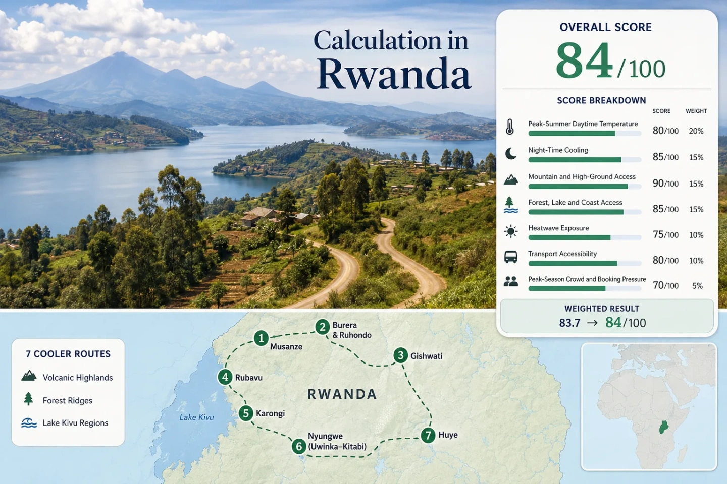
The marker sequence follows Rwanda’s cooler western arc from the volcanic northwest to the southern highlands. It separates towns that work as practical overnight bases from lake viewpoints and protected forest sectors that require additional local transport.
Markers show selected highland regions and practical planning centres, not guaranteed legal parking areas, trailheads or exact viewpoints. Protected forests, volcano treks and lake departures may use separate meeting points. Check the access notes and Google Maps link in each route card before travelling.
Rwanda Highland Cooler Escape Suitability Score
This transparent editorial suitability index uses disclosed climate, landscape, access and seasonal-pressure factors for the seven routes shown on the map. It is not an official climate classification or a weather forecast.
Weighted total: 100×0.25 + 100×0.20 + 100×0.15 + 75×0.15 + 100×0.10 + 80×0.10 + 60×0.05 = 92.3 → 92/100
Method: Route count creates no bonus. Each route carries equal weight, route-level values are combined using the median and the seven fixed factor weights total 100%. Climate proxy limitations are reflected in the C comparability grade.
Volcano Foothills, Lake-Kivu Towns and Forest Ridges
The route sequence favours overnight bases where elevation moderates both the afternoon and the sleeping temperature. Musanze, Rubavu, Karongi and Huye provide the easiest services; the Twin Lakes, Gishwati and Nyungwe add stronger landscape cooling but require more deliberate local transport.
Musanze and the Volcanoes Foothills
Musanze sits near 1,850 m below the Virunga Massif, making it Rwanda’s most practical high-elevation town base. The July–August route profile is close to a 21.1°C mean daily maximum and 11.8°C mean minimum, while the protected volcanic terrain rises rapidly toward peaks including Karisimbi at 4,507 m.
Restaurants, banks and accommodation are concentrated in town, but gorilla tracking, crater hikes and other park activities begin from assigned meeting points. A local driver is useful even when the Kigali–Musanze leg is completed by bus.
Lakes Burera and Ruhondo
Burera and Ruhondo occupy a high volcanic basin north and east of Musanze. Lake Ruhondo lies near 1,760 m and Burera near 1,860 m, so the water surface is already higher than many East African hill towns. A representative peak-dry-season profile of roughly 20.8°C by day and 11.6°C at night keeps dawn boat departures and ridge viewpoints notably cool.
The lake pair is reached by winding secondary roads, with many viewpoints located above the shore rather than beside a continuous waterfront. The official tourism material notes that a Twin Lakes viewpoint can be reached by car and that boat trips can be arranged.
Gishwati–Mukura Highlands
The coolest daytime profile in the route set belongs to the high forest divide. Route-centre estimates are about 19.6°C for the July–August mean maximum and 10.8°C for the mean minimum, reflecting forest sectors that commonly sit above 2,000 m.
Gishwati and Mukura are separate forest blocks in the mountains above Lake Kivu. This is not a simple lakeside stop: access involves high roads, arranged activities and careful confirmation of the active visitor sector. The reward is a shaded landscape with less direct solar exposure than Rubavu or Karongi.
Rubavu and Northern Lake Kivu
Rubavu provides the easiest combination of a full-service town, direct lake access and onward movement toward Musanze or the Congo Nile Trail. The lakeside base is near 1,460 m, with an approximate July–August profile of 23.4°C maximum and 16.2°C minimum.
Daytime conditions are warmer than the Virunga foothills, but evenings benefit from open water and the elevated basin. The town marks the northern end of the 227 km Congo Nile Trail, allowing a mild-waterfront stay to be combined with higher cycling or walking stages.
Karongi and the Central Kivu Hills
Karongi is a calm central-lake base backed by pine, eucalyptus and steep cultivated hills. Its overnight elevation is close to 1,450 m, yet the July–August mean maximum is around 25.0°C, making it the warmest afternoon option in this highland set. Nights remain much milder at about 16.0°C.
The most comfortable rhythm places exposed walks and boat departures early, then uses shaded hills or waterfront accommodation during the strongest afternoon sun. Karongi works particularly well when cooler sleep and lake access matter more than maintaining sub-22°C daytime conditions.
Uwinka–Kitabi and the Nyungwe Forest Road
The road through Nyungwe crosses a high, densely wooded ridge where the air can change within a short drive. Representative July–August values are approximately 20.4°C for the mean maximum and 11.3°C for the mean minimum, with common visitor zones above 2,000 m.
Uwinka is the operational centre for several forest activities, while Kitabi and the tea-country approaches offer practical overnight alternatives. The canopy experience operates throughout the year, but official advice still recommends suitable footwear and a lightweight raincoat because afternoon rain remains possible during the dry season.
Huye Hill-Country Base
Huye is a compact southern highland city near 1,750 m and a useful break between Kigali and Nyungwe. Its representative July–August profile is about 24.1°C by day and 13.0°C at night, preserving a strong overnight-cooling advantage without the logistical constraints of sleeping inside a forest park corridor.
Huye suits travellers who prefer museums, restaurants and ordinary town services before continuing west. It does not provide the same immediate lake or rainforest effect as the other routes, but it reduces the long Kigali–Nyungwe transfer into more manageable stages.
Why the Virunga–Kivu Elevation Step Changes the Air
Rwanda’s western route is not one uniform highland. It descends in stages from forest and volcanic terrain above 2,000 m to Lake Kivu bases around 1,450–1,460 m. That vertical change is large enough to alter the useful time of day, even when two stops are separated by only a few hours of driving.
Virunga Foothills
Musanze and the Twin Lakes retain the clearest cool-morning pattern. Early departures commonly begin near the 11–12°C overnight range, and cloud can hold against the volcano slopes after nearby areas have brightened.
Congo–Nile Forest Divide
Gishwati and Nyungwe gain from both elevation and canopy. The road may stay cool through the afternoon, but forest moisture, mist and short showers can reduce visibility without producing lowland-style heat.
Lake Kivu Shore Band
Rubavu and Karongi are warmer under direct sun. Their advantage arrives later: elevated-lake air, open-water exposure and night minima near 16°C prevent the persistent evening warmth found in many tropical lake basins.
Rubavu–Karongi Works as a Ridge-and-Lake Journey
The Congo Nile Trail extends 227 km from Rubavu toward Rusizi, with official material dividing the corridor into walkable and rideable stages. It does not remain on a flat shoreline. The route repeatedly climbs through villages, coffee areas, eucalyptus-lined roads and lake-facing hills before descending toward the next settlement.
Northern Stages from Rubavu
The early sections combine accessible town services with short trail stages such as Rubavu–Cyimbiri and Cyimbiri–Kinunu. This portion is easier to integrate into a short trip, but midday sun is more exposed than in the montane forest routes.
Useful rhythm: Begin walking or cycling early, pause around the strongest afternoon sun and use the lakefront for evening recovery.
Central Hills around Karongi
Karongi sits among steeper lake-facing hills and functions as both an endpoint and a restart point for selected stages. Boat links may shorten individual sections, while road transfers provide a fallback when steep gradients or weather make a full trail day impractical.
Main caution: Horizontal distance understates the effort because repeated climbs create more exposure than the map line suggests.
Nyungwe’s Forest Road Keeps Its Own Weather
The Huye–Kitabi–Uwinka corridor enters one of Africa’s older montane rainforest systems. Forest cover suppresses direct solar heating, while the ridge repeatedly crosses cloud, mist and shaded valleys. Conditions can therefore feel cooler than the temperature alone suggests, especially during stops beneath the canopy.
Uwinka Departures
Activity briefings use defined times and meeting locations. Staying far from the visitor centre can turn a cool forest morning into a very early road transfer, so accommodation location matters as much as room price.
Dry Season Does Not Mean Dry Forest
July and August reduce the broader seasonal rainfall burden, but short showers remain possible. Lightweight rain protection and footwear with traction are still relevant for canopy and trail activities.
Ridge Driving and Light
Curves, wildlife awareness and rapidly changing visibility favour completing long forest-road transfers in daylight. The same road that feels calm and cool at noon can become slow after cloud settles into the trees.
Which Highland Base Fits the Travel Pattern?
All seven scored routes are included so the comparison remains aligned with the map and suitability calculation. The temperature values are route-centre or representative climatology figures rather than day-specific forecasts.
| Route | July–August Day / Night | Main Cooling Mechanism | Access Pattern | Primary Trade-Off |
|---|---|---|---|---|
| Musanze and Volcanoes Foothills | 21.1°C / 11.8°C | High town base and volcanic slopes | Direct town transport; local vehicle for park sectors | Permit and accommodation pressure |
| Lakes Burera and Ruhondo | 20.8°C / 11.6°C | High lake basin and volcano-side air | Secondary roads from Musanze | Vehicle dependence and steep turns |
| Gishwati–Mukura Highlands | 19.6°C / 10.8°C | Montane forest above the Congo–Nile Divide | Arranged or vehicle-dependent forest access | Limited visitor infrastructure |
| Rubavu and Northern Lake Kivu | 23.4°C / 16.2°C | Elevated lake air and open shoreline | Direct intercity base | Warmer exposed afternoons |
| Karongi and Central Lake Kivu | 25.0°C / 16.0°C | Lake-night cooling and surrounding hills | Direct town access; boat and trail options | Warmest daytime profile in the set |
| Uwinka–Kitabi and Nyungwe | 20.4°C / 11.3°C | High ridge, dense canopy and forest moisture | Long road transfer; vehicle required for sectors | Rain, mist and fixed activity times |
| Huye Hill-Country Base | 24.1°C / 13.0°C | High urban plateau and strong night cooling | Direct intercity services | No immediate major lake or rainforest |
Dry-Season Timing across the Seven Routes
June to Early July
Lowest-heat advantage: Nights are cool across the northern and forest routes, while vegetation remains greener after the long rains. Some tracks can still retain mud, and cloud may linger around the Virungas and Nyungwe.
Late July to August
Road-access advantage: This is the most dependable period for combining the Twin Lakes, Kivu road and Nyungwe. Karongi and exposed lakeside roads become warmer in the afternoon, while the forest ridges remain mild.
September Transition
Fewer-crowds trade-off: The first returning showers can refresh the landscape and reduce dust, but they also make trail and road timing less predictable. Forest activities still require rain preparation.
Practical route order: Musanze and the Twin Lakes work well before Rubavu, followed by Karongi, Huye and Nyungwe. Gishwati can be inserted between the northern Kivu and central-lake stages when guided access and road conditions are confirmed.