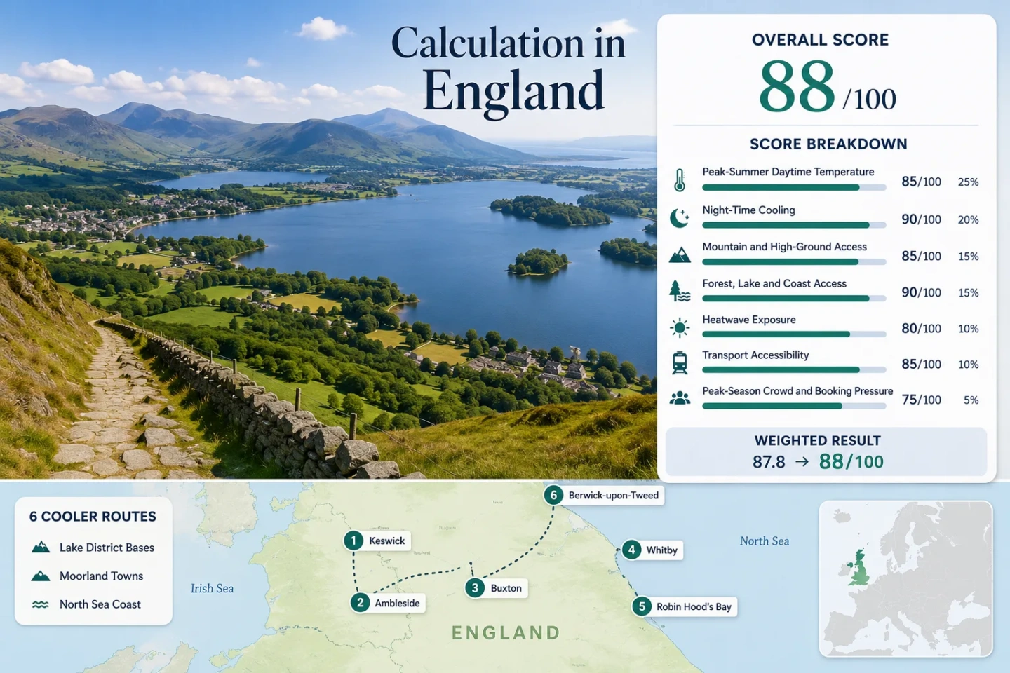
England for Mild Summer Routes: Northern Lakes, Moorland Towns and Breezy Coasts
England’s milder summer routes are concentrated around the Lake District’s water-and-fell system, elevated Pennine towns and North Sea settlements exposed to maritime air. July and August daytime normals across the selected bases remain close to 19–20°C, while typical overnight temperatures near 11–12°C provide meaningful night-time relief. Rain, coastal mist, busy school-holiday roads and rapid weather changes remain the principal trade-offs.
Two Lakeland bases, one elevated spa town and three North Sea settlements form the shared map, score and comparison set.
Median July–August average maximum from the disclosed 1991–2020 Met Office records.
The selected routes generally retain cool nights even when inland southern England experiences hotter conditions.
Each base has regular rail or bus access, although Keswick and Ambleside require a transfer from a railhead.
Lakes, the North Sea or the River Tweed provide a direct water-edge component on all routes except Buxton.
Cooler air does not mean settled weather; Lakeland rainfall and coastal holiday demand can alter daily plans.
From Lakeland Basins to the North Sea Edge
The route set links two Lake District bases, Buxton’s elevated moorland position and three exposed coastal settlements. The numbered markers match the destination cards and score evidence.
This marker map is built for planning orientation. Marker positions use approximate public settlement centres rather than guaranteed legal parking areas, trailheads or exact viewpoints. Use the named Google Maps links and current local access information before travelling.
England Northern Lakes, Moorland and Coast Suitability Score
This transparent editorial suitability index uses disclosed climate, landscape, access and pressure factors for the six selected routes. It is not an official climate classification, a guarantee of cool weather or a live forecast.
Weighted total: 100×0.25 + 100×0.20 + 45×0.15 + 100×0.15 + 95×0.10 + 100×0.10 + 40×0.05 = 88.3 → 88/100
Method: Route count does not add bonus points. Each route has equal weight, route-level values are combined using the median, and the seven fixed factor weights are then applied.
Data limitation: The heatwave factor is a conservative proxy rather than a completed common-period daily threshold count. The score should be recalculated if route-level daily 30°C exceedance data are extracted from the identified official dataset.
Lakeland Bases, Pennine Heights and North Sea Towns
The route set separates three distinct cooling mechanisms: lake-and-fell terrain, an elevated moorland accommodation base and exposed coastal air. The temperature figures are historical July–August averages, not forecasts for a particular trip.
Keswick and Derwentwater
Lake-and-fell cooling defines Keswick more clearly than elevation at the town centre. The July–August Met Office normal averages about 19.48°C by day and 11.48°C at night, while Derwentwater and wooded lower slopes create immediate alternatives to exposed streets.
Keswick has no railway station, but regular buses connect it with Penrith. Car-free travel is practical when accommodation and daily walks are planned around the town, lake launches and established bus corridors.
Ambleside and the Windermere Head
Ambleside combines Windermere access, wooded valleys and short links toward higher passes. Its July–August average is about 20.09°C for daytime maxima and 11.75°C for night-time minima. The figures are slightly warmer than Keswick’s, but overnight relief remains strong.
Access pattern: Trains terminate at Windermere, followed by a regular bus connection to Ambleside. Local buses and lake services can support a low-car stay, although late-evening flexibility is more limited than daytime coverage.
The practical trade-off is rainfall rather than heat alone: Ambleside’s disclosed climate normal is wetter than the east-coast routes, so waterproof layers and indoor alternatives carry real planning value.
Buxton on the High Peak
Buxton is the clearest elevated town-base in the route set. The town sits around the 300 m elevation band and records the lowest disclosed July–August averages: approximately 18.89°C by day and 11.00°C at night.
Direct rail access from Greater Manchester reduces car dependence. Moorland weather can still change sharply, and open plateaus provide less shelter than Lakeland woodland during wind-driven rain.
Whitby and the Esk Estuary
The Whitby station series gives a July–August average maximum of about 19.83°C and minimum of 12.22°C for 1991–2020. Nights are milder than Buxton’s, but sea breezes can suppress afternoon heat when inland Yorkshire is warmer.
Rail services from Middlesbrough and coastal buses from Scarborough provide alternatives to driving. The railway is useful but comparatively slow, so arrival time should be treated as part of the route rather than a brief final transfer.
School-holiday pressure affects accommodation, harbour streets and parking. A central stay reduces repeated movement through the most constrained road approaches.
Robin Hood’s Bay Below the Moorland Edge
Robin Hood’s Bay descends sharply from the upper village to the sea, creating a route where parking, accommodation position and walking gradient matter as much as temperature. Whitby, roughly 8 km northwest, is used as the representative official station.
The North Sea and nearby moorland woodland support a strong water-and-forest access score. Accommodation in the lower village creates a steep return to upper transport stops, while upper-village stays simplify bus access but reduce immediate shoreline convenience.
Berwick-upon-Tweed at the Northern Coast
Berwick combines immediate East Coast Main Line access with the River Tweed and exposed Northumberland shoreline. The disclosed July–August average is approximately 20.16°C by day and 11.10°C at night.
Transport advantage: The station is inside the town, avoiding the rail-to-bus transfer required for Keswick and Ambleside. Coastal walks and town services can therefore be combined without a private car.
Wind can make the shoreline feel distinctly cooler than the town centre. That advantage becomes a drawback on unsettled days, when exposure rather than temperature determines walking comfort.
Which Cooling Mechanism Matches the Trip?
All six scored routes appear in the same decision table. The temperature column uses the disclosed July–August historical normals, while access and pressure describe practical route differences rather than climate measurements.
| Route | Day / Night Normal | Car-Light Pattern | Primary Cooling Mechanism | Main Summer Constraint |
|---|---|---|---|---|
| Keswick | 19.48°C / 11.48°C | Bus transfer from Penrith | Lake, woodland and fell-valley air | Road, parking and accommodation pressure |
| Ambleside | 20.09°C / 11.75°C | Train to Windermere, then bus | Large lake, wooded valleys and pass access | High rainfall and central Lakes demand |
| Buxton | 18.89°C / 11.00°C | Direct rail | Elevated accommodation base | Open moorland wind and rapid weather change |
| Whitby | 19.83°C / 12.22°C | Rail or interurban bus | North Sea breeze and estuary exposure | Coastal mist, parking and holiday crowds |
| Robin Hood’s Bay | 19.83°C / 12.22°C | Regular coastal bus | Sea air plus nearby moorland woodland | Steep village access and limited parking |
| Berwick-upon-Tweed | 20.16°C / 11.10°C | Direct intercity rail | Coast, river and northern latitude | Exposed wind and fewer sheltered alternatives |
Why Buxton’s Height Differs from Lakeland Cooling
Cooling Begins at the Buxton Base
Buxton’s town centre occupies roughly the 300 m elevation band, so its cooler signal is present around accommodation, shops and the railway station. The disclosed daytime normal of 18.89°C is the lowest in the route set.
This pattern suits travellers who want less dependence on daily excursion logistics. Moorland walks can begin from or near the town, though open terrain supplies less shade during clear spells and less shelter during wind-driven rain.
Lakeland Relief Depends on Water and Fells
Keswick and Ambleside sit much lower than the surrounding summits. Their summer value comes from cool nights, lake edges, wooded valleys and the ability to move toward higher passes rather than from a high accommodation altitude.
That structure creates more daily choices but also more movement. Bus queues, narrow roads and weather-dependent boat services can influence whether the theoretical range of cooler environments is practical on a busy day.
Whitby Mist and Berwick Wind Signal Different Coastal Days
A single “breezy coast” label hides important differences along England’s northern North Sea edge.
Whitby’s Mist Boundary
Cool marine air can create low cloud or fog around Whitby while inland valleys and moorland roads remain clearer. A grey harbour morning is therefore not reliable evidence of identical conditions across the North York Moors.
Robin Hood’s Bay Gradient
The steep descent toward the shore changes wind exposure over a short distance. Lower lanes may feel sheltered while the cliff edge and upper village receive stronger onshore air. The gradient also turns a short return journey into a meaningful climb.
Berwick’s Open Exposure
Berwick’s river mouth, walls and open coastline provide broader wind exposure than Whitby’s enclosed harbour streets. The cooling effect can remain noticeable in sunshine, but sheltered clothing becomes more useful when fronts cross the Northumberland coast.
Penrith, Windermere and the Cost of a Lakeland Transfer
Keswick and Ambleside both support car-light stays, but neither offers the same station-to-accommodation simplicity as Buxton, Whitby or Berwick. Keswick relies on the Penrith connection; Ambleside relies primarily on Windermere station and an onward bus.
Keswick Through Penrith
The Penrith transfer works well when arrival and departure sit inside the regular daytime bus window. Missed connections matter more in the evening, and heavy road traffic can make a nominally simple final leg less predictable during peak weekends.
Ambleside Through Windermere
Windermere provides a closer railhead and a well-used bus corridor, but Ambleside’s position can still create queues through the central Lakes. Accommodation near a principal stop reduces repeated climbs and short taxi dependence.
Direct-rail alternative: Buxton offers the clearest elevated town arrival, while Berwick provides the simplest coast-and-river arrival for travellers carrying luggage or avoiding road transfers.
When Lake Roads, Moorland Walks and Coastal Services Align
The useful window changes according to the intended activity. The lowest crowd pressure, warmest water and most reliable visitor transport do not occur at exactly the same time.
Late June
Useful for: Long daylight, open walking routes and generally lower accommodation pressure than the central school-holiday period.
Sea and lake water remain cool, and exposed coasts can feel chilly in onshore wind. Lakeland buses usually provide a workable network, but seasonal services should still be checked.
Mid-July to August
Useful for: The widest visitor-service window and the least restrictive combination of walking, boat and bus options.
This is also the main pressure period for Keswick, Ambleside, Whitby and Robin Hood’s Bay. Booking and parking constraints can outweigh small climatic differences between the routes.
Early September
Useful for: Reduced family-holiday pressure while historical temperatures often remain suitable for walking and town-based trips.
Daylight contracts, some seasonal services reduce frequency and Atlantic systems can become more influential. Buxton and direct-rail coastal bases retain simpler logistics when optional visitor services begin to thin.
Before departure: Check the Met Office forecast, rail or bus disruption, national-park access notices and local parking information. A route selected for historically mild averages can still experience short hot spells, heavy rain, low cloud or disruptive wind.