Wales for Cooler Summer Travel: Mountain Roads, Wild Coasts and Green Valleys
Wales combines Atlantic-facing headlands, reservoir valleys and mountain roads where July and August climate normals are often milder than those of lowland cities farther east. The main trade-off is not usually heat but rapid weather changes, frequent rain and peak-season pressure around Yr Wyddfa and the Pembrokeshire coast.
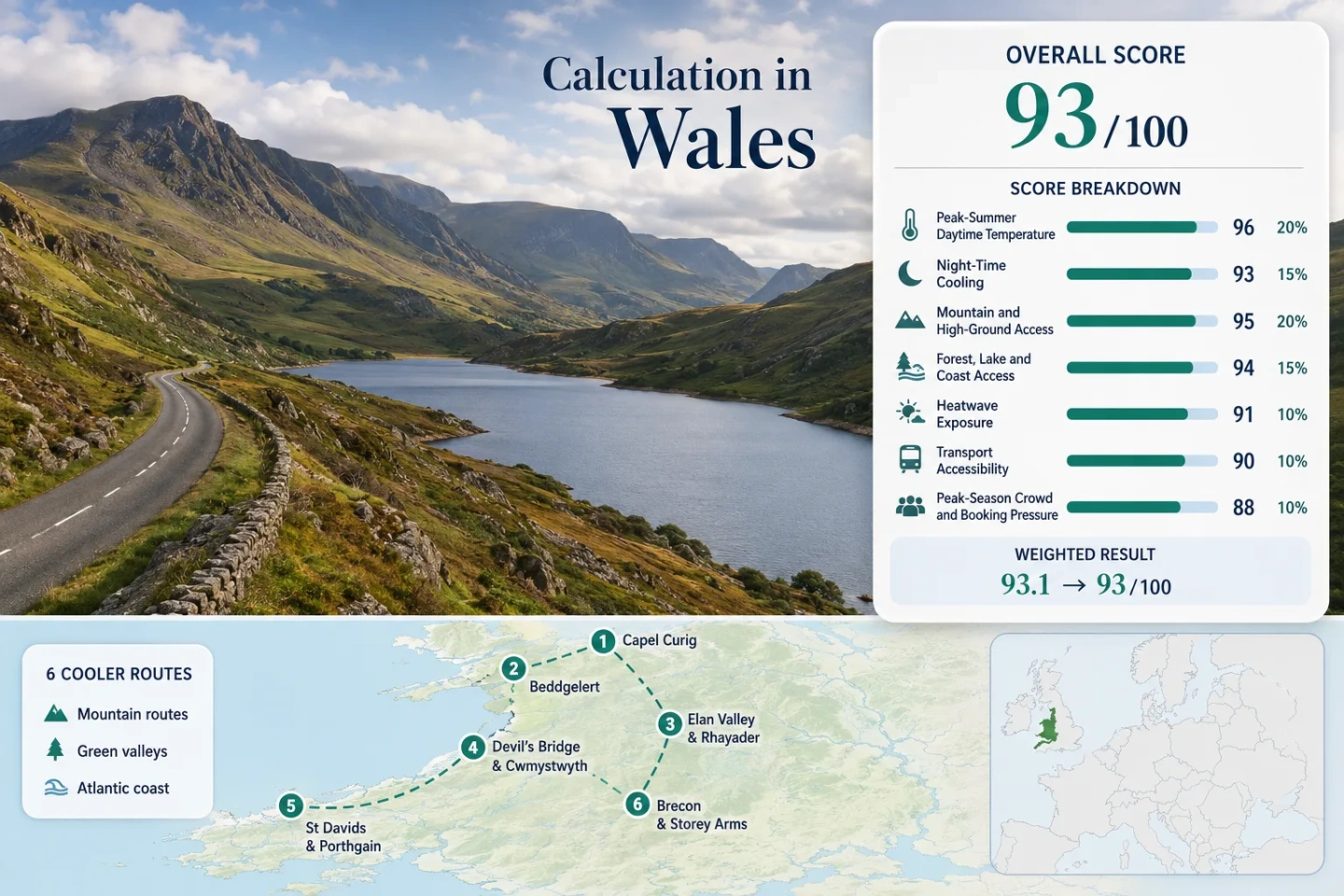
Two mountain corridors, two mid-Wales valleys, one Atlantic coast base and one southern upland route.
The July–August mean daily maximum at the official station is approximately 18.0°C.
Sherpa’r Wyddfa and TrawsCymru services connect several mountain bases and trail-access points.
Seasonal Pembrokeshire buses connect St Davids with Porthgain, Abereiddy, Strumble Head and other coast-path areas.
Exposed coasts moderate daytime heat while upland valleys retain cooler nights and rapid access to higher ground.
Mountain routes can receive rain on roughly half the days in the target period, while major parking areas fill early.
Mountain Roads, Reservoir Valleys and Atlantic Headlands
The selected points follow a north-to-south route set rather than treating the whole country as one climate zone.
Markers show selected cooler-route planning centres, not guaranteed legal parking, exact viewpoints or trailheads. Use the access notes and Google Maps links in each route card before travelling.
Wales Mountain and Coastal Cooler Escape Suitability Score
This transparent editorial index uses disclosed climate, landscape, access and pressure factors for the six displayed routes. It is not an official climate classification or a weather forecast.
Weighted total: 100×0.25 + 100×0.20 + 90×0.15 + 100×0.15 + 90×0.10 + 80×0.10 + 50×0.05 = 93.0 → 93/100
Method: Route count does not add bonus points. Route-level values are combined using the median before the seven fixed weights are applied.
High Passes, Reservoir Roads and Atlantic Coast Bases
The route set separates genuinely elevated bases from coastal places where wind and maritime air matter more than altitude.
Capel Curig and Ogwen Valley
July–August station normals average approximately 18.0°C by day and 11.3°C at night. Capel Curig sits within the mountain road network between Betws-y-Coed, Pen-y-Gwryd and the Ogwen Valley, allowing rapid movement toward higher or windier terrain.
The nearby official station records roughly 158 mm of rain in July and 190 mm in August. A rain shell and a lower-level alternative are more useful than relying on a fixed summit plan.
Beddgelert and Nant Gwynant
Beddgelert provides a lower village base near wooded river corridors, while the A498 climbs through Nant Gwynant toward mountain access points. Capel Curig’s station is used as an upland representative and may slightly understate daytime warmth at Beddgelert because it is approximately 120 m higher.
The practical cooling advantage comes from mobility: shaded valley walks, lake edges and higher road sections can be combined without committing every day to an exposed summit.
Elan Valley and Rhayader
The reservoir road west of Rhayader combines open water, woodland and moorland within a compact loop. Cwmystwyth’s 1991–2020 values provide an upland representative: approximately 19.2°C for the July–August mean daily maximum and 11.2°C for the mean minimum.
July and August normals at Cwmystwyth include around 13–14 days with at least 1 mm of rain. The reservoirs therefore provide a cooler landscape context but not a promise of dry hiking weather.
Devil’s Bridge and Cwmystwyth
This is the strongest road-based option for quiet mid-Wales upland air. The route follows the upper Ystwyth landscape between wooded slopes, exposed moorland and former mining valleys rather than concentrating on a single attraction.
The Cwmystwyth station’s target-period normals are approximately 19.2°C by day and 11.2°C at night. Rainfall averages about 99 mm in July and 112 mm in August, with measurable rain on roughly 13–14 days each month.
St Davids and Porthgain
Altitude is limited, but the exposed Pembrokeshire peninsula receives direct Atlantic influence. Milford Haven’s representative maritime station averages approximately 19.2°C by day and 13.2°C at night across July and August.
The coast can be breezy and fresher than inland south Wales, although shelter from the wind may also allow warm afternoons. Sea fog, low cloud and strong wind can change coastal walking conditions without much warning.
Brecon and Storey Arms
Brecon works as a service base, while the A470 reaches the Storey Arms area at approximately 440 m. Sennybridge No 2 records target-period normals near 18.6°C for daytime maxima and 10.1°C for night-time minima.
The route gains a clear overnight-cooling advantage, but the station also averages about 14–15 rainy days per month in July and August. Cloud can reduce visibility on the central Beacons even when Brecon remains brighter.
Why the A5, A470 and A44 Produce Different Summer Days
A5 Through Capel Curig and Ogwen
The A5 crosses a wet, exposed mountain corridor where cloud can sit against the Glyderau. Capel Curig’s August normal includes nearly 190 mm of rain, making waterproofing and visibility checks central to route choice.
A470 From Brecon to Storey Arms
The useful contrast is vertical: a serviced town base in Brecon and a high road crossing reached in a short drive. Warm valley weather does not guarantee clear conditions near the central ridge.
A44 and the Cambrian Edge
Devil’s Bridge sits close to forested ravines, while minor roads toward Cwmystwyth become narrower and more exposed. The route is calmer than Yr Wyddfa’s main approaches but offers fewer public-transport alternatives.
Choosing Between Welsh Coast, Valley and High-Road Conditions
Every route in the marker map is included. The useful distinction is whether the priority is low daytime heat, vehicle-free access, water proximity or quiet roads.
| Route | July–August Day Normal | Night Cooling | Access Character | Main Weather Trade-Off | Peak Pressure |
|---|---|---|---|---|---|
| Capel Curig and Ogwen Valley | About 18.0°C | Strong | Sherpa and T10 services | Frequent rain and low cloud | Very high at key trailheads |
| Beddgelert and Nant Gwynant | About 18.0°C representative value | Strong | Bus possible; car adds flexibility | Valley traffic and rapid cloud changes | High on summer weekends |
| Elan Valley and Rhayader | About 19.2°C representative value | Strong | Car useful for the reservoir loop | Showers and narrow roads | Moderate and concentrated |
| Devil’s Bridge and Cwmystwyth | About 19.2°C | Strong | Car-dependent beyond main stops | Rain, exposure and limited services | Lower outside focal attractions |
| St Davids and Porthgain | About 19.2°C representative value | Moderate maritime cooling | Seasonal coastal buses | Wind, fog and limited shelter | High in July and August |
| Brecon and Storey Arms | About 18.6°C representative value | Very strong | T4 to Brecon; uplands less direct | Cloud and rain on higher ground | Moderate to high at access points |
Pen-y-Pass Pressure and Pembrokeshire’s Seasonal Bus Advantage
Eryri Rewards Early Transport Decisions
Pen-y-Pass gives access to the Pyg and Miners’ tracks, but the national park directs visitors toward Sherpa’r Wyddfa services and warns against parking in roadside lay-bys. Rhyd Ddu’s limited parking can also fill early during busy spring and summer days.
Practical decision: Choose the bus origin before choosing the walk. Betws-y-Coed, Llanberis, Nant Peris and Caernarfon provide different connections and return-time constraints.
Pembrokeshire Works Differently in Summer
The coastal network expands during the visitor season. The Strumble Shuttle links St Davids with Porthgain, Abereiddy, Strumble Head and Fishguard, while other services cover additional sections of the national park coast.
Practical decision: Use a coastal bus for a one-way walk rather than attempting to park at both ends of a constrained headland route.
When Lower Heat Comes With More Rain
Wales does not offer a simple dry-and-cool summer equation. Capel Curig averages measurable rain on about 16 days in July and 17 days in August, while Cwmystwyth records approximately 13–14 such days. Milford Haven is drier by comparison, with about 10 days in July and 12 in August.
For the Lowest Daytime Heat
Capel Curig, Ogwen and the Storey Arms corridor provide the strongest combination of low daytime normals and direct high-ground access. Cloud, wind and rain are frequent costs of that advantage.
For Coastal Walking
St Davids and Porthgain offer more sunshine in the representative station record than the wettest mountain routes, but exposed wind can be tiring and overnight temperatures are milder.
For Lower Traffic Pressure
Elan Valley and Cwmystwyth generally distribute visitors across longer road corridors. They sacrifice frequent public transport in return for quieter bases and easier changes between reservoirs, forest and open moorland.
Checks That Matter on the Morning of Travel
Review the current Met Office forecast and warnings, the official Sherpa or coastal-bus timetable, national park parking information and any local road restrictions. Warm weather at a valley base does not confirm safe visibility on a pass, while a cool coastal forecast can still include strong wind, fog or hazardous sea conditions.