Cooler Summer Days in Scotland: Highlands, Islands and Atlantic Weather
Scotland’s strongest summer-cooling patterns occur where northern latitude, Atlantic air and Highland elevation overlap. Shetland and the Outer Hebrides offer the lowest typical daytime temperatures, while Aviemore, Braemar and Kinlochewe add mountain access, forests and cooler nights. The main trade-offs are wind, frequent rain, ferry capacity and rapid weather changes rather than persistent heat.
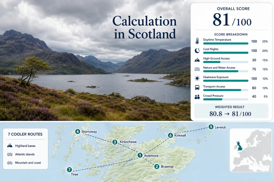
Three Highland bases and four island towns form the shared map, score and comparison set.
Median July–August average maximum across the seven cited Met Office stations.
Typical overnight relief remains strong across both island and Highland bases.
Its July–August average maximum is approximately 13.9°C, with Atlantic wind as the main comfort trade-off.
Direct rail access combines with a seven-day bus connection toward Glenmore and Cairngorm Mountain.
Island sailings, rural roads and exposed mountain days remain sensitive to current operational and weather conditions.
Highland Bases and Atlantic Island Planning Centres
The route set stretches from the Cairngorms and Wester Ross to Lewis, Orkney, Shetland and Tiree. Island markers emphasize maritime cooling, while the inland markers show where rail, forest and high-ground access can support a less-hot summer itinerary.
This marker map is built for planning orientation. Markers show selected route centres, not guaranteed legal parking, ferry berths, trailheads or exact viewpoints. Use the named Google Maps links and official transport information before travelling.
Scotland Highland and Island Cooler Escape Suitability Score
This is a transparent editorial suitability index based on disclosed climate, landscape, access and pressure factors. It is not an official climate classification or a weather forecast.
Weighted total: 100×0.25 + 100×0.20 + 30×0.15 + 75×0.15 + 100×0.10 + 80×0.10 + 40×0.05 = 80.8 → 81/100
Method: Route count does not add bonus points. Each route carries equal weight, and route-level values are combined using the median before the fixed factor weights are applied.
Cairngorm Valleys, Wester Ross and Atlantic Island Bases
The island routes produce the lowest daytime temperatures, while the Highland routes provide the strongest combination of night cooling, forest access and reachable high ground. Each card uses the same July–August climate window as the suitability score.
Aviemore
Approximately 18.5°C by day and 9.3°C at night define the July–August station averages. The village sits around 220 metres above sea level and functions as the most practical car-light Highland base in the set.
ScotRail lists direct services, while the Aviemore Adventurer links the town with Glenmore and Cairngorm Mountain seven days a week. Rothiemurchus, the River Spey and Loch Morlich provide shaded or waterside alternatives when exposed upland weather deteriorates.
Braemar
Braemar’s station averages are approximately 17.8°C maximum and 8.8°C minimum across July and August. Its village elevation is close to 340 metres, placing the accommodation base higher than most Scottish towns before any mountain travel begins.
Stagecoach routes 201, 202 and 206 serve the Deeside corridor toward Braemar. Linn of Dee, Glen Muick and the southern Cairngorm approaches offer high-road and walking options, but road-end capacity controls can affect popular summer days.
Kinlochewe
Atlantic-west Highland conditions shape this route more than village elevation. July–August averages reach approximately 18.3°C by day and 10.7°C at night, while measurable rain occurs on about 16 to 17 days per month.
The main reserve access for Beinn Eighe and Loch Maree Islands National Nature Reserve lies beside Kinlochewe, with the Coille na Glas-Leitir trail car park about 2.5 kilometres west of the visitor centre. Mountain, woodland and freshwater access are therefore concentrated within a short road corridor.
Cool does not mean dry here. Waterproof layers and a lower-level woodland alternative matter more than chasing an exact daily itinerary.
Stornoway
Stornoway Airport records a July–August average maximum of approximately 16.3°C and an average minimum near 10.9°C. The narrow day-to-night range reflects strong maritime influence rather than Highland elevation.
The Ullapool–Stornoway crossing takes about 2 hours 45 minutes. CalMac’s 2026 summer timetable runs from March 27 to October 18, and vehicle reservations are recommended. Accommodation demand is high in summer, so ferry and lodging availability should be treated as one combined planning constraint.
Lerwick
Lerwick is the clearest low-heat choice in the portfolio. The Met Office station’s July–August averages are approximately 13.9°C maximum and 9.3°C minimum, with average wind close to 11 knots and rain on roughly 12 days per month.
NorthLink connects Shetland with Aberdeen and Orkney, while the council-supported bus network links Lerwick with Sumburgh and other island communities. Ferry cabins, vehicle spaces and flights should be arranged before committing to fixed accommodation dates.
Kirkwall
Kirkwall’s July–August station averages are approximately 16.2°C by day and 10.4°C at night. Rainfall frequency is close to 12 days per month, while average wind remains around 10.6 knots.
Orkney’s 2026 summer bus network provides useful links from Kirkwall to Stromness, the Ring of Brodgar, Skara Brae and the airport. This makes the town a stronger car-light island base than the scattered settlement pattern might suggest.
Tiree
Tiree combines a July–August average maximum near 16.4°C with a comparatively mild average minimum of 11.4°C. The same station averages about 177 sunshine hours per month across the target window, but wind remains a defining part of the island climate.
CalMac’s Oban–Coll–Tiree summer timetable runs from March 27 to October 18 in 2026, and direct Glasgow flights provide an alternative to the ferry. The landscape is predominantly low and exposed, so the cooling mechanism is maritime rather than altitude-based.
Atlantic Air Is Coolest, but Not Calmest
Lerwick Sets the Lowest Daytime Baseline
A July–August average maximum near 13.9°C places Lerwick well below the Highland stations. The trade-off is sustained exposure: average wind is close to 11 knots, trees provide little shelter and low cloud can reduce visibility without producing heavy heat.
Tiree Couples Sunshine With Persistent Airflow
Tiree is not the coldest route, but its low-lying position allows Atlantic airflow to remain influential across the island. Sunshine averages are relatively high for western Scotland, while wind can make exposed beaches feel substantially cooler than the thermometer suggests.
Cairngorm Bases Gain More Night Relief
Braemar and Aviemore can experience warmer afternoons than Lerwick, yet their average minima remain below 10°C. That stronger day-to-night drop can suit hiking-oriented stays where evening recovery matters more than maintaining the lowest possible daytime temperature.
Seven Routes by Heat, Access and Weather Trade-Off
The same seven destinations used by the map and score are compared without treating one climate measure as a universal winner. The lowest-heat route is not the easiest mountain base, and the strongest public-transport route is not the quietest at peak season.
| Route | July–August Max | July–August Min | Primary Access | Cooling Advantage | Main Trade-Off |
|---|---|---|---|---|---|
| Aviemore | 18.5°C | 9.3°C | Direct rail and local bus | Forest, loch and high-ground choice | Holiday parking pressure |
| Braemar | 17.8°C | 8.8°C | Deeside bus or car | High village and strong night cooling | Road-end capacity and fewer onward services |
| Kinlochewe | 18.3°C | 10.7°C | Rural bus with car advantage | Loch Maree, forest and mountain access | Frequent rain and limited transport |
| Stornoway | 16.3°C | 10.9°C | Ferry or flight | Maritime moderation and island services | Accommodation and ferry booking pressure |
| Lerwick | 13.9°C | 9.3°C | Ferry or flight with buses | Lowest daytime heat exposure | Wind, fog and long mainland journey |
| Kirkwall | 16.2°C | 10.4°C | Ferry or flight with summer buses | Cool coast with structured island transit | Vehicle and accommodation capacity |
| Tiree | 16.4°C | 11.4°C | Ferry or direct flight | Atlantic airflow and relatively high sunshine | Exposure and limited local transport |
Cairngorm Rail and Bus Access Versus Island Timetables
Aviemore and Braemar Support Different Car-Light Plans
Aviemore has direct rail access and a seven-day mountain bus, making it possible to separate accommodation from parking at Glenmore. Braemar lacks rail but sits on the Deeside bus corridor. Its advantage begins after arrival: the village is already positioned among high roads, pinewoods and mountain approaches.
Island Transport Must Be Booked as a Chain
Stornoway, Lerwick, Kirkwall and Tiree require coordination between mainland transport, ferry or flight, local services and accommodation. A confirmed room without a matching vehicle space can be unusable, while a ferry arrival after the final local connection can create an unplanned taxi or rental-car requirement.
Operational check: CalMac’s Stornoway and Tiree summer timetables run from March 27 to October 18, 2026. NorthLink publishes separate schedules and an availability calendar for Orkney and Shetland. Service status should be checked again shortly before departure because Atlantic weather and technical disruption can alter sailings.
Kinlochewe Rainfall and the East–West Highland Divide
The Highland routes are all cool by the score threshold, but they do not share the same summer weather burden.
Wester Ross Carries the Wettest Pattern
Kinlochewe averages roughly 16.7 days with at least 1 mm of rain per month across July and August. The route remains valuable because Loch Maree, woodland and lower reserve trails create alternatives when the Beinn Eighe mountain route is cloud-covered.
Braemar Gains an Eastern Rain-Shadow Advantage
Braemar averages about 12.1 measurable-rain days per month across the same window. Its cooler nights therefore combine with a lower rain-day frequency than Kinlochewe, although convective showers and rapid upland changes remain possible.
Island Rain Is Often Paired With Wind
Kirkwall and Lerwick record fewer measurable-rain days than Kinlochewe, but exposed airflow can extend the practical effect of a passing shower. Windproof outer layers are often as relevant as waterproofing on coastal routes.
Late Light, Ferry Capacity and Weather-Dependent Days
Northern Evening Light Changes the Daily Rhythm
Lerwick, Kirkwall and Stornoway retain very late summer twilight. Longer usable evenings can absorb a delayed start or a passing weather front, but light bedrooms and early ferry departures can work against sleep. Blackout curtains become a practical accommodation feature rather than a minor preference.
Build One Flexible Day Into Island Stays
Atlantic routes work more reliably when one day can move between coastal walking, town visits and ferry-dependent excursions. Highland stays need the same flexibility in a different form: exposed mountain plans should be interchangeable with forest, loch or valley routes when cloud base and wind deteriorate.
Before departure: Check the current Met Office forecast and warnings, ScotRail or Stagecoach service updates for Highland routes, and CalMac or NorthLink status for island travel. A historical climate average describes the route’s baseline; it does not remove the possibility of an unusually warm, wet or windy summer day.