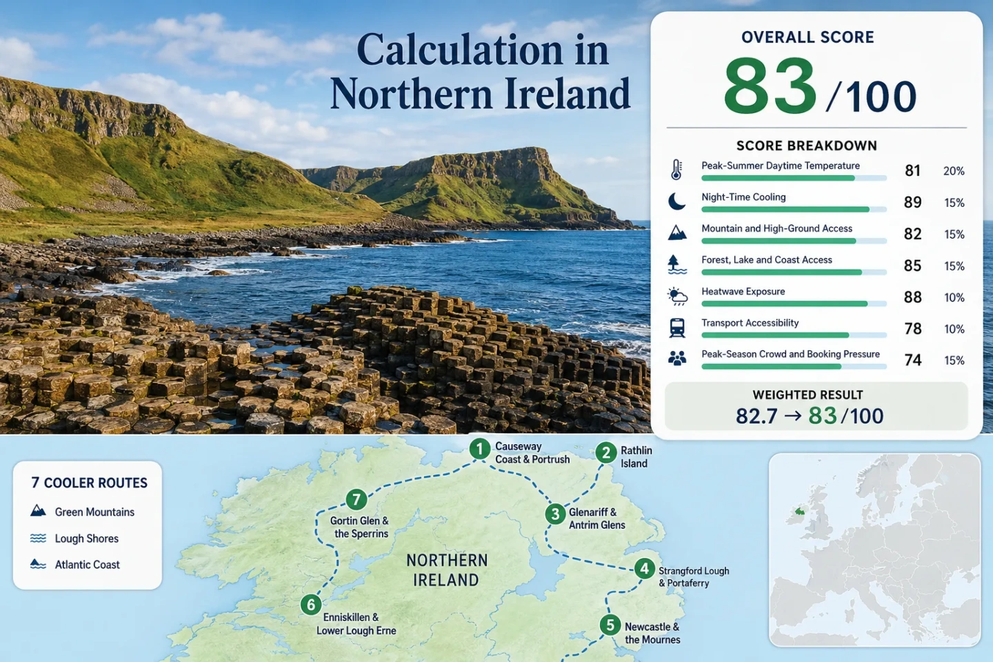
Northern Ireland Coolcation Routes: Causeway Air, Lough Shores and Green Mountains
Northern Ireland’s summer-cooling pattern comes from exposed North Atlantic coasts, sea-lough edges, forested glens and short climbs into green uplands rather than alpine elevation. Across seven route centres, the 1991–2020 July–August median is about 18.3°C by day and 11.4°C at night. Wind, rain, ferry capacity and busy coastal parking remain the main planning trade-offs.
The same Causeway, island, glen, lough and mountain set is used for the map, score and comparison.
Calculated from the seven direct or representative Met Office station values used in the score.
Cool nights are a consistent advantage, including on the coast where daytime wind can vary sharply.
A rain day means at least 1 mm; short showers and full wet days are not separated in this figure.
Portrush has rail access, while Newcastle has direct coach links and mountain walks rising from town.
Rathlin sailings, Carrick-a-Rede slots and Causeway-area parking deserve earlier checks in peak weeks.
Causeway, Lough and Mountain Route Geography
The route set stretches from Rathlin and the Causeway Coast through the Antrim Glens, then south to Strangford and the Mournes and west to Lower Lough Erne and the Sperrins.
This marker map is built for planning orientation. Marker positions use approximate public location centres, not guaranteed legal parking, trailheads or exact viewpoints. Use each route card for Google Maps links and access checks before travelling.
Northern Ireland Cooler Escape Suitability Score
This transparent editorial suitability index uses disclosed climate, landscape, access and pressure factors. It is not an official climate classification or a weather forecast.
Method: The July and August mean daily maxima were averaged for each route; the median of seven route values was then normalised with the fixed temperature scale.
Route values: Causeway Coast 18.29°C; Rathlin 18.29°C; Glenariff 18.83°C; Strangford 17.71°C; Mournes 19.10°C; Lower Lough Erne 18.92°C; Sperrins 17.42°C.
Station mapping: Portrush is direct for the Causeway and representative for Rathlin, about 35 km southwest; Ballykelly is a north-coast representative for Glenariff, about 60 km west; Lough Cowey is near Portaferry; Murlough is near Newcastle; Castlederg represents the western inland Lough Erne route, about 50 km northwest; Lough Fea represents the exposed Sperrin uplands, about 45 km east. Station codes are not published on the cited location pages.
Period: Met Office station normals, 1991–2020.
Sources: Portrush, Ballykelly, Lough Cowey, Murlough, Castlederg, Lough Fea.
Method: July–August mean daily minima were averaged by route and the seven-route median was compared with the fixed night-cooling scale.
Route values: Causeway Coast 12.54°C; Rathlin 12.54°C; Glenariff 11.62°C; Strangford 10.99°C; Mournes 11.40°C; Lower Lough Erne 10.81°C; Sperrins 10.57°C.
Interpretation: Every route falls inside the score system’s main overnight relief band. Coastal wind does not enter the formula; the factor uses measured minimum-temperature normals only.
Period: Met Office station normals, 1991–2020.
Sources: The same six Met Office location-specific normal tables mapped in the daytime factor.
Method: Each route was scored with the fixed elevation-access rubric, then the route median was used.
Route scores: Causeway 30 — low coast with limited height gain; Rathlin 30 — low island terrain; Glenariff 60 — a glen-to-plateau ascent; Strangford 30 — low sea-lough shore; Mournes 60 — meaningful high ground rises directly behind Newcastle; Lough Erne 30 — low lough base; Sperrins 60 — direct access to broad upland roads and trails.
Current access basis: Public park and route descriptions reviewed July 18, 2026.
Sources: Glenariff Forest Park, Gortin Glen Forest Park, Mourne Mountains.
Method: The fixed rubric measures physical access within 30 minutes, not scenery quality. The route median is used.
Route scores: Causeway 75 — Atlantic coast; Rathlin 75 — sea coast; Glenariff 100 — extensive forest plus coast; Strangford 100 — sea lough plus woodland; Mournes 100 — coast plus forested mountain approaches; Lough Erne 100 — large lough plus wooded islands and shores; Sperrins 100 — Gortin forest plus upland water and moorland.
Current access basis: Public land and visitor information reviewed July 18, 2026.
Sources: Strangford Lough, Glenariff Forest Park, Gortin Glen Forest Park, Giant’s Causeway coast.
Method: Proxy Dataset calculation. The Met Office UKCP18 12 km layer defines hot summer days as annual days above 30°C. Exact route-cell extraction was not treated as available from the public summary, so the 1.5-day upper edge of the lowest displayed class was applied conservatively to every route rather than claiming a more precise count.
Route values: Seven routes × 1.5 days/year upper bound. Dividing by the 62 days in July–August gives 2.42%; linear interpolation between the fixed 2% and 5% thresholds gives 87.9, rounded to 88.
Coverage: Modelled annual threshold frequency, not an observed daily station count. The conservative ceiling avoids assigning a 100-point score from an unextracted zero.
Period: Historical baseline context 2001–2020; public 12 km UKCP18 projection layer.
Sources: Met Office Annual Count of Hot Summer Days, 12 km layer fields and class breaks.
Method: Current public transport and ferry access was scored with the fixed rubric; the seven-route median was used.
Route scores: Causeway 100 — rail to Portrush plus coastal buses; Rathlin 20 — mainland transfer and capacity-limited ferry; Glenariff 40 — bus corridor but a car simplifies trail access; Strangford 60 — bus connections plus half-hourly ferry pattern; Mournes 100 — direct Belfast–Newcastle coaches; Lough Erne 80 — intercity coach to Enniskillen with local limitations; Sperrins 40 — multi-stage access and car-useful trailheads.
Current service basis: Timetables and journey-planning systems reviewed July 18, 2026. Live schedules can change.
Sources: Translink, Rathlin Ferry timetable, Strangford ferry timetable.
Method: The crowd rubric uses official booking requirements, ferry capacity and access concentration where comparable occupancy statistics were unavailable. The route median was used.
Route scores: Causeway 40 — concentrated visitor and parking demand; Rathlin 40 — fixed ferry capacity; Glenariff 80 — dispersed forest use; Strangford 80 — regular ferry but event queues can form; Mournes 60 — Newcastle and main trailheads tighten on fine weekends; Lough Erne 80 — broad shore and water-based dispersion; Sperrins 100 — comparatively diffuse recreation pressure.
Period: Current capacity and booking rules reviewed July 18, 2026; this factor is a categorical proxy rather than a three-year occupancy series.
Sources: Carrick-a-Rede booking requirements, Giant’s Causeway visit planning, Rathlin sailing availability, Strangford sailing pattern.
Atlantic Coasts, Sea Loughs and Green Uplands
The route cards keep the climate station relationship visible. Temperature figures are July–August 1991–2020 averages, not forecasts.
Causeway Coast and Portrush
Portrush gives the route set its clearest car-light coastal base. Rail reaches town, while buses and organised trips can connect the Giant’s Causeway corridor. The sea moderates daytime heat, but exposed cliff paths can shift from bright to windy and wet within one outing.
Capacity issue: On-site parking and visitor experiences around the Giant’s Causeway and Carrick-a-Rede have booking controls or strong advance-booking signals. Coastal walking itself is broader than the ticketed attractions, so separating a walk day from an attraction slot reduces timetable pressure.
Rathlin Island
Rathlin replaces mountain cooling with maritime exposure. The island’s open coast can feel distinctly fresher than sheltered inland towns, but wind direction matters more than elevation. Portrush is used as the representative climate station; the island can be more exposed and local conditions can diverge.
The summer timetable allows day trips, yet availability remains the controlling variable. A calm morning does not remove the need to check the return sailing, and a sold-out outward or return leg changes the route entirely.
Glenariff and the Antrim Glens
Glenariff combines tree cover, waterfalls and a steep glacial valley with access toward higher Antrim ground. That makes it a more reliable shade-and-height choice than a bare coastal stop when sunshine strengthens, although humid air after rain can feel close in the lower gorge.
Ballykelly, roughly 60 km west, is the representative station. Its maritime north-coast setting supports comparison, but Glenariff’s enclosed topography can hold cloud and rainfall differently. The 3 km river walk from Waterfoot offers a lower-level option when upper paths are wet or visibility is poor.
Strangford Lough and Portaferry
Strangford is the mildest daytime station match in the route set. The lough’s enclosed water, narrow tidal entrance and low shoreline create a different feel from the open Causeway: less Atlantic drama, more sheltered shore walking and short ferry-linked village movement.
The ferry crosses about 0.6 nautical miles in roughly eight minutes, compared with a road journey of around 46 miles. Departures normally alternate every 15 minutes between the two shores, giving each slipway a 30-minute pattern. Disruption still matters because the road fallback is long.
Newcastle and the Mourne Mountains
Newcastle records the warmest daytime normal in this seven-route comparison, yet it offers the clearest immediate height gain. Sea-level streets, forest approaches and steep mountain paths sit close together, so the cooling strategy is to climb rather than remain on the promenade during a warm afternoon.
Murlough is the direct nearby climate station. Slieve Donard reaches 850 m, but the route score remains 60 rather than a higher alpine-access grade because the accommodation base is low and the high ground requires a real ascent. On clouded or windy days, Tollymore-style forest walking is the more controlled alternative.
Enniskillen and Lower Lough Erne
Lower Lough Erne is a water-led coolcation rather than a high-ground route. Enniskillen supplies services and coach access, while the lough spreads activity across shore roads, islands, woodland and boat-based options. The broad water surface can moderate local heat, but it does not guarantee dry or windless conditions.
Castlederg, about 50 km northwest, is used as a western inland representative station. Its 10.8°C July–August minimum supports strong overnight cooling, while the high rain-day count makes flexible indoor or short-walk alternatives important. Boat plans require a separate wind check from the general land forecast.
Gortin Glen and the Sperrin Mountains
Gortin Glen sits six miles north of Omagh at the western gateway to the Sperrins. It offers a quieter combination of forest recreation, broad upland roads and lower-pressure walking than the Causeway or Newcastle. Lough Fea is the representative upland station and supplies the coolest daytime normal in the set.
The same exposed inland position that lowers temperature also raises the wet-weather trade-off. A 17.4°C normal is not a promise of a calm hiking day; low cloud, soft ground and wind can limit higher routes. Public transport reaches the wider area, but a car materially improves access to dispersed trailheads.
Seven Routes by Climate, Access and Capacity
Every mapped route appears in the same comparison. “Car-light” describes the base and main public links; remote viewpoints and dispersed trailheads can still require a taxi, tour or vehicle.
| Route | July–August day / night | Cooling mechanism | Car-light strength | Main planning constraint |
|---|---|---|---|---|
| Causeway Coast and Portrush | 18.3°C / 12.5°C | Open Atlantic air | Strong base | Parking and attraction slots |
| Rathlin Island | 18.3°C / 12.5°C proxy | Sea exposure | Ferry-led | Sailing availability and wind |
| Glenariff and the Antrim Glens | 18.8°C / 11.6°C proxy | Forest shade and plateau rise | Limited | Wet paths and last-mile access |
| Strangford Lough and Portaferry | 17.7°C / 11.0°C | Sea-lough moderation | Moderate | Ferry disruption creates a long detour |
| Newcastle and the Mourne Mountains | 19.1°C / 11.4°C | Rapid height gain from coast | Strong base | Fine-weekend trailhead pressure |
| Enniskillen and Lower Lough Erne | 18.9°C / 10.8°C proxy | Large-lough access and cool nights | Good hub | Rain and boat-specific wind |
| Gortin Glen and the Sperrin Mountains | 17.4°C / 10.6°C proxy | Exposed upland and forest | Limited | Dispersed trailheads and low cloud |
The Sea of Moyle Changes the Rathlin Decision
Exposure, Not Elevation
Rathlin’s cooling value comes from open-water airflow and a low maritime temperature range. It does not provide a mountain escape, so shelter can matter as much as the thermometer when wind strengthens.
The Return Sailing Controls the Day
A day plan is only robust when both ferry legs are secured. The operator allows booking up to the day of travel when space remains, but peak availability should not be assumed.
Wildlife Timing Narrows Some Visits
Seabird interest is strongest within a narrower window than the full mild-weather season. Late summer can remain cool and walkable after the main cliff-colony period has eased.
Strangford’s Eight-Minute Crossing Versus the 46-Mile Road
A Short Water Link With Large Route Value
The Strangford–Portaferry ferry covers about 0.6 nautical miles in roughly eight minutes. Driving around the lough is around 46 miles and can take about 90 minutes, so the ferry is not a decorative add-on; it determines whether a compact two-shore itinerary works.
Two Slipways, One Alternating Rhythm
Normal departures leave Strangford on the hour and half hour and Portaferry at quarter past and quarter to. A missed sailing is usually manageable; a suspension is not. Check the official timetable and alerts before committing to bookings on both shores.
Mourne Height and Sperrin Upland Air Are Different
Mournes: Warmer Base, Faster Vertical Change
Newcastle has the warmest route normal, yet the mountains rise immediately behind the coast. The practical advantage is choice: remain at sea level, use forest approaches or climb toward 850 m. The cost is steeper effort and more concentrated parking on clear weekends.
Sperrins: Lower Heat, Broader and Wetter Ground
Lough Fea’s 17.4°C daytime normal gives the Gortin–Sperrin route the lowest station signal. The landscape is broader and less vertically dramatic than the Mournes, with lower visitor pressure but weaker car-free movement and a stronger rain and low-cloud trade-off.
Forecast, Ferry and Forest Checks Before Departure
Use the Met Office warning service alongside a local forecast. Confirm Rathlin sailings or the Strangford timetable on the travel day, and check public forest notices where wind, maintenance or fire risk could affect Glenariff or Gortin. Mild climate normals do not remove short heat bursts, rough water, low cloud or heavy rain.