Ireland for Soft Summer Weather: Atlantic Towns, Green Roads and Cooler Breaks
Ireland’s western and northern edges combine low peak-summer temperatures with Atlantic airflow, long evening light and regular night-time cooling. The main planning trade-off is not severe daytime heat but frequent changeable weather: measurable rain, exposed winds, narrow coastal roads and concentrated visitor pressure at a few well-known stops.
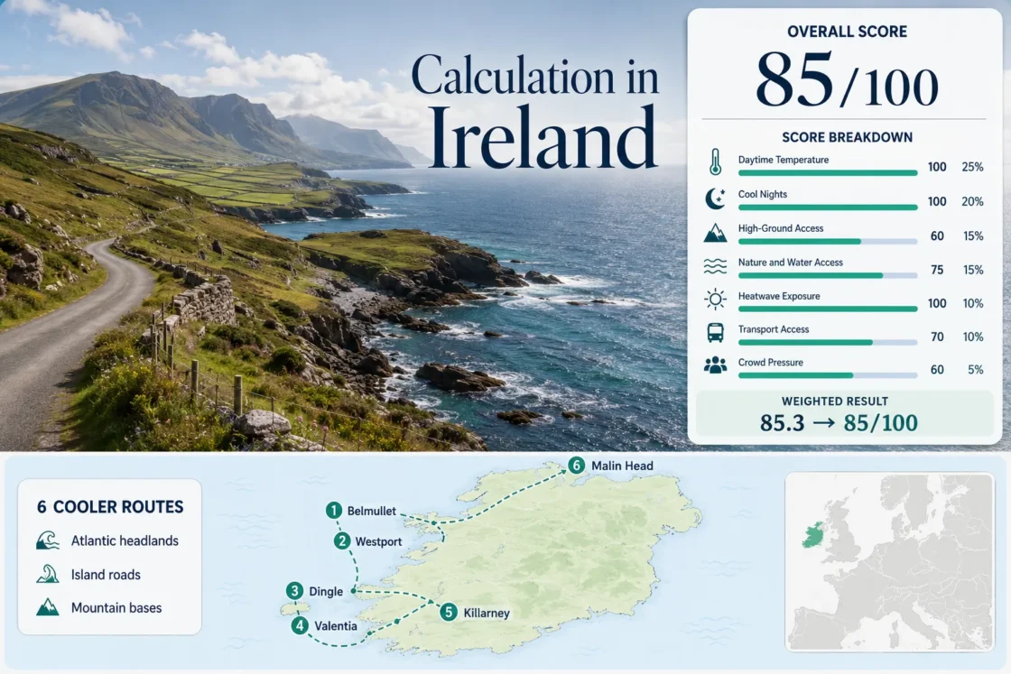
The same six route areas appear in the marker map, score evidence, destination portfolio and comparison matrix.
Median July–August mean daily maximum across the stated Met Éireann station mappings.
The selected coastal station mappings remain inside the scoring system’s strongest night-comfort band.
Its 1991–2020 July–August mean daily maximum averages about 17.1°C.
Both provide direct rail access, though island, mountain and peninsula extensions still need local buses, tours or a car.
The mapped stations average roughly 41–42 days with at least 0.2 mm of rain across the 62-day July–August window.
Atlantic Route Centers from Inishowen to Iveragh
The six markers follow exposed headlands, island approaches, western rail bases and mountain-backed towns. Marker numbers match the destination numbers used throughout the route portfolio.
Markers show selected cooler-route regions and approximate planning centers, not guaranteed legal parking, trailheads or exact viewpoints. Use the named Google Maps links and current local access information before travelling.
Ireland Atlantic Cooler Escape Suitability Score
This is a transparent editorial suitability index based on disclosed climate, landscape, access and pressure factors. It is not an official climate classification or a weather forecast.
Weighted total: 100×0.25 + 100×0.20 + 60×0.15 + 75×0.15 + 100×0.10 + 70×0.10 + 60×0.05 = 85.3 → 85/100
Method: Route count does not add bonus points. Every route carries equal weight, route-level values are combined using the median and the seven fixed factor weights remain unchanged.
Quality note: A common 1991–2020 official climate period is used, but Achill, Dingle and Killarney require representative coastal stations. The heatwave factor uses an official threshold-frequency fallback rather than a newly extracted ten-summer daily series.
Headlands, Island Roads and Rail-Linked Western Bases
The portfolio separates exposed coastal bases from towns that provide easier rail access to forests, lakes and mountain roads. Each climate figure uses the station mapping disclosed in the score evidence rather than an unsupported town-level estimate.
Belmullet and the Mullet Peninsula
July–August station signal: About 17.7°C mean daily maximum, 12.4°C mean daily minimum and 42.3 days with at least 0.2 mm of rain across the two-month period at Belmullet.
The Mullet Peninsula provides a low, highly exposed Atlantic base where beaches and bays are close to town. It offers the cleanest coastal-temperature match in the portfolio because the Met Éireann station is located in the same route area.
Westport and Achill Island
Rail service makes Westport a practical arrival base, while Route 450 and the daily TFI Anseo service extend access toward Achill. Anseo operates from 7:00 AM to 8:00 PM and requires at least one hour’s notice, with bookings available up to seven days ahead.
Belmullet’s representative station gives an exposed-coast signal of roughly 17.7°C by day and 12.4°C at night. Minaun Cliffs rise to 466 m, and Keem Bay sits between steep Atlantic slopes, giving the island stronger local height variation than Belmullet.
Dingle and Slea Head
Bus Éireann Route 275 links Tralee and Dingle, and its 2026 summer timetable runs from June 28 to August 22. The full peninsula still works more smoothly with a guided circuit, bicycle or carefully timed car journey.
Conor Pass adds immediate upland contrast to a low harbour base, while Slea Head remains maritime and exposed. The combination supports soft temperatures but not reliably dry walking weather.
Valentia Island and Portmagee
Direct station match: Valentia Observatory records July–August means of about 17.9°C for daily maxima and 12.9°C for minima. Measurable rain occurs on roughly 41.6 days across the two-month normal window.
The Portmagee bridge provides year-round road access without making the route dependent on a ferry. Local Link Route 287a connects Knightstown, Chapeltown, Portmagee and Caherciveen, but the published timetable requires closer planning than the rail-based routes.
Bray Head’s 4.5 km loop takes about 1 hour 45 minutes under the published route description, adding a manageable exposed-coast walk without requiring a major summit day.
Killarney and the MacGillycuddy's Reeks
Killarney is the portfolio’s strongest all-round car-light base: the InterCity station is in town, pedestrian access to the national park is available throughout the year and lake, woodland and mountain environments sit close together.
The Valentia proxy reports about 17.9°C daytime and 12.9°C night-time for July–August, but it is more maritime than inland Killarney. Warm, sheltered afternoons can therefore exceed the coastal proxy even when mountain and woodland options remain available.
Malin Head and Inishowen
Malin Head produces the lowest daytime climate-normal value in the set: approximately 17.1°C mean daily maximum across July and August, paired with a 12.3°C mean minimum.
The station also averages about 40.9 days with at least 0.2 mm of rain during the 62-day window. That figure measures frequent measurable precipitation, not 41 full days of continuous rain.
TFI Local Link Route 954 connects Malin Head and Carndonagh, including Sunday operation. Reaching Carndonagh from a national transport hub still requires an additional connection, so the route is cooler than it is simple.
Why Ireland’s Atlantic Edge Stays Soft but Rarely Dry
The mapped station normals cluster tightly for temperature but also show frequent measurable precipitation. The distinction between mild and dry matters more here than choosing between neighbouring coastal counties.
Belmullet’s Rain-Day Signal
Belmullet averages 21.1 July days and 21.2 August days with at least 0.2 mm of rain. A waterproof layer is therefore more useful than relying on a dry-week assumption, even though heavy all-day rainfall is not implied by the threshold.
Valentia’s Maritime Pattern
Valentia Observatory averages 20.8 measurable-rain days in both July and August. Dingle, Valentia and Killarney benefit from similar soft-temperature logic, but exposed peninsula walks and inland park days can experience different wind and shower timing.
Malin’s Cooler Northern Trade
Malin Head combines the lowest daytime value with 20.1 measurable-rain days in July and 20.8 in August. The lower heat signal does not remove the need for windproof clothing or a sheltered backup plan.
Westport and Killarney Reduce Car Dependence in Different Ways
Westport Works as an Island Gateway
Westport’s direct rail link solves the national journey, while Route 450 and TFI Anseo handle parts of the Achill extension. The booking requirement for Anseo rewards fixed daily plans rather than spontaneous movement between distant beaches.
Useful split: Stay in Westport for rail convenience and town services; stay on Achill when evening coastal air and reduced daily transfer time matter more.
Killarney Puts the Park at the Town Edge
Killarney’s rail station, pedestrian park access and local tour network allow a low-car trip without confining every day to one attraction. Lakes and woodland also provide practical alternatives when high cloud or wind makes exposed mountain plans unsuitable.
Main distinction: Killarney is easier without a car, but its sheltered inland position can run warmer than Valentia Observatory’s coastal temperature signal.
Slea Head, Valentia and Malin Head Reward Different Arrival Strategies
Slea Head Favors an Early Circuit
The peninsula combines narrow roads, concentrated viewpoints and an advisory clockwise traffic system used during the visitor season. Early movement reduces conflict with coaches and leaves more time for weather-driven stops.
Valentia Has Reliable Road Access but Limited Bus Frequency
The Portmagee bridge removes ferry uncertainty, while Route 287a provides a scheduled public-transport option. Limited departures mean a missed connection has greater consequences than it would in Killarney or Westport.
Malin Head Depends on the Carndonagh Connection
Route 954 improves local access and includes Sunday journeys, but Carndonagh remains the transfer point. The final headland leg is workable without a car only when regional and local schedules align.
Six-Route Decision Matrix for Heat, Access and Rain
Every route used by the map and score appears in the same order. Temperature and rain figures follow the disclosed Met Éireann station mappings; access and pressure notes reflect the route-level transport and capacity evidence.
| Route | July–August Max / Min | Measurable-Rain Signal | Car-Light Path | High-Ground Option | Peak-Season Pressure |
|---|---|---|---|---|---|
| Belmullet and the Mullet Peninsula | 17.7°C / 12.4°C | 42.3 days at ≥0.2 mm | Route 446; limited last-mile flexibility | Longer diversion from the low peninsula | Mostly dispersed |
| Westport and Achill Island | 17.7°C / 12.4°C representative | 42.3 days at ≥0.2 mm | Rail, Route 450 and bookable Anseo service | Minaun and Croaghaun island terrain | Concentrated at Keem and single-road stops |
| Dingle and Slea Head | 17.9°C / 12.9°C representative | 41.6 days at ≥0.2 mm | Route 275 to Dingle; tour or cycle for circuit | Conor Pass and Brandon massif | Regular road congestion |
| Valentia Island and Portmagee | 17.9°C / 12.9°C | 41.6 days at ≥0.2 mm | Route 287a with limited frequency | Bray Head and Iveragh uplands | Portmagee departure concentration |
| Killarney and the MacGillycuddy's Reeks | 17.9°C / 12.9°C representative | 41.6 days at ≥0.2 mm | Direct InterCity rail and town-edge park access | Carrauntoohil and the Reeks | Busy small car parks and major sights |
| Malin Head and Inishowen | 17.1°C / 12.3°C | 40.9 days at ≥0.2 mm | Route 954 after a regional connection | Inishowen hills and coastal climbs | Localized headland concentration |
Before departure: Check the current Met Éireann forecast, TFI or operator timetable, national-park notices and local road information. Atlantic wind, low cloud, temporary service changes and small-car-park capacity can alter the practical route choice even when the long-term temperature signal remains mild.