Laos for Elevated Summer Travel: Bolaven Plateau, Waterfalls and Highland Towns
Laos does not offer a dry, alpine-style escape during July and August. Its stronger summer options rely on elevation, persistent cloud, forest shade and rain-cooled afternoons. Paksong and the Bolaven waterfalls provide the clearest southern cluster, while Phonsavan, Phou Khoun and Sam Neua extend the highland pattern into central and north-eastern Laos. The trade-off is substantial: the same monsoon that moderates daytime heat also raises waterfall force, road-delay risk, humidity and landslide exposure.
Four Bolaven-area stops and three highland-town routes; route count does not increase the score.
The wettest part of the summer cycle, chosen to test peak-rain cooling rather than dry-season comfort.
A high road junction around the 1,300–1,400-metre band, but with limited visitor infrastructure.
Highland lodging, coffee-country roads and short access to Tad Fane and Tad Yuang.
Monsoon volume strengthens the falls while spray, mist and swollen water reduce access certainty.
Fog, standing water, slope failures and slow mountain transfers can outweigh modest temperature gains.
Bolaven Waterfall Roads and Laos Highland Towns
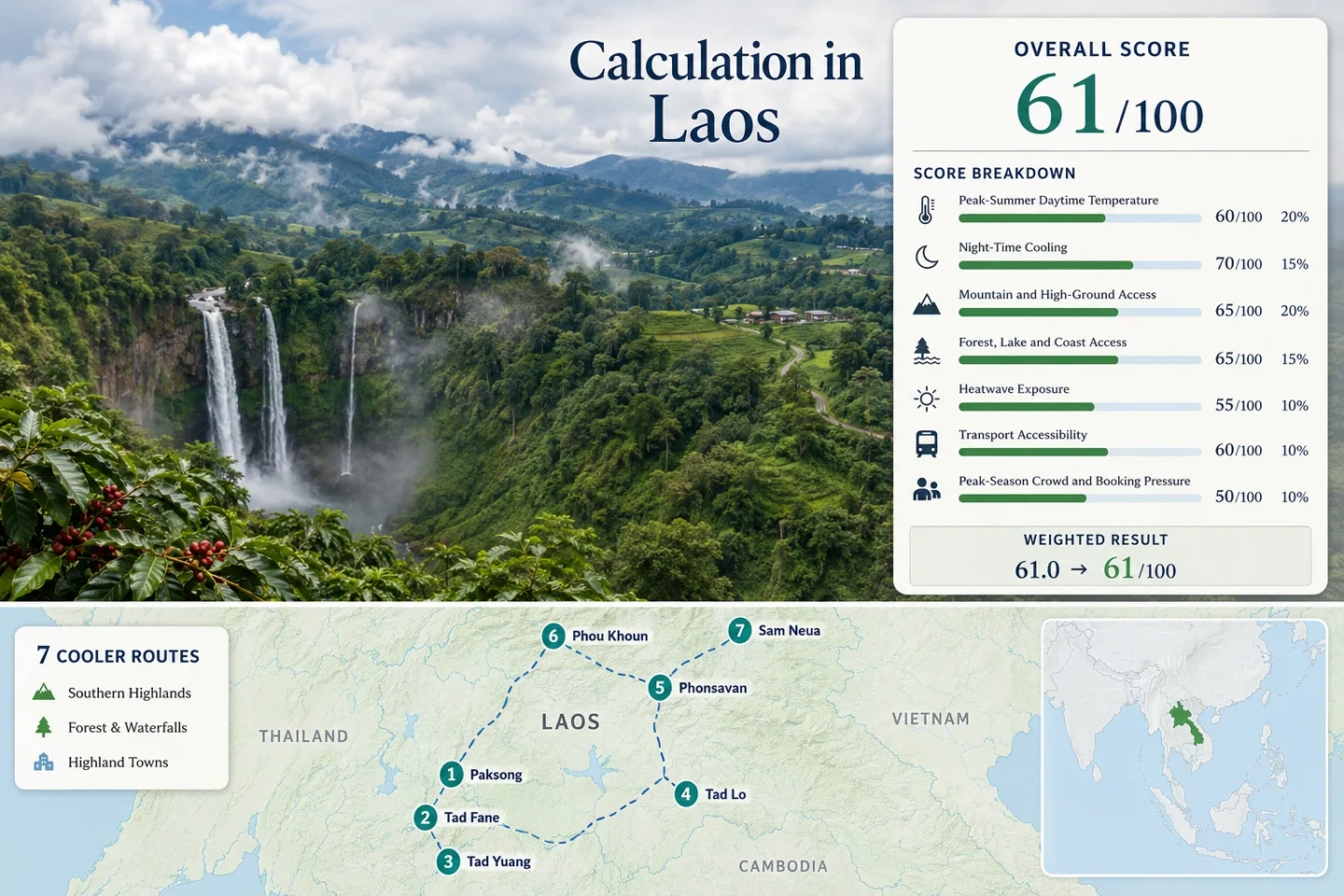
The markers connect the southern Bolaven cluster with three inland highland bases. They are planning centres rather than exact trailheads, parking positions or legal stopping points.
This marker map is built for planning orientation. Marker positions use approximate public location centres where exact viewpoints, trailheads, legal parking areas or pull-offs are not specified. Use each route card for Google Maps links and access notes before travelling.
Laos Highland and Waterfall Suitability Score
This is a transparent editorial suitability index based on disclosed climate, landscape, access and pressure factors. It is not an official climate classification or a weather forecast. The route set scores well for high-ground access, but warm monsoon nights and road dependence limit the overall result.
Weighted total: 50×0.25 + 30×0.20 + 100×0.15 + 75×0.15 + 63×0.10 + 60×0.10 + 80×0.05 = 61.05 → 61/100
Method: Route count does not add bonus points. Each route has equal weight inside a factor, route-level values are combined with the median, and the seven fixed factor weights are then applied. Humidity and rainfall are discussed as planning context but are not hidden score factors.
Bolaven Waterfalls, Plateau Roads and Highland Bases
The southern routes work as a compact waterfall-and-coffee circuit from Pakse, while the central and north-eastern towns require separate travel segments. The route cards use the same seven places as the map, score and comparison matrix.
Paksong Coffee Highlands
Champasak Province
Paksong is the most practical overnight base on the Bolaven Plateau. The town sits at roughly 1,250–1,300 metres, placing accommodation inside the plateau climate rather than requiring a daily climb from Pakse. The rounded July–August planning value used for the score is about 27.5°C by day and 22.0°C at night.
Tad Fane and Dong Hua Sao
Bolaven Plateau, Champasak
The twin falls drop into a forested gorge near the Km 38 section of Route 16E. A plateau-edge base near the viewpoint is around the 1,000-metre band, with representative planning inputs of approximately 27.5°C daytime and 22.0°C night-time for July–August. The cooling effect comes from elevation, forest cover and persistent wet-season cloud rather than dry mountain air.
Tad Yuang Waterfall
Bolaven Plateau, Champasak
Tad Yuang is one of the easier waterfall stops to combine with Paksong. Official tourism directions place the turnoff about 12 kilometres west of Paksong and around 40 minutes from Pakse in normal conditions. The representative plateau planning value is roughly 27.5°C / 22.0°C in July–August.
Tad Lo and Tad Hang
Salavan Province
Tad Lo is a waterfall village on the lower north-western side of the Bolaven circuit. At only a few hundred metres above sea level, it gives up some of Paksong’s altitude advantage: the rounded July–August planning values are about 28.5°C by day and 22.0°C at night. Its strength is immediate river access and a slower village stay, not the lowest heat in the route set.
Phonsavan and the Plain of Jars
Xiangkhouang Province
Phonsavan stands at about 1,100 metres on an open central plateau. The rounded score input is approximately 27.0°C daytime and 19.5°C at night in July–August. Unlike the Bolaven waterfall stops, it offers a functioning town base, an airport at Xieng Khouang and dispersed cultural sites across the Plain of Jars landscape.
Phou Khoun Ridge
Luang Prabang Province
Phou Khoun is a high road junction rather than a resort town. Its base is commonly placed around the 1,300–1,400-metre band, and the published monthly reference supports a planning input of about 23.5°C by day and 19.5°C at night. That makes it the lowest-heat point in the seven-route set, but also one of the weakest for easy visitor infrastructure.
Sam Neua and Vieng Xai
Houaphanh Province
Sam Neua provides a remote north-eastern highland base near 950 metres, while Vieng Xai adds karst, caves and forested valleys roughly 30 kilometres away. The rounded route input is about 28.5°C daytime and 20.0°C at night for July–August. Houaphanh Airport can shorten the approach, but onward movement remains road-dependent.
Why Bolaven’s Summer Cooling Arrives With Heavy Rain
The Bolaven Plateau rises sharply east of the Mekong lowlands. Moist south-westerly monsoon air is forced upward, encouraging cloud, rain and lower daytime temperatures around Paksong. The cooling is real in a relative sense, but it is paired with high humidity and limited drying time.
Paksong Versus the Pakse Lowlands
Paksong places the sleeping base more than a kilometre above sea level, while Pakse sits beside the Mekong at low elevation. Starting on the plateau avoids a daily morning climb and preserves more of the night-time temperature advantage.
Flow Strength Versus Viewpoint Clarity
Tad Fane and Tad Yuang can carry powerful monsoon flow, but deep cloud and spray may hide the gorge. A dramatic water volume does not guarantee a clear panorama, safe lower access or swimmable conditions.
Coffee Roads and Short Climate Changes
Route 16E crosses elevation bands, forest edges and exposed agricultural land over short distances. A mild, misty stop near Paksong can be followed by a warmer break toward Tad Lo, so one plateau forecast should not be treated as uniform.
Heat, Rain and Access Across the Seven Routes
The temperature columns use the same July–August proxy inputs as the score. “Transport pattern” describes the practical last-mile structure rather than a guaranteed timetable.
| Route | Base elevation | Day / night proxy | Transport pattern | Water and forest access | Main summer trade-off |
|---|---|---|---|---|---|
| Paksong Coffee Highlands | About 1,250–1,300 m | 27.5°C / 22.0°C | Road from Pakse; local vehicle useful | Forest and plantation country | Frequent rain and low cloud |
| Tad Fane and Dong Hua Sao | Near the 1,000 m band | 27.5°C / 22.0°C | Route 16E; private transfer or tour | Forest plus major gorge | Spray, slick paths and hidden views |
| Tad Yuang Waterfall | High plateau zone | 27.5°C / 22.0°C | Paved road, site turnoff and stairs | Forest and waterfall | Lower access may be unsafe after rain |
| Tad Lo and Tad Hang | About 300 m | 28.5°C / 22.0°C | Longer road loop; limited local service | River and waterfalls in the village zone | Warmer nights than Paksong |
| Phonsavan and the Plain of Jars | About 1,100 m | 27.0°C / 19.5°C | Airport gateway plus local road trips | Open plateau with woodland edges | Rain, dispersed sites and UXO restrictions |
| Phou Khoun Ridge | About 1,300–1,400 m | 23.5°C / 19.5°C | Road-only mountain junction | Forested ridges | Fog and weak visitor infrastructure |
| Sam Neua and Vieng Xai | About 950 m | 28.5°C / 20.0°C | Airport gateway, then road to caves | Karst valleys, forest and rivers | Long onward transfers in heavy rain |
Paksong for Balance, Phou Khoun for Lower Heat
Paksong as the Usable Plateau Base
Paksong is the more balanced choice when the trip needs lodging, food, coffee-country roads and short access to two major waterfalls. It does not produce the lowest proxy daytime temperature, but it avoids the infrastructure penalty attached to Phou Khoun.
Good for: A two- or three-night southern highland stay with flexible waterfall timing.
Phou Khoun as the Lowest-Heat Road Stop
Phou Khoun’s higher ridge position produces the lowest July–August daytime proxy in the set. It works as a temperature-led road break, not as a full-service coolcation centre. Fog, steep roads and limited lodging choice reduce its practical advantage.
Good fit: Overland travellers already moving between northern and central Laos who can absorb weather delays.
July–August Decisions for Waterfalls and Mountain Roads
Early July: Build Flexibility Into the Bolaven Loop
Rain is already established, but multi-day road disruption is generally less predictable than a simple wet-versus-dry calendar suggests. Base in Paksong and hold Tad Fane, Tad Yuang and Tad Lo as movable day choices.
Late July: Strong Flow, Higher Path Risk
Waterfall volume becomes a stronger reason to visit, while lower stairways, river edges and unsealed approach sections demand more conservative decisions. Do not treat swimming access as guaranteed.
August: Protect Transfer Days
Long mountain-road movements to Phou Khoun, Phonsavan or Sam Neua need generous time buffers. A flight to Xieng Khouang or Houaphanh can shorten the approach, but local road travel remains exposed to rain and cloud.